The purpose of this blog is the creation of an open, international, independent and free forum, where every UFO-researcher can publish the results of his/her research. The languagues, used for this blog, are Dutch, English and French.You can find the articles of a collegue by selecting his category. Each author stays resposable for the continue of his articles. As blogmaster I have the right to refuse an addition or an article, when it attacks other collegues or UFO-groupes.
Druk op onderstaande knop om te reageren in mijn forum
Zoeken in blog
Deze blog is opgedragen aan mijn overleden echtgenote Lucienne.
In 2012 verloor ze haar moedige strijd tegen kanker!
In 2011 startte ik deze blog, omdat ik niet mocht stoppen met mijn UFO-onderzoek.
BEDANKT!!!
Een interessant adres?
UFO'S of UAP'S, ASTRONOMIE, RUIMTEVAART, ARCHEOLOGIE, OUDHEIDKUNDE, SF-SNUFJES EN ANDERE ESOTERISCHE WETENSCHAPPEN - DE ALLERLAATSTE NIEUWTJES
UFO's of UAP'S in België en de rest van de wereld Ontdek de Fascinerende Wereld van UFO's en UAP's: Jouw Bron voor Onthullende Informatie!
Ben jij ook gefascineerd door het onbekende? Wil je meer weten over UFO's en UAP's, niet alleen in België, maar over de hele wereld? Dan ben je op de juiste plek!
België: Het Kloppend Hart van UFO-onderzoek
In België is BUFON (Belgisch UFO-Netwerk) dé autoriteit op het gebied van UFO-onderzoek. Voor betrouwbare en objectieve informatie over deze intrigerende fenomenen, bezoek je zeker onze Facebook-pagina en deze blog. Maar dat is nog niet alles! Ontdek ook het Belgisch UFO-meldpunt en Caelestia, twee organisaties die diepgaand onderzoek verrichten, al zijn ze soms kritisch of sceptisch.
Nederland: Een Schat aan Informatie
Voor onze Nederlandse buren is er de schitterende website www.ufowijzer.nl, beheerd door Paul Harmans. Deze site biedt een schat aan informatie en artikelen die je niet wilt missen!
Internationaal: MUFON - De Wereldwijde Autoriteit
Neem ook een kijkje bij MUFON (Mutual UFO Network Inc.), een gerenommeerde Amerikaanse UFO-vereniging met afdelingen in de VS en wereldwijd. MUFON is toegewijd aan de wetenschappelijke en analytische studie van het UFO-fenomeen, en hun maandelijkse tijdschrift, The MUFON UFO-Journal, is een must-read voor elke UFO-enthousiasteling. Bezoek hun website op www.mufon.com voor meer informatie.
Samenwerking en Toekomstvisie
Sinds 1 februari 2020 is Pieter niet alleen ex-president van BUFON, maar ook de voormalige nationale directeur van MUFON in Vlaanderen en Nederland. Dit creëert een sterke samenwerking met de Franse MUFON Reseau MUFON/EUROP, wat ons in staat stelt om nog meer waardevolle inzichten te delen.
Let op: Nepprofielen en Nieuwe Groeperingen
Pas op voor een nieuwe groepering die zich ook BUFON noemt, maar geen enkele connectie heeft met onze gevestigde organisatie. Hoewel zij de naam geregistreerd hebben, kunnen ze het rijke verleden en de expertise van onze groep niet evenaren. We wensen hen veel succes, maar we blijven de autoriteit in UFO-onderzoek!
Blijf Op De Hoogte!
Wil jij de laatste nieuwtjes over UFO's, ruimtevaart, archeologie, en meer? Volg ons dan en duik samen met ons in de fascinerende wereld van het onbekende! Sluit je aan bij de gemeenschap van nieuwsgierige geesten die net als jij verlangen naar antwoorden en avonturen in de sterren!
Heb je vragen of wil je meer weten? Aarzel dan niet om contact met ons op te nemen! Samen ontrafelen we het mysterie van de lucht en daarbuiten.
In the depths of the English Channel lies a lost city that has been submerged for over 8,000 years. It is known as Doggerland. One maritime archaeologist , Garry Momber, has spent two decades exploring these waters to uncover its secrets. The English Channel is notoriously difficult to navigate, with cold water and powerful tides creating treacherous conditions for divers.
However, Momber's meticulous preparations have paid off, revealing that Doggerland is a treasure trove of ancient wood that has survived underwater for millennia. These preserved hunter-gatherer landscapes offer a rare glimpse into life from another age, and composite structures like these are of international significance. The discovery of what is believed to be the oldest boat building site in the world adds to the intrigue of this remarkable find.
Sumer, in Mesopotamia, was called ‘the land of civilized kings’. It reached its peak around 6,500 years ago when it had the distinction of being a very advanced civilization with a sophisticated written language, magnificent architecture for the time, complex mathematics, and amazing astronomy. Hundreds of gods comprised its religious system. Sumerians believed that although humans and the gods once shared the earth together, they didn't share a co-equal existence. Humans, they believed, were designed for the express purpose of serving the gods. Their chief god, Anu, commissioned his son, Enki (Ea), and his daughter Ninki (Enki's half-sister) to create humans by sacrificing a god, mixing his body and blood with clay, and forming the first human being made in the likeness of the gods.
According to Sumerian mythology, human-like gods called Anunna had initially come to mine resources that were needed on their home planet. Now, with the creation of a human labor force, their duties were changed. They ruled over what was, for all practical purposes, a human slave race. Their base of operations was Mesopotamia, the land between the Tigris and Euphrates river. In the Epic of Gilgamesh, the world's first epic poem, it was called Eden.
At first, according to the texts, humans were unable to reproduce on their own. This proved inconvenient. So, Enki and Ninki found a way to modify the new species. The result was a man called Adapa, a fully functional and independent human being. Enki had given Adapa great wisdom and the ability to understand the concept of eternal life. But Adapa's curse was that he could never attain that which he was able to conceive.
Detail of The Adda Seal. Goddess Inanna, god Utu, god Enki and chief minister Usimu. (Public Domain)
Were it not for the Amarna texts, discovered all the way over in Egypt in the archives of the Egyptian king Amenophis, we might never know about Adapa. But in 1912 his story was verified and confirmed by a unique discovery in the Library of Ashurbanipal. Five partial fragments, since translated, were revealed that told part of the story, called Adapa and the South Wind.
According to the story, Adapa had risen to the position of priest or sage. One day, while fishing in the Persian Gulf, the sea became rough and his boat capsized. Adapa became angry and: "broke the wings of the south wind." He prevented it from blowing for seven days and nights. This, of course, caught the attention of the god Anu, who wanted to punish Adapa for the sin of hubris. But Enki came to Adapa's aid. He instructed him to journey to the abode of the goddess Tammuz, who, along with Gishzida, stood guard at the gates of heaven. While there, he was told not to eat or drink anything because heavenly food would kill him.
Adapa put on traditional sackcloth and ashes, the garb of mourning, and appeared before Tammuz and Gishzida, claiming he was in mourning because the two gods had disappeared from his land. Ever hospitable, they offered Adapa food and drink. Forewarned, he refused. Only later did he come to understand that he had made a mistake. When he was brought before Anu, Anu asked why he hadn't eaten the food that had been placed before him. He said it was because Enki had told him not to eat: "the bread and water of life."
At this, Anu laughed: "What ill has Adapa brought on mankind?" If Adapa had partaken of the food, he would have obtained immortality. As it is, humankind, the creation of Enki, would henceforth suffer disease and death.
The Flood by Vasily Petrovich Vereshchagin (1869) (Public Domain)
The Deluge
Compare this story to the biblical account. In Genesis, God forbid the first man from eating of the Tree of Immortality. In the Sumerian version, it was Enki. This is about to become an important distinction.
Adapa was sent back down to earth. Now the plot thickens. Enki's brother, Enlil, hadn't been told about Enki's work. He had wanted only an obedient slave race, and now Enki was tinkering with things like wisdom and eternal life. Enlil and Enki fought, and the battle continues to this day.
Enlil advised the gods that he was going to destroy the newly created human race with a great flood. Afterwards, he reasoned, they could start over from scratch. But Enki overheard the plans and contacted a righteous man named Utnapishtim.
The Deluge, frontispiece to Gustave Doré's illustrated edition of the Bible. Based on the story of Noah's Ark, this engraving shows humans and a tiger doomed by the flood futilely attempting to save their children and cubs.(1866) (Public Domain)
Ancient Sources Predating the Bible
It's important to remember that the Sumerian authors didn't believe they were the earliest human civilization. They claimed to have received all this from an earlier civilization that had, by their time, become extinct. Who comprised this civilization, and where they came from, is a mystery.
Added to the dilemma is the fact that when we read a text such as the Bible, we are reading the edited work of scholars who lived centuries ago. They made choices, compiling one work and condensing another, so it seems as if we are reading a seamless book written by one author. No one ever did that with ancient Sumerian texts. We read a little of this and a little of that, from here and there, and the story doesn't seem as uniform as the familiar Hebrew text. On top of that, some of the old texts are written in Sumerian hieroglyphs, some in Babylonian cuneiform, and others in ancient Egyptian. A modern editor has a lot to choose from, and can snip a little from one text or another, confidant that most of us, who don't read any of the ancient languages, will be none the wiser. But a comparison of Sumerian and Biblical texts, even in translation, is revealing.
One of the most important Sumerian texts is called Enki and the World Order. In this myth, Enki decided that the world needed to be managed by the gods or it would descend into chaos. He appointed various overseers to supervise such activities as managing the use of water and crops, building cities, herding domestic animals, overseeing the heavens, and managing the activities of women.
Both the Genesis Eden Story and the Sumerian texts address similar issues and help us understand what was going on in the minds of the old ones at the time of the birth of our civilization. They can be read as metaphors for historical precedents such as the agricultural revolution and city building. They are an attempt to explain why things are the way they are in the world. They point back to an earlier civilization, now lost to history. They reveal that our ancestors thought long and hard about philosophy and psychology. They point to what was even back then considered a lost golden age—paradise. They try to plumb the depths of human behavior and ask questions about the nature of good and evil.
In that sense, things haven't changed a great deal in the last 5,000 years. But there is another way to read these two stories. From a religious perspective, they are very different.
Is Eden Paradise?
Anton Parks is a French scholar who has devoted years to the Sumerian texts, even going so far as to translate them himself. He points out that the Bible portrays our ancient ancestors being very happy in Paradise. In the Sumerian texts, they are living in a concentration camp. In his translation God doesn't plant a garden for humankind in which he: "walks in the cool of the evening," as in Genesis. His version says the gods: "came in strength from beyond time. They were carried, one day, by the rebellion of the universe." His gods, the Anunna, were very real entities from beyond, who represented a patriarchal and a matriarchal regime. Enlil, the so-called ‘evil’ god who wanted to enslave the human race, was quite different from Enki, who befriended them.
A woman-serpent bends around the Tree of Knowledge as Adam and Eve reach into the branches. Line engraving by T. de Bry after J. van Winghe. (Wellcome Images / CC BY-SA 4.0)
The feminine presence, represented by Ninki, is often portrayed as a reptilian figure. Could she have been the inspiration for the serpent in the Eden of Genesis? If that is the case, then the serpent wasn't evil at all. She was trying to free humankind by offering them the gift of the knowledge of good and evil. She then wanted them to eat of the Tree of Life and: "be like gods." It was a good thing she was doing, not a bad one.
But Enlil won the day. Although he failed to keep them from eating the fruit of the Tree of Knowledge, he cast humans out of the garden before they ate from the Tree of Life. And since history is both interpreted and written by the winners, Enlil's story was later told in Genesis, not Enki's. That explains why the Genesis account emphasizes the fact that sword-wielding cherubim, or ‘Shining Ones’, were placed at the entrance to Eden in order to ensure that humans never attain the godhead, or eternal life. It has been said that the smartest thing the devil ever did was to convince humans that he didn't exist. This reading of the Sumerian myth goes one step further. It says that the smartest thing the devil ever did was to convince humans that he was God.
Jehovah the Evil God Enlil
According to Anton Parks, YHVH of the Bible, translated ‘The Lord’, is not the Creator. The creator is Enlil, the enslaver of humankind, henceforth known as the Demiurge. He is head of the Patriarchal system that wants to suppress freedom, especially the freedom of women. He doesn't want equality. He wants subservient slaves. He doesn't want creative, right-brained, intuitive thinkers. He wants left-brained, obedient servants who are forced to toil every day.
This reading of the story says that humans were upright-walking animals who were modified through DNA manipulation to fill the role of worker bees. The word Adam in Sumerian, according to Parks, means ‘animal’. Eden consists of the words E, meaning ‘home’ and den, which means ‘life’. Satan, in Sumerian, means ‘The Administrator’
Ancient Sumerian cylinder seal impression showing the god Dumuzid being tortured in the Underworld by galla demons (Public Domain)
Enki managed to grant wisdom to humans when he, through Ninki, the ‘serpent’ of Eden, gave them the ability to discern between good and evil. That caught Enlil by surprise. The best he could do was to drive them out of Eden and forbid their return. To put it bluntly, according to this reading of the story, the God whom monotheists have been worshipping for the last 5,000 years is not Jehovah, the creator God. He is Enlil, the patriarchal Demiurge—Satan himself. This explains the God of the Old Testament who sent the flood to destroy humankind, who commanded the Israelites to kill innocent Canaanite women and children, who was the justification for the Crusades and the Inquisition, who seems so incredibly bloodthirsty. It explains why the author of John in the New Testament could declare that: "we know we are of God and the whole world is in the hands of the evil one" (1 John 5:19). He recognized that humans have been fighting the good fight, trying to get back to Eden.
According to this interpretation, we are caught in a divine battle of competing spiritual forces. We still need to: "earn our daily bread by the sweat of our brow." It's just that we have turned our curse into a search for meaning. We want to get back to Paradise.
Gustave Doré, illustration to Paradise Lost"... he [Satan] held on /His midnight search, where soonest he might finde /The Serpent: him fast sleeping soon he found ..."(Public Domain)
Sophia, Wisdom the Word of God is Feminine
There are indications that the Gnostic texts, discovered in Nag Hammadi, Egypt, in 1945, sympathized with this version of the story. The Gnostics were an early Christian sect that was declared heretical by the Roman establishment. The church burned their scriptures and made sure none of them, except for perhaps, the Gospel of John, made it into the New Testament. But with the discovery of books that had been hidden away and kept from destruction, we now know that to the Gnostics, wisdom, or Sophia, represented a feminine energy that refused to be kept buried. She was the Logos, or Word of God.
The Gnostics believed there was a bigger game being played out, by forces outside of planet Earth. The universe is bigger than we realize, they declared. As a matter of fact, the universe is simply one cell in the immense body (Multiverse) that is God. Here on earth the battle between good and evil, between the feminine and the masculine, between Enki and Enlil, is raging. But good will eventually triumph.
This religious system of belief says we have an ‘angel’ on one shoulder and a ‘devil’ on the other. Their names are Enki and Enlil. The earth may be the domain of the Demiurge, but that domain itself is called ‘Mother Earth’, the world of Sophia, the goddess of wisdom, the divine spark that Enlil, the devil, strives to put out. The Demiurge may dominate our day to day reality, but Eden still awaits if we can only persevere. And we are not alone in the battle.
This is a completely different reading than the biblical account many of us grew up with, and whether we read it allegorically or historically, it causes us to pause and think about what we have been taught in our impressionistic youth—to contemplate the idea that we are involved in something a lot bigger than we thought.
Sheer Fluke: 7 of the Most Amazing Accidental Discoveries in Archaeology!
Sheer Fluke: 7 of the Most Amazing Accidental Discoveries in Archaeology!
Uncovering the mysteries of our past has always been a fascinating pursuit for humans. From exploring hidden caves and discovering ancient artifacts to deciphering cryptic scripts and unlocking the secrets of lost civilizations, the quest to understand our history continues to captivate and inspire us. While many people spend their entire lives searching for the next big discovery, some just stumble upon them. Some of the most important archaeological discoveries in history were made by normal people through sheer luck. These are the stories behind history’s most amazing accidental archaeological discoveries.
1. Terracotta Army: Found by Farmers
Few archaeological discoveries have been as amazing, or as surprising, as that of the Terracotta army . The Terracotta Army is a massive collection of life-size terracotta sculptures that depict the armies of Qin Shi Huang , China’s first Emperor and a man obsessed with gaining immortality.
The army was created over 2000 years ago during the Qin dynasty (221-206 BC). It was buried with Qin when his quest for immortality failed (and perhaps even killed him) and he died. The army was built to protect him in the afterlife.
*It lay buried and forgotten until 1974 when it was discovered by a group of Chinese farmers. Yang Zhifa, his brothers, and a neighbor, Wang Puzhi, were digging a well near the city of Xi’an in China’s Shaanxi province when they stumbled upon a pit containing strange terracotta fragments. They quickly realized they’d found something special.
Terracotta Warriors and Horses, is a collection of sculptures depicting the armies of Qin Shi Huang, the first Emperor of China. Xi'an, China.
People had been reporting pieces of terracotta figures in the region for centuries and so archaeologists were brought in to investigate. They discovered an enormous underground complex that contained thousands of life-sized terracotta warriors, horses, and even chariots. It’s believed the complex spans around 22,000 square meters with many areas still being left undiscovered.
The discovery of the Terracotta Army has been hailed as one of the most important archaeological finds of the 20th century. The figures are not only historically significant, but they also provide a unique insight into the art and culture of the Qin Dynasty. Today, the Terracotta Army is a UNESCO World Heritage site and a major tourist attraction in China.
2. Rosetta Stone: Was Nearly Used to Patch a Wall
It really is complete dumb luck that the Rosetta Stone was ever rediscovered. The stone is a large, black granite slab measuring around 3 feet tall and two feet wide. Upon it is inscribed a decree issued at Memphis in 196 BC on behalf of King Ptolemy V .
What makes the stone so special is that the decree was written in three scripts: Egyptian hieroglyphs, Demotic script, and Ancient Greek. This meant the stone could be used to decipher ancient Egyptian hieroglyphs which had been stumping historians for centuries.
The Rosetta Stone Trilingual decree: Egyptian Hieroglyphic (14 lines), Demotic (32 lines) and Greek (53 lines).
The stone was discovered on 15 July 1799 by Lieutenant Pierra-Francois Bouchard of the French army. He was overseeing the repair of an old fort near the town of Rosetta (now Rashid) in the Nile Delta when he noticed one of the stones his soldiers were going to use to patch a wall was covered in strange inscriptions.
Bouchard recognized its potential historical significance and reported the stone to his commander, General Jacques-Francois Menou. From there it was sent to Napoleon’s scientific institute in Cairo, the Institut d'Égypte where it was quickly revealed just how big a find the stone was.
After the French were defeated by the British in 1801, the Rosetta Stone became British property and was taken to the British Museum in London, where it remains on display to this day. Its discovery was a major breakthrough in the study of ancient Egyptian history and language and provided valuable insights into the culture and politics of the time.
3. The Dead Sea Scrolls: Unearthed by a Bored Shepherd
Another amazing find, the Dead Sea Scrolls are a collection of Jewish texts that were discovered in the mid-20th century near the Dead Sea, in the West Bank area of Israel. The discovery was made by a young Bedouin shepherd called Muhammad edh-Dhib and his cousin, Jum’a Muhammed, who were tending to their goats in the area.
According to the young men’s accounts, Muhammed noticed the caves and the curious edh-Dhib decided to go in and have a look. Inside he noticed some old-looking jars. He broke one of them open and found several scrolls (which turned out to be the Isaiah Scroll, Habakkuk Commentary, and Community Rule).
He took the scrolls back to his camp where they were put on display while everyone decided what to do with them. They eventually decided to sell them, but the first dealer they approached was unimpressed. He informed the Bedouins the scrolls were worthless; most likely having been stolen from a Synagogue.
They eventually found a dealer willing to buy them and the scrolls fell into the hands of John C. Trever of the American Schools of Oriental Research. He realized how significant they really were and had them transported to Beirut in Lebanon for safekeeping.
Over the next few years, a total of 11 caves in the area were discovered to contain more than 900 texts, including fragments of every book of the Old Testament except for the book of Esther. The scrolls were written in Hebrew, Aramaic, and Greek, and date back to the period between 250 BC and 68 AD.
The Dead Sea Scrolls are considered to be one of the most significant archaeological finds of the 20th century, as they shed new light on the development of Judaism and the early Christian Church . They contain copies of many biblical texts, as well as non-biblical works, such as prayers, hymns, and commentaries. Today, many of the Dead Sea Scrolls are on display at the Israel Museum in Jerusalem.
Then Sea scrolls are a collection of psalms and hymns, comprising parts of forty-one biblical psalms.
4. Lascaux Cave Paintings: Sniffed Out By A Boy and His Dog
The Lascaux Cave Paintings are a collection of prehistoric art that was rediscovered on 12 September 1940 by four teenage boys, Marcel Ravidat, Jacques Marsal, Georges Agnal, and Simon Coencas in southwestern France.
The cave was initially discovered when Marcel was walking his dog in the area and his dog started sniffing at a hole that had been left by an uprooted tree. Intrigued, Marcel returned later that day with his friends to investigate.
Believing they had found a legendary secret passage to a nearby manor the boys entered through a 15-meter-deep (50-ft) shaft. Instead of a hidden passage, they found a cave whose walls were covered with strange depictions of animals such as horses, bulls, deer, and bears as well as human figures, odd symbols, and geometric shapes.
Amazed, the boys ran and reported the discovery to their schoolteacher, who notified the authorities, and the cave was soon made open to the public. The Lascaux Cave quickly became a popular tourist attraction and was visited by thousands of people every year.
This proved to be a problem. The influx of visitors caused considerable damage to the cave’s fragile environment and in 1963 the French government was forced to close the cave to the public. A replica cave, known as Lascaux II, was built nearby, and opened to visitors in 1983.
5. The Stone Spheres of Costa Rica: Discovered Through Deforestation
The problem with accidental discoveries is people don’t always realize, or really care, what they’ve found. The Stone Spheres of Costa Rica is a collection of over 300 spherical stones that were discovered in the Diquis Delta region of Costa Rica in the 1930s. The stones all vary with some just being a few centimeters in diameter while others are over two meters in size and can weigh up to 15 tons.
Several stone spheres of the Diquís exhibited at Museo Nacional de Costa Rica. For comparison purpose, the image on the wall shows the diameter of the biggest recorded stone sphere, 2.66 metres (8.7 ft)
Stone spheres of the Diquís in Museo Nacional de Costa Rica. The image on the wall shows the diameter of the biggest recorded stone sphere, 2.66 m (8.7 ft)
The stones were discovered in the 1930s when the United Fruit Company was clearing the jungle for banana plantations. Not exactly known for respecting the local environment, when the workers came across these strange stones, they simply used bulldozers and other heavy equipment to knock them out of their way, damaging them.
Even worse, inspired by old stories of hidden gold, workmen drilled holes into the spheres and blew them open with sticks of dynamite. Several spheres had been completely destroyed by the time news of the discovery had reached local authorities.
The first scientific investigation into the stones was carried out by Doris Stone (ironically), the daughter of a high-level United Fruit executive. The publication of her initial findings in American Antiquity led to other experts visiting the area to carry out their own excavations.
It’s believed the stones may have been created by the extinct Diquis culture (a pre-Columbian indigenous people of Costa Rica who thrived there from 700-1530 AD). Their purpose is unknown, but it’s thought the spheres may have been placed in lines along the approach to the homes of local chiefs although this has never been confirmed.
The stones were declared a UNESCO World Heritage site in 2014 and have become a major tourist attraction in Costa Rica . Many of the stones have been moved from their original locations over the years, and some have been damaged or destroyed, but efforts are underway to preserve the remaining stones and their cultural significance.
6. The Cave of Altamira: Too Good to Be True
Sometimes an accidental discovery is so amazing that experts refuse to believe it is real. This is what happened in the case of the Cave of Altamira , a prehistoric cave located in northern Spain that is famous for its stunning collection of Paleolithic cave paintings . The cave was discovered in 1868 but it wasn’t until the early 20th century that historians began taking it seriously.
The cave was first discovered by a local hunter called Modesto Cubillas. This initial discovery led to an amateur archaeologist, Marcelino Sanz de Sautuola, visiting the cave the following year. It was his 8-year-old daughter who actually led him to discover the paintings.
Bison from Magdalenian occupation of Altamira Cave. c. 16500 – 14000 years ago.
He published his findings, and the cave was excavated by two archaeologists from the University of Madrid. In an 1880 publication, they stated the paintings were Paleolithic in origin.
The piece was widely ridiculed. The art in the caves was deemed to be of too high a quality to be so old and their exceptional conservation raised suspicions. Sautuola was accused of forging the paintings and paying a local artist to paint them.
It wasn't until the early 20th century, when French archaeologist Henri Breuil visited the cave and confirmed the authenticity of the paintings, that they were finally recognized as one of the greatest examples of prehistoric art in the world. Some of Marcelino Sanz de Sautuola’s initial critics backed down and admitted their mistake, but it was too little too late. Sautola had died 14 years earlier.
While most accidental discoveries must be pretty exciting, some of them are a little scary. Ötzi the Iceman is a mummified human corpse that was discovered in the Ötztal Alps on the border between Austria and Italy in 1991. The mummy is believed to be around 5,300 years old, making it one of the oldest and best-preserved human corpses ever found.
Reconstruction of the Iceman. Prehistory Museum of Quinson, Alpes-de-Haute-Provence, France.
He was discovered by a couple of German hikers, Helmut and Erika Simon who found him sticking out of a melting glacier. It was initially thought the mummy was the body of a mountaineer who had died on the mountain, but Otzi was soon determined to be a prehistoric human from the Copper Age (around 6000 BC).
Ötzi's remains have been extensively studied by scientists, who have been able to learn a great deal about his life and times. It is believed that he was a man in his mid-40s who was about 1.6 meters (just over 5 ft) tall and weighed around 50 kilograms (110.2 lb). He had brown eyes, a beard, and long hair.
From his clothing and equipment, it has been deduced that Otzi was most likely a skilled hunter and craftsman who was remarkably well-equipped for survival in the harsh alpine environment. He was found with a variety of tools and weapons, including a copper ax, a quiver of arrows, and a wooden bow. Ötzi also had several tattoos on his body, which may have had symbolic or medicinal significance.
Ötzi's body and artifacts now sit in the South Tyrol Museum of Archaeology in Bolzano, Italy, where they are on display for all to see. The discovery of Ötzi has provided valuable insights into the life of prehistoric humans and has shed new light on the ancient history of Europe.
Conclusion
These amazing discoveries are proof that we never know what we’re going to stumble across next. It’s amazing to think that if it were not for pure chance, many of these incredible discoveries would never have been made.
These discoveries have helped us to better appreciate the achievements and experiences of our ancestors, while also providing insights into the evolution of our species. They have demonstrated the incredible diversity and ingenuity of human cultures across time and geography and have inspired generations of explorers and scholars to continue uncovering the secrets of our past.
So, whether you’re walking your dog, working in a field, or going for a nice long hike, keep your eyes peeled. You never know what you’ll find or how you might accidentally change history as we know it.
Top image: Montage of 7 most amazing discoveries in history images.
Watch the Evolution from Ape to Man in this Remarkable Animation (Video)
Watch the Evolution from Ape to Man in this Remarkable Animation (Video)
The journey of evolution has been a long one, spanning over millions of years, and our ancestors have survived some of the toughest conditions imaginable to get where we are today. Starting from the primitive fruit-eating creatures that lived in African trees called Proconsuls, we have evolved through many stages, including Ardipithecus and gracile australopiths, before ultimately evolving into the first humans, Homo habilis . With a growing brain size and new hunting tools, our ancestors thrived and evolved into Homo ergaster, which were the first humans to conquer new territories beyond Africa.
Finally, Homo heidelbergensis emerged as the first prehistoric humans whose brain size was comparable to modern humans, and this marked the dawn of a new era in human evolution . Through hardships and challenges, our ancestors' journey towards reason and intelligence has been nothing short of remarkable, and their legacy continues to shape the way we live today.
The Inca were an illustrious ancient civilization, whose sprawling empire stretched from Ecuador to the north, to central Chile in the south. Many of the remnants of their incredible civilization are found today in Peru, both along its coasts, and in its rugged highlands. The Inca were enigmatic in many ways - possessing incredible architectural skills that often defy all sense of logic. They were true ancient engineers - and many of their secrets are forever lost to time. Here are 10 of their most famous engineering marvels.
1. The Lone Jewel on the Mountaintop, Machu Picchu
Perhaps the most famous of all Inca ruins is the magnificent Machu Picchu , the self-sufficient citadel and royal residence. Today, it is considered as the most recognizable symbol of the Inca, and for years it was called their “Lost City”. The site is situated on a 2,430-meter (7,970 ft) mountain ridge, in inhospitable terrain where one would never imagine a settlement to stand. And yet, the ingenious Incas managed to create a thriving community so high up in the mountains.
View from south to north. To the left you can see the Hanan sector of the city (with the pyramidal structure of the Intihuatana hill) and to the right the east sector, separated by the main square. In the background the Cerro Huayna Picchu.
Machu Picchu is located above the Sacred Valley, 80 kilometers (50 mi) northwest of Cusco, with the important Urubamba River flowing past it. The important citadel was likely built as a royal estate for Emperor Pachacuti, also called Pachacutec (1438–1472), sometime around 1450 AD. However, it was abandoned just a century later, as the Spanish Conquistadors ravaged the Inca Empire .
The entire citadel of Machu Picchu is an engineering marvel in itself - a pitch-perfect commune that was created on top of a steep mountain point. And even so, it had all the comforts of life - storage buildings, housing, incredible agricultural terraces, as well as a stunning Temple of the Sun. For centuries all of these structures were hidden beneath dense foliage, until their rediscovery in 1912. Today, it remains an incredible window into the ingenuity of the ancient Incas.
2. The Impregnable Citadel of Sacsayhuamán
The vastness of the Inca empire had to be defended from any would-be attackers. The mighty citadel of Sacsayhuamán is a mind-boggling archaeological site located on a hill overlooking the city of Cusco, Peru. The site is believed to have been built by the Inca civilization during the 15th century, during the reign of Sapa Inca Pachacuti, and served as a military fortress and religious center.
The thing that Sacsayhuamán is most noted for are its massive stone walls, which feature impressive stonework and some truly awe-inspiring engineering feats. The impregnable citadel walls were constructed using massive stone blocks that weigh up to 200 tons, and were fitted together so tightly that it is said a piece of paper cannot fit between them. How did the Incas achieve such an incomprehensible architectural feat? Many theories exist, but none can say for certain how the process looked like. The site also features a number of other structures, including temples, palaces, and fountains, all of which captivate with their grandeur.
Today, Sacsayhuamán is a popular tourist destination and is recognized as a UNESCO World Heritage site. It is an incredible feat of human skill, and one of the most renowned Inca sites.
3. Qhapaq Nan, The Great Inca Road
In order to control such a large empire and to make everything function as it should, the Inca had to create a reliable road network. It wasn’t an easy task, but they did it, nevertheless. The result is Qhapaq Nan , also known as the Great Inca Road - a vast network of roads and footpaths that spanned more than 20,000 miles (more than 32,000 km) throughout the Andes Mountains of South America. The road system served as a vital communication and transportation network for the Inca civilization and connected many of their major cities and settlements.
The Qhapaq Nan was built over several centuries, beginning around the 15th century AD, and was constructed primarily using stone and gravel. The road system features numerous impressive feats of engineering, including suspension bridges, tunnels, and switchbacks. The roads were also lined with waystations and storage depots, which provided food, water, and shelter for travelers. The Great Inca Road connected the coastal and the mountainous parts of the empire, making traveling easy and less dangerous.
Today, many sections of the Qhapaq Nan are still in use, centuries later - it was that well-made. And it only serves as proof of incredible Inca skill.
4. Ollantaytambo and its Impregnable Walls The Inca city of Ollantaytambo is an archaeological site located in the Sacred Valley of Peru , approximately 72 kilometers (45 miles) northwest of the city of Cusco. It is believed to have been built by the Inca civilization during the 15th century AD and served as a military, religious, and agricultural center.
Ollantaytambo is renowned for its truly impressive fortress, which features massive stone terraces and walls that rise up to 60 feet high (18 m). And once again, science was baffled by the skill and mastery with which these stone walls were built. Some of the pieces are incredibly heavy, but still placed with absolute precision and a tight fit. The site was strategically placed as to defend against attacks from hostile neighboring tribes, and played an important role in the Inca resistance against Spanish conquistadors. Its position and impregnable walls made it an easily defendable site.
In addition to the fortress, Ollantaytambo features a number of temples, palaces, and other structures, all of which showcase the remarkable engineering and architectural skills of the Inca civilization. The site also features a sophisticated system of canals and aqueducts, which were used for irrigation and water management. In its heyday, Ollantaytambo was a sprawling Inca city that had all the comforts of life, and was also well protected. It is a bustling city today as well, and many original Inca structures, houses, and doorways are still in daily use.
Ollantaytambo is a very popular tourist destination and is recognized as a UNESCO World Heritage site. When traveling to the area, you cannot miss visiting it.
5. The Stunning Terraces of Moray
One of the foremost accomplishments for which the Inca were praised was their mastery of agriculture in an otherwise inhospitable and rugged terrain. With their unique system of terraces and irrigation, they became the true masters of growing crops. And the Inca city of Moray is an ideal example of this. It is an archaeological site located in the famed Sacred Valley of Peru, approximately 50 kilometers (31 mi) northwest of the city of Cusco. It consists of several terraced circular depressions in the ground, which were used by the Incas for agricultural experimentation and research.
The circular depressions at Moray range in depth from approximately 30 to 150 feet (10 to 45 m) and are arranged in a series of concentric rings. The terraces were likely used to simulate different microclimates, which allowed the Incas to experiment with different crop varieties and growing conditions. The temperature difference between the top and the bottom levels of these terraces can be as much as 5 °C (9 °F), allowing for different growing conditions. Furthermore, the terraces are connected by a complex system of channels and canals, which allowed for precise control of water flow and irrigation.
Moray is believed to have been built during the 15th century AD by the Inca civilization and served as an important agricultural research center. The site is considered a remarkable example of Incan engineering and agricultural innovation and is recognized as a UNESCO World Heritage site.
Did you know that the Incas also mastered hydraulic engineering ? Their majestic city of Tipon is a remarkable example of this. This archaeological site is located in the Cusco region of Peru, approximately 15 kilometers (10 mi) southeast of the city of Cusco. It is situated on a hillside at an altitude of about 3,400 meters (11,154.86 ft) above sea level and covers an area of approximately 6.5 hectares. Tipon was built by the Inca civilization around the 15th century AD and likely served as a royal estate and an agricultural center. The site contains a sophisticated system of terraces, canals, and aqueducts, which were designed to irrigate the crops and gardens that grew on the terraced hillsides. The engineering prowess of the Incas is evident in the precision of the stonework and the complexity of the hydraulic system. The terraces are so well built that they remain incredibly well preserved today.
One of the most impressive features of Tipon is the extensive system of water channels and fountains, which were used for both irrigation and aesthetic purposes. The channels are made of finely cut stone and are carefully aligned to maximize water flow. The fountains are adorned with intricate carvings and were likely used for ceremonial purposes as well.
7. Raqch’i Venerated Viracocha
Religion played a great role in the daily lives of the Incas. Their once-majestic city of Raqch'i is located in the southern highlands of Peru, and is believed to have been built by the Inca civilization during the 15th century AD and served as an important administrative and religious center.
Central wall of the Temple of Viracocha in Raqch 'i, Peru. The bases of the circular columns that in the past supported the roof of this large temple are still visible.
Raqch'i is renowned for its massive temple complex, which features a rectangular courtyard surrounded by a series of impressive, titanic stone walls. The temple is truly enormous, and measures 92 meters (302 ft) by 25.5 meters (84 ft). It is dedicated to Viracocha, the great creator God of the Inca, and their most important deity. The temple complex also includes a number of smaller buildings and structures, as well as a sophisticated system of irrigation canals and terraces.
The site is also notable for its extensive agricultural terraces, which were used to grow crops such as potatoes, quinoa, and corn. The terraces feature a complex system of irrigation channels and are a testament to the impressive engineering skills of the Inca civilization - in all spheres of their lives.
8. Pisaq, The Royal Estate and its Irrigation Canals
Built in the Inca heyday during the 15th century AD, Pisaq (Písac) was an important royal estate and city, which served as a religious and agricultural center. Its ruins are situated some 20 miles (33 km) northeast from Cusco.
Pisaq is renowned for its truly impressive agricultural terraces that leave every visitor in awe. They were used to grow crops such as corn, potatoes, and quinoa (the staples of Inca diet) - with incredible success. These terraces feature a truly sophisticated system of irrigation canals and are a testament to the impressive engineering skills of the Inca civilization. The level of expertise with which they were constructed allowed them to remain almost perfectly preserved - after centuries.
The site of Pisaq is also notable for its monumental stone structures, which include a series of temples, palaces, and other buildings. It was an important city of the Inca. Alas, it was completely devastated and destroyed in the 1530s by the Spanish conquistadors, headed by Francisco Pizarro . The modern settlement of Pisaq arose in the shadow of these noble ruins.
Nestled in the breathtaking Andes Mountains of Peru, just a stone's throw away from the world-famous Machu Picchu, lie the majestic ruins of Choquequirao, an ancient Incan citadel city whose lofty position and ambience won’t fail to invoke a sense of wonder and grandeur. Built in the 15th century AD as a sacred sanctuary and royal estate, this awe-inspiring site remained hidden from the eyes of the world until the early 20th century.
Spanning a vast area of 1,800 hectares, Choquequirao boasts an impressive collection of well-preserved structures, from sprawling plazas to ornate temples and residential quarters. However, its most striking feature is a colossal terraced complex that spans over 2,500 square meters and comprises two levels of buildings, agricultural terraces, and a serene ceremonial fountain. These terraces were built on steep hillsides and rugged terrain, and were even so a functioning source of abundant crops.
Right: Remains of Inca houses at Choquequirao ( CC BY-SA 3.0 )
Despite its undeniable allure and stunning views of the surrounding mountains and valleys, Choquequirao remains a hidden gem due to its remote location and challenging accessibility. It takes a lot of hiking in rugged terrain in order to reach the site. But even so, for those who dare to venture away from the beaten path, this hidden treasure offers a unique and captivating glimpse into the fascinating daily life and religious practices of the Inca people. Don't miss out on the opportunity to discover one of Peru's most extraordinary and least-known wonders!
10. Tambo Colorado, the City of Colored Houses Tambo Colorado is an Incan archaeological site located in the Pisco Valley of Peru, and was built during the reign of the Inca emperor Pachacutec in the mid-15th century. This unique city served as a strategic administrative and military center for the Inca Empire, after the region was annexed from the Chincha culture.
The name Tambo Colorado means "Red Tambo" in Spanish, referring to the red color of the adobe walls. It is likely that all the buildings in the town were adorned with bright colors, and many of them can still be seen today. The site covers an area of about 6 hectares and includes several well-preserved buildings, including a large central plaza, residential quarters, and administrative buildings. Observing these majestic ruins, we can understand the complexity of the Incan Empire, and the importance of keeping the coastal and highland regions connected and controlled.
One of the most notable features of Tambo Colorado is the complex network of channels and canals that were used for irrigation and agriculture. Wherever the Incas chose to settle, they brought their advanced knowledge of agriculture with them. The site also includes a number of rooms and chambers that were used for storage and as living quarters. This means that Tambo Colorado had all the necessities for the thriving life of many citizens.
Top image: Sun over Moray, Sacred Valley of the Incas, Peru.
From Pyramids to Temples: Discovering the 15 Most Ancient Buildings on Earth (Video)
From Pyramids to Temples: Discovering the 15 Most Ancient Buildings on Earth (Video)
The world is full of ancient structures and buildings that have managed to withstand the test of time. From Gobekli Tepe, the oldest place of worship in the world, to the ancient Fortress of Masada , these buildings are a testament to the ingenuity and craftsmanship of early human civilizations. The Karnak Temple complex in Egypt is another fascinating example, taking over 2000 years to build and featuring impressive architecture such as the great hypo-style hall and towering pylons.
One of the most impressive (and famous), the Colosseum in Rome, officially unveiled in AD 80, could seat 50,000 people and is still considered an impressive feat of engineering today. These structures, and others like the Tower of Jericho, continue to raise questions about the people who built them and their way of life. Here are 15 of the oldest buildings in the world.
A new theory doing the rounds on the internet in recent times is that, the geological feature in the Sahara desert known as the “Eye of the Sahara” is the legendary kingdom of Atlantis. My initial reaction was one of skepticism, since Plato had described Atlantis as a large island, as big as Libya and Asia Minor combined, located beyond the Straits of Gibraltar. However, I decided to take a closer look at what the proponents of this idea are claiming to check if that conforms to the descriptions of Atlantis found in the Critias[1] and the Timaeus[2].
The Eye of the Sahara, also known as the “Richat Structure”, is a prominent circular feature in the Sahara desert of Mauritania. It is about 45 km in diameter and forms a conspicuous bull’s-eye in the otherwise featureless expanse of the desert. Since the feature is so large, one cannot really make out the whole structure from the ground. The overall contours were seen only after NASA started sending people to space, and was used as a landmark by shuttle crews. The Gemini-mission astronauts were the first to photograph the formation in the 1960s. Later, Landsat satellite images provided precise information about the size, height, and extent of the structure.
The Eye of the Sahara in Mauritania, Western Africa.
Source: Google Maps
Richat Structure, photographed from the International Space Station, NASA Earth Observatory, Public Domain
The Richat Structure of Mauritania.
Credit: NASA, Public Domain
When the feature was first studied in the 1930s and 40s, it was thought to have been an impact crater, and was known as the Richat Crater. However, subsequent studies revealed that the structure lacks any impact proxies, and, therefore, must have formed due to terrestrial processes. The dominant theory is that it is a highly eroded geological dome. An underlying alkaline igneous intrusion of the Cretaceous age uplifted the overlying sedimentary rocks in the form of a dome. Subsequently, the differential erosion of alternating hard and soft rock layers of this geological dome, created the circular distribution of ridges and valleys. Today, the Eye of the Sahara is somewhat sunken below the level of the surrounding landscapes.
Extensive field mapping and aeromagnetic data has revealed that the sedimentary and igneous rocks have formed two concentric ring dykes around the central dome. A recent journal paper (2021) provides precise data of their dimensions.[3] The central dome is spread over a surface area of about 4 sq.km. It forms a rough topography with vertical structures as high as 40 m. The inner ring dyke, located 3 km from the center, has an estimated thickness of about 30 m. The outer gabbroic ring dyke is located 8 km from the center of the structure with a thickness of about 70 meters.
The Eye of the Sahara, as viewed from Sentinel 2 satellite. Credit: ESA, CC BY-SA IGO 3.0 via Wikimedia Commons
The central zone of the Richat Structure displays a large unit of collapse breccia with hydrothermal internal sediments of Cretaceous age.
Credit: Michel Jebrak, CC BY-SA 4.0 via Wikimedia Commons
With that overview, let’s investigate why it has been proposed as a likely location of Atlantis. To the best of my knowledge, the hypothesis was first advanced by Martin K. Ettington in his book The Real Atlantis: In the Eye of the Sahara (2018), although I can’t be sure if someone else had made the connection earlier. A YouTube video, posted on the Bright Insight channel in 2023, provides additional arguments. Let us see if the evidence stacks up in favor of this hypothesis.
Artist's representation of Atlantis, as described by Plato. Credit: Rocio Espin Pinar
At first sight, the Richat Structure does bear an uncanny structural similarity to Atlantis since it has two concentric bands of ring dykes separated by eroded valleys. As per Plato’s description of Atlantis in the Critias, the central island of Atlantis - on which was located the hill where Poseidon and his mortal wife Cleito lived – was enclosed by two zones of land and three zones of water. The text states,
“Poseidon breaking the ground, enclosed the hill in which she (Cleito) dwelt all round, making alternate zones of sea and land, larger and smaller, encircling one another; there were two of land and three of water, which he turned as with a lathe, each having its circumference equidistant every way from the centre.”
Let us look at the dimensions of the central island and the land and sea zones of Atlantis. As per the Critias, “The (central) island in which the palace was situated had a diameter of five stadia.” The measure of a Greek stade (pluralstadia) is generally taken as 180 meters. Thus, the diameter of the central island was 900 meters. This gives an estimated area of 0.63 sq.km, which is 6-times less than the area of the central dome of the Richat structure (4 sq.km). Nevertheless, the areas are comparable in magnitude. In fact, I was pleasantly surprised that the central dome of the Richat Structure covers such a large area. You do need a lot of space for the royal palace, temples, statues of gold, fountains, groves, baths, gardens, buildings, guard houses and docks that had been built on the central island of Atlantis, where the kings and their family lived.
A comparison of Atlantis and the Richat Structure.
As per the Critias, the outermost zones of land and sea of Atlantis were three stadia (540 meters) in width, the inner zones of land and sea were two stadia (360 meters) in width, while the zone of sea which surrounded the central island was one stadium (180 meters) in width. Here is the relevant section from the text:
“Now the largest of the zones into which a passage was cut from the sea was three stadia in breadth, and the zone of land which came next of equal breadth; but the next two zones, the one of water, the other of land, were two stadia, and the one which surrounded the central island was a stadium only in width.”
The dimensions of the zones of land and sea in Atlantis do not match with that of the Richat Structure. The inner ring dyke has an estimated width of only 30 meters as opposed to 360 meters in Atlantis, while the outer dyke has a width of 70 meters as opposed to 540 meters for Atlantis. The width of the ring dykes seem too small to support a city with all its amenities. However, on careful reading of the Critias, I found that these two zones of land had gardens, places for exercise for men and horses, a race course etc. It seems to me that these two zones were used primarily by the army for protecting the central island, with the zones of water acting as “moats”. People who provided support services to the royal palace may have also lived here. It was not a place meant for common people. If that were the case, the narrow widths of the ring dykes would have sufficed.
The width of the zones of water surrounding the central island of Atlantis doesn’t correlate with the Richat Structure either. The first zone of water was said to be one stadium (180 meters) wide, whereas in the Richat structure, the inner dyke is 3 km from the center, which means the width of the eroded valley is approx. 2 km (since the radius of the central dome is approx. 1 km). The second zone of water was two stadia (360 meters) wide, while the outer dyke in the Richat structure is 8 km from the center, which means the width of the eroded valley is nearly 5 km. The third zone of water was three stadia (540 meters) wide, while the width of the third eroded valley works out to nearly 14.5 km (assuming the Richat Structure is 45 km wide).
The overall diameter of the concentric zones of Atlantis was 27 stadia i.e. 4.8 km, while the diameter of the Richat Structure is around 45 km. So, the Richat Structure is nearly 10 times larger. Even though the dimensions do not match, it is quite interesting that the width of the zones of land and water are in increasing proportion in case of Atlantis as well as the Richat Structure.
As per the Critias, the concentric bands of land and sea was in the southern part of the island, around 50 stadia i.e. 9 km from the surrounding ocean. The Atlanteans had built a canal from the sea to the outermost zone of water. This is what the text states:
“And beginning from the sea they bored a canal of three hundred feet in width and one hundred feet in depth and fifty stadia in length, which they carried through to the outermost zone, making a passage from the sea up to this, which became a harbour, and leaving an opening sufficient to enable the largest vessels to find ingress.”
However the Eye of the Sahara is located nearly 500 km from the Atlantic coast, and there is no sign of any canal linking it to the ocean. Even if we assume that the canal may have existed in the past and got covered over during the YD period or by subsequent erosional processes, it is impossible for water to have flowed from the Atlantic Ocean to the Richat Structure, which is located 400 meters above sea level! During the Ice Age, sea levels were a further 120 meters lower. How on earth would sea water flow up such a gradient?
Artist’s representation of Atlantis, depicting the canal from the sea. Credit: Rocio Espin Pinar
Plato also mentions that the Atlanteans had built bridges from the central island to the rest of the city. They also cut channels through the zones of land, so that ships could reach the central island. Every passage to the city was guarded by gates and towers, and a wall surrounded each of the city's rings. The walls were constructed of red, white and black rock, and were covered with brass, tin and orichalcum. Moreover, the entire city was encircled by an outer wall which was at a distance of 50 stadia i.e. 9 km from the outermost zone. The Critias states,
“Leaving the palace and passing out across the three harbours, you came to a wall which began at the sea and went all round: this was everywhere distant fifty stadia from the largest zone or harbour, and enclosed the whole, the ends meeting at the mouth of the channel which led to the sea. The entire area was densely crowded with habitations.”
The ordinary people lived outside the concentric zones, but within the outer wall of Atlantis. This means there was a significant urban sprawl outside the concentric zones. The overall diameter of the city of Atlantis, therefore works out to (50 + 13.5)*2 = 127 stadia or 22.86 km, which is roughly half the width of the Richat Structure (45 km).
Atlantis probably had a significant urban sprawl outside the concentric zones. Credit: Rocio Espin Pinar
Clearly, the dimensions of the Richat Structure and Atlantis don’t match up. But what about the archaeological remains of Atlantis? If a large civilization like Atlantis had flourished in the Eye of the Sahara, and then got destroyed by a global catastrophe sometime during the Younger Dryas period, then it would have left some material traces – pottery fragments, carved stone blocks, tools and utensils made of gold, silver, brass, tin, orichalcum, wood, ivory etc. which the Atlanteans were said to have used in profusion. But archaeologists have found nothing of that sort. Instead, what they found was an exceptional accumulation of Acheulean artifacts.[4] Acheulean is an archaeological industry of stone tool manufacture characterized by oval and pear-shaped hand axes associated with Homo erectus. They were produced during the Lower Palaeolithic era across Africa and much of West Asia, South Asia, East Asia and Europe. It is thought that Acheulean technologies first developed about 1.76 million years ago, and lasted until as late as 130,000 years ago.[5] In addition to Acheulean artifacts,
“Sparse and widely scattered Neolithic spear points and other artifacts have also been found. However, since these sites were first discovered by Theodore Monod in 1974, mapping of artifacts within the area of the Richat Structure have found them to be generally absent in its innermost depressions. So far, neither recognizable midden deposits (i.e. old dump for domestic waste) nor manmade structures have been recognized and reported from the Richat Structure. This is interpreted as indicating that the area of the Richat Structure was used for only short-term hunting and stone tool manufacturing.”[6]
Thus, the archaeological evidence for an Atlantis-like civilization is completely absent in the Richat Structure, and the area seems to have been inhabited by Homo erectus in a very remote past and later by Neolithic hunter-gatherers.
Stones and salt flats inside the Richat Structure. Credit: LBM1948, CC BY-SA 4.0 via Wikimedia Commons
The island of Atlantis was much larger than the city, which, as we have discussed was around 127 stadia in diameter and surrounded by an outer wall. Beyond the city wall, Atlantis had large fertile plains that extended for hundreds of kilometers. As per the Critias,
“The whole country was said by him to be very lofty and precipitous on the side of the sea, but the country immediately about and surrounding the city was a level plain, itself surrounded by mountains which descended towards the sea; it was smooth and even, and of an oblong shape, extending in one direction three thousand stadia (540 km), but across the centre inland it was two thousand stadia (360 km).”
So, we are basically talking of an enormous, oblong-shaped island, surrounded by high mountains, which measured 540 km by 360 km. The city of Atlantis, with its concentric zones of land and water in the center, was located at the southern end of the island, 9 km from the sea.
The Richat Structure, however, is not an island, but is located inland, nearly 500 km from the Atlantic coast. An interesting correlation here is that, one of the diameters of Atlantis was around 540 km, which is quite close to the distance between the Richat Structure and the Atlantic coast i.e. 500 km. The region beyond the Richat Structure would have been green and fertile during the African Humid phase (9500 BCE – 3500 BCE), supporting farmlands, forests, rivers, lakes and abundant wildlife of every kind. In that respect it conforms to the fertile outer plains of Atlantis. Plato states that a large circular ditch encircled the plain around the city. No sign of such a circular ditch exists around the Richat Structure in the present day.
“It (the circular ditch) was excavated to the depth of a hundred, feet, and its breadth was a stadium (180 m) everywhere; it was carried round the whole of the plain, and was ten thousand stadia in length (1800 km). It received the streams which came down from the mountains, and winding round the plain and meeting at the city, was there let off into the sea. Further inland, likewise, straight canals of a hundred feet in width were cut from it through the plain, and again let off into the ditch leading to the sea.”
Finally, let us talk about the location of Atlantis specified by Plato. Plato was very clear that Atlantis was located beyond the Pillars of Hercules, which is now known as the Straits of Gibraltar. In fact, the extremity of the island was close to the Strait, for Plato wrote that, the twin brother of Atlas ruled over “the extremity of the island towards the Pillars of Heracles, facing the country which is now called the region of Gades.” To reach the Richat Structure, on the other hand, one need not cross the Strait of Gibraltar by boat, but travel overland though Africa.
One of the interesting points that Martin Ettington had raised in support of his argument is that, ancient Greek maps, based on “The Histories” (c.450 BCE), written by Herodotus, shows a place called Atlantes in north-west Africa, near Mount Atlas. He claims that this is an indication that the Greeks knew that Atlantis was in Africa and was not an island in the Atlantic Ocean.
A world map based on “The Histories” of Herodotus. Atlantes is a group of people living near Mount Atlas.
This is a highly presumptive deduction, for according to Herodotus, “Atlantes” is not a place, but a group of people who live near Mount Atlas and derive their name from this mountain. This is what he wrote:
“Another ten days' journey from the Garamantes there is again a salt hill and water, where men live called Atarantes. These are the only men whom we know who have no names; for the whole people are called Atarantes, but no man has a name of his own. When the sun is high, they curse and very foully revile him, because his burning heat afflicts their people and their land. After another ten days' journey there is again a hill of salt, and water, and men living there. Near to this salt is a mountain called Atlas, whose shape is slender and conical; and it is said to be so high that its heights cannot be seen, for clouds are always on them winter and summer. The people of the country call it the “pillar of heaven”. These men get their name, which is Atlantes, from this mountain. It is said that they eat no living creature, and see no dreams in their sleep…I know and can tell the names of all the peoples that live on the ridge as far as the Atlantes, but no farther than that. But I know this, that the ridge reaches as far as the Pillars of Heracles and beyond them.”[7]
It is obvious that the “Atlantes” people are not related to the island-kingdom of Atlantis described by Plato, but derive their name from Mount Atlas, which borders the Mediterranean Sea and the Atlantic Ocean. Incidentally, Mount Atlas, which is regarded by the natives as the “pillar of heaven” derives its name from Atlas, the Titan of Greek mythology, who was condemned to hold up the heavens for eternity after the Titanomachy. Atlas also became the first king of the ancient region of Mauretania (modern-day Morocco and west Algeria, not to be confused with the modern-day country of Mauritania which is to the south and where the Richat Structure is located). Plato had mentioned that the first king of Atlantis was Atlas, but this Atlas was a different person, being the son of Poseidon the god of the sea and Cleito, a mortal woman.
On the whole, there are some interesting correlations between the Richat Structure and Atlantis, as well as many disparities. Let me sum up the correlations first. The central dome of the Richat Structure occupies a large area of 4 sq.km, which is 6-times larger than central island of Atlantis, but still within the range of comparison. The Richat Structure has two concentric ring dykes, and three eroded valleys, corresponding to the two zones of land and three zones of sea in Atlantis. The width of the zones of land and sea in Atlantis are in increasing proportion as are the widths of the ring dykes and eroded valleys in the Richat Structure. During the Ice Age, the Richat Structure would have been surrounded by the fertile, green plains of the Sahara with abundant natural resources, just as Atlantis was said to be enclosed by fertile plains.
However, there are many points which do not match up. The diameter of the concentric zones of Atlantis was 4.8 km, which is 10-times less than the diameter of the Richat Structure i.e. 45 km. The width of the zones of land in Atlantis are much larger than the width of the ring dykes in the Richat Structure (30m and 70m wide). There is no way that the eroded valleys between the dykes could have been filled with sea water during the Ice Age, since it is 400 m above current sea level, and would have been nearly 520 m above sea level during the Ice Age. There is no sign of a channel linking the Richat Structure with the Atlantic coast, which is nearly 500 km away. There are no archaeological remains of a high civilization or a permanent habitation at the site, other than tools associated with Homo erectus and Neolithic hunter-gatherers. No evidence has been found of a circular ditch in the outer plains. Finally, Plato had described Atlantis as a massive island located beyond the Straits of Gibraltar, measuring 540 km by 360 km, and surrounded by steep mountains that descend to the sea. The Richat Structure, on the other hand, is an inland geological feature, roughly 45 km in diameter, which can be reached from within the Straits by traveling overland.
Richat Structure. Credit: USGS/EROS/NASA/Landsat, Public Domain
So, what do we conclude from this? I think, going by the large number of disparities, it would be quite a stretch to claim that the Eye of the Sahara is the Atlantis described by Plato. On the other hand, we know that legends undergo a lot of modifications and exaggerations over time. The story of Atlantis had been transmitted by means of oral tradition for more than 9000 years after Atlantis was destroyed, before it was written down by Plato. We can’t assume, therefore, that everything Plato wrote about Atlantis was correct. The original Atlantis may not have looked exactly the same as Plato described it. We also know that the people of the ancient times were not big on geography. The ancient Greek maps of the world were quite childish when compared to modern globes. Hence, the descriptions of the geography of Atlantis by Plato may not have been spot on. So, we need to loosen up a bit, and start asking some questions.
What if the original Atlantis was not really an island, but an inland geological feature like the Richat Structure, which gave the impression of being an island because it was surrounded by multiple zones of water? Over time, this could have led to the idea that the entire kingdom of Atlantis, 540 km by 360 km in dimension, was an island.
Could it not be that there were rivers and waterways which connected the Richat Structure with the Atlantic coast during the Ice Age, and the kings and merchants of Atlantis used to sail up the Atlantic coast and enter the Mediterranean Sea through the Straits of Gibraltar, which gave rise to the notion of a large island-kingdom located beyond the Straits of Gibraltar?
What if the eroded valleys between the ring dykes were not filled with sea water but with freshwater that was brought in through canals from the many rivers and streams that crisscrossed the Sahara during the Ice Age? Plato mentions that the Atlanteans built many canals which connected their rivers with these zones of water. After the African Humid phase ended, these rivers and canals may have dried up and disappeared. The remnants of one possible canal can be seen towards the southern end of the Richat Structure. Tenochtitlan, the capital of the Aztec Empire, was built on an island in the middle of a freshwater lake called Lake Texcoco. So, why not Atlantis? In fact, it would make a lot more sense for a city to be built in the middle of a freshwater lake, for that would give you easy access to water for drinking and other household purposes.
Richat Structure, Mauritania. Water could have flowed into the structure through the opening on the left. Credit: NASA/JPL/NIMA, Public Domain
We can see from the images that the ring dykes in the Richat Structure are not continuous but have breaks in some places. Perhaps, this is how the water from the outer zones flowed into the inner zones, and not through a single channel as Plato had described? It would make sense to have multiple points of entry and exit into such a large island-city, in order to reduce travel time, effort and traffic logjams in the water zones.
It is now scientifically established that fragments of a large comet struck the Earth at the Younger Dryas boundary and set off a global chain of cataclysms – wildfires, tsunamis, earthquakes, acid rain etc. - that destroyed the civilizations of that period. What if the cataclysms of the Younger Dryas struck the Richat Structure with such ferocity that it was virtually scrubbed clean of all the artifacts produced by the Atlanteans? Perhaps, that is why archaeologists have found Acheulean artifacts associated with Homo erectus (c.1.7 Mya – 130 K BP), followed by Neolithic stone tools (from c. 8000 BCE), and nothing for the period in-between, which is the time when Atlantis is said to have flourished? Maybe, all the evidence of an Atlantean civilization have been washed away to sea?
So, where do we stand? If we are looking for a precise match between the Atlantis described by Plato and the Eye of the Sahara, then we are not going to find it, for there are plenty of dissimilarities. However, if we go by the spirit of the story of Atlantis, and not get bogged down by too many details, knowing fully well that the legend must have undergone distortions and embellishments in course of oral transmissions over nearly 9000 years, then there is a glimmer of hope that the Eye of the Sahara could, indeed, be the location of Atlantis. It may well have been the “real” Atlantis, which served as an inspiration for the legend. The latitude of the Richat Structure (21.7° N) is very close to the Tropic of Cancer, which means it would have enjoyed moderate climate even during the peak of the Ice Age. That, combined with a green, fertile Sahara, would have provided all the natural resources needed for a large civilization to thrive. Perhaps, future discoveries will shed more light on whether this line of thinking has any merit or not.
References
[1] Plato, Critias (360 BCE), tr. by Benjamin Jowett, https://www.sacred-texts.com/cla/plato/critias.htm$
[2] Plato, Timaeus (360 BCE), tr. by Benjamin Jowett, https://www.sacred-texts.com/cla/plato/timaeus.htm
[3] El Houssein Abdeina, Sara Bazin, Gilles Chazot, Hervé Bertrand, Bernard Le Gall, Nasrrddine Youbi, Mohamed Salem Sabar, Mohamed Khalil Bensalah, Moulay Ahmed Boumehdi, "Geophysical modelling of the deep structure of the Richat magmatic intrusion (northern Mauritania): insights into its kinematics of emplacement", Arabian Journal of Geosciences (2021) 14:2315, https://doi.org/10.1007/s12517-021-08734-4
The Ancient ‘Computer’ That Simply Shouldn’t Exist (Video)
The Ancient ‘Computer’ That Simply Shouldn’t Exist (Video)
When we think of ancient technology, we often imagine simple tools and primitive machinery. But what if we told you that over 2,000 years ago, the ancient Greeks had built the world’s oldest computer? That's right, we're talking about the Antikythera mechanism, a complex device discovered in a shipwreck off the coast of Greece in 1901.
This incredible machine contained a system of gears and cogs that was able to predict astronomical positions and eclipses with incredible accuracy. It's no wonder that some have called it the world's first computer, a marvel of engineering that was centuries ahead of its time. The Antikythera mechanism is a reminder that even in the ancient world, there were minds that were capable of incredible feats of technology and innovation.
Top image: Artistic rendering of the Antikythera mechanism, the oldest analogue computer.
The Continuing Enigma of the Petroglyph Beach in Wrangell, Alaska
The Continuing Enigma of the Petroglyph Beach in Wrangell, Alaska
The wild and enigmatic northern regions of North America have always been a place of great mystery. The wild beauty of Alaska, of Canada’s vast northern provinces, and their tranquil coastal areas, always captivated the attention of explorers and adventurers. History here is rich too, with many venerated native tribes leaving their important mark on the land. But one historic remnant did stir the imagination of scholars, and proved to be a bit of an enigma. The so-called Petroglyph Beach at Alaska’s city of Wrangell is an intriguing insight into the oldest traces of human habitation in the area. What is more, it has one of the highest concentrations of intricate rock carvings in North America - and in the world too. Who left these marks, and why?
Wrangell, located along the important Inside Passage coastal route, is a small and tranquil coastal fishing city in Alaska. Before the European settlers arrived, the area had been the home of the Tlingit native tribe for thousands of years and their identity is still strong in this region. This is an area of exceptional beauty, with some of the last true wilderness left in the world. With rugged mountains and lush boreal forests, rocky peaches and crowded archipelagos, this coastal area of Alaska is captivating with its primal beauty.
Wrangell, however, is a simple town of some 2,500 inhabitants, centered on its traditional fishing industry. Yet it hides something quite unique. Just a mile out of town, after a pleasant hike, one can stumble upon the enigmatic Petroglyph Beach, the coast whose jagged rocks are dotted with numerous intricate stone carvings. Easily spotted above and below the mean high tide, these carvings vary from simple and crude, to detailed and captivating. A petroglyph is a carving made in stone, and it is one of the oldest forms of expression, found all across the world.
But they are seldom found in such dense concentration at a single place, especially in North America. Petroglyph Beach at Wrangell contains between 40 and 50 carvings, most of them well preserved. And scholars propose that they are up to 8,000 years old! Did the Tlingit natives carve them? Or some inhabitants much older than them?
It is not known for certain who etched these intricate carvings. As they are estimated to be 8,000 years old, they could have been made by regional inhabitants that predated the Tlingit. The Tlingit oral stories tell of their sacred protector animal, the Raven, who saved children from a great flood. But of their exact emergence as a distinct cultural group, nothing can be said with absolute certainty. There are, however, several theories that are connected to the creation of the designs at Petroglyph Beach in Wrangell.
Bill Reid's Raven and the First Men (1980), UBC Museum of Anthropology, depicts a scene from the Haida creation myth. The Raven represents both the creator and trickster figures, common to many mythologies.
One theory proposes that they were made by the Haida people , whose ancestors dwelt on the nearby Haida Gwaii islands for as long as 13,000 years. The Haida likely developed the use of canoes around 8,000 years BP, and could have sailed the 300 miles (482 km) distance towards Wrangell, carving the images in the process.
Another theory states that it was some entirely different cultural group that carved these images, predating the emergence of both the Haida and the Tlingit. Could it have been the very first Paleoindians that entered into the area? We might never know for certain. The imagery, however, shares the elements of all the above theories: there are the styles popular with both the Tlingit and the Haida, but also the more primitive and crude designs of much older cultures.
Amongst the various petroglyphs, there are many different designs. Some are simple spirals, circles, dots, and squares - miscellaneous symbols whose significance remains a mystery. But there are those that are much more complex. Artistic carvings of killer whales, salmon, ravens, birds, fish, and many other creatures can also be seen. For the local native tribes, these animals always had a great importance, often being the difference between life and death. The designs are best observed just before sunset, when the light washes over them, and the light water spray gives them a sparkling shine.
Still, due to the age and the coastal erosion, some of the petroglyphs are now below the waterline. They can be observed in detail only at low tide. Nevertheless, all of these carvings are a wonderful glimpse into the cultural development of this wild region of coastal Alaska. But their age and enigma are still a big question mark in the scientific community that is still trying to understand their true origins.
Even modern Tlingit scholars are puzzled by the meaning of the carvings, which most certainly predate the earliest emergence of this Native tribe. But this only goes to show us that the pre-European history of Alaska, and North America as a whole, is full of mystery and unsolved riddles, with ancient peoples whose histories are lost to time.
Top image: Ancient Alaskan Petroglyphs in Stone. Some of the best surviving examples of native artistic expression are petroglyphs found in southeast Alaska.
15 Incredible Discoveries from Ancient Egypt (Video)
15 Incredible Discoveries from Ancient Egypt (Video)
Egypt is a civilization that continues to fascinate, enlighten, and puzzle people to this day. Archaeologists are constantly discovering new artifacts and learning more about this ancient civilization. Let’s take a look at 15 amazing discoveries in Egypt. From the Rosetta Stone, which helped pave the way for our modern understanding of hieroglyphics, to the Valley of the Golden Mummies , which contained the largest collection of mummies ever found at one site, each discovery offers a unique glimpse into the past.
That’s not to mention some of the more mysterious discoveries, such as the Abidos carvings at the Temple of Seti , which depict images that look like modern-day vehicles, fighter jets, and spaceships, leaving archaeologists and historians alike pondering the possible explanations for these intriguing carvings. These are 15 of the most amazing discoveries made in Egypt, so far.
Unleashing the Fury of the Khopesh: A Look at Egypt’s Deadliest Weapon (Video)
Unleashing the Fury of the Khopesh: A Look at Egypt’s Deadliest Weapon (Video)
An often overlooked area of Egyptology is perhaps one of the most important of all, Ancient Egypt’s incredibly impressive military technology . Take for example, the Khopesh - the ultimate weapon of ancient Egypt. Its curved blade was designed to strike fear into the hearts of enemies, slicing through armor and flesh with ease. With a history dating back to 2500 BC, the Khopesh became the weapon of choice for pharaohs and warriors alike. Over the centuries, it evolved into different variations, each one deadlier than the last. But as new weapons emerged, the Khopesh eventually fell out of use, leaving behind a legacy of power and precision. Today, the Khopesh remains a symbol of ancient Egypt's military might , captivating scholars and enthusiasts with its unique design and rich history.
Discovery of a hidden Bible chapter written 1,500 years ago is 'fascinating' - and could provide key insights into the earliest translations of the religious text, experts say
Discovery of a hidden Bible chapter written 1,500 years ago is 'fascinating' - and could provide key insights into the earliest translations of the religious text, experts say
Hidden Bible text in Syriac was found masked behind two layers of writing
The parchment was reused by a scribe, which was a common practice
A 'hidden chapter' of Bible text written more than 1,500 years ago could provide key insights into how the religious text has changed over time, experts say.
The new text comprises parts of Matthew 11-12 in the New Testament written in the ancient Syriac language, giving more details than today's standard Gospel text.
The text had been scraped from the parchment, a common practice so new text could be written over it, but the text left traces detectable by UV light.
Speaking to MailOnline, Dr Garrick Allen, a senior lecturer in New Testament studies at the University of Glasgow, said the discovery provides an insight into the early translations of the Bible.
The manuscript is chapters 11 through 12 in Matthew. Experts applied UV light to a document, revealing the Bible text was masked behind two layers of writing
'This discovery is highly interesting, but it isn't ground-breaking in isolation, mostly because the newly identified text is only fragmentary parts of Matthew 11-12,' Dr Allen told MailOnline.
'The Syriac translation of the Bible is important on its own as one of the earliest translations from Greek.
Old Syriac Bible translation reveals hidden details
Original Greek of Matthew chapter 12, verse 1: 'At that time Jesus went through the grainfields on the Sabbath and his disciples became hungry and began to pick the heads of grain and eat.'
Syriac translation: 'At that time Jesus went through the grainfields on the Sabbath and his disciples became hungry, began to pick the heads of grain, rub them in their hands, and eat them.'
'It gives us insight into the earliest stages of the text of the Bible and the communities that produced these translations.'
Justin Brierley, a Christian author, broadcaster and radio host, called the discovery 'fascinating'.
'The discovery of this new fragment of a Syriac copy of the Gospels is yet another example of how rich the manuscript tradition of the New Testament has been over many centuries,' he told MailOnline.
'It's also fascinating to note the variation in some of the wording of Matthew's gospel compared to our received version of the text.
'I often encounter critics who question whether the Bible has been changed over time, but the science of textual criticism, aided by discoveries like these, help historians to put together an extremely accurate picture of what the original gospels said.'
Professor Hugh Houghton at the University of Birmingham's Department of Theology and Religion, called it a 'genuine and important discovery'.
'Until a few years ago we only knew of two manuscript witnesses to the Old Syriac translation of the gospels and now we have four,' he told MailOnline.
'The value of the early translations is that they were made from Greek manuscripts which no longer survive, and may provide some of the first evidence for particular readings.'
Professor Houghton continued: 'The find is important for Christians as the evidence from this document will be incorporated in editions of the Greek New Testament and used by editors to reconstruct the earliest form of the text.
'Given how few manuscripts survive from the first centuries, all pieces are welcome in reconstructing the jigsaw puzzle of the history of the text.'
Meanwhile, Dr Peter Williams from Cambridge's Faculty of Divinity said: 'It’s an exciting discovery. The team that did this are top of their game.'
The new text was discovered by Grigory Kessel from the Austrian Academy of Sciences, who has not yet revealed a complete translation written in ancient Syriac but shared some details.
In the Greek version of Matthew chapter 12, verse one reads: 'At that time Jesus went through the grainfields on the Sabbath and his disciples became hungry and began to pick the heads of grain and eat.
The more detailed Syriac translation reads, '[...] began to pick the heads of grain, rub them in their hands, and eat them.'
Austrian Academy of Sciences scientists found the manuscript in the Vatican Library (pictured). The document was written on parchment that was reused three times. This was a common practice because paper made from animal skin was scarce
The initial text was written around the third century but was erased by a scribe – a person employed before printing was invented to make copies of documents – in Palestine.
This was a common practice because the paper made from animal skin was scarce and needed to be reused.
Writing over scraped-off text creates palimpsests – manuscripts with multiple layers of writing.
Its writing style suggests its creator was an early 10th-Century scribe in Egypt or the Levant
UV light has become popular among scientists who hope to uncover secret documents, as the hidden text absorbs the light and glows blue.
It can capture hidden text because parchment soaks in ink. And no matter how often it is reused, the original writings are still imprinted on the paper.
'The Gospel text is hidden in the sense that the early 6th-Century parchment copy of the Gospels Book was reused twice and today on the same page one can find three layers of writing (Syriac - Greek - Georgian),' Grigory Kessel from the Austrian Academy of Sciences, who made the discovery, told MailOnline.
The Old Syriac translation of the scriptures was called 'Peshitta' and became the official translation used by the Syriac Church in the fifth century.
Kessel and his colleagues said the parchment was first reused for the Apophthegmata patrum in Greek, translated to 'Sayings of the Desert Fathers' – a title that refers to early Christian hermits who practiced asceticism in the Egyptian desert.
They did so around the 3rd century and eventually formed the basis of Christian monasticism.
The Apophthegmata patrum is a collection of more than 1,000 of their stories and sayings and dates to the late fifth and early sixth centuries.
The hidden Bible chapter was a palimpsest uncovered by Grigory Kessel from the Austrian Academy of Sciences (pictured)
The next time the page was erased and reused was to copy the Iadgari of Mikael Modrekili, a Georgian manuscript of the 10th Century that included a collection of hymns.
The Syriac translation was written at least a century before the oldest Greek manuscripts that have survived, including the Codex Sinaiticus – the 4th-Century Christian manuscript of the Greek Bible.
Dr Nic Baker-Brian at Cardiff University's School of History, Archaeology and Religion called the new text a 'remarkable discovery' and said its significance lies in a small number of variants.
'The example cited already - Mt. 12.1-2 - of the disciples "rubbing the ears of corn in their hands" is not attested in the Greek manuscripts for Matthew,' he told MailOnline.
'The presence of variant readings in the manuscript highlights the diverse nature of early Christianity and reinforces an emerging consensus that ancient Christianity was not fixed and monolithic, rather different versions of stories about Jesus were circulating in the early Church.
'Its existence should remind modern Christians about the diverse history and nature of their religion.'
Utah school district may ban students from reading the BIBLE
A Utah school district is considering banning students from reading the Bible after a complaint was made about the holy book containing 'inappropriate and pornographic' content.
Schools across the state are using a conservative Utah law passed in 2022 to challenge dozens of books that parents, students, teachers and board members might find offensive.
A complaint was made on December 11 about the religious text, which is just one of 81 books Davis School District is considering removing.
While it is not clear exactly which passages the complainant flagged up, there are several mentions of violence throughout the Holy Bible.
When a person says they can “give chapter and verse” on a particular subject, they are using an old idiom which dates back to the early 1600s and refers to the chapters and verses of the Christian Bible, which was not divided into chapters and verses until the 1550s – the first Bible in English to use both chapters and verses was the Geneva Bible published in 1560. To be able to recall a pertinent phrase by referring to its chapter and verse is a skill used by preachers and biblical scholars, and it is only possible because those chapters and verse rarely change. That itself could change with the discovery of an entirely new chapter in an early translation of the Gospel of Matthew. The scientific technique used to find this hidden verse is as impressive as the verse itself … and it makes one wonder how many more may be hiding in the ancient manuscripts stored in the Vatican Library and elsewhere. Does it change anything from a religious standpoint? Will ministers have to relearn the chapters and verses?
"The tradition of Syriac Christianity knows several translations of the Old and New Testaments. Until recently, only two manuscripts were known to contain the Old Syriac translation of the gospels."
Grigory Kessel is a senior scientist at Institute for Medieval Research of the Austrian Academy of Sciences who focuses on the literary heritage of Syriac Christianity with particular attention to Syriac manuscripts. In his new paper on the old Syriac Gospels, published in the journal New Testament Studies, Kessel how 1300 years ago a scribe in Palestine decided he needed a piece of parchment. Because this was a scarce commodity, he took a book of one of the earliest translations of the Syriac Gospels, erased the Syriac text and reused the pages … not knowing he was altering the next 1300 years of Christin bibles.
Ready for a day of erasing?
Syriac is a dialect of Aramaic, the language of Jesus who spoke it in the Galilean dialect. Sections of the Old Testament were written in Aramaic, and Syriac translations of the New Testament date back to the 2nd century, making them the oldest translations. In particular, the Gospel of Matthew and the Gospel of Luke were written in Syriac text in Syria. That makes Syriac versions and translations the some of the earliest biblical texts in existence. The scribe obviously didn’t know this. As Kessel notes in a press release, only two manuscripts were known to contain the Old Syriac translation of the gospels – one is kept in the British Library in London, and the other was discovered as a palimpsest in St. Catherine's Monastery at Mount Sinai. A palimpsest is a piece of writing material on which the original writing has been erased but traces can still be seen. That palimpsest manuscript led to the "Sinai Palimpsests Project" which led Kessel to a small fragment of a third manuscript discovered in the Vatican Library. This was also a palimpsest but, as we now know, a scribe wrote over the erased text.
Kessel decided to attempt to see if there were any remnants of the erased text. For that he used what has become a standard technique for reading what is on a paper page underneath the top layer of writing or printing – ultraviolet light. Anything which may have been written on the page before it was erased soaked deep into the paper and still absorbs the ultraviolet light and glows blue. While he was not surprised to find hidden text, Kessel told The Daily Mail he was shocked at how much he found and in more than one layer.
“The Gospel text is hidden in the sense that the early 6th c. parchment copy of the Gospels Book was reused twice and today on the same page one can find three layers of writing (Syriac - Greek - Georgian).”
Kessel told The Daily Mail the deepest layer of text was an Old Syriac translation of the scriptures called 'Peshitta' – this was the official translation used by the Syriac Church, an early branch of Eastern Christianity, in the fifth century. That text was erased and the next thing written on the pages was the Apophthegmata patrum - a collection of more than 1,000 Syriac stories and sayings from the late fifth and early sixth centuries. Apophthegmata patrum is Greek for “Sayings of the Fathers” – in this case, the “fathers” were early Christian hermits who practiced asceticism in the Egyptian desert starting around the 3rd century, leading to the eventual development of Christian monasticism. Those valuable stries and sayings were then erased and the papers were reused to copy the Iadgari of Mikael Modrekili, a Georgian manuscript of the 10th century that included a collection of hymns from the of the early Byzantine period. While the subsequent writings are interesting and valuable in their own rights, it is the Syriac Gospel which has impressed Kessel and ancient biblical scholars.
“Grigory Kessel has made a great discovery thanks to his profound knowledge of old Syriac texts and script characteristics. This discovery proves how productive and important the interplay between modern digital technologies and basic research can be when dealing with medieval manuscripts.”
Claudia Rapp, director of the Institute for Medieval Research at the Austrian Academy of Sciences, highlights the importance of both the text and the ultraviolet technique used by Kessel to reveal the hidden text. That Syriac translation of the Gospel of Matthew was written at least a century before the oldest Greek manuscripts that have survived, including the Codex Sinaiticus - the fourth-century Christian manuscript of the Greek Bible. And, as stated at the beginning, it reveals a new verse in the Gospel of Matthew.
Now, to write what REALLY happened.
“For example, while the original Greek of Matthew chapter 12, verse 1 says, "At that time Jesus went through the grainfields on the Sabbath; and his disciples became hungry and began to pick the heads of grain and eat," the Syriac translation says, "[...] began to pick the heads of grain, rub them in their hands, and eat them."
OK, that is pretty close … but we’re talking about the Christian Bible here and the gospels upon which so many religions and ministers and members depend on for guidance. If the earliest of the translations from the original language texts have differences, what does that say about the many translations to chapters and verses have gone through to reach modern English … or Spanish or French or whatever language your Bible is written in?
We’ll leave that question to the biblical scholars. In the meantime, remember that no matter how hard you rub that paper with your eraser, someone will be able to read it. Time to go digital?
The fossil record is filled with strange marine animals that would look like sea monsters if they were alive today.
From the creepiest Cambrian critters to massive marine reptiles, wonderfully weird sea creatures have inhabited our oceans for over half a billion years. We've put together a list of 25 of the strangest ancient sea monsters ever to have lived, all of which went extinct long before humans came along.
The only reason we know that these evolutionary marvels existed is because some left behind fossilized remains in rocks. Modern researchers are still interpreting these fossils and making fresh discoveries all the time, so be sure to keep up with the latest Live Science fossil news.
Opabinia regalis
An illustration of Opabinia regalis. (Image credit: Nobumichi Tamura/Stocktrek Images via Getty Images)
When paleontologist Harry Blackmore Whittington presented an early reconstruction of Opabinia regalis to a meeting of fellow paleontologists in 1972, everyone in the room laughed, according to the Royal Ontario Museum(opens in new tab). Another small, British Columbian beasty from the middle Cambrian, O. regalis had five eyes and claws on its long, flexible snout to catch prey. The species swam through ancient oceans around 505 million years ago using lateral lobes and a tail fan to steer.
An illustration of Archelon, the largest turtle ever to have lived. (Image credit: Sciepro/Science Photo Library via Getty Images. )
There's nothing particularly strange about the sea turtles we see today, but what if they were bigger — like, much bigger? That would be a little odd, right? Turn back the clock 65 million years, and the ocean featured 15-foot-long (4.6 m) supersize turtles named Archelon ischyros. They would have dwarfed the biggest turtles alive today — leatherback turtles (Dermochelys coriacea), which max out at around 5.9 feet (1.8 m) long.
Megalodon
A computer-generated image of a megalodon with its mouth open. (Image credit: Gil Cohiba/Shutterstock)
Megalodon (Otodus megalodon) was another supersize version of a modern animal. Fossilized teeth suggest that megalodon, which reigned over ocean ecosystems between around 23 million and 2.6 million years ago, was at least three times longer than a modern great white shark, and the biggest shark on record. The beast's exact size is disputed in scientific circles, but it could have been up to 60 feet (18 m), or even 80 feet (24 m), long. This shark was so big, it could have devoured a modern orca (Orcinus orca) in just a few bites.
Titanokorys gainesi
Titanokorys gaines viewed from underneath. (Image credit: Illustration by Lars Fields, copyright Royal Ontario Museum)
Titanokorys gainesi may have been only 2 feet (0.6 m) long, but it was one of the largest predators during the Cambrian period. The early arthropod swam across the ocean floor, hoovering up prey like a Roomba and devouring it with a toothy, circular mouth. Half-a-billion-year-old fossils from British Columbia reveal that the creature's helmeted head was disproportionately large, making up around two-thirds of its total body length.
Websteroprion armstrongi
Head of a living marine worm (Eunice aphroditois), photographed in Indonesia. (Image credit: WaterFrame/Alamy Stock Photo)
Websteroprion armstrongi was a mighty worm of the Devonian period and extinct relative of modern marine worms. The carnivore dwarfed its fellow ancient worms, with an estimated body length of up to 6.6 feet (2 m). It was so large, in fact, that when researchers described the species from Canadian fossils in 2017, it immediately became the largest marine jawed worm on record. And if a giant worm weren't already metal enough, the researchers named its genus Websteroprion after death-metal guitarist Alex Webster from the band Cannibal Corpse.
An illustration of the Devonian-period fish Dunkleosteus. (Image credit: MR1805 via Getty Images)
Dunkleosteus terrelli, or "Dunk" for short, was a bus-size armored fish that lived during the Devonian period. When researchers started discovering Dunk skulls in Cleveland 150 years ago, they estimated that the creature was 30 feet (9.1 m) long. However, a 2023 study published in the journal Diversity(opens in new tab) found that the creatures were actually more like 13 feet (4 m) long, but super chunky. D. terrelli was a superpredator, with blade-like jaws for slicing through any animal it could digest.
Nothosaurs
A 3D illustration of a nothosaur. (Image credit: Warpaintcobra via Getty Images)
A 2014 study published in the journal Scientific Reports(opens in new tab) described a nothosaur species, Nothosaurus zhangi, that had a 26-inch-long (65 cm) lower jaw and an estimated total body length of up to 23 feet (7 m). These predators propelled themselves through the water with their forelimbs and snatched prey with fang-like teeth. N. zhangi lived around 245 million years ago in what is now southwestern China.
Dolichosaurs
A fossilized skeleton of Dolichosaurus. (Image credit: The History Collection/Alamy Stock Photo)
Dolichosaurs were slender, serpent-like lizards with small limbs that snaked through the water, chasing prey. They lived during the Cretaceaous period and were discovered in English fossils in the mid 19th century. Caldwell said the largest dolichosaurs he encountered in the fossil record were only around 2 feet long, but their necks were longer than those of modern lizards, and they contained many more cervical vertebrae. "They had this fiendishly long neck, which is bizarre among lizards," Caldwell said.
Diplocaulus magnicornis
An illustration of Diplocaulus. (Image credit: Dottedhippo via Getty Images)
Diplocaulus magnicornis stands out among even the strangest creatures of the ancient aquatics because of its boomerang-shaped skull. Researchers aren't sure why this amphibian evolved such a bizarre head, but it probably played a role in how the species swam. D. magnicornis lived about 275 million years ago, during the Permian period, according to the American Museum of Natural History(opens in new tab). The fossils left behind by this species are found in modern-day Texas.
Shell-dwelling penis worms
An illustration of a Cambrian penis worm inhabiting a hyolith shell. (Image credit: Zhang Xiguang)
And finally, there are the ferocious penis worms of the Cambrian period. Don't let their comical connotations fool you; these marine worms were mighty predators 500 million years ago, with teeth-lined mouths for devouring prey all across the ocean. To avoid becoming prey in the competitive Cambrian seas, penis worms suited up for protection. A 2021 study in the journal Current Biology(opens in new tab) found that these animals inhabited cone-shaped shells like hermit crabs do. The shell-dwelling penis worm fossils belong to the priapulida group, which includes their shell-less living descendants. The name of this group honors the well-endowed Greek god Priapus.
The fossil record is filled with strange marine animals that would look like sea monsters if they were alive today.
From the creepiest Cambrian critters to massive marine reptiles, wonderfully weird sea creatures have inhabited our oceans for over half a billion years. We've put together a list of 25 of the strangest ancient sea monsters ever to have lived, all of which went extinct long before humans came along.
The only reason we know that these evolutionary marvels existed is because some left behind fossilized remains in rocks. Modern researchers are still interpreting these fossils and making fresh discoveries all the time, so be sure to keep up with the latest Live Science fossil news.
Plesiosaurs
An artist's depiction of a short-necked plesiosaur attacking a juvenile long-necked plesiosaur. (Image credit: Mark Garlick/Science Photo Library via Getty Images)
Plesiosaurs were a group of marine reptiles with boat-like bodies and four flippers. There were long-necked plesiosaurs (think ancient Loch Ness monster) and short-necked plesiosaurs (imagine a Loch Ness monster with a short neck and a massive head). Plesiosaurs lived from the Triassic period (251.9 million to 201.4 million years ago) until they went extinct alongside the non-avian dinosaurs at the end of the Cretaceous period (145 million to 66 million years ago). They lived across the world's oceans.
"Not only were these animals odd compared to things that we have alive today, but they were also globally distributed and very, very diverse," Michael Caldwell(opens in new tab), a vertebrate paleontologist at the University of Alberta in Canada, told Live Science.
The long neck of Tanystropheus hydroides may have helped the species sneak up on ocean prey.(Image credit: Spiekman et al., Current Biology (2020))
Tanystropheus hydroides lived in the Tethys Sea off the ancient supercontinent Pangaea, when all of the continents were joined together, during the Triassic period around 242 million years ago. Researchers identified these ancient marine reptiles from bizarre fossils located on what is now the border between Switzerland and Italy. They had weird, broomstick-like necks that stretched to 10 feet (3 meters) in length — three times the length of their torsos.
"Like [long-necked] plesiosaurs, tanystropheids have small heads on the front and these tiny, weird little bodies way behind this gigantic neck," Caldwell said. "They are ungainly and awkward."
Helicoprion
An illustration of two Helicoprion individuals.(Image credit: HYPERSPHERE/SCIENCE PHOTO LIBRARY via Getty Images)
Helicoprion, or the "buzz saw sharks," was a group of shark-like fish with a spiral jaw that made their teeth resemble the edge of a buzz saw. They inhabited Earth's oceans from the Devonian period (419.2 million to 358.9 million years ago) to the Triassic period, according to the Australian Museum(opens in new tab). Fossil records indicate that these fish grew up to around 25 feet (7.7 m) long, making them 5 feet (1.5 m) longer than the largest known modern great white sharks (Carcharodon carcharias).
Habelia optata
An artistic reconstruction of the tiny sea predator Habelia optata. Image credit: Joanna Liang/Royal Ontario Museum)
Habelia optata was more of a mini monster, with a body length of up to 1.6 inches (4.1 centimeters). These tiny sea predators had helmet-like heads and creepy mouth appendages for catching and ripping apart their prey. H. optata fossils can be found in British Columbia, Canada, and date back around 505 million years to the Cambrian period (538.8 million to 485.4 million years ago), according to the Royal Ontario Museum(opens in new tab).
Lyrarapax unguispinus
An artist's rendering shows a baby (foreground) and adult Lyrarapax unguispinus hunting the Cambrian seas like the creepy predators they were. (Image credit: Science China Press)
The Cambrian period also saw the reign of a claw-faced sea monster that was totally unlike anything swimming in our oceans today. Lyrarapax unguispinus was one of many bizarre arthropods that lived during the Cambrian period, but even for its time, this species was strange. It grew up to 3.2 feet (1 m) long and had a claw-shaped appendage on the front of its head to grasp prey. This killer arthropod was one of the world's first apex predators.
Mosasaurs
An illustration of two mosasaurs fighting for territory. (Image credit: Mohamad Haghani/Stocktrek Images via Getty Images)
Mosasaurs may not be the strangest animals on this list, but they are certainly worthy of the name "sea monster." Before they fell to the same fate as the nonavian dinosaurs, this group of marine reptiles roamed the world's oceans, chowing down on almost anything that moved, including other mosasaurs. A 2014 study in the journal Proceedings of the Zoological Institute RAS(opens in new tab) estimated that the mosasaur Mosasaurus hoffmanni grew to be around 56 feet (17 m) long.
An illustration of a Placodus species from the placodontid family. (Image credit: Corey Ford/Stocktrek Images via Getty Images)
Placodonts were an order of turtle-like Triassic marine reptiles that lived in what is now Europe, the Middle East and China. Caldwell told Live Science that placodonts "had incredibly bad buck teeth that they could have picked apples through a picket fence with." They used their front teeth to pluck shells and mollusks off reefs or the ocean floor, and they had flat crushing plates at the backs of their mouths for munching.
Sea scorpions
An illustration of a Eurypterid on the seafloor. (Image credit: Aunt_Spray via Getty Images)
Sea scorpions, or eurypterids, were a group of ocean-dwelling arthropods that resembled modern-day scorpions. What made them strange? Well, some were enormous compared with scorpions living today. For example, one eurypterid fossil found in New York is estimated to have come from a sea scorpion larger than a human. Members of this group could exceed 8 feet (2.5 m) in length, according to the Yale Peabody Museum of Natural History(opens in new tab) in Connecticut. Sea scorpions terrorized the seas for more than 200 million years, until they went extinct at the end of the Permian period (298.9 million to 251.9 million years ago).
Saccorhytus coronarius
A 3D digital model of Saccorhytus coronarius. (Image credit: Philip Donoghue et al)
Saccorhytus coronarius was essentially a wrinkly sac with no anus(opens in new tab). These weirdos lived during the Cambrian period around 500 million years ago and are known from microfossils discovered in China. The Minion-like creatures may have spent their days catching prey in seafloor sediment, but researchers' understanding of the animals' lives is limited. They are believed to be related to penis worms and mud dragons.
Ichthyosaurs
A 3D science rendering of ichthyosaurs in the Stenopterygius genus. (Image credit: Dotted Yeti via Shutterstock)
Try to picture a reptilian version of a dolphin, and you won't be far off the appearance of an ichthyosaur. This diverse group of pointed-nose predators evolved to have dolphin- or fish-like bodies, but they looked far more menacing. Ichthyosaurs evolved around 250 million years ago and went extinct around 90 million years ago. While there were ichthyosaur species as small as 1 foot (0.3 m) long, the group was home to several giants in the late Triassic period. In 2018, researchers estimated that a fossilized jawbone from the U.K. belonged to an ichthyosaur that was more than 85 feet (26 m) long, which is nearly the size of a blue whale (Balaenoptera musculus).
Tully monsters
An illustration of a Tully monster (Tullimonstrum gregarium). (Image credit: Stocktrek Images/Getty Images)
The Tully monster (Tullimonstrum gregarium) was a soft-bodied species with primitive eyes on stalks and a long, thin appendage that ended in a claw-like feature. These mysterious creatures were so strange that researchers today have had trouble agreeing on the animals' place on the tree of life. Whatever they were, these monsters hunted in marine coastal environments 300 million years ago and are found only in fossils from Illinois, according to the Illinois State Museum(opens in new tab).
An illustration of two members of Odontochelys semitestacea. (Image credit: Marlene Hill Donnelley, Field Museum)
Odontochelys semitestacea swam in the Triassic coastal waters of what is now China 220 million years ago. The species was one of the first known turtles, but it looked very different from its modern relatives.
"These most ancient turtles have got the chest piece, or the plastron, but they don't have the carapace on the back," Caldwell said. "So, here we have early versions of turtles that are lacking the turtle shell, the carapace, and are still toothed."
Typhloesus wellsi left behind such strange fossils that Simon Conway Morris(opens in new tab), an emeritus professor of paleobiology at the University of Cambridge in the U.K., gave them the nickname "alien goldfish" in a 2005 article published in the journal Astronomy & Geophysics(opens in new tab). Morris joked that they could have been brought to Earth by a visiting intergalactic commodore who grew tired of keeping them as pets and dumped them here during the Carboniferous period (358.9 million to 298.9 million years ago). The species shot a toothy "tongue" out of its gut to catch prey and may have been an early gastropod.
Basilosaurus
An illustration of Basilosaurus. (Image credit: Sebastian Kaulitzki/Science Photo Library via Getty Images)
Basilosaurus swam through the ocean like a giant sea serpent from 37.8 million to 33.9 million years ago, with a slender body that stretched up to 59 feet (18 m) in length. The name Basilosaurus translates to "king lizard" because the researchers who named it mistook the gigantic life-form for a marine reptile, like a mosasaur or ichthyosaur. But the species wasn't a serpent or a lizard; it was a mammal, and a relative of modern whales, according to the University of Michigan's Museum of Paleontology(opens in new tab).
Fanjingshania renovata
A reconstruction of Fanjingshania renovata. (Image credit: ZHANG Heming)
This shark-like fish was heralded as being unlike any vertebrate ever discovered when it was unveiled in 2022. Covered in spiny fins with teeth-like scales and bony armor, Fanjingshania renovata is somewhere between a bony fish and a shark on the fish family tree. It lived in what is now southern China during the Silurian period (443.8 million to 419.2 million years ago).
Submerged Secrets: Sunken Nabatean Temple Discovered Off Italian Coast
Underwater archaeologists searching just off the western Mediterranean coast of the city of Pozzuoli in central Italy discovered the remains of a submerged 2,000-year-old Nabatean temple dedicated to their god Dushara. What they found specifically were two Roman marble altars, which linked the temple to the period when Nabataeans were living freely on the Phlegrean Peninsula 125 miles (200 km) south of Italy’s capital city, in territory fully controlled by the Roman Empire.
The Nabataeans were an Arab tribal group who lived as wandering nomads in the deserts of the Arabian Peninsula in the first few centuries of the first millennium. But once they’d formed enough alliances among themselves to establish their own kingdom, they began to settle down and devote themselves to trade and commerce.
The Nabataean Kingdom formed a voluntary alliance with Rome in the late first century BC, officially launching an association that would last for the next several centuries (although the Nabataeans lost their independence to the Roman Empire in the early second century).
It is known that a thriving community of Nabataeans could be found in the now submerged ancient city of Puteoli, which was located adjacent to modern-day Pozzuoli. During Rome’s Imperial era the Nabataean Kingdom chose to establish a base of operations on the Italian coast, and Puteoli was most attractive to these trade-minded people because it was the largest commercial port in the Roman Mediterranean.
The discovery of the religious complex in the sunken ruins of old Puteoli helps verify that the Nabataeans continued to honor their god Dushara once they’d settled on Roman territory, at least for a time.
The ancient Macellum or market building of the Roman city of Puteoli, where a Nabatean temple has been discovered under the sea.
The Nabataeans first emerged as an identifiable people with an advanced culture between the fourth and second centuries BC. They’d lived in the desert areas of Arabia and the southern Levant for several centuries before this, surviving as an untamed nomadic group that somehow thrived in an impossibly arid environment.
They were known to, and had interactions with, both the Babylonians and the Neo-Assyrian Empire in the first millennium BC. But they were not conquered by either of these kingdoms, protected as they were by an inhospitable desert where others feared to tread.
As they began to increase in population in the third century BC, they formed a loose confederation of various groups that ultimately became the Nabataean Kingdom . This kingdom, which grew prosperous through the vigorous trade networks it created and nurtured in the region, eventually extended its range of control and influence throughout the Arabian and Sinai Peninsulas and deeply into the Levant. Its capital Petra was located in what is now southern Jordan, and that city’s population grew to over 20,000 as a consequence of its development into a major regional trading center.
The Nabataeans were known for their fierceness and determination to remain independent, and they proved to be a tough opponent to defeat in battle. While they initially clashed with the Romans, by the first century AD they’d formed a strong alliance with the Roman Empire, which boosted their commercial prospects and made them more prosperous than ever.
Unfortunately, the Romans proved to be a treacherous ally in the long run. In 106 AD the Roman emperor Trajan sent his armies in to annex all Nabataean Kingdom lands, which he was able to do because the Nabataeans had become less warlike and nomadic, and more settled and focused on agricultural and commercial development, over the past three centuries.
For the first time in 1,000 years, the Nabataean people were no longer independent. Their cultural practices were profoundly impacted by Roman influence from that point on, so much so that they first abandoned their language in favor of Greek, and later rejected Dushara completely when they converted to Christianity.
The Nabateans gained a reputation as a gifted and talented people, with a rich culture and the skills necessary to produce a bounty of attractive goods for trading. Their painted ceramic pottery was especially prized, and was distributed all throughout the region along the trade routes they’d set up. Even after their lands had been seized by Trajan and their kingdom had been turned into the Roman province of Arabia Petraea , the Nabateans continued to dominate trade in the region.
Remains of the Nabatean temple which was discovered underwater in ancient Puteoli.
Puteoli’s Nabatean Temple: A Legacy Discovered Beneath the Sea
The discovery of the Roman marble altars represents the culmination of a joint archaeological research project that began in late 2021. Underwater archaeologists from two universities in Naples (the University of Campania Vanvitelli and Scuola Superiore Meridionale), supported by the Superintendency of Archaeology, Fine Arts and Landscape for the Metropolitan Area of Naples, have now been searching for artifacts from Roman times in the sunken city of Puteoli ever since.
The latest discovery represents their most exciting find yet. “Ancient Puteoli reveals another of its treasures, which testifies to the richness and vastness of commercial, cultural and religious exchanges in the Mediterranean basin in the ancient world,” declared Italy’s Minister of Culture Gennaro Sangiuliano, in an announcement of the discovery of the Nabataean temple put out by his agency.
This is not the first evidence of the Nabataean presence in Puteoli that has been found. In the 18th century, searchers found an altar and two cult bases while exploring the underwater ruins of the submerged city.
On the bases they found an inscription that identified the site as “Holy to Dushara.” This deity was exclusively worshipped by the Nabataeans, which revealed the truth about their presence in the ancient Roman port city. Further confirmation of Nabataean residency was discovered at around the same time, when archaeologists unearthed a large bust of Dushara near Pozzuoli.
Underwater ruins believed to have belonged to a Nabataean temple were initially spotted in aerial photographs taken in the 1970s. But only with this new discovery has it been possible to place the temple at a precise location in the sunken city, showing where exactly people congregated to worship a god that no other people recognized.
In addition to pinning down the true location of the underwater Nabataean temple, the latest explorations have also enabled the identification of other structures dating to Roman times. This includes warehouses, administrative buildings, smaller structures that served unknown purposes and the axes of roads built inside Puteoli. Conceivably, more Nabataean ruins could be located in the same general area. If they are, future explorations will undoubtedly find them.
Top image: Underwater archaeologists during excavations of the sunken Nabatean temple.
Apocalypse 536 AD: The Catastrophic Event That Plunged the World into Darkness (Video)
Apocalypse 536 AD: The Catastrophic Event That Plunged the World into Darkness (Video)
In the year 536 AD,a mysterious event plunged the world into darkness for a year and a half. Constantinoplewriters of the time described the sun as dimmed and blotted out, causing crop failures, famine, and social upheaval across the globe.
Recent research suggests that a massive volcanic eruption , or series of simultaneous eruptions may have caused the catastrophic event, which created a volcanic winter and drastically changed the Earth's climate. The event is suggested to have been everything from the collapse of empires to the Plague of Justinian. However, the source of the eruption remains unknown, leaving scientists to unravel the mystery of one of the most significant environmental events in human history.
Most people don’t know that near the famous trio of pyramids in Giza, Egypt, there are two other pyramids of which only their foundations remain.
One of them is called the unfinished North Pyramid of Zawyet El Aryan, almost 5 km southeast of Giza; the other, smaller, is called Layer Pyramid.
Archaeologists think that they are unfinished pyramids, but at UfoSpain we believe that they were actually destroyed a long time ago.
We looked on the internet for information about the unfinished North Pyramid of Zawyet El Aryan, and found that the information was often wrong and misleading.
The pyramid is not unfinished, the underground structure is not a burial chamber or tomb, and the granite bathtub they found is not a sarcophagus.
We always like to go to the original source, which, in this case, is the Italian archaeologist Alessandro Barsanti, who found the remains of the pyramid in the early 1900s and began excavating in 1904.
His original report, in the French language, contains descriptions of the underground corridors, the chamber, and the curious oval bathtub. His description of this stone vat and how it was sealed and protected is truly remarkable.
Although Barsanti was impressed by the high quality of the stone work of the descending shaft and the open room at the bottom, no one else investigated this monument.
Since 1964, the pyramid has been placed in a restricted military area, and further excavation is prohibited.
The entire base of the North Pyramid of Zawyet El Aryan is cut from the local limestone rock. Its base is 200 meters, which would make it almost as tall as the Great Pyramid of Giza. A large descending tree was cut from this rock leading to an underground chamber.
Archaeologists still attribute this interior space to a funerary function, where the pharaoh was supposed to be buried, despite the fact that all the stone chests (other than sarcophagi) found in the pyramids were empty, and all the pharaohs and aristocrats They were buried in the Valley of the Kings.
As some researchers have pointed out, the construction of the pyramids and their interior design show that they were technological devices intended to harvest energy, from the earth and the cosmos, and to use this energy probably for multiple purposes.
Some people say that the pyramid builders (in Atlantean times) used liquids and gases inside the pyramids, which is interesting because of the granite vat found at the base of Zawyet El Aryan’s North Pyramid. .
Others say that the underground veins of water produced electricity and sound vibrations that were amplified by the construction of the pyramid.
At this time we don’t know for sure how the pyramids worked because the Atlanteans used a very different technology, and the remains were ruined.
Yes, most of the pyramids were built over twelve thousand years ago during the Atlantean period. After their disappearance and the destruction of the coastal lands by huge tsunamis, much of what was in Egypt was left in ruins.
After several thousand years, the dynastic Egyptians settled there, adopting the pyramids and all that they found, into their own culture.
For example, we see that some of the dynastic temples, built with small stones, were built on large blocks of stone weighing several tons, which were the remaining base of the Atlantean buildings.
What has also been pointed out is that at one point, probably when the Atlantean civilization came to a catastrophic end, there was a malfunction in the pyramid technology and explosions occurred.
There are other nearby pyramids that show signs of explosive destruction with stone blocks scattered around them. One of them is the Bent Pyramid of Dashur, which has one corner dismantled as if by an explosion.
The northern pyramid of Zawyet El Aryan may also have been blown up, as many stones were found scattered around it.
The reason why only the base remains today is easy. In the last thousands of years, people nearby have used the stones to build their own houses.
Why go stone mining, when you can use already cut stones from old monuments? Apparently, when the Roman Empire occupied Upper Egypt, they used this monument as a stone quarry.
Even in recent times, the stones were used by the local population as building materials.
What remains today of the North Pyramid of Zawyet El Aryan, however, is still very interesting, complete with a mystery that also hints at unusual and ancient technology.
Italian archaeologist Alessandro Barsanti began excavating the underground structure of the North Pyramid of Zawyet El Aryan in 1904. He was the only one to ever examine this structure.
He left us some very interesting descriptions. The original report of him was published in the Annales del Service des Antiquités de Egypte, tome VII , of the Institut Français d’Archéologie Orientale du Caire , in 1906.
Although not much remains of the North Pyramid of Zawyet El Aryan, we can point out some characteristics that make it not a tomb but a technological construction, the purpose of which is still unknown.
The bathtub is the most interesting of all. Why cut it out of one of the granite blocks of the pavement? It had a perfectly fitted granite top on top, and was polished like a mirror on the inside.
These features create a very strong link to the Serapeum’s underground granite coffers. These oversized chests, also mislabeled tomb ( for the bulls! )..
They had perfectly fitting tops, and their inside walls were not only level to a fraction of an inch and at perfect ninety degree angles, they were also polished like a mirror.
By the way, the Serapeum arks cannot be manufactured or duplicated by our modern technology.
So why was it necessary for the bathtub to have a smooth interior mirror? And why was it oval, which is more difficult to make than a simple rectangular box?
We imagine that it was after the destruction of the pyramid (by an explosion), that the caretakers sealed the tub with a layer of lime and limestone blocks.
They could also have filled the chamber and corridor with stones and rubble. It is quite possible that these people did not ultimately survive the catastrophe, and the vat thus sealed remained so until Barsanti discovered it again.
There could be more underground passages yet to be discovered, as Barsanti noted that after heavy rain, “the shaft was flooded to a height of three meters. Around midnight, the water dropped abruptly by about a meter.”
We can only explain this phenomenon by assuming that it is submerged in an underground tunnel, large enough to hold 380 cubic meters of water.
One wonders why the Egyptian authorities are not interested in further excavations. They are always eager to discover a hidden tomb full of treasures..
Oh! And why was he placed in a military zone? There are still many mysteries to be solved. What do you think? Leave your comment below.
Did You Know That Baboons Were Trained in Ancient Egypt to Catch Criminals?
Did You Know That Baboons Were Trained in Ancient Egypt to Catch Criminals?
The ancient Egyptians were renowned for their worship of animals, and one of these was the baboon. In ancient Egyptian mythology, baboons are best known for their association with Thoth, the god of wisdom. In addition to their role in mythology, baboons also had a place in the society of ancient Egypt. They are commonly known to have been kept as pets, and mummified remains of these creatures have been discovered by archaeologists. In addition, baboons (or monkeys) have also been shown in Egyptian art to be participating in various human activities, including dancing and playing musical instruments, picking fruit, making wine and beer, and even catching criminals.
During the Old Kingdom, Hamadryas baboons ( P. hamadryas ) and olive baboons ( P. anubis ) could still be found in the southern parts of Upper Egypt. By the time of the Middle Kingdom, however, it is likely that these animals were no longer indigenous to Egypt. During the New Kingdom, there is evidence that baboons were being imported from the south, either from Nubia, or from the land of Punt.
During the Pre-Dynastic period , a certain god by the name of Baba / Babi was worshipped. The name of this god may be translated as ‘Bull of the Baboons’, and it was depicted as a baboon. It has been postulated that this may be the origin of the word ‘baboon’ itself. By the time of the Old Kingdom, however, the baboon became connected with Thoth, the ancient Egyptian god of wisdom. The association between the baboon and the god of wisdom was made perhaps because the former was perceived to be an intelligent animal.
As Thoth was the patron god of scribes, baboons, being his sacred animal, have often been depicted alongside people of this profession. Thoth was also believed to be a lunar god, and because of that, baboons are sometimes depicted with a crescent moon on their heads. This, in turn, may have led to the association of the baboon with another moon god, Khonsu. This is evident at the Temple of Khonsu in Thebes, where statues of the god in his baboon form can be found in front of the temple complex.
Thoth as a baboon. Offered by a man named Horhetep. Ptolemaic Egypt, circa 332-30 BC Faience, gold and silver.
Yet another god linked with baboons is Re, the sun god. The ancient Egyptians observed that baboons would bark at the rising sun, and this was turned into images of baboons with raised arms in the act of worshipping the sun. Lastly, one of the Four Sons of Horus, Hapy, is believed to have had a baboon head. This god was in charge of protecting the lungs of deceased individuals.
Wall relief of Ramses III and baboons, mortuary temple of Ramses III, Medinet Habu, Theban Necropolis, Egypt.
As sacred animals, baboons were kept in temples, and cared for by their priests. Nevertheless, they were also kept as pets by those who could afford them, though for largely ritualistic purposes. Still, such pets were not always treated well by their owners. In Hierakonpolis, for instance, archaeologists have discovered a cemetery with the remains of various animals, including baboons, that were once kept as pets. The bones of the baboons suggest that they had been beaten repeatedly whilst they were alive. This cemetery is about 5000 years old, and dates to the end of the Pre-Dynastic period / the beginning of the Early Dynastic period. Therefore, it has been suggested that at this point of time, the ancient Egyptians were only beginning to learn how to keep animals as pets, and the beatings were meant to keep the baboons in line. As the Egyptians became better handlers, fewer beatings were administered to their pets, as seen in the remains of baboons from later periods.
In some works of ancient Egyptian art, baboons (or monkeys) are shown engaging in human activities. Some of these, like harvesting fruits from tall trees, could be plausible. In some parts of the world, monkeys are known to be trained to harvest fruits. In a tomb from the 12th Dynasty, baboons are even shown to be competing with humans for the collection of fruit.
Other baboon jobs, such as helping with alcohol production or rigging boats, seem a little more fantastical. Nevertheless, given that baboons were considered to be intelligent animals, it would not then be too surprising if the ancient Egyptians imagined baboons could do such activities.
Six Ancient Maps that should not exist according to mainstream Scholars
Six Ancient Maps that should not exist according to mainstream Scholars
Numerous maps have been discovered throughout history that even today remain as an enigma to scholars and skeptics. While most of us are familiar with the work of Piri Reis and his maps, he isn’t the only one to have created charts that remain a mystery to history.
Maps like the one by Piri Reis have been validated by scholars who remain baffled and cannot explain their precision and level of detail. Some of them were created as if somehow, someone was able to see the land from the air before drawing the charts… But remember, some of these maps are thousands of years old, and one, in particular, is even older.
As you go through all of these maps you have to ask yourself just how were these maps made? How is it possible that they display features that were unknown to man according to mainstream history…?
We start off with one of the most enigmatic maps ever discovered…
1. The map of the Creator
The Dashka stone or Map of the Creator is, in fact, a giant stone tablet of unknown origin, discovered in the village of Chandra in Bashkortostan, Russian Federation. What is particularly interesting about this map is its age. According to researchers, the Dashka Stone is believed to be 120 million years old and is a highly detailed map of a specific area of the Ural Mountains, Bashkiria, which has not changed significantly in millions of years. This ancient map is depicted on a scale 1: 1.1 km.
2. The Piri Reis Map
Another incredible map that according to many should not exist. The Piri Reis map is supposedly a collection of even older maps, displaying the correct coastline of Antarctica as it was under the ice. The map was composed around 1520 and in addition to displaying Antarctica without ice, it accurately depictsthe geography of the American Continent with such a precision that it looks as if it was put together with the aid of aerial photography. The perfection and details displayed on the map have been the subject of debate for years among scholars who cannot understand nor explain how this map even exists.
Interestingly, this map was examined by the US Hydrographic Office of the Navy, where its authenticity was confirmed. The map was proven genuine and is so accurate that it was purportedly used to correct errors in some modern maps. The geographical information contained in the map indicates that some of its source material date back more than 5,000 years.
The US Airforce was contacted in 1960 byProfessor Charles Hapgood, of Keene College who asked them to review the map and its details. This was their response:
8 RECONNAISSANCE TEC
HNICAL SQUADRON (SAC) UNITED STATES AIR FORCE WESTOVER AIR FORCE BASE MASSACHUSETTS
REPLY TO ATTN OF: RTC
6, JULY, 1960
SUBJECT: ADMIRAL PIRI REIS WORLD MAP
TO: PROF. CHARLES H. HAPGOOD KEENE TEACHERS COLLEGE KEENE, NEW HAMPSHIRE
DEAR PROFESSOR HAPGOOD,
YOUR REQUEST FOR EVALUATION OF CERTAIN UNUSUAL FEATURES OF THE PIRI REIS WORLD MAP OF 1513 BY THIS ORGANIZATION HAS BEEN REVIEWED.
THE CLAIM THAT THE LOWER PART OF THE MAP PORTRAYS THE PRINCESS MARTHA COAST OF QUEEN MAUD LAND ANTARCTIC, AND THE PALMER PENINSULA IS REASONABLE. WE FIND THAT THIS IS THE MOST LOGICAL AND IN ALL PROBABILITY THE CORRECT INTERPRETATION OF THE MAP.
THE GEOGRAPHICAL DETAIL SHOWN IN THE LOWER PART OF THE MAP AGREES VERY REMARKABLY WITH THE RESULTS OF THE SEISMIC PROFILE MADE ACROSS THE TOP OF THE ICE CAP BY THE SWEDISH-BRITISH-NORWEGIAN ANTARCTIC EXPEDITION OF 1949.
THIS INDICATES THE COASTLINE HAD BEEN MAPPEDBEFOREIT WAS COVERED BY THE ICE-CAP.
THE ICE-CAP IN THIS REGION IS NOW ABOUT A MILE THICK. WE HAVE NO IDEA HOW THE DATA ON THIS MAP CAN BE RECONCILED WITH THE SUPPOSED STATE OF GEOGRAPHICAL KNOWLEDGE IN 1513.
Shortly after, another interesting letter was sent by the USAF:
8 RECONNAISSANCE TECHNICAL SQUADRON (SAC) UNITED STATES AIR FORCE WESTOVER AIR FORCE BASE, MASS.
14 AUG 61
MR. CHARLES H. HAPGOOD KEENE TEACHERS COLLEGE KEENE, N.H.
DEAR PROFESSOR HAPGOOD:
IT IS NOT VERY OFTEN THAT WE HAVE AN OPPORTUNITY TO EVALUATE MAPS OF ANCIENT ORIGIN. THE PIRI REIS (1513) AND ORONTEUS FINEAUS [SIC] (1531) MAPS SENT TO US BY YOU, PRESENTED A DELIGHTFUL CHALLENGE, FOR IT WAS NOT READILY CONCEIVABLE THAT THEY COULD BE SO ACCURATE WITHOUT BEING FORGED. WITH ADDED ENTHUSIASM WE ACCEPTED THIS CHALLENGE AND HAVE EXPENDED MANY OFF DUTY HOURS EVALUATING YOUR MANUSCRIPT AND THE ABOVE MAPS. I AM SURE YOU WILL BE PLEASED TO KNOW WE HAVE CONCLUDED THAT BOTH OF THESE MAPS WERE COMPILED FROM ACCURATE ORIGINAL SOURCE MAPS, IRRESPECTIVE OF DATES. THE FOLLOWING IS A BRIEF SUMMARY OF OUR FINDINGS:
The solution of the portolano projection used by Admiral Piri Reis, developed by your class in Anthropology, must be very nearly correct; for when known geographical locations are checked in relationship to the grid computed by Mr. Richard W. Strachan (MIT), there is remarkably close agreement. Piri Reis’ use of the portolano projection (centered on Syene, Egypt) was an excellent choice, for it is a developable surface that would permit the relative size and shape of the earth (at that latitude) to be retained. It is our opinion that those who compiled the original map had an excellent knowledge of the continents covered by this map.
As stated by Colonel Harold Z. Ohlmeyer in his letter (July 6, 1960) to you, the Princess Martha Coast of Queen Maud Laud, Antarctica, appears to be truly represented on the southern sector of the Piri Reis map. The agreement of the Piri Reis Map with the seismic profile of this area made by the Norwegian-British-Swedish Expedition of 1949, supported by your solution of the grid, places beyond a reasonable doubt the conclusion that the original source maps must have been made before the present Antarctic ice cap covered the Queen Maud Land coasts.
It is our opinion that the accuracy of the cartographic features shown in the Oronteus Fineaus [sic] Map (1531) suggests, beyond a doubt, that it also was compiled from accurate source maps of Antarctica, but in this case of the entire continent. Close examination has proved the original source maps must have been compiled at a time when the land mass and inland waterways of the continent were relatively free of ice. This conclusion is further supported by a comparison of the Oronteus Fineaus [sic] Map with the results obtained by International Geophysical Year teams in their measurements of the subglacial topgraphy. The comparison also suggests that the original source maps (compiled in remote antiquity) were prepared when Antarctica was presumably free of ice. The Cordiform Projection used by Oronteus Fineaus [sic] suggests the use of advanced mathematics. Further, the shape given to the Antarctic continent suggests the possibility, if not the probability, that the original source maps were compiled on a stereographic or gnomic type of projection (involving the use of spherical trigonometry).
We are convinced that the findings made by you and your associates are valid, and that they raise extremely important questions affecting geology and ancient history, questions which certainly require further investigation.
WE THANK YOU FOR EXTENDING US THE OPPORTUNITY TO HAVE PARTICIPATED IN THE STUDY OF THESE MAPS. THE FOLLOWING OFFICERS AND AIRMEN VOLUNTEERED THEIR TIME TO ASSIST CAPTAIN LORENZO W. BURROUGHS IN THIS EVALUATION: CAPTAIN RICHARD E. COVAULT, CWO HOWARD D. MINOR, MSGT CLIFTON M. DOVER, MSGT DAVID C. CARTER, TSGT JAMES H. HOOD, SSGT JAMES L. CARROLL, AND A1C DON R. VANCE.
LORENZO W. BURROUGHS CAPTAIN, USAF CHIEF, CARTOGRAPHIC SECTION 8TH RECONNAISSANCE TECHNICAL SQDN (SAC) WESTOVER AIR FORCE BASE, MASSACHUSETTS
This incredible map that predates the Piri Reis map outlines the coast of modern-day Norway, Sweden, Denmark, Scotland, and Germany. In addition to that, the Zeno maps just happen to include the exact longitude and latitude of a number of islands. Why is this important? Well, it is because in order to determine longitude you would need to use a chronometer, a device that was invented in 1765. Even more incredibly, the Zeno Map appear to depict the topography of modern-day Greenland free of glaciers which means that someone had to have seen Greenland prior to the ice age. This map is one of the most enigmatic discoveries which make you question nearly everything you have been told about history as we know it.
But there are more maps that are equally shocking as the ones mentioned above
4. Iehudi Ibn ben Zara map
Drawn somewhere around 1487, the Iehudi Ibn ben Zara map shows certain regions of Britain covered in Glaciers. The map also displays islands in the Mediterranean and Aegean seas. These islands exist still today, only underwater.
5. Hamy King Char
Another incredible map drawn in 1502 shows northern Siberian Rivers emptying into the Arctic Ocean. This enigmatic chart happens to depict the ancient Suez Canal and numerous Asian Islands that are now joined to land.
6. The King Jaime World Chart
Another map that is completely baffling is the King Jaime World Chart which depicts the Sahara desert as a fertile land with huge lakes, rivers, and cities. We know that in the distant past, the Sahara was one of the most fertile regions on Earth.
As you can see, there are several maps that point towards a very different story about the past of mankind than what mainstream books are telling us.
The above-mentioned maps are evidence that suggest many things. First of all, it would mean that in the distant past, somehow, someone organized a giant effort to perform a global survey of our planet. The above-mentioned maps are most likely result of that survey. Ancient mankind most likely used advanced instruments that allowed them to measure latitude and longitude thousands of years ago. This points to the existence of know lost advanced ancient technology. In addition to the instruments and efforts, it is very likely that ‘prehistoric people’ were much more advanced than what mainstream scholars believe. These ancient peoples used sophisticated formulas of trigonometry and mathematical measurements which allowed them to accurately depict, on maps, certain areas of our planet. But perhaps what is most important of all of the above, is the fact that ancient mankind knew, thousands of years ago the correct shape and size of planet Earth.
Updated to properly source the content 11/18/2015
SourceSource and A BIG THANKS to our Facebook fan Justin Neddo for his contribution
Beste bezoeker, Heb je zelf al ooit een vreemde waarneming gedaan, laat dit dan even weten via email aan Frederick Delaere opwww.ufomeldpunt.be. Deze onderzoekers behandelen jouw melding in volledige anonimiteit en met alle respect voor jouw privacy. Ze zijn kritisch, objectief maar open minded aangelegd en zullen jou steeds een verklaring geven voor jouw waarneming! DUS AARZEL NIET, ALS JE EEN ANTWOORD OP JOUW VRAGEN WENST, CONTACTEER FREDERICK. BIJ VOORBAAT DANK...
Druk op onderstaande knop om je bestand , jouw artikel naar mij te verzenden. INDIEN HET DE MOEITE WAARD IS, PLAATS IK HET OP DE BLOG ONDER DIVERSEN MET JOUW NAAM...
Druk op onderstaande knop om een berichtje achter te laten in mijn gastenboek
Alvast bedankt voor al jouw bezoekjes en jouw reacties. Nog een prettige dag verder!!!
Over mijzelf
Ik ben Pieter, en gebruik soms ook wel de schuilnaam Peter2011.
Ik ben een man en woon in Linter (België) en mijn beroep is Ik ben op rust..
Ik ben geboren op 18/10/1950 en ben nu dus 75 jaar jong.
Mijn hobby's zijn: Ufologie en andere esoterische onderwerpen.
Op deze blog vind je onder artikels, werk van mezelf. Mijn dank gaat ook naar André, Ingrid, Oliver, Paul, Vincent, Georges Filer en MUFON voor de bijdragen voor de verschillende categorieën...
Veel leesplezier en geef je mening over deze blog.


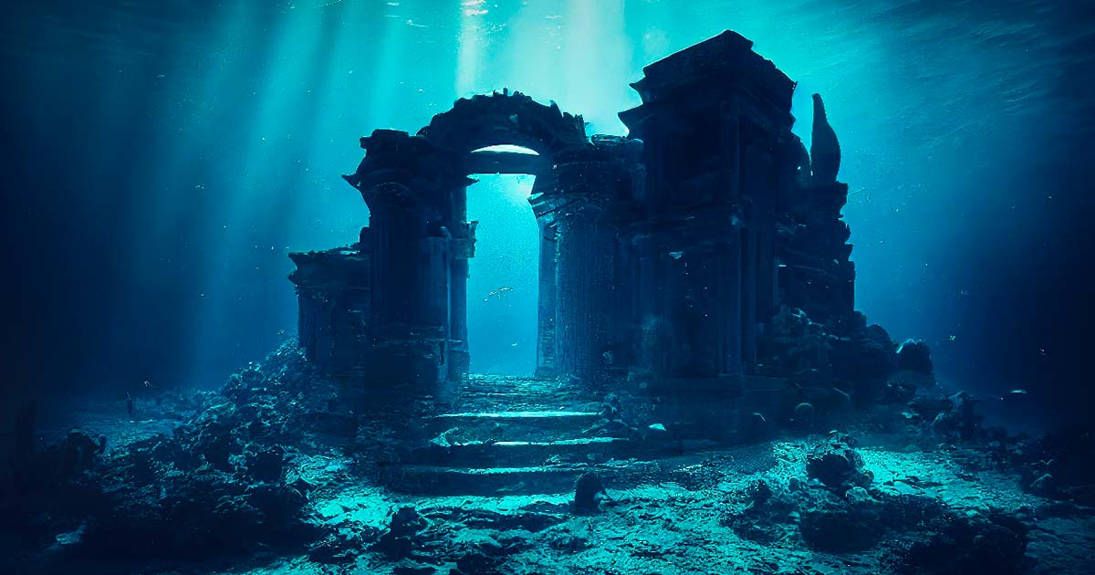

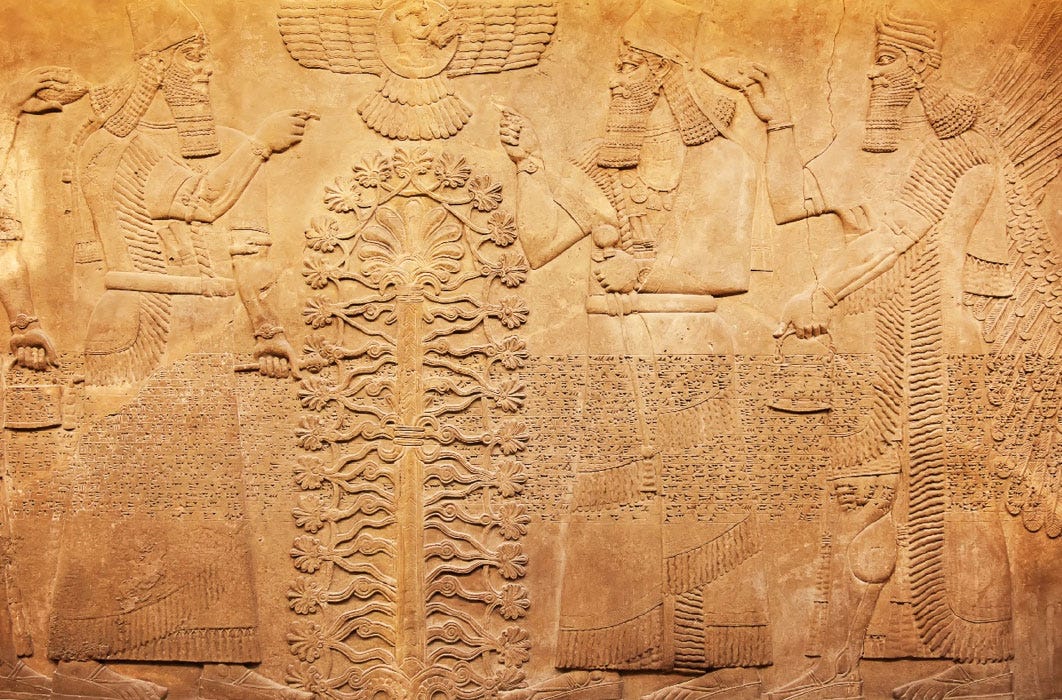
")
")
")
 (Public Domain)")
 (Public Domain)")
")
")
")

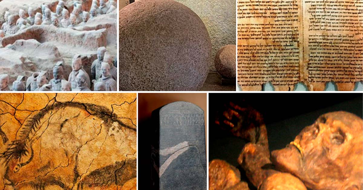
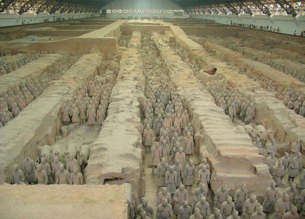
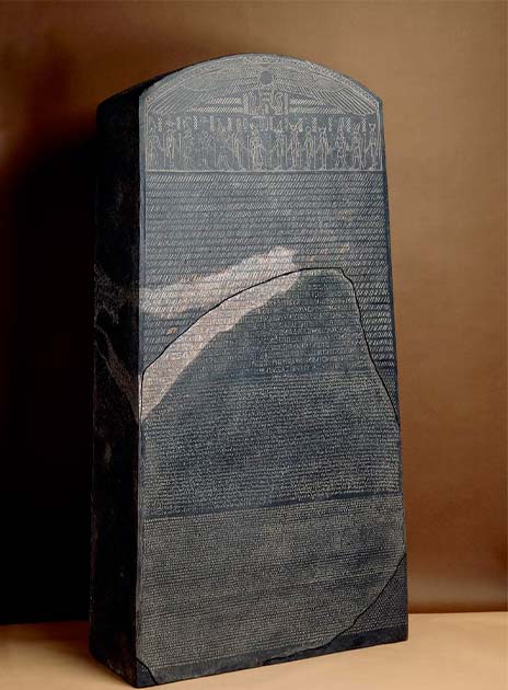
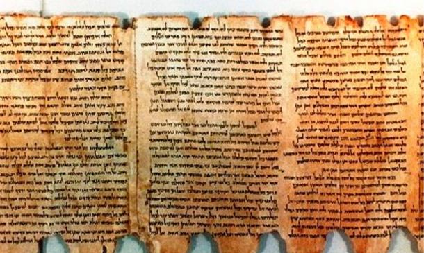
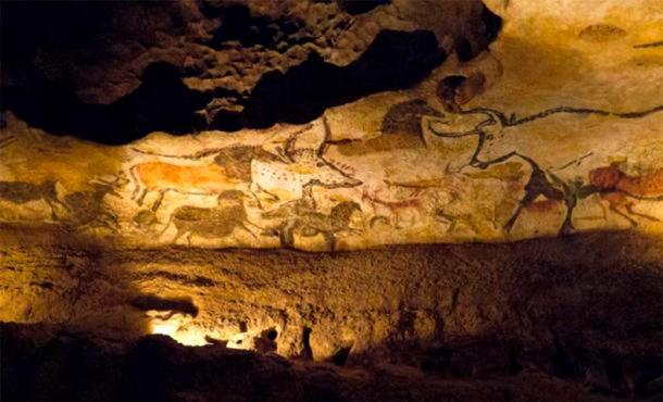
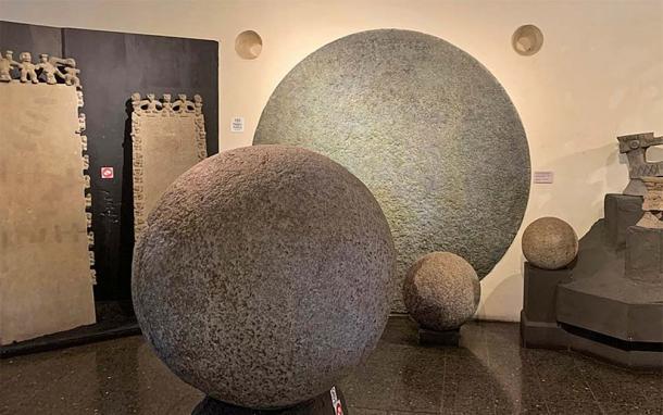
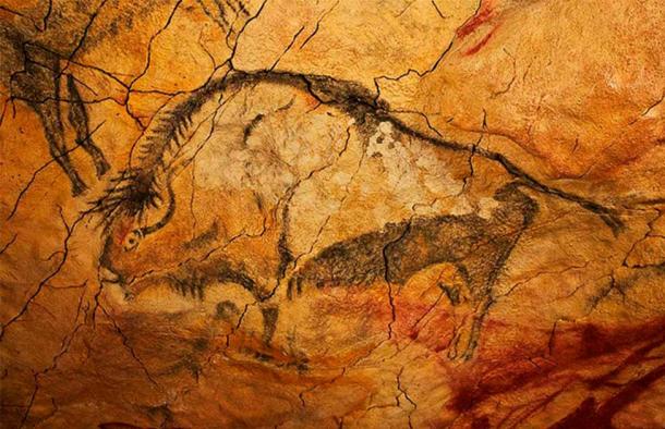
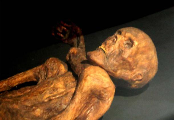

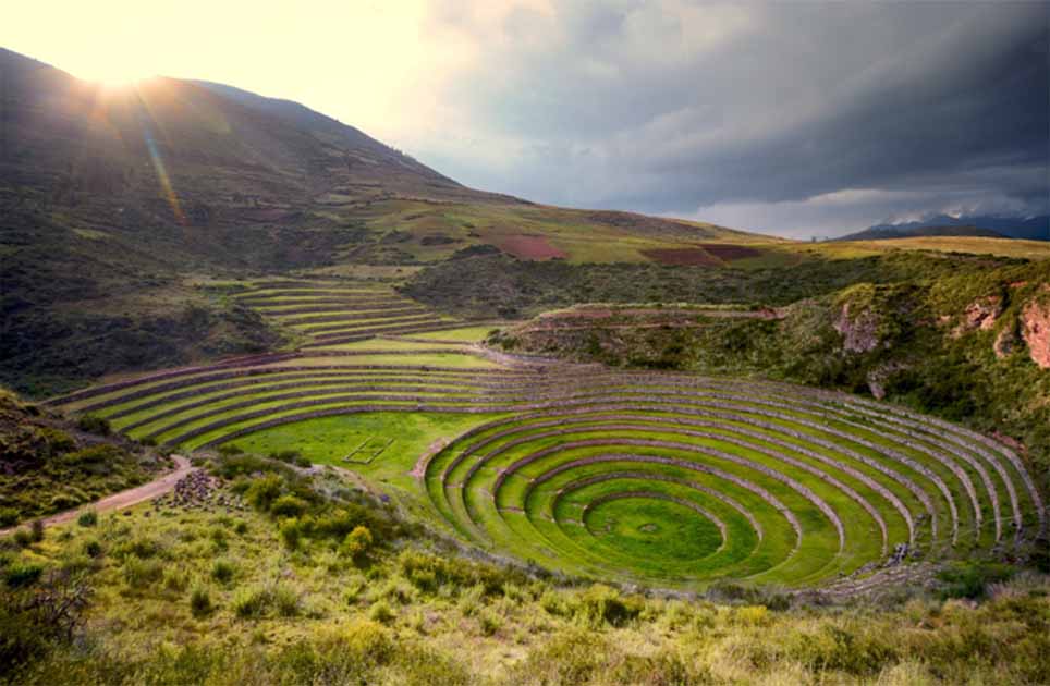
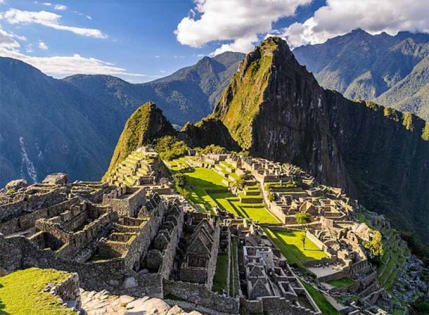
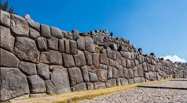
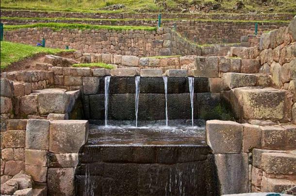
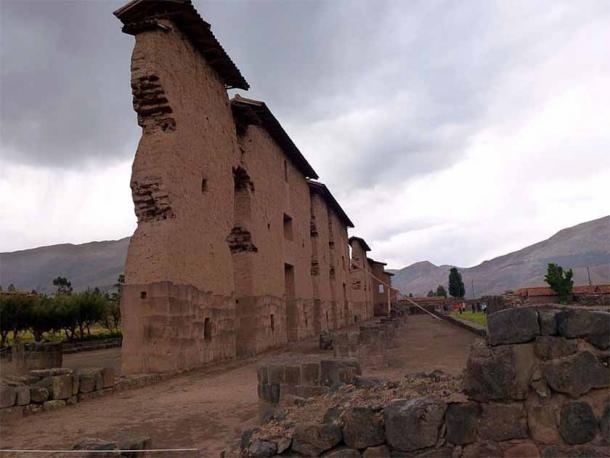
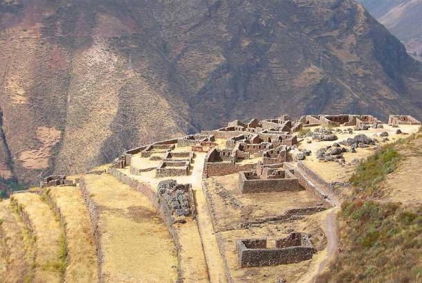
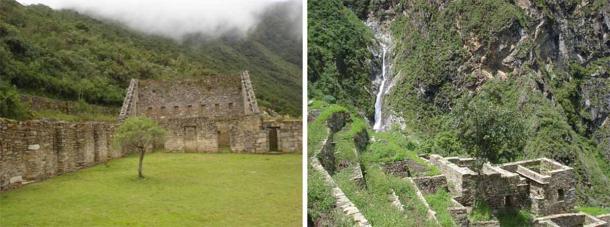
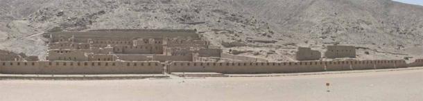
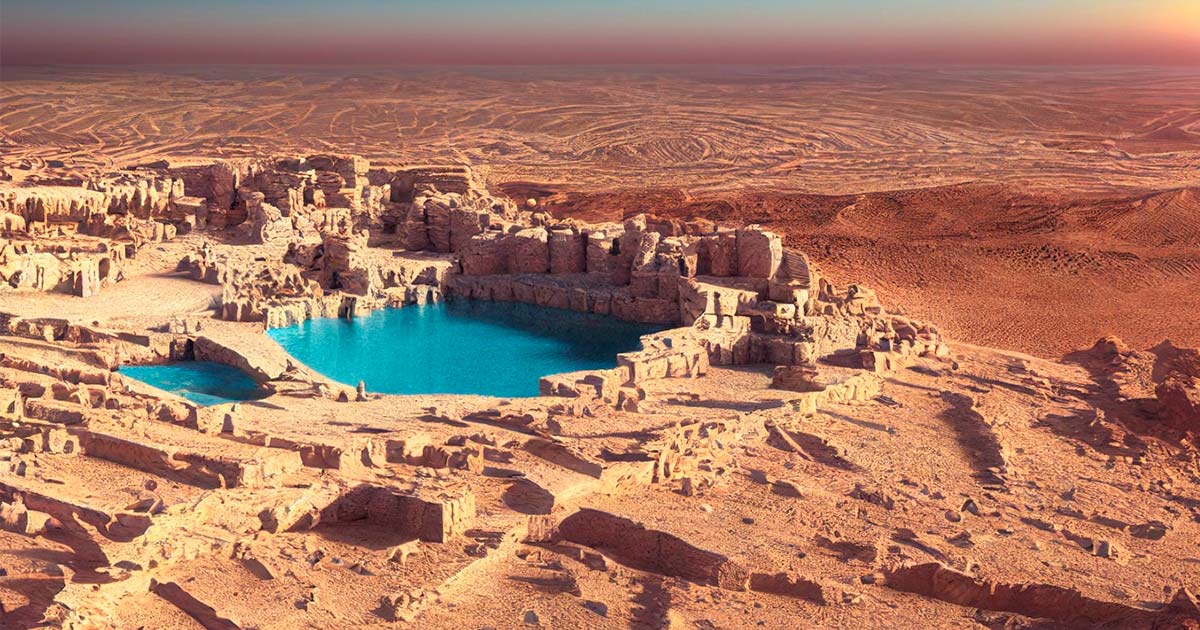

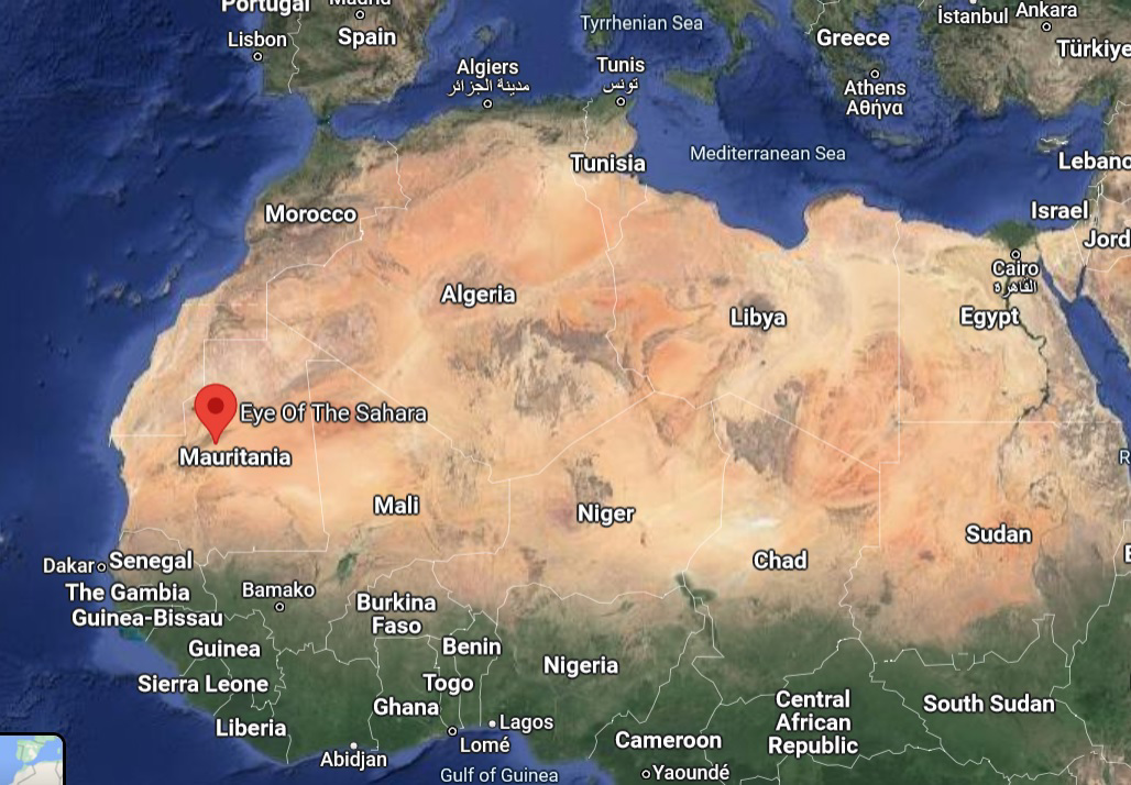
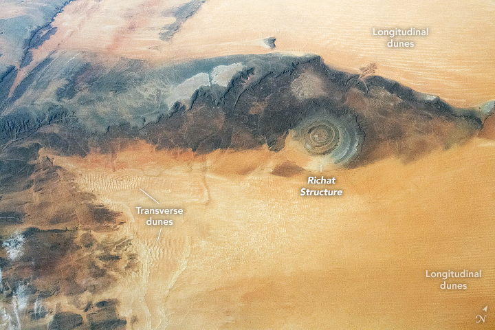
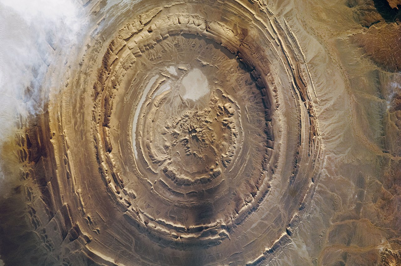
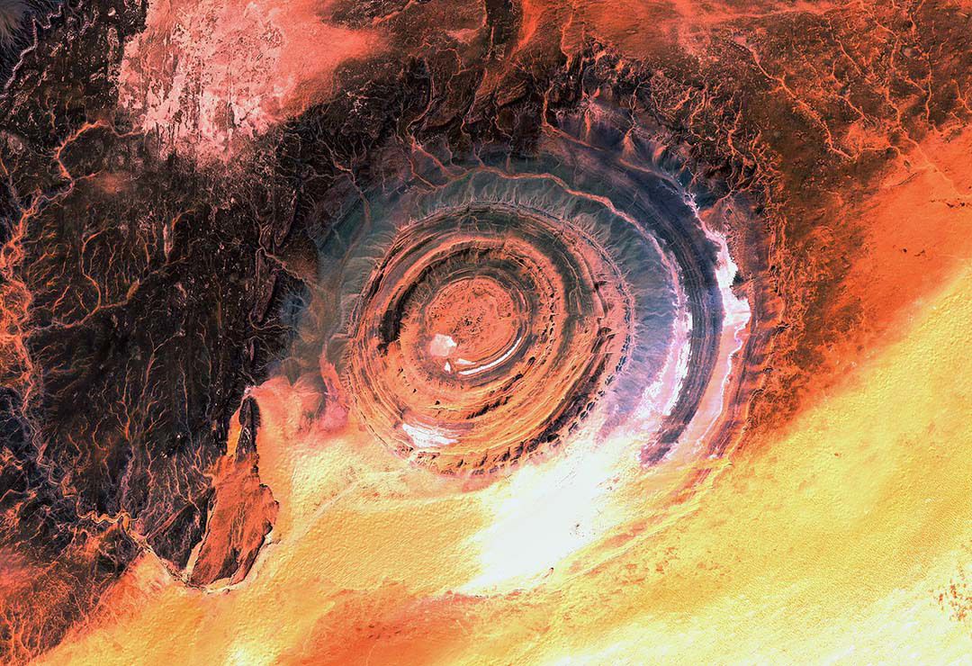
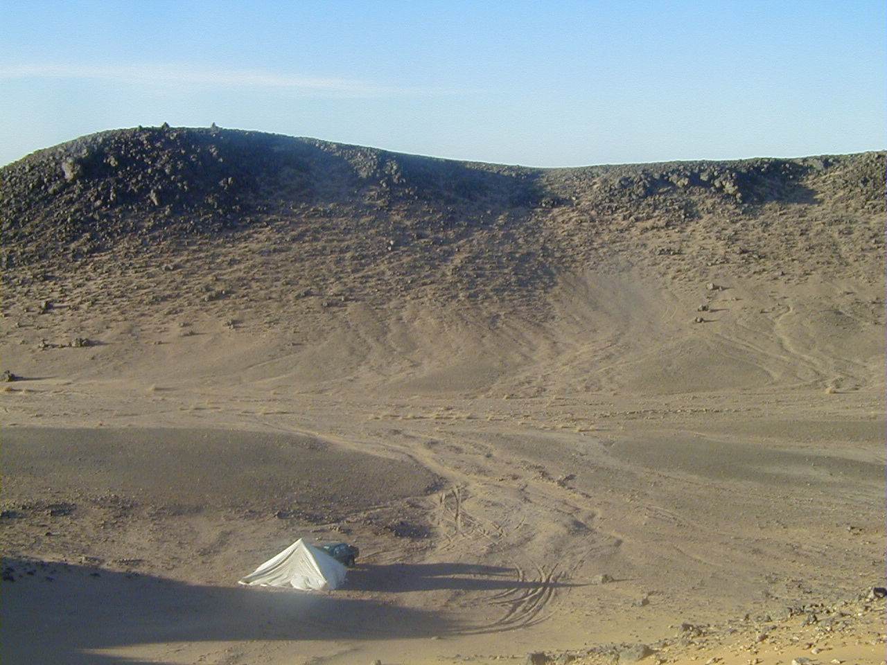
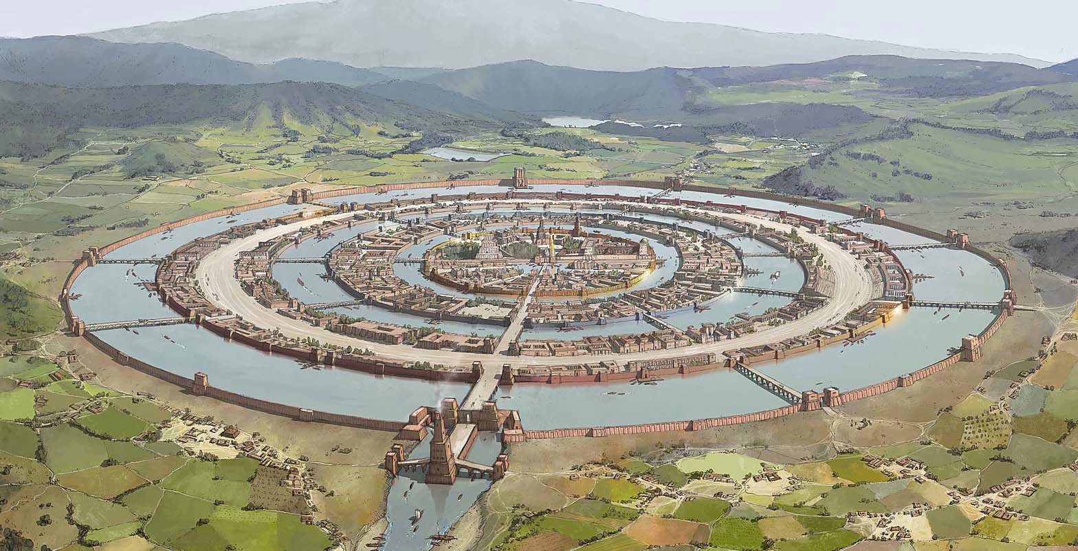
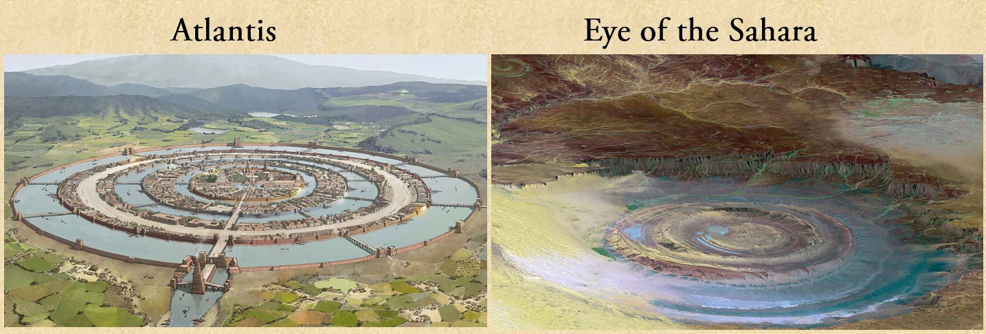
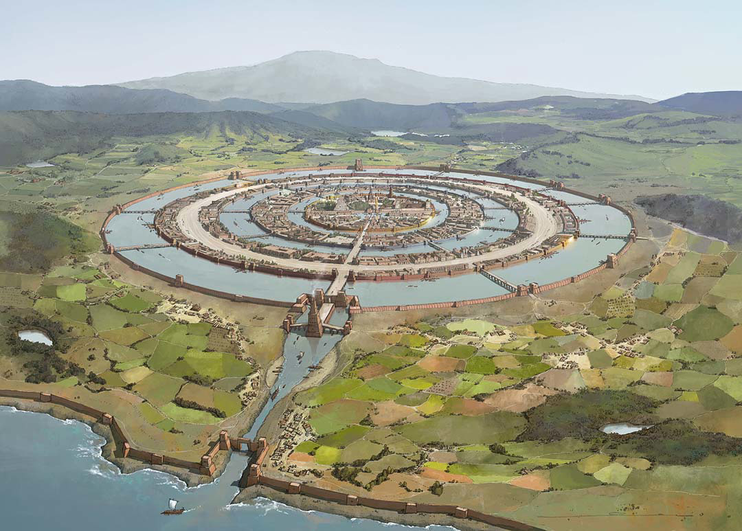
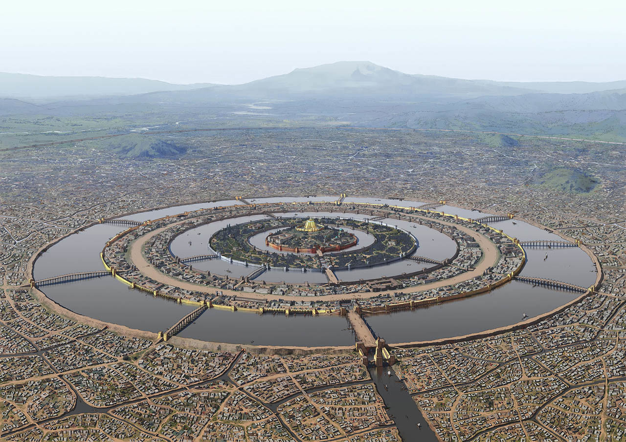
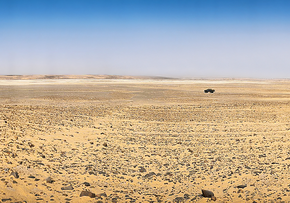
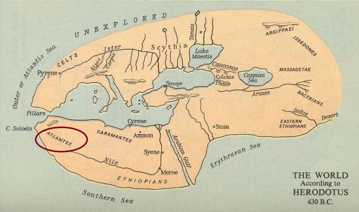
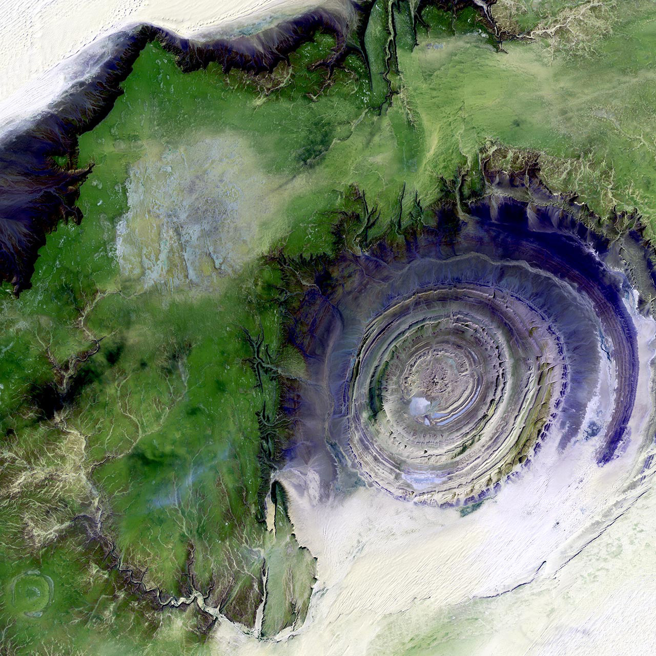
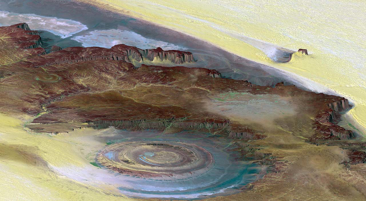

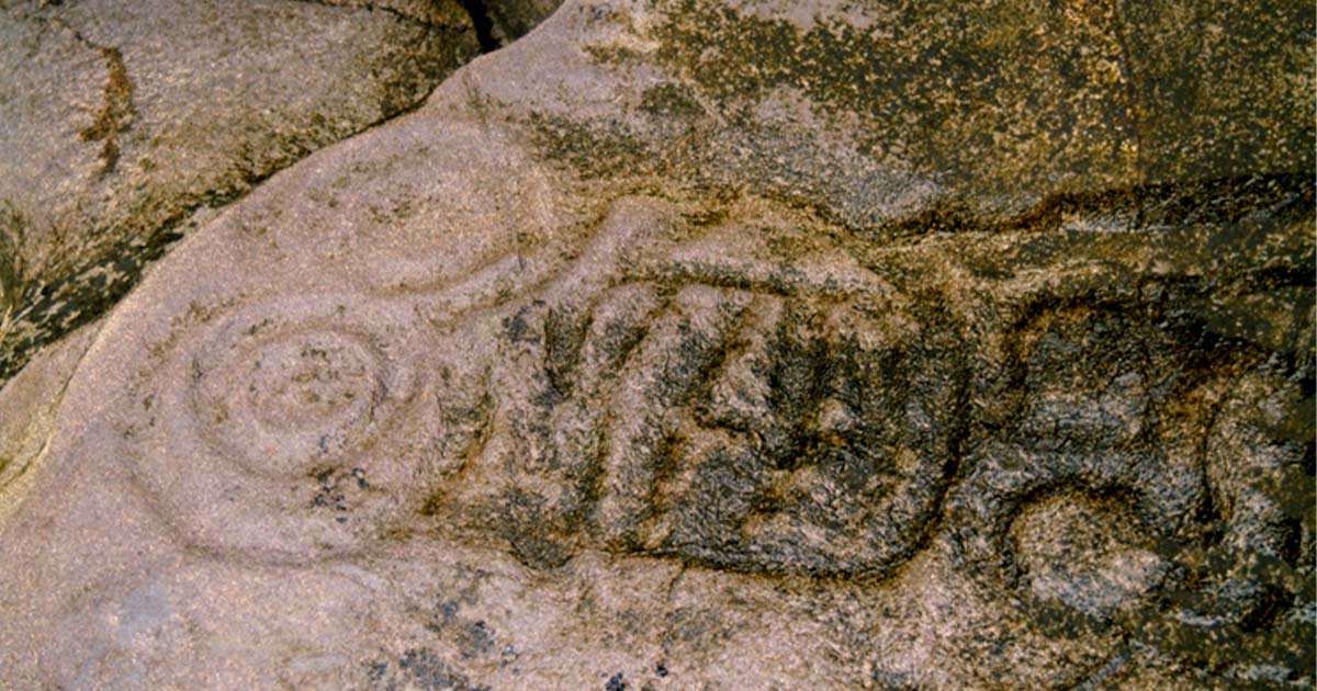
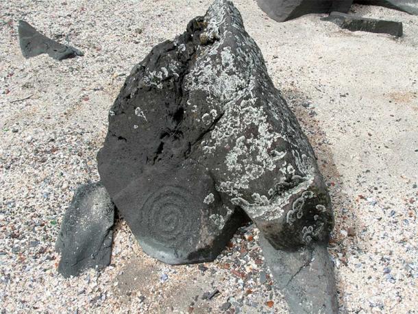
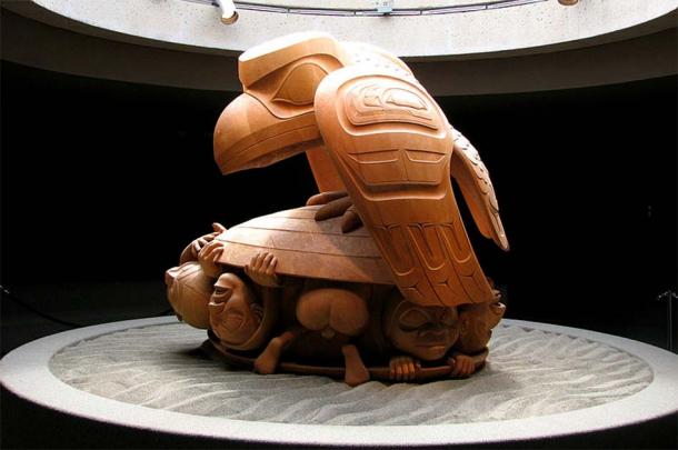


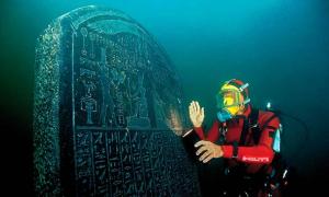
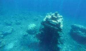


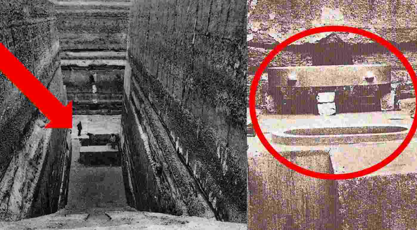
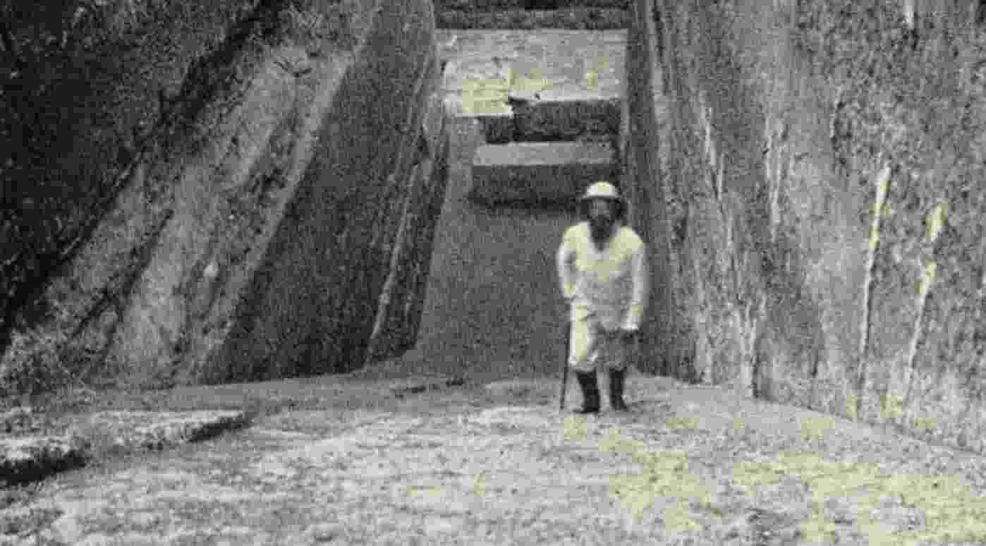
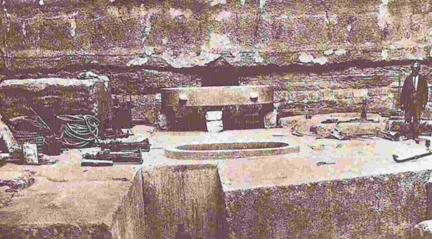
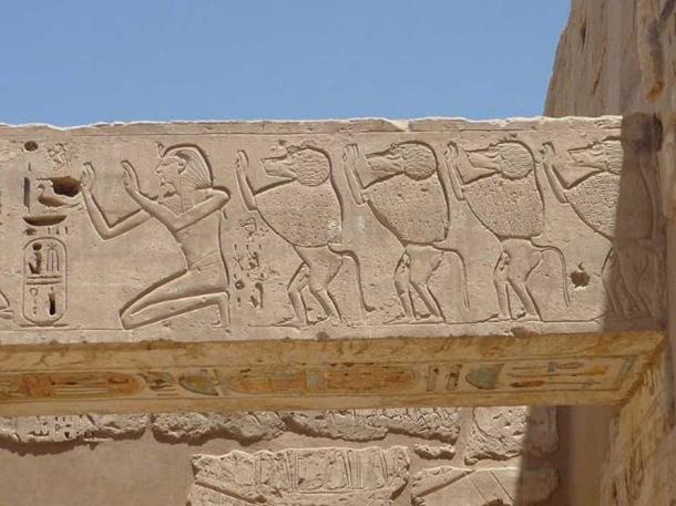
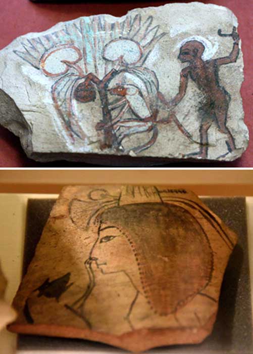
(11).jpg)


_-_EnKi_(Sumerian).jpg)
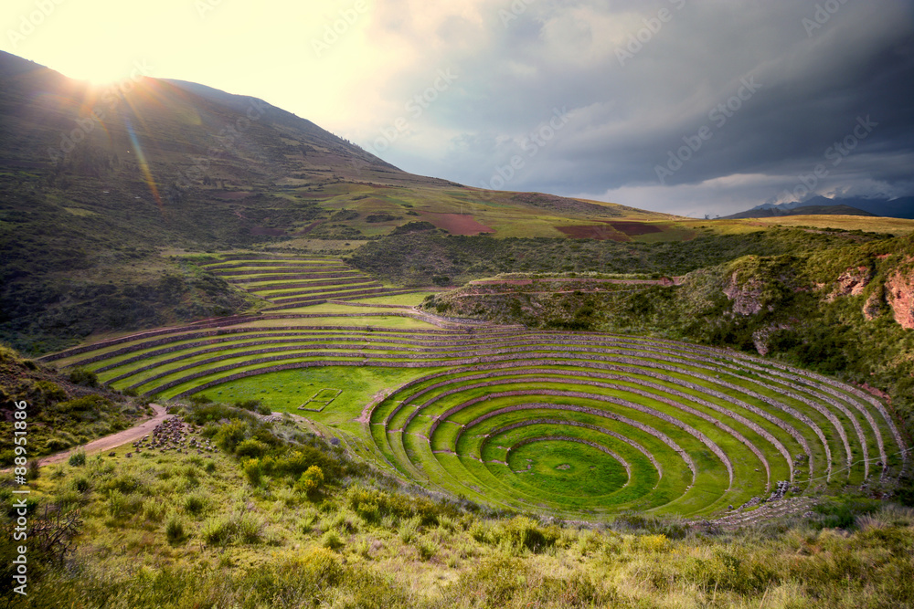