The purpose of this blog is the creation of an open, international, independent and free forum, where every UFO-researcher can publish the results of his/her research. The languagues, used for this blog, are Dutch, English and French.You can find the articles of a collegue by selecting his category. Each author stays resposable for the continue of his articles. As blogmaster I have the right to refuse an addition or an article, when it attacks other collegues or UFO-groupes.
Druk op onderstaande knop om te reageren in mijn forum
Zoeken in blog
Deze blog is opgedragen aan mijn overleden echtgenote Lucienne.
In 2012 verloor ze haar moedige strijd tegen kanker!
In 2011 startte ik deze blog, omdat ik niet mocht stoppen met mijn UFO-onderzoek.
BEDANKT!!!
Een interessant adres?
UFO'S of UAP'S, ASTRONOMIE, RUIMTEVAART, ARCHEOLOGIE, OUDHEIDKUNDE, SF-SNUFJES EN ANDERE ESOTERISCHE WETENSCHAPPEN - DE ALLERLAATSTE NIEUWTJES
UFO's of UAP'S in België en de rest van de wereld Ontdek de Fascinerende Wereld van UFO's en UAP's: Jouw Bron voor Onthullende Informatie!
Ben jij ook gefascineerd door het onbekende? Wil je meer weten over UFO's en UAP's, niet alleen in België, maar over de hele wereld? Dan ben je op de juiste plek!
België: Het Kloppend Hart van UFO-onderzoek
In België is BUFON (Belgisch UFO-Netwerk) dé autoriteit op het gebied van UFO-onderzoek. Voor betrouwbare en objectieve informatie over deze intrigerende fenomenen, bezoek je zeker onze Facebook-pagina en deze blog. Maar dat is nog niet alles! Ontdek ook het Belgisch UFO-meldpunt en Caelestia, twee organisaties die diepgaand onderzoek verrichten, al zijn ze soms kritisch of sceptisch.
Nederland: Een Schat aan Informatie
Voor onze Nederlandse buren is er de schitterende website www.ufowijzer.nl, beheerd door Paul Harmans. Deze site biedt een schat aan informatie en artikelen die je niet wilt missen!
Internationaal: MUFON - De Wereldwijde Autoriteit
Neem ook een kijkje bij MUFON (Mutual UFO Network Inc.), een gerenommeerde Amerikaanse UFO-vereniging met afdelingen in de VS en wereldwijd. MUFON is toegewijd aan de wetenschappelijke en analytische studie van het UFO-fenomeen, en hun maandelijkse tijdschrift, The MUFON UFO-Journal, is een must-read voor elke UFO-enthousiasteling. Bezoek hun website op www.mufon.com voor meer informatie.
Samenwerking en Toekomstvisie
Sinds 1 februari 2020 is Pieter niet alleen ex-president van BUFON, maar ook de voormalige nationale directeur van MUFON in Vlaanderen en Nederland. Dit creëert een sterke samenwerking met de Franse MUFON Reseau MUFON/EUROP, wat ons in staat stelt om nog meer waardevolle inzichten te delen.
Let op: Nepprofielen en Nieuwe Groeperingen
Pas op voor een nieuwe groepering die zich ook BUFON noemt, maar geen enkele connectie heeft met onze gevestigde organisatie. Hoewel zij de naam geregistreerd hebben, kunnen ze het rijke verleden en de expertise van onze groep niet evenaren. We wensen hen veel succes, maar we blijven de autoriteit in UFO-onderzoek!
Blijf Op De Hoogte!
Wil jij de laatste nieuwtjes over UFO's, ruimtevaart, archeologie, en meer? Volg ons dan en duik samen met ons in de fascinerende wereld van het onbekende! Sluit je aan bij de gemeenschap van nieuwsgierige geesten die net als jij verlangen naar antwoorden en avonturen in de sterren!
Heb je vragen of wil je meer weten? Aarzel dan niet om contact met ons op te nemen! Samen ontrafelen we het mysterie van de lucht en daarbuiten.
24-03-2026
Divers discovered a 60,000-ton stone structure underwater, and no one knows why it was built
Divers discovered a 60,000-ton stone structure underwater, and no one knows why it was built
Story by Melissa Ait Lounis
Credit: SAMM, 2023 / Yves Fouquet & al., International Journal of Nautical Archaeology | The Daily Galaxy --Great Discoveries Channel
A massive stone structure discovered beneath the Sea of Galilee is challenging archaeologists, with its purpose and age still unknown. Weighing an estimated 60,000 tons, the formation stands out as one of the largest underwater features of its kind in the region.
The structure was first detected during a 2003 sonar survey in the southwest part of the lake. Its cone-like shape and scale quickly drew attention, prompting further investigation by divers. Its proximity to known ancient sites has led scientists to explore possible links with early urban societies in the area.
Putting all the data together researchers found that the structure is cone shaped, about 230 feet (70 meters) in diameter and nearly 32 feet (10 meters) tall. It weighs an estimated 60,000 tons.
Diagram courtesy of Shmuel Marco
A Massive Cairn Made of Unworked Stone
The structure rises nearly 10 meters (32 feet) high and spans approximately 70 meters (230 feet) in diameter. According to a press release published by the International Journal of Nautical Archaeology, it is composed of unhewn basalt cobbles and boulders, some measuring up to 1 meterin length. Divers reported no evidence of cutting or shaping. The stones appear randomly arranged, without walls or clear architectural patterns.
“The boulders have natural faces with no signs of cutting or chiselling. Similarly, we did not find any sign of arrangement or walls that delineate this structure.”
Researchers describe the structure as a cairn, a type of man-made pile of stones known from other regions and sometimes associated with burial practices, though no direct evidence confirms such a use here.
Evidence Suggests a Human-Made Origin
The structure does not resemble any natural geological formation. As explained by the research team, its shape and composition point clearly to human construction.
A Sonar Survey Of Part Of The Sea In The Summer Of 2003 First Detected The Circular Structure
They propose that it was built on dry land and later submerged as the Sea of Galilee expanded. This interpretation is consistent with known environmental changes affecting the region over thousands of years. The scale of the structure implies a high level of organization. In the researchers’ view:
Scientists Discovered A Mysterious Ancient City Hidden Underwater That Shouldn't Exist
“This is such a huge structure that it truly is something unusual. It could have been a big ceremonial structure, or a ramp. There could have once been statues on top of people in certain rituals. I mean, I’m really going wild here. The truth is we don’t know how it was constructed, what its exact age is, how it was used, or how long ago it was used. We have several speculations, but we don’t know much except that it’s there and it’s huge.”
A Lost Bronze Age Link
Archaeologist Yitzhak Paz, from the Israel Antiquities Authority and Ben-Gurion University, saidthat the stone structure may date to the third millennium B.C.. He noted that similar megalithic phenomena have been identified in nearby areas.
One example cited in the study is Khirbet Beteiha, located about 30 kilometers to the northeast, which features concentric stone circles. These parallels suggest the underwater structure could belong to the same cultural context.
If this dating is confirmed, the structure would have been located near Bet Yerah (or Khirbet Kerak), a major settlement of the time. ArchaeologistRaphael Greenberg noted that the city covered 30 hectares and had up to 5,000 inhabitants, with fortified defenses and organized urban planning.
No underwater excavation has yet been carried out, leaving the structure’s function and exact age uncertain.
“If the site was inland, it would be much easier to investigate. By now we would have excavated, but because it’s submerged we haven’t yet been able to. It is a much harder process, both physically and financially. It is very expensive to raise support for such an enterprise,” noted Yitzhak Paz.
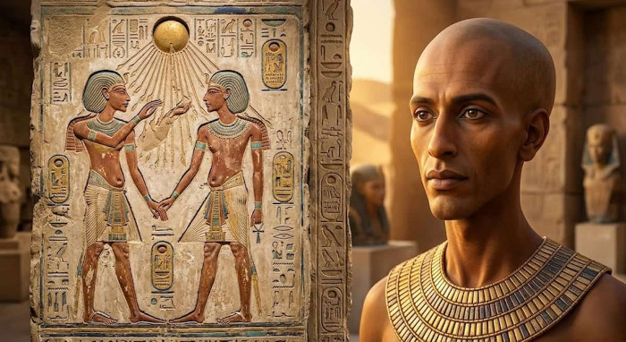
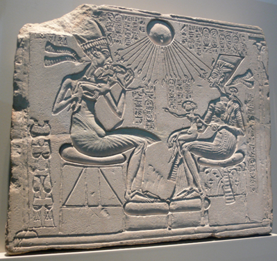
The Amarna Anomaly: Did Akhenaten’s DNA Carry the Signature of the Gods?
The Amarna Anomaly: Did Akhenaten’s DNA Carry the Signature of the Gods?
When Amenhotep IV ascended the throne in the 14th century BC, he was not meant to be king. The unexpected death of his older brother thrust him into power, and within a few short years, he changed his name to Akhenaten, meaning "effective for the Aten." He moved the capital to a new, isolated city in the desert, Akhetaten (modern Amarna), and declared himself the sole intermediary between humanity and the divine. Even today, researchers debate whether the ancient Egyptian Akhenaten plague may have been a historical myth designed to explain the sudden abandonment of this utopian city.
But it is the art of the Amarna period that has left the most indelible mark on history. Unlike the idealized, rigid, and muscular depictions of previous pharaohs, Akhenaten ordered his artisans to portray him and his family exactly as they were. The result was a shocking departure from tradition. Statues and reliefs show the pharaoh with a mix of masculine and feminine traits, including visible gynecomastia (breast tissue) and a distended belly. His wife, whose fate remains tied to the mysterious disappearance of Nefertiti and their daughters, was also depicted with dramatically elongated skulls.
llustration of the more realistic art of the Amarna period.
According to a comprehensive 2025 medical review published in the Journal Cureus, experts have proposed numerous diagnoses to explain these features, ranging from Marfan syndrome to aromatase excess syndrome and Klinefelter syndrome. Marfan syndrome, a genetic disorder affecting connective tissue, could explain the elongated face and spindly limbs, but it does not account for the female characteristics. Conversely, aromatase excess syndrome could explain the gynecomastia, but it falls short of explaining the cranial deformities. The study ultimately concluded that while these medical theories are fascinating, it is highly unlikely that a single disease could account for the entirety of the Amarna royal family's bizarre physiques.
The Secret of Tomb KV55
The mystery deepened in 1907 when archaeologists discovered a small, unassuming tomb in the Valley of the Kings, designated KV55. Inside, they found a desecrated coffin. The golden face mask had been violently ripped away, and the cartouches bearing the occupant's name were chiseled out, a deliberate act of damnatio memoriae intended to erase the individual from the afterlife.
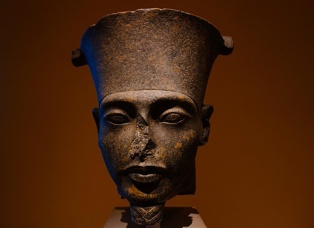
A striking close-up of a dark stone bust depicting Pharaoh Akhenaten, showcasing the distinctive elongated facial features and the tall crown of the 18th Dynasty.
For over a century, the identity of the KV55 mummy was fiercely debated. Was it Queen Tiye, the enigmatic Smenkhkare, or Akhenaten himself? In 2010, a landmark DNA study published in the Journal of the American Medical Association (JAMA) provided a stunning revelation. Genetic fingerprinting of the royal mummies confirmed that the KV55 skeleton was the father of King Tutankhamun and the son of Amenhotep III. By all genealogical accounts, this was the heretic king, Akhenaten, finally unmasking the identity of the controversial mummy KV55.
However, the physical examination of the KV55 skeleton presented a glaring paradox. The bones did not show the extreme deformities depicted in the Amarna art. There was no evidence of severe craniosynostosis (premature fusing of the skull bones) or the skeletal markers of Marfan syndrome. This has led many mainstream historians to conclude that the Amarna art style was purely symbolic, a propagandistic choice to depict the pharaoh as the "mother and father of all mankind," reflecting the androgynous nature of the Aten itself.
What if this conclusion is missing the larger picture? What if the art was not an exaggeration, but a deliberate homage to an ancestral truth that the pharaoh was trying to resurrect?
The Signature of the Gods
To understand the Amarna anomaly, one must look beyond the confines of traditional Egyptology and into the broader mythos of the ancient world. Across various ancient cultures, from the Sumerian texts of Mesopotamia to the biblical accounts of the Nephilim, there are persistent records of "Watchers" or "gods" who descended from the heavens and mingled their seed with humanity.
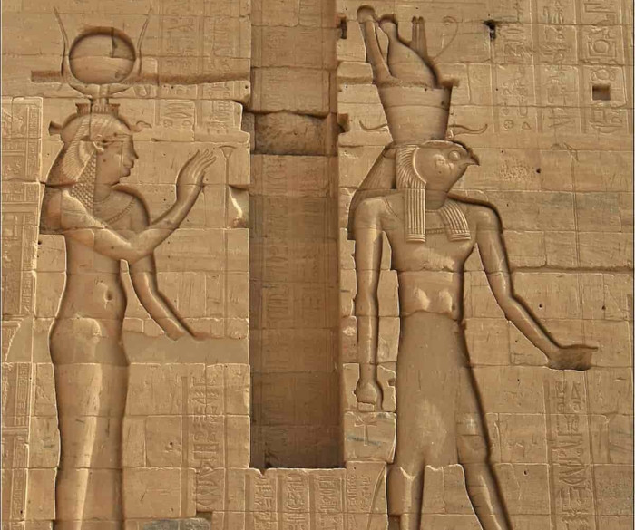
Ancient Egyptian relief at a temple complex, showcasing the monumental scale and detailed hieroglyphic carvings of the Amarna period.
Akhenaten’s religious revolution was not just about monotheism; it was about direct, unmediated contact with the divine. The Aten was not a human-like god; it was depicted as a celestial disc extending rays of light that ended in hands, offering the ankh (the breath of life) directly to the royal family. Akhenaten bypassed the traditional priesthoods because he claimed a direct, biological, and spiritual link to this celestial force.
If we view the Amarna period through the lens of ancient hybridization narratives, the physical anomalies of Akhenaten and his family take on a new meaning. The elongated skulls, the androgynous features, and the bizarre proportions may not have been the result of a random genetic disease, but rather the manifestation of a dormant, ancient gene, the biological blueprint of the "gods" from the First Time (Zep Tepi).
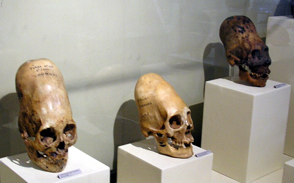
Elongated skulls on display at Museo Regional de Ica in the city of Ica in Peru.
This theory aligns with the global phenomenon of artificial cranial deformation, practiced by cultures from the Americas to the Black Sea. Why would disparate, unconnected ancient societies deliberately bind the heads of their infants to achieve an elongated shape? The most logical conclusion is that they were imitating a ruling elite or a "divine" race that naturally possessed these cranial features. Akhenaten and his daughters may have been the last visible resurgence of this authentic, un-deformed genetic lineage in the ancient Near East.
The Institutional Silence
The debate over Akhenaten’s DNA and his physical form is not just an academic exercise; it touches upon the sensitive issue of how history is curated. Just as the successor pharaohs, including Horemheb and even Akhenaten’s own son, Tutankhamun, systematically smashed the Amarna statues and erased the heretic’s name from the king lists, modern institutions have often been accused of downplaying discoveries that challenge the established narrative of human origins.
While there is no direct evidence of a modern "cover-up" regarding the KV55 mummy, the intense resistance within orthodox academia to entertain theories outside of standard medical diagnoses reflects a broader reluctance to engage with the uncomfortable anomalies of our past. The 2010 DNA results were groundbreaking, yet they left many questions unanswered, particularly regarding the exact nature of the genetic markers found within the 18th Dynasty lineage.
The Legacy of the Heretic
Akhenaten’s reign was a brief, blinding flash of radical departure in the long, conservative history of ancient Egypt. He attempted to pull his civilization back to a purer, more direct connection with the cosmos, bypassing the corrupt human institutions of the priesthood. In doing so, he may have revealed the true, hidden face of the ancient rulers, a face that was deliberately obscured by those who came after him.
House altar Akhenaten Nefertiti Berlin showing Akhenaten, Nefertiti and three of their daughters. (Egyptian Museum of Berlin/Public domain)
The Amarna anomaly remains one of the most compelling mysteries of antiquity. Whether viewed as a tragic medical case study, an alternative view of the heretic king, or the startling re-emergence of a divine genetic blueprint, Akhenaten continues to challenge our understanding of who we are and where we came from. As science advances and our ability to sequence ancient DNA improves, the sands of Egypt may yet yield the final truth about the bloodline of the gods.
Deep Dive
The Global Elongated Skull Phenomenon: The practice of artificial cranial deformation was widespread in antiquity, from the Paracas skulls of Peru to the Huns of the Eurasian steppes. Many alternative researchers argue that this painful practice was an attempt by human elites to mimic the natural physiology of a "god-like" ruling class, of which the Amarna royals may have been a late manifestation.
The Damnatio Memoriae: The erasure of Akhenaten was so thorough that his existence was completely forgotten until the 19th century. His city of Akhetaten was abandoned and swallowed by the desert, preserving the unique art and boundary stelae that eventually allowed archaeologists to piece together the story of the pharaoh who tried to change the universe.
More Fast Facts
Medical Mystery or Divine Blueprint? The elongated skulls, spindly limbs, and androgynous features of Pharaoh Akhenaten and his family have baffled experts for over a century, with recent medical studies struggling to pinpoint a single human disease that explains all their physical anomalies.
The KV55 Controversy: DNA analysis from 2010 identified the desecrated mummy in Tomb KV55 as the likely father of Tutankhamun and the heretic king Akhenaten himself, but the lack of severe physical deformities in the skeleton has only deepened the mystery of the Amarna art style.
The golden sands of Egypt hold many secrets, but few are as enduring or as controversial as the mystery of the Amarna period. Over 3,300 years ago, a radical pharaoh upended seventeen centuries of religious tradition, plunging the most powerful empire in the ancient world into chaos. He abolished the powerful priesthoods, erased the names of the old gods, and established the worship of a single, faceless deity, the Aten. But it was not just his religious revolution that shocked subsequent generations; it was the bizarre, almost otherworldly physical appearance of the pharaoh himself.
Akhenaten, the "Heretic King," was depicted with a severely elongated skull, a long sinewy neck, a narrow upper torso, broad hips, and spindly limbs. For decades, Egyptologists and medical professionals have debated whether these depictions were mere artistic stylization or the result of a profound genetic mutation. Yet, as modern science attempts to retroactively diagnose this ancient ruler, a more profound question emerges: Could the physical anomalies of the Amarna royals be a reflection of a much older, divine bloodline, a genetic signature from the "first time" of the gods?
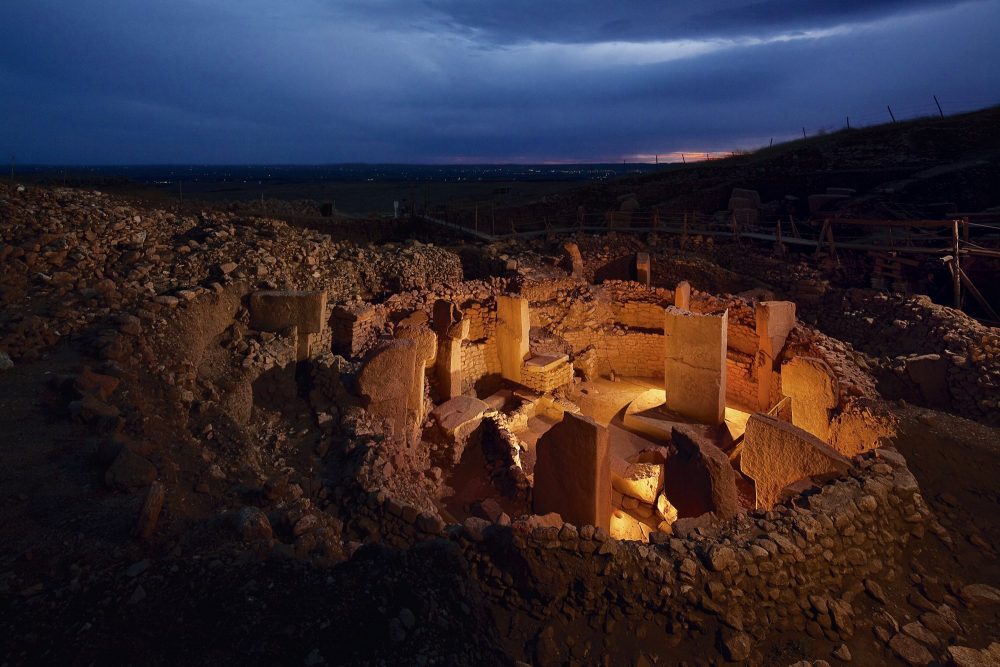
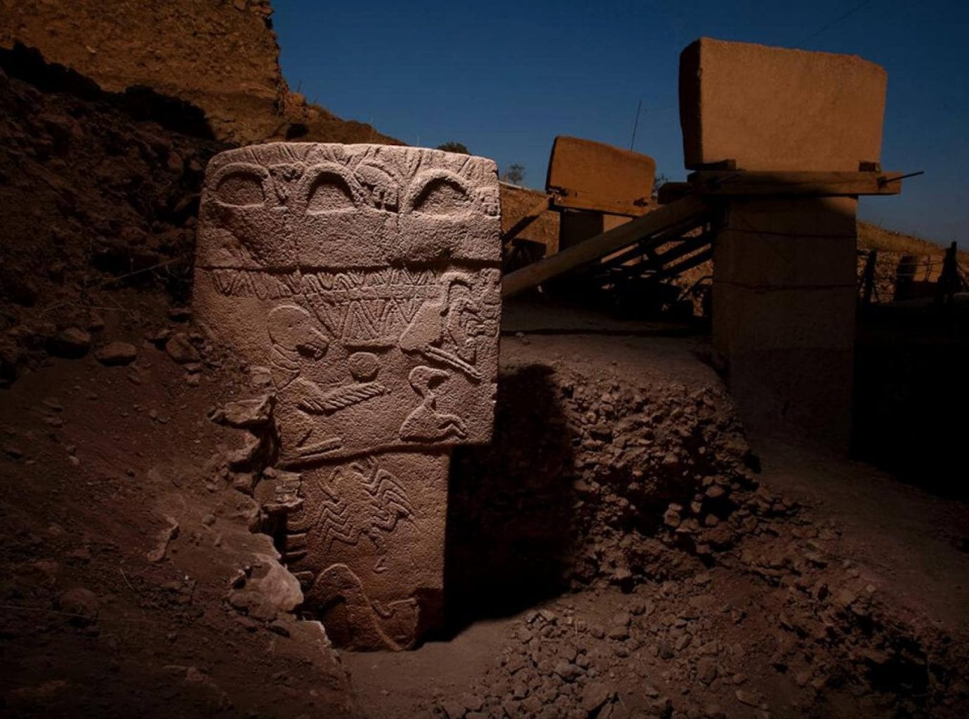
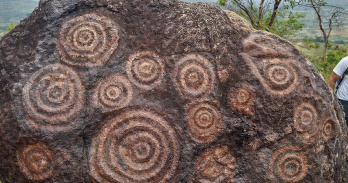
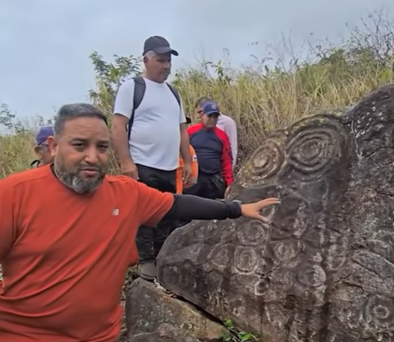
Israel’s strange Wheel of Ghosts, first discovered in 1968, turns out not to be so unusual after all, as new research combining remote sensing and AI now confirms the presence of many similar sites in the region.
Situated in the Golan Heights and composed of 40,000 tons of rock, archaeologists estimate the structure to date back between 3,500 and 6,500 years. Commonly referred to as the “Stonehenge of the East,” the site’s official name is Rujm el-Hiri, and it is cast in a decidedly new light in a recent paper published in PLOS One, revealing many similar structures.
Interpreting the Wheel of Ghosts
Existing interpretations have diverged in their explanations of what the Wheel of Ghosts meant to the people who built it. Those explanations run the gamut of what is generally assumed of these mysterious ancient sites: a ceremonial space, a burial mound, or an astronomical observatory.
However, these interpretations all relied on a major assumption that has proven false: that the Wheel of Ghosts is unique to the area.
That basic assumption has now been turned on its head by an international multidisciplinary team of physicists and archaeologists. Their work was rooted in remote sensing, a broad category of tools that have allowed archaeologists to view areas at broad scales, and even image beneath the ground. While such technologies have long existed, their increased adoption among archaeologists has led to major discoveries in the last two decades.
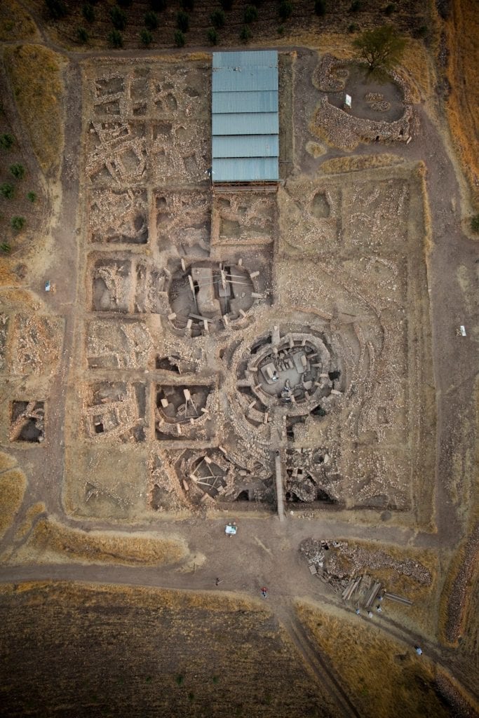
Newly discovered sites surrounding the Wheel of Ghosts maintained the round motif of the original. Credit: M. Birkenfeld
The Satellite View
Data for the research came from archives containing multiple satellite imagery platforms, including Google Earth Pro and CNES/Airbus. These archives held two decades of imagery captured between 2004 and 2024, providing multiple observations of the same regions over the years. Processing those images and then performing a comparative analysis helped the team to uncover these new sites.
Through AI processing, obscuring features like shadows and seasonal vegetation were mitigated, revealing features otherwise impossible to discern. These included signs of ancient human intervention, along with other notable landscape features, which were typically obscured. The team noted that this is a major boon to archaeology, alleviating the need for expensive, time-consuming expeditions to regions that may contain nothing of interest.
In the AI-processed imagery, researchers uncovered new sites resembling the wheel of Ghosts.
Credit: A. Kleiner
Uncovering Further Wheel of Ghosts-Like Sites
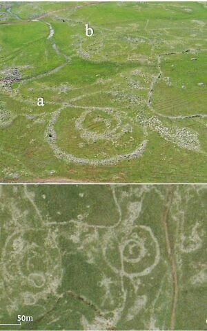
During their research, the team was shocked to find 28 sites resembling the Wheel of Ghosts, all of which had remained hidden in the area. These large, round structures shared many of the characteristics with Rujm El-Hiri and were all situated within a tight 16-mile radius of the site.
Amid the new discoveries, the Wheel of Ghosts remains singular in terms of its quality. Other sites were smaller, less elaborate, and more heavily degraded. This is likely why they remained undetected for almost six decades after the Wheel of Ghosts was first identified by modern archaeologists.
One of the primary impediments to clearly understanding the original site and these additional newly discovered structures is the broad time range archaeologists attribute to the original’s construction. This makes it difficult to determine exactly which group of people inhabited the area at the time, further clouding what these structures may have been intended for.
Aerial views of Circles 11(a) and 12 (b) identified in a survey conducted by remote sensing and published in the PLOS ONE journal on March 18, 2026. (Aerial imagery provided by the survey of Israel (MAPI)- used with permission. Upper photo by A. Wiegman. Prepared by M. Birkenfeld and U. Berger)
Intriguingly, while there seems to be a clear group of similar structures in this region, sites farther away in Galilee and Lebanon also resemble the Wheel of Ghosts in the new research. Tying together all of these sites, both near and far, will now require extensive on-the-ground research to determine if they were all occupied by a single culture
Ryan Whalen covers science and technology for The Debrief. He holds an MA in History and a Master of Library and Information Science with a certificate in Data Science. He can be contacted at ryan@thedebrief.org, and follow him on Twitter @mdntwvlf.
A discovery made more than two decades ago by Canadian marine engineers Paulina Zelitsky and Paul Weinzweig has resurfaced in recent discussions, sparking renewed interest and controversy. In 2001, while conducting an expedition to map the ocean floor near Cuba, the pair uncovered what they believed to be the remains of a long-lost city submerged over 2,000 feet underwater. The sonar scans revealed structures resembling pyramids, roads, and other buildings that suggested a sophisticated urban center. According to the DailyMail, this submerged city is believed to be more than 6,000 years old, potentially older than the Egyptian pyramids, and its discovery could reshape human history. However, since the initial findings, the site has been largely ignored, leaving many unanswered questions. The discovery has triggered debates about its authenticity, with experts divided on whether the site is a natural formation or evidence of an ancient civilization.
The Discovery: A Sunken City or Natural Formations?
When Zelitsky and Weinzweig first reported their findings, they described the structures as potential evidence of an advanced urban center that had been submerged beneath the sea over 6,000 years ago. The sonar scans revealed what appeared to be multiple pyramids and other carefully designed buildings. According to Zelitsky, “It’s a really wonderful structure which really looks like it could have been a large urban center.” With such a remarkable discovery, the team believed that the site could significantly alter our current understanding of human civilization.
However, the initial excitement soon gave way to skepticism from other scientists. One of the primary challenges to the authenticity of the discovery is the location itself: the structures are located over 2,000 feet underwater, far deeper than one might expect for a city that could have been submerged merely thousands of years ago. Skeptics argue that it would have taken much longer—possibly tens of thousands of years—for the area to sink to its current depth due to shifting tectonic plates.
“It would be totally irresponsible to say what it was before we have evidence,” Zelitsky added in a 2001 interview with the BBC, highlighting the complexity of interpreting the findings without more substantial data. Despite the initial reports, no follow-up research has been conducted to gather more concrete evidence to either confirm or debunk the theory that the site was an ancient city.
Sonar scans uncovered massive stone structures on the seabed near the Guanahacabibes Peninsula, resembling pyramids, circular formations, and large blocks.
Credit: ADC via Morien Institute.
Skepticism from Experts: Could the Structures Be Natural?
Among the loudest voices of skepticism is Cuban geologist Manuel Iturralde-Vinent, who has repeatedly dismissed the claim that the structures are man-made. “It’s strange, it’s weird; we’ve never seen something like this before, and we don’t have an explanation for it,” Iturralde told The Washington Post, acknowledging the unusual nature of the discovery, but also stressing the need for caution in interpreting the findings.
Iturralde and other experts have pointed out that the underwater formations could very well be the result of natural geological processes rather than the work of ancient civilizations. According to these critics, the regularity of the formations and their apparent symmetry could be coincidental, and not necessarily indicative of an artificial construction. Given the depth at which the ruins were found, some researchers suggest that the ocean currents and tectonic activity in the area might have shaped the stones in ways that mimic human-made structures.
The debate over the true nature of the site continues to rage, with some proposing that the discovery might be more evidence of ancient civilizations that were once lost to history, while others contend that the site is simply an odd but natural formation. The lack of conclusive evidence has led to an ongoing divide in the scientific community.
A Global Debate: Could This City Rewrite Human History?
While the mystery of the Cuban underwater city remains unsolved, it brings to the forefront one of the most intriguing questions in archaeology: How far back do human civilizations truly date? If the submerged ruins are indeed evidence of an ancient city, it could rewrite the conventional understanding of human history and civilization. Many believe that the discovery, if confirmed, would challenge the currently accepted timeline of human development, suggesting that advanced urban centers existed long before the Egyptians.
Michael Faught, a specialist in underwater archaeology at Florida State University, was among the experts expressing doubt about the authenticity of the ruins. “It would be cool if Zelitsky and Weinzweig were right, but it would be really advanced for anything we would see in the New World for that time frame. The structures are out of time and out of place,” Faught told the South Florida Sun-Sentinel, referencing the complexity of the structures that would have been unprecedented in the Americas at the time.
Despite these doubts, the possibility of rewriting human history remains an enticing prospect for many. Archaeological discoveries like Göbekli Tepe in Turkey, which predates the Egyptian pyramids by over 5,000 years, challenge our understanding of early human societies and their capabilities. Could the Cuban ruins be part of a similar, yet still undiscovered, civilization?
These two ancient civilizations were separated by thousands of kilometers.
Archaeologists report motifs in Honduras that resemble Neolithic Chinese symbolism, raising questions about deep shared roots rather than contact.
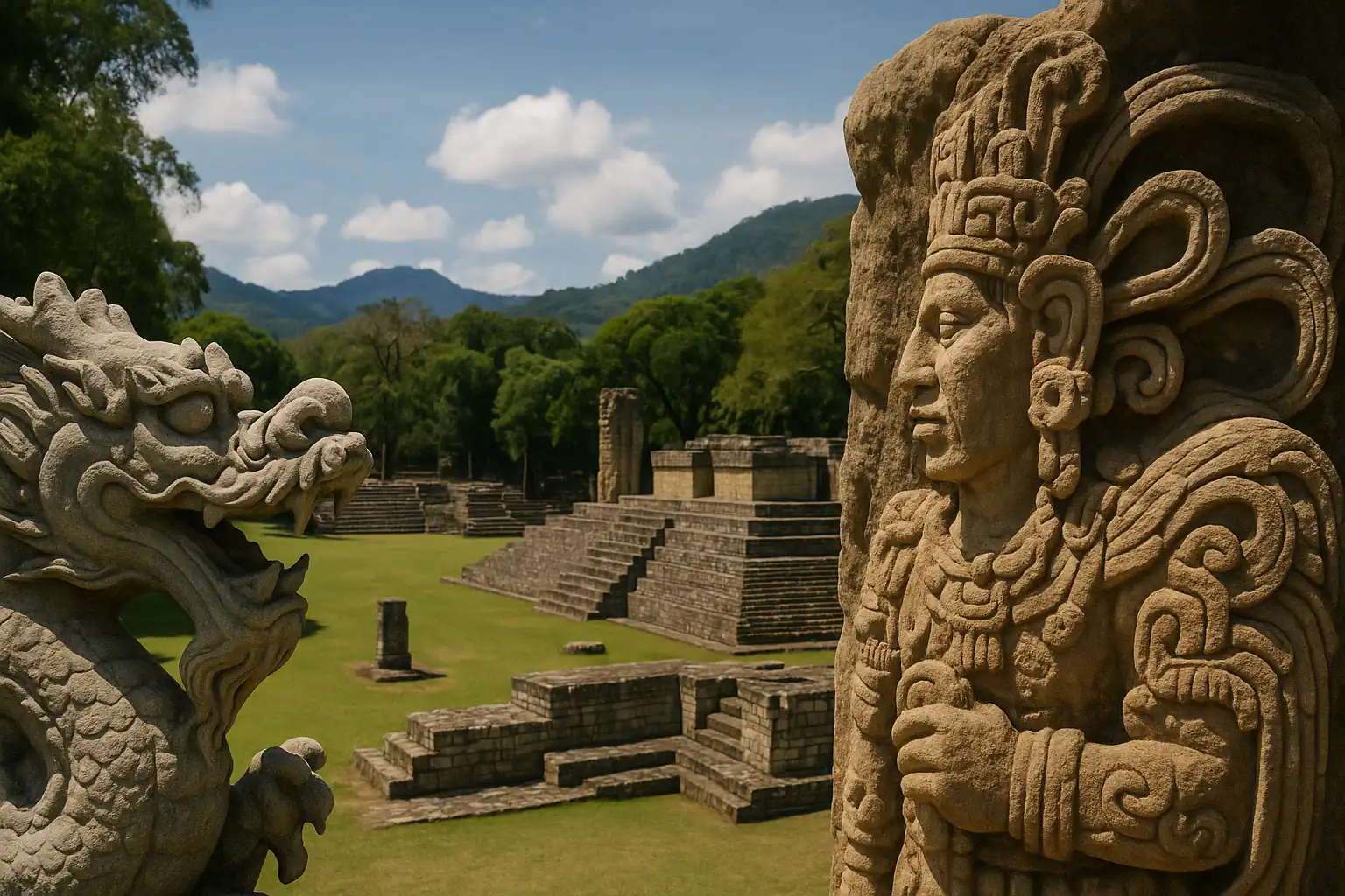
Archaeological work at Copán, the ancient Maya city in present-day Honduras, has revived an old debate about why distant civilizations sometimes produce familiar-looking symbols. A Chinese archaeological team working at the site has identified sculptures and architectural features that they say resemble elements associated with China’s Neolithic Liangzhu Culture.
The similarities have prompted renewed interest in whether shared ideas might have very deep origins, reaching back long before either civilization existed in its recognizable form. The claims, as described by researchers involved, are not framed as evidence that people crossed oceans to exchange beliefs or art. The argument is narrower and more speculative: that early human migrations and long-lived symbolic traditions could, in rare cases, leave faint echoes that surface in later civilizations separated by time and geography.
Motifs that look familiar across an ocean
Copán is known for dense, intricate stonework and a ceremonial landscape built to project authority. Within that setting, the team has pointed to decorative patterns and carved figures that it considers unusually close to motifs seen in Liangzhu material, especially in symbolic ornament and depictions of mythical creatures.
One of the main comparisons centers on the Maya feathered serpent deity Kukulkan and ancient Chinese dragon imagery. Supporters of the comparison note that both figures have long functioned as powerful symbols, often associated with sky, water, and divine authority. That overlap, they argue, makes the visual resemblance more than a coincidence of style.
Skeptics, however, caution that serpents, hybrid beings, and sky-linked divine animals are common across many cultures. Similar imagery can emerge independently when societies try to represent natural forces, political power, or religious authority in a memorable form. Without stronger connecting evidence, they argue, visual parallels risk becoming a collection of look-alikes rather than a meaningful historical pattern.
The debate is not new. What is new, supporters argue, is the attention generated by an active excavation program at a major Maya center and the willingness to frame the discussion around deep ancestry rather than direct borrowing.
The “China-Maya continuum” returns
The idea that China and the Maya world might share deep cultural roots has been discussed for decades, often under the label “China-Maya continuum,” a concept proposed in the 1980s by the Chinese-American archaeologist Kwang-Chih Chang.
Chang’s argument did not hinge on voyages or direct contact. Instead, he suggested that both cultural worlds might retain traces of older shamanistic traditions shaped by Paleolithic ancestors, long before the rise of cities, writing, or formal states. In that view, echoes of ritual life could persist in art, cosmology, and symbolic decoration even as societies developed independently.
That approach remains controversial. Comparative frameworks can clarify patterns, but they can also flatten differences, turning complex traditions into a few reusable shapes. Critics argue that resemblance is too often treated as explanation, when it should be the start of a harder question: why would a specific motif survive across such long spans of time, and what would count as evidence that it did?
Supporters reply that the point is not to claim an unbroken chain of transmission, but to consider whether certain symbolic structures are unusually persistent when passed through human migrations and reshaped in new environments.
Calendars and competing explanations
Researchers have also pointed to similarities in how both regions conceived of time. The Maya calendar, as described by archaeologists discussing the comparison, is said to show conceptual resemblances to the Chinese calendrical system organized around the 10 Heavenly Stems and 12 Earthly Branches.
The shared element in that comparison is a cyclical view of time. Both systems use repeating sequences that embed social meaning in calendars, linking timekeeping to ritual and authority. Proponents argue that a strongly cyclical structure is not universal in early civilizations and may reflect deeper cosmological assumptions about how the world is ordered.
Here again, the counterargument is straightforward: cycles are one of the most practical ways to organize time in agrarian and ritual societies. Seasonal rhythms, celestial repetition, and the social need to coordinate ceremonies all push communities toward cyclical frameworks. A shared logic does not require a shared origin.
Time & Calendars
The calendar comparison therefore sits in the same category as the iconographic one. It is suggestive to some, unconvincing to others, and difficult to adjudicate without clearer criteria for what counts as a meaningful match rather than a broad analogy.
Migration, not communication
Li Xinwei, identified as a lead archaeologist from the Chinese Academy of Social Sciences, has emphasized that there is still no evidence of direct contact between ancient China and the Maya world. In this account, the similarities are treated as the possible product of shared Paleolithic ancestry rather than any kind of later cultural diffusion across oceans.
The mechanism proposed is ancient migration. Early humans who moved from northern and eastern Asia into the Americas some 15,000 years ago, the argument goes, may have carried with them basic cultural traits: enduring symbols, oral traditions, and spiritual ideas that later evolved independently. Under that model, the resemblance would not come from one civilization influencing another, but from both drawing on a deep reservoir of inherited motifs that changed over time while retaining recognizable features.
Li’s position, as described, is that the evidence does not support borrowing and that the more plausible explanation is parallel development from common ancestral roots.
That distinction matters. Claims of contact imply ships, routes, exchange goods, and traceable movement of people and technologies. Claims of deep shared roots imply something less dramatic and harder to test: continuity through time, shaped by migration and long-term cultural evolution.
Why Copán matters
Copán’s prominence in the Maya world is part of why the argument draws attention. The city is known for its carved monuments and sophisticated ceremonial architecture, and it has often been described as the “Athens of the Maya world,” a reference to its artistic and intellectual reputation within the region.
The Chinese team has focused on a 4,000-square-meter residential complex that once housed local aristocracy. In that setting, it reports finding a large royal tomb and symbolic motifs such as crossed torches, imagery linked to Maya kingship. Researchers involved have also emphasized jade relics, depictions of the lightning god Kawiil, and regional building layouts as evidence of the site’s complexity and the elite culture that shaped it.
Those discoveries, taken on their own, fit comfortably within what is already known about Maya political and ritual life: elite residences, royal burials, dynastic symbolism, and the use of valuable materials like jade. The more contentious step is using selected motifs from those contexts to suggest a remote connection, however indirect, to symbolism known from Neolithic China.
What the similarities can and cannot show
The strongest version of the argument is modest. It does not require contact, and it does not claim that one civilization borrowed from the other. It proposes that certain ideas and images can endure in human cultures across great spans of time, even as they are transformed by new environments and new social systems.
The weaker version is the one critics worry about: that visual resemblance becomes a shortcut that substitutes for evidence. Similarity, in archaeology, is a starting point, not a conclusion. A convincing case typically requires patterns that are repeated, specific, and difficult to explain through shared human tendencies or basic constraints of representation.
In the account presented here, the proposed explanation remains a hypothesis rather than a demonstration. The comparisons may stimulate useful questions about how symbolism travels through time and how cultures converge on similar solutions. They may also overreach if they imply more certainty than the evidence can bear.
Li has also pointed to genetic research suggesting distant shared ancestry between populations in East Asia and the ancient peoples of the Americas, and has argued that this deep connection could help explain why two geographically isolated civilizations developed certain comparable features. The suggestion is that understanding how groups with common roots followed different paths, yet sometimes arrived at similar spiritual, architectural, and calendrical frameworks, could open a new line of inquiry in global ancient.
For now, the debate turns on an unresolved question that sits at the heart of comparative archaeology: when distant cultures look alike in specific ways, are we seeing inherited echoes from deep prehistory, or the predictable outcomes of human societies grappling with similar needs and similar imaginations in different places?
The discovery of ancient sea fossils atop several mountains around the world has reignited debate over the biblical story of Noah's Great Flood.
A viral video showing hikers uncovering fossilized seashells in the Guadalupe Mountains, a range stretching across west Texas and southeastern New Mexico, has fueled fresh speculation online that the towering peaks were once submerged beneath an ancient ocean.
The clip, which has been viewed more than seven million times, shows the group inspecting and collecting rocks, revealing embedded marine fossils such as bivalve seashells and other shellfish remnants.
The discovery has sparked a wave of debate online, with some viewers claiming the fossils are evidence of a global flood described in the Bible.
The Great Flood is portrayed in the Book of Genesis as a global catastrophe sent by God to wipe out widespread human corruption and violence.
According to the biblical account, Noah was instructed to build a massive ark to preserve his family and pairs of every animal species.
But geologists say the shells are remnants of ancient seabeds that were lifted thousands of feet into the air by tectonic forces over millions of years.
Marine fossils have been discovered on mountain ranges around the world, including the Himalayas, Andes and Rocky Mountains, which scientists say were once covered by ancient seas before being pushed upward as continents collided and mountains formed.
The viral video, shared in 2025, was taken by a group hiking in the Guadalupe Mountains, a range stretching across west Texas and southeastern New Mexico
The clip, which has been viewed more than seven million times, shows the group inspecting and collecting rocks, revealing embedded marine fossils such as bivalve seashells and other shellfish remnants
Despite the scientific explanation, the viral video triggered a flood of online reactions.
'[I] didn't need this discovery to believe in the great flood,' one user wrote on X.
'There have been discoveries all over the world that point to a great flood theory. It happened.' Another commenter declared: 'The Bible is accurate and true!'
However, many other users pushed back on the biblical interpretation, noting that marine fossils in mountains are a well-known geological phenomenon linked to the movement of tectonic plates.
Scientists explain that many rocks found in modern mountain ranges originally formed on the floors of ancient oceans, where marine creatures such as clams, corals and trilobites once lived.
When these animals died, their shells sank to the seabed and became buried in layers of sediment.
Over millions of years, the sediment hardened into rock, trapping the shells inside and turning them into fossils.
Later, the slow movement of Earth's tectonic plates pushed these ancient seabeds upward during massive continental collisions.
Several mountains, including a range in Italy, have been found to have fossilized sea life. The discovery has sparked a wave of debate online, with some viewers claiming the fossils are evidence of a global flood described in the Bible
As the plates crumpled and lifted the crust, the fossil-filled rocks were carried thousands of feet into the air, eventually forming mountain ranges.
The National Park Service explained that millions of years ago, much of what is now west Texas and southeastern New Mexico was covered by a shallow inland sea known as the Delaware Sea.
Marine animals such as clams, sea urchins and other shell-forming creatures lived in these waters, and when they died, their shells settled to the seabed and were preserved in layers of sediment that later hardened into rock.
Tens of millions of years later, powerful tectonic forces slowly pushed these ancient seabeds upward, lifting the fossil-filled rocks thousands of feet and forming what are now the Guadalupe Mountains.
Scientists say this process also explains why marine fossils can now be found high in places such as the Himalayas, the Andes and the Rocky Mountains, even though those regions were once located beneath ancient seas.
One of the most striking examples is found near the summit of Mount Everest.
Researchers have identified marine fossils embedded in a rock formation known as the Qomolangma Limestone near the world's highest peak.
The fossils, dating back roughly 450 million years, formed on the floor of the ancient Tethys Ocean before the collision of the Indian and Eurasian tectonic plates thrust the seabed upward to form the Himalayas.
Evidence of ancient oceans has also been uncovered high in the Andes Mountains of South America.
Geologists say the shells are remnants of ancient seabeds that were lifted thousands of feet into the air by tectonic forces over millions of years. Picutred is the Antequera in Spain
Fossils of prehistoric marine organisms have been found at several sites across the range, demonstrating that parts of the Andes were once submerged long before tectonic forces raised the mountains.
In North America, clues to a vanished sea can be found in the Rocky Mountains.
Much of the region was once covered by the Western Interior Seaway, a vast inland ocean that split the continent millions of years ago.
When the waters receded, they left behind layers of marine sediment and fossilized sea life that are still visible in the rock today.
The Appalachian Mountains, among the oldest ranges on Earth, also contain widespread marine fossils preserved in sedimentary rock layers.
These rocks hold the remains of ancient fish and other sea creatures from a time when large portions of the region were covered by prehistoric oceans.
Further west, marine fossils dating back roughly 300 million years have been discovered in New Mexico's Sangre de Cristo and Santa Fe mountain ranges.
Scientists have identified scallops and other ocean-dwelling organisms preserved in rock from the Pennsylvanian period, when shallow seas covered parts of the region.
Even Antarctica holds evidence of this dramatic transformation.
Marine fossils found in the Transantarctic Mountains suggest parts of the frozen continent once hosted ocean environments before massive shifts in Earth's crust reshaped the landscape.
Clues hidden in plain sight are reshaping its story. Across the quiet landscape of northeastern Louisiana, the sweeping ridges and towering mounds of Poverty Point rise with a presence that feels both deliberate and difficult to explain. For generations, archaeologists viewed the site as largely ceremonial, a place defined more by symbolism than daily life. Yet subtle clues buried in the soil have begun pointing toward a far more dynamic past. Patterns of movement, artifacts carried from distant regions, and the scale of construction hint at something larger unfolding here. As new research gathers momentum, the ancient earthworks appear less like silent monuments and more like the framework of an active human landscape.
1. Researchers now see gathering events shaping the ridges. Archeologists believe the concentric ridges supported large gatherings, according to the National Park Service. That possibility transforms the site from a quiet ceremonial zone into a dynamic place filled with people who traveled long distances. The scale begins to feel intentional because it fits the activity it may have once held. Travelers likely arrived with goods, stories and expectations that shaped the rhythm of the place.
Those repeated visits would have carved patterns into the land and created a shared identity linked to Poverty Point. The idea brings a lively pulse to a space once seen as still and symbolic.
2. Movement pathways appear built into the site’s design. Some researchers think the ridges guided how visitors moved, as reported by Smithsonian Magazine. The curved earthworks may have shaped footpaths that channeled people toward central areas. Once seen through that lens, the entire design becomes organized rather than mysterious. Walkways appear to sit quietly inside the broader landscape, waiting for someone to trace them again.
Such structure suggests the site functioned more like a coordinated gathering space than an empty monument. People may have followed predictable routes, creating a sense of flow that held the community together each time they returned to Poverty Point.
3. Massive community labor created the monumental mounds. Soil studies reveal that large communities helped build the mounds, as discovered by the Louisiana Office of State Parks. The work required immense cooperation and hints at a shared purpose that involved many groups. No single leader could have commanded labor on this scale without a unifying reason. That unifying force may have been gatherings, trade or seasonal events that encouraged participation.
This cooperative building effort suggests the site held meaning across broad regions. The sense of collective investment points to a place that functioned actively in the lives of those who constructed it, not a silent symbol removed from daily life.
4. Far reaching trade routes fed into Poverty Point’s economy. Artifacts found at the site originate from regions stretching from the Great Lakes to the Ohio River Valley. Items such as stone tools and copper pieces suggest people arrived carrying goods meant for exchange. These long distance connections give the site a wider influence than many expected and paint it as a major hub. Travelers may have returned because the location offered both opportunity and familiarity.
Trade would also explain why different groups were willing to invest effort into maintaining the site. A place that benefitted many people would naturally gather recurring attention and participation.
5. The central plaza likely hosted timed seasonal events. The massive open plaza appears flattened and maintained with great care. Researchers believe it may have supported events that followed seasonal patterns. Predictable gatherings could have guided travel and anchored cultural routines across many communities. People familiar with those cycles may have anticipated the journey each year and prepared for long trips to the site.
This kind of recurring schedule would create memories tied directly to the plaza. It becomes easier to imagine it filled with families, traders and visitors moving in sync with a rhythm that returned generation after generation.
6. The tallest mounds may have served as visual markers. Some scholars propose that the largest mounds operated as signals for travelers approaching from river routes. Their height and placement make them visible above the surrounding landscape, offering guidance to those arriving by water. That visibility gives the mounds a practical function beyond ceremony. They become landmarks meant to aid navigation across a region shaped by rivers.
Seeing them as markers makes the surrounding area feel more connected. Travelers could have relied on these reference points, making Poverty Point a familiar and welcoming destination even from far away.
7. Specialized activity areas reveal organized working zones. Excavations show clusters of tools and debris that suggest people worked in designated areas. These zones appear set apart from living or gathering spaces, hinting at intentional planning. Visitors may have crafted items, prepared supplies or exchanged goods in particular spots. Such organization points to a site designed to support different roles without chaos.
This separation of activity helps explain the impressive scale of the earthworks. A place that managed large groups needed order, and these areas show how that order may have been maintained by people who used the space regularly.
8. Shared meals created a sense of community identity. Food remains found throughout the site suggest many people ate together during gatherings. Bones, seeds and cooking residues show that meals were larger than simple subsistence activities. Shared eating often strengthens bonds, especially when groups reunite seasonally. These collective meals may have created traditions that tied people from distant regions to the same location.
That social unity helps explain why visitors returned. Meals shared across communities make a place feel familiar, weaving emotional ties into the land itself and anchoring Poverty Point deeper in cultural memory.
9. Water access points reveal careful planning for arrivals. The ridges near natural water sources suggest travelers accessed the site through predictable routes. People arriving by boat would have found convenient transitions from water to elevated ground. This layout indicates that the builders understood how movement worked across the region. Their planning made entry smooth, efficient and intuitive.
Such thoughtful design reinforces the idea that Poverty Point was built for repeated use. It may have been a dependable destination that generations trusted, knowing their arrival would be met with a landscape that welcomed them.
10. New interpretations reveal a site full of human motion. The emerging view of Poverty Point highlights people gathering, trading and working rather than standing in silent ceremony. The land carries the imprint of movement as much as construction. Travelers may have shaped the site as much as the builders did, adding layers of meaning each time they returned. The ridges and mounds feel less like rigid structures and more like traces of lives in motion.
Seeing the site this way brings warmth to its history. Poverty Point becomes a place built by many hands for many reasons, held together by shared purpose.
Stonehenge is arguably one of the most famous megalithic monuments in the world. It's also one of the most mysterious, with its prehistoric concentric rings garnering plenty of speculation as to why and how they were constructed.
It is indeed immensely picturesque. I can fancy sitting all a summer’s day watching its shadows shorten and lengthen again and drawing a delicious contrast between the world’s duration and the feeble span of individual experience. There is something in Stonehenge, almost reassuring. If you are disposed to feel that life is instead a superficial matter and that we soon get to the bottom of things, the immemorial gray pillars may serve to remind you of the enormous background of time.
Since 1977, visitors have been forbidden to touch or come close to the stones. There were cases of tourists damaging the monument. Since people are people and don’t really think at times, there have been occasions when tourists would chip the ancient stones to take home a souvenir from the site. The ruins are in a delicate condition, and touching the stones could be detrimental to preserving this ancient monument.
Did Aliens build Stonehenge?
Several theories have been proposed throughout the years, and some are truly bizarre. Legends say mighty wizards positioned the stones, and some believe aliens had something to do with Stonehenge. It probably wasn’t aliens, and neither did wizards have something to do with Stonehenge, but we still have absolutely no clue how–and why–the stones were transported from such great distances. Famous Swiss author Erich von Däniken believed that he cracked the code in 1968 when he published his book Chariots of the Gods. In his book, he claims that Aliens built Stonehenge. Many people still believe in Von Däniken’s theory, but most of it is dismissed as pseudoscience.
Survival of Biblical Flood
Many theories are roaming around regarding Stonehenge, but one is very interesting. Henry Browne wrote it in the first guidebook in 1823. Henry Browne claims that Stonehenge is one of the monuments that has survived the Biblical Flood. He believes that Stonehenge was finished with construction around the same time as Flood has occurred. There is no real evidence to support this claim, but it is an interesting subject for further discussion.
Stonehenge; a work of Merlin
There is a theory by Geoffrey of Monmouth, who made chronicles of King Arthur legends. He states that the great Wizard Merlin airlifted the stones from Country Kildare in Ireland and placed them on Salisbury Plain as a memorial to the Britons’ massacre. To a modern audience, Geoffrey’s story sounds crazy, but they had no way of explaining or understanding how the stones stood upright in the Middle Ages. In the past, magic was the only real explanation for the creation of Stonehenge.
Stonehenge and Druids.
Legend says that Druids built Stonehenge as a place of worship, and it does seem like whoever built it, and he had help from some magic. Religion was brought to the British Isles by Ancient Celtics priests, who came here 3000 years after Stonehenge was built. Although the Druids in ancient times did not see Stonehenge as a place of worship, modern Druids and neo-pagans considered the site sacred. The exact age of Stonehenge is a mystery, and its age is something we should ponder about.
Stonehenge as Astronomical Tool
Ancient people used Stonehenge for Astronomical purposes as the alignment of Stonehenge stones with astronomical events is extraordinary. Stonehenge faces the northeast, and each stone is diligently placed to track the sun’s movement. Great attention was given to the solstices and equinoxes, which would have been crucial times on the prehistoric calendar. These days would mark the growing and harvest seasons and would have meant life or death for the people. Astroarchaeologists even suspect that the winter solstice would have been more important to people, as it marked the coldest and darkest day, meaning warmth and the growing season were coming.
Stonehenge as Ancient Concert Venue
Archeologists, explorers, and tourists have speculated about the purpose of Stonehenge for centuries. Aside from the usual burial ground and religious temple theories, it is believed it may have had a musical connection. Tourists have reported sounds emanating from Stonehenge, so there might be some truth in it. Dr. Rupert Till believes if Stonehenge weren’t ruined now, the sounds would be amplified by stones. Stonehenge’s bluestones carry a distinctive echo, suggesting that people knew this and specifically sought out the stones.
Stonehenge Was Built In Phases
The old saying, “Rome wasn’t built in a day” can also be applied to Stonehenge, as the British monument was built in various stages. From the Neolithic Period to Bronze Age, the construction of Stonehenge came in phases. Stonehenge’s circular enclosure (believed to contain bluestones in the past) is the oldest part, dug around 3000 BCE. The massive sarsen stones were brought to the site 500 years later and stood upright to form the trilithons, including the structure we know today. But there were still four more stages of construction after the central monument was complete.
Old As The Pyramids
People think of the Pyramids as the oldest prehistoric monument, but history has proved that Stonehenge is just as ancient as the Egyptian Pyramids. The Great Pyramid of Giza was built around 2500 BCE. The time needed to build one pyramid was around 20 years. Meanwhile, in old Britain, ancient tribes were busy building and erecting the stone circle at Stonehenge. The ancient circle surrounding the henge was built some 500 years earlier, and there are many indications that there was a previous structure at the site of the current henge.
More than a Henge
Stonehenge is just one part of a broader sacred landscape that contains many other stones and wooden structures and burials. Part of the site is the henge at Avebury, a much larger stone monument, though somewhat less impressive due to its lack of massive trilithons.
Archaeologists have also found evidence of widespread prehistoric hunting and a road that may have led to Stonehenge. From what scientists can tell, Salisbury Plain was considered a sacred area long before Stonehenge was constructed. It was known 10,500 years ago three large pine posts, which were totem poles of sorts, were erected at the site. (Rephrase this too) What was known 10,500 years ago?
The symbols can be traced back to Futhark, the oldest known runic alphabet.
Credit: Ryan Primrose / Ontario Center for Archeological Education
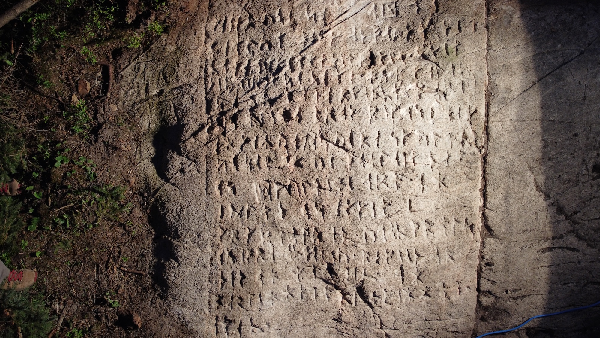
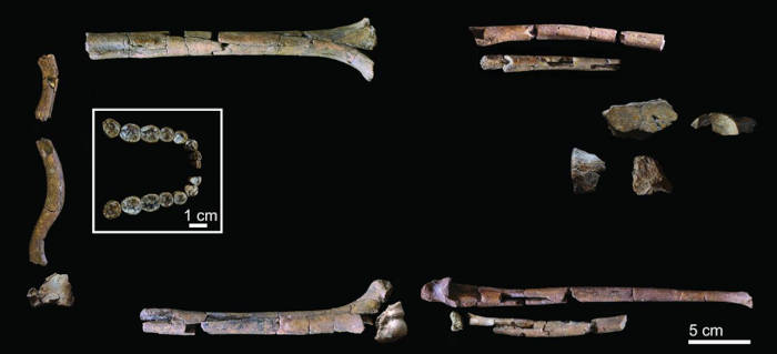
Archaeologists remain baffled by a surprising, seemingly ahistorical find located deep in the Canadian wilderness. But after years of research, analysis, and historical corroboration, an interdisciplinary team has finally made their findings available to the public. Tucked away in a forest approximately 465 miles northwest of Ottawa, a massive slab of bedrock features a hand-etched rendition of the full Lord’s Prayer. But the religious text isn’t inscribed in French or English—it’s composed of over 250 symbols from the oldest known runic alphabet.
The perplexing discovery happened completely by chance, according to the CBC. Hidden for centuries, the stone became exposed only after a tree fell near the town of Wawa, not far from Lake Superior. Closer inspection showed that someone had etched 255 runes into a roughly 4 by 5 foot section of the slab. Additionally, they took time to add a detailed illustration of a boat, an additional 16 runic signs, and 14 X markings.
“It’s certainly among the least expected discoveries of my career. It’s absolutely fascinating,” he told CBC.
It took years of planning and cooperation to analyze the mysterious stone inscription. Ryan Primrose / OCAE
Futhark runes
However, Primrose didn’t want anyone jumping to conclusions about the inscription. While it’s true that Vikings explored portions of present-day Canada thousands of years ago, he doubted they were responsible for the mystery message.
“We didn’t want to release anything publicly until we had done as much analysis as possible,” said Primrose.
He soon contacted Uppsala University emeritus professor of runology Henrik Williams, and helped the renowned expert arrange a visit to the site the following October.
“I was under a tarpaulin for three hours with a flashlight, looking at the runes and the others were sitting outside freezing,” recalled Williams.
An expert spent three hours scouring the rock for clues to decipher it. Credit: Ryan Primrose / OCAE
The group’s patience and endurance paid off. Williams eventually determined that the message was written with Futhark alphabetic runes. First developed and used by Germanic peoples between the 2nd and 8th centuries CE, Futhark eventually evolved into a simplified version adopted by Scandinavians. Both the Anglo-Saxons and Frisiacs also expanded it into their own variants, but the knowledge of how to read its original iteration died out by the High Middle Ages (around 1000-1300 CE). It wouldn’t be until 1865 that Norwegian scholar Sophus Bugge finally succeeded in deciphering the long-lost language.
People across Europe remained fascinated with runes in the interim, however. During the early 1600s, Swedish polymath (and occultist) Johannes Bureus adopted the symbols into a system that roughly corresponded to his home country’s language. This culminated in the publication of a Swedish language Lord’s Prayer written with the Futhark runes in 1611. But don’t think the Canadian oddity’s story ended there.
Researchers hope to turn the stone into a public heritage site. Credit: Ryan Primrose / OCAE
A more recent inscription
“This must have been a Swede,” Primrose said of the etcher. “Were there any Swedes at all here?”
Not during the 17th century, according to his research. That said, historical documents confirm that Hudson’s Bay Company stationed Swedish workers at trading posts across Canada beginning in the 1800s. And it just so happens that Bureus’ runic Lord’s Prayer was republished during the 19th century.
Taken altogether, Primrose and colleagues now theorize that a Hudson’s Bay Company employee—or employees—are responsible for the labor-intensive project that likely took days, if not weeks to complete.
The conservationists are now working with the local landowners on a leasehold to turn their archaeological discovery into a public heritage site that includes a protective structure to guard it against the elements.
Primrose confessed to being “a little disappointed” that the artifact is likely only a couple centuries old, but plenty of questions still surround the find. Was the site a place for religious gatherings, or the devotional effort of one person? Prior to its exposure, the bedrock also lay under multiple inches of soil. With no other artifacts found nearby, was the prayer intentionally buried?
“The mystery doesn’t fade just because it’s younger than we hoped. Why was it carved here? Why this text? There are no answers,” he said. “And mysteries always draw people in.”
A series of unusual stone formations hidden deep in the forests of northern Quebec is drawing new attention, after a local landowner spent nearly a decade documenting a discovery he believes could offer clues to Canada’s prehistoric past.
Steve Durand, founder of LeTerrain, a 400-acre wilderness sanctuary and recently designated Dark Sky Preserve in Quebec, believes he has stumbled upon a part of Canada’s ancient past that has long remained hidden on his property.
A rock musician and producer in a former life, Durand decided to step back from the music industry and return to his roots by moving back home in 2015.
“I was planning to move back to my chosen home and musical community in Montreal,” Durand recently explained in an email to The Debrief. “But I took a little detour to this property on a tip from my mom, actually, and spent two days here just intrigued by the massive private wilderness.”
It was on his second day at the property that Durand says he had what he characterizes as a “blinding epiphany” about one of its seven mountains. “I decided to leave my life in New York, buy the property, and I was living in a 140-year-old off-grid house a month later.”
When Durand initially bought the property, he never considered that there might be something of potential archaeological significance on it.
“I was motivated by the overwhelming beauty of the land,” Durand said, “and I felt connected to it. It fueled my intuition and launched me into this very illogical decision to move off-grid with no real bush experience whatsoever.”
It was only later that he discovered the massive stone formations on the property.
Following the discovery of the odd stone features, which he now refers to as “monuments,” in a series of videos on his YouTube channel, Durand reached out to locals to see if they might offer any ideas about their history and purpose.
Most area residents, he says, dismissed his discoveries, having been told they were rock piles made by Canada’s early European settlers.
Steve Durand, Founder of LeTerrain, appears alongside one of the rock formations on his property (Image Credit: LeTerrain).
“The locals had been told that it was farmers who made these structures, clearing the fields,” Durand said. However, this theory had several problems. For instance, there was no evidence of farming, nor fields that might have been used for it in the area. In some cases, Durand observed that the stone features even appeared to have been constructed into specific shapes.
“These are not found near farms or fields; they are found high up in the forested hills,” Durand told The Debrief. “They are found in clusters rather than clearing, they are constructed and built into intentional shapes, they often use extraordinarily heavy stones, and the overall accumulated tonnage of stones worked far exceeds the efforts conceivable of early settlers.”
Bringing his counter-arguments to the attention of area locals, Durand says he has now “managed to convince many of them that it makes no logical sense” that these features resulted from the work of early settlers farming on remote hilltops.
Following his discovery, Durand began researching possible interpretations of the stone features and their origins—a pursuit that he has maintained for the last decade.
Durand highlights the formations’ careful workmanship and their clustering into what he calls “megasites,” arguing that the scale and organization imply spiritual or ritual significance for the people who built them. He also suggests the structures may have been aligned with astronomical events, similar to other ancient stone traditions worldwide, and could reflect a large, long-lived culture capable of constructing monuments across a broad region.
“The territory the stoneworks define is quite specific,” Durand said. “Due to the fact that so many megasites are found all around the shores of the ancient Champlain Sea, never below the water line, and never far from the shoreline, I believe that this culture can be dated with reference to the ancient Champlain Sea around 10,000 years before present,” he says.
While archaeologists have not yet verified Durand’s interpretations, he says the discoveries at LeTerrain raise broader questions about poorly understood prehistoric activity in eastern Canada and whether undiscovered cultural landscapes may still exist in North America’s remote wilderness.
“I believe that these stone constructions are the work of a thus far unrecognized ancient culture that built representational and spiritual stone monuments on a colossal scale,” Durand told The Debrief. “Their culture terraformed landscapes from up here in West Quebec all the way down the Atlantic coast as far as Tennessee.”
Establishing Why and When
Seeking an academic perspective, The Debrief reached out to Andrew A. White, a research archaeologist with the Illinois State Archaeological Survey, for his opinions on Durand’s discoveries.
“The ‘why’ and ‘when’ questions are often tough to answer when we’re trying to interpret a pile or line of rocks made by humans,” White told The Debrief in an email.
As for determining the “why” behind Durand’s discoveries, White says that a range of factors must be considered. “People move rocks around for many different reasons—clearing fields, building walls or house foundations, making monuments, marking important locations, or creating drivelines or corrals for animals,” he said.
“Figuring out the original purpose of a pile or line of stones can be especially difficult in areas where there is more than one possible explanation,” White added. As an example, White points to known examples of how Indigenous groups in eastern North America have, at times, created rock piles for ceremonial or other purposes. White notes, however, that “later colonists created similar-looking piles and lines” as they moved stones from fields to use for homestead and farm buildings.
The “when,” White explained, can be just as tricky to identify when it comes to rock formations.
“We can’t directly date the rocks themselves, so usually we have to find something underneath the rocks that can tell us the maximum age of the surface the rocks were piled on,” White told The Debrief. “If a burned hearth underneath a rock wall dates to a thousand years ago, for example, the wall can’t be older than a thousand years. It could, in fact, have been made much more recently.”
“If I were to pile rocks on top of an archaeological site that is 10,000 years old, after a few decades, the rock pile may appear to be just as ancient as the site it is sitting on top of,” White said, “even though it is much younger.”
“The difficulty of the ‘why’ and ‘when’ questions leaves a lot of room for rock features to be misinterpreted,” White said.
Shapes and Sizes Found
In total, Durand says he has identified a variety of rock formations, ranging from stone walls to serpent-like constructions. Some, he explains, spiral up a hillside, with formations appearing at successive elevations.
“I have found so many different shapes and sizes of both the structures and the stones chosen to build them,” Durrant says. “I’ve found many shapes that recur, and I’ve put them into three main categories: mounds, structures, and infrastructure. The mounds are generally built with small stones and are oval in shape, anywhere from 6 by 10 feet to 30 by 20 feet. They all share the same proportions, differing only in size. I’ve found a cluster of 30 large mounds on one hillside.”
The structures are formed from larger stones, often 4 to 7 feet tall. “I’ve found perfect cylinders, serpentine wavy walls with massive ‘headstones,’ all with very intentional and beautifully designed curvatures,” he says.
Durand goes on to explain that “on one of the megasites, I discovered seven extraordinarily large constructions: platform mounds of smaller stones, 2 to 4 feet tall, 15 to 40 feet in diameter, topped with extremely large stones, some exceeding two tons.”
“The third category is what I call infrastructure,” he says, which Durand interprets as “roadways, pathways, retaining walls, and terracing that connect the mounds and structures within a megasite.”
A map of rock formations found on Steve Durand’s LeTerrain and the surrounding areas (Image Credit: LeTerrain).
Durand also believes the hill’s perimeter may conceal an ancient road. As sand erodes, large stones appear beneath the surface, seemingly placed intentionally along what he interprets as a road base. He says he plans to conduct a ground LiDAR scan to determine whether the feature is indeed an ancient roadway and to estimate its age, although the work would be costly.
“The infrastructure, the stone roads and pathways that you’ve witnessed surrounding Mount Bald serve no apparent logical purpose,” Durand told The Debrief. “They circumvent this one mountain and don’t lead to or from the megasite; they just exist there in three tiers in a kind of spiral of road circling this one mountain and connecting all of the greater structures.”
“Although it’s hard to tell, as 70 to 80 percent of these roads and pathways have been swallowed up by the earth over an extraordinary long period of time,” Durand said.
During a 2025 visit to Durand’s property by The Debrief, one structure, which Durand interprets as a serpent-like formation, stood out among the various stone features.
“The serpent construct is fascinating for many reasons,” Durand explained. “I have found several, and people researching through New England have found hundreds. It’s a recurring shape not only in these stone constructions but also in ancient cultures worldwide.”
“The one here on my land is about 40 feet long by 15 feet wide by four feet high and clearly undulates on both sides quite intentionally,” Durand explained during our visit.
Alleged “serpent” rock formation found on the LeTerrain property (Image Credit: Chrissy Newton/The Debrief).
“As you can see, the sides have been very specifically constructed to form this undulating wall,” Durand said. “At one end, we find, as we do with so many others in the area, a very large headstone of between 500 and 800 pounds. I feel it’s noteworthy as well that this serpentine body and head face directly into the setting sun on the winter solstice.”
Currently, the most widely accepted archaeological evidence for the earliest human presence in what is now Canada comes from sites such as Bluefish Caves in the Yukon. Dating to roughly 24,000 years ago, animal bones bearing cut marks from stone tools support the idea that humans occupied Beringia—the land bridge connecting Asia and North America—during the Last Glacial Maximum. Evidence from Bluefish Caves and other ancient North American archaeological sites upended the previously accepted “Clovis-first” model, which argued that human arrival in the Americas began no earlier than around 13,000 years ago. Many Indigenous communities across Canada also maintain oral histories that describe their deep and long-standing presence on these lands.
If confirmed, Durand’s discoveries would add to a growing number of archaeological finds in Canada that have recently attracted attention. Last year, archaeologists in northern Ontario reported the discovery of a rune-inscribed stone slab discovered in remote wilderness near Wawa, featuring 255 characters from the Nordic Futhark alphabet. The inscription was found to be a full rendering of the Lord’s Prayer, along with carvings of a boat and additional markings. Although initially thought to be ancient Viking writing, analysis suggests a much later origin, likely carved by Swedish Hudson’s Bay Company workers in the 19th century as an act of devotion.
Canada has long been home to unique archaeological discoveries. Sites such as the Peterborough Petroglyphs—known to Indigenous communities for generations—depict animals, humans, and symbolic figures, while petroforms and stone alignments across Ontario and the Prairies form large patterned arrangements of stones often linked to ceremonial, navigational, or astronomical purposes. Many of these Indigenous cultural features date back roughly 1,000 to 2,500 years and remain only partly understood, with their meanings preserved primarily through oral traditions.
Consultation, Caution, and What Comes Next
If Durand’s observations are correct, the implications could represent an important addition to Canada’s ancient history; however, the need for proper analysis of the area and its features remains essential.
Archaeologists like Andy White emphasize that stone formations alone are not enough to confirm human construction or cultural intent. Proper excavation, documentation, dating methods, and consultation with Indigenous communities are required before any conclusions can be drawn.
For his part, Durand has begun reaching out to researchers, cultural historians, anthropologists, and Indigenous representatives in an effort to move the investigation forward respectfully and transparently. However, he says he has encountered limited response and, at times, some pushback. One recent past communication was with Quebec’s Ministry of Culture and Communications, which Durand says “reached out to me shortly after my first YouTube video, saying they would be paying me a visit.”
“They sent their experts, spent the day investigating,” Durand told The Debrief. Following that initial visit, Durand said further engagement came in the form of “a couple of years of Zoom calls with their team as I pushed for proper investigation, validation, and protection of the site.”
Ultimately, Durand says representatives with Quebec’s Ministry of Culture told him there was “nothing of archeological interest” to the sites.
“Which, to me, translates into ‘these are not Algonquin’,” Durand told The Debrief. Nonetheless, officials with Quebec’s Ministry of Culture had reportedly advised Durand not to disturb the sites, “just in case.”
The Debrief also reached out to Quebec’s Ministry of Culture regarding Durand’s claims, but received no response to our inquiries.
A First Nations Elder’s Perspective
Peter Ittinuar Freuchen, an Inuk elder and former Canadian Member of Parliament who was instrumental in the formation of Nunavut—the largest and northernmost territory of Canada—also commented on the formations during a YouTube interview on Durand’s Le Terrain channel (seen below), where he notes that traditionally “the Algonquin have been shown these rock structures, and they said these these are not us; these were not made by us.”
“Apparently, government officials have come and looked at these structures and said they were made by the farmers in the area,” Freuchen said, echoing Durand’s interpretations by adding that “there is no reason for the farmers of the area to make these structures whatsoever. They were too busy trying to feed their families.”
“These structures are symbolic,” Freuchen says in the video, suggesting that there may have been “a spiritual reason to be there.”
“If they were not made by the Algonquin … then the conclusion can be made that they were made by people before the Algonquin,” Freuchen says.
Freuchen also notes in the interview that archaeologists have long debated who first arrived on what is now Canadian soil.
“The Inuit and anthropology agree,” Freuchen says in the video, adding “that there were people before we Inuit—we called them the Tuniit—I thinkanthropologists called them the pre-Dorset culture. And there was an overlap when the Inuit came into the Arctic areas, the Tuniit were there. They were a different people, physically—apparently bigger, according to oral history—apparently bigger, stronger physically, but very, very timid, employing very much the same technology that the Inuit have, but not as advanced.”
According to oral histories, the Tuniit gradually died out over time, although anthropological views on the persistence of what is commonly called the Dorset culture into recent centuries differ from accounts in Inuit oral history.
At the interview’s conclusion, Freuchen says that his observations of the stone structures on Durand’s property “astounded” him, adding that they could point to echoes of Canada’s pre-Algonquin culture.
“If the Algonquin say these are not ours, they were not obviously made by farmers on a whim, or for symbolic or spiritual reasons, the only real conclusion I can come to here as a layman is that these were made pre-Alonquin, and there were people before them here,” Freuchen says.
Lingering Questions
Durand says that in the future, ground-penetrating radar scans will be conducted to better understand whether anything exists beneath the surface of the hill that could provide additional context for the stone structures, as well as whether their placement could reveal clues to their design.
For archaeologists like Andy White, such information could offer crucial evidence to help establish when these features were assembled and, ultimately, what the builders’ purpose might have been.
“To get accurate interpretations of these kinds of stone features, you first need evidence that establishes when they were built,” White told The Debrief. “And then you need to work carefully to develop ideas about why they were built.”
“The more independent lines of evidence you can utilize, the better,” White added.
“That’s how you build a convincing case.”
Chrissy Newton is a PR professional and the founder of VOCAB Communications. She currently appears on The Discovery Channel and Max and hosts the Rebelliously Curious podcast, which can be found on YouTube and on all audio podcast streaming platforms. Follow her on X: @ChrissyNewton, Instagram: @BeingChrissyNewton, and chrissynewton.com. To contact Chrissy with a story, please email chrissy @ thedebrief.org.
Waarom De Oudse Chinese Piramides In De Schaduw Van Mysterie Zitten
Waarom De Oude Chinese Piramides In De Schaduw Van Mysterie Zitten
China is een land vol mysteries. De geschiedenis van de Oude Chinese Piramides, die effectief door de Chinese overheid verborgen worden gehouden, blijven een van de grootste geheimen die nog moeten worden ontrafeld. Deze intrigerende monumenten roepen vragen op over de oude beschavingen die ooit in dit immense land bloeiden en over de motivaties achter het verbergen ervan. In dit artikel duiken we dieper in de mysterieuze piramides in Noordwest-China, de redenen waarom ze nog steeds bedekt zijn met geheimen en wat de recente ontdekkingen ons kunnen vertellen over hun ware aard.
De Mysterieuze Piramides van Noordwest-China
China blijft de wereld boeien met zijn rijke geschiedenis, indrukwekkende economische groei en complexe politieke structuren. Naast deze bekende aspecten, herbergt het land ook vele verborgen schatten uit het verleden, waaronder de mysterieuze piramides in Noordwest-China. Deze oude monumenten, die dateren uit verschillende historische periodes, blijven voor velen een fascinerend en onbegrepen fenomeen. Wat deze piramides zo bijzonder maakt, is niet alleen hun leeftijd, maar ook het feit dat ze lang verborgen zijn gebleven voor het publiek en zelfs voor de meeste onderzoekers. Het Chinese gouvernement heeft deze bouwwerken bewust afgesloten van de publieke kennis om diverse redenen, waaronder het beschermen van de sites of mogelijk vanwege politieke of culturele overwegingen.
De piramides in Noordwest-China liggen vaak op afgelegen locaties, weg van de grote steden en toeristische trekpleisters, wat de ontdekking en studie ervan bemoeilijkt. Pas in de 21e eeuw, met de komst van geavanceerde technologieën zoals satellietbeelden, drones en 3D-scanning, werd het mogelijk om deze geheime sites te identificeren en in kaart te brengen. Wetenschappers ontdekten dat deze piramides niet alleen unieke architectonische structuren zijn, maar dat ze ook mogelijk een belangrijke rol spelen in de oude cultuur en rituelen van de regio. Sommige archeologen geloven dat ze verband houden met de oude stammen die in het gebied leefden, terwijl anderen speculeren dat ze mogelijk verbonden zijn met de Zijderoute en handelsnetwerken uit de oudheid.
De exacte leeftijd en functie van de piramides blijven echter onderwerp van debat. Sommige dateringen wijzen op een leeftijd van meer dan 2.000 jaar, terwijl andere theorieën suggereren dat ze nog ouder kunnen zijn. Onderzoek naar de gebruikte bouwmaterialen en de artefacten die bij de piramides zijn gevonden, wijst op een complexe samenleving met geavanceerde bouwtechnieken en uitgebreide handelsnetwerken. Het ontbreken van uitgebreide schriftelijke bronnen maakt het echter moeilijk om definitieve conclusies te trekken.
De recentelijke ontdekking van deze piramides heeft niet alleen het wetenschappelijke wereldje verrast, maar ook het publieke bewustzijn over de rijke en gevarieerde geschiedenis van China verhoogd. Er wordt momenteel gewerkt aan het behoud en de studie van deze archeologische schatten, met het oog op toekomstig onderzoek en mogelijke openstelling voor toeristen onder strikte voorwaarden om de sites te beschermen. Het blijft een fascinerend mysterie dat de nieuwsgierigheid van historici en avonturiers uitlokt, en dat zeker nog vele jaren onderwerp van studie en discussie zal zijn. Met de voortdurende technologische vooruitgang zal hopelijk meer inzicht worden verkregen in de ware geschiedenis en betekenis van deze oude piramides.
Een Glimp Van Het Chinese Piramide-landschap
De piramides die nabij de oude stad Xi’an in de provincie Shaanxi liggen, vormen een fascinerend en mysterieus onderdeel van China’s rijke historisch erfgoed. Deze piramides bevinden zich in een gebied dat bekend staat om zijn vele oude begraafplaatsen en archeologische vindplaatsen, en worden vaak beschouwd als de rustplaatsen van oude koninklijke dynastieën en prominente historische figuren. In tegenstelling tot de bekende piramides van Egypte, die uit monumentale structuren bestaan die bedoeld zijn om hun farao’s voor altijd te eren, lijken de Chinese piramides meer op natuurlijke heuvels of glooiende begraafplaatsen die in het landschap zijn geïntegreerd.
De Chinese piramides zijn meestal bedekt met gras, struiken en bomen, waardoor ze op het eerste gezicht niet meteen opvallen, maar eerder op natuurlijke heuvels die deel uitmaken van het landschap. Dit natuurlijke uiterlijk heeft geleid tot veel speculaties en mysteries over hun ware aard en gebruik. Sommige archeologen geloven dat deze structuren oorspronkelijk bedoeld waren als grafmonumenten voor belangrijke leiders en aristocraten, terwijl anderen suggereren dat ze mogelijk ook ritualistische of ceremoniële functies hadden.
Volgens westerse experts worden er momenteel meer dan 40 piramides geschat in China, maar de Chinese overheid beweert dat er meer dan 400 bestaan. Deze grote discrepantie roept vragen op over de werkelijke omvang van dit piramide-landschap en over de manier waarop deze structuren in de loop der eeuwen zijn geïnterpreteerd en gerestaureerd. Het kan zijn dat veel van deze piramides nog niet volledig zijn ontdekt of dat ze door de tijd heen zijn bedekt met natuurlijke begroeiing, waardoor ze moeilijk te identificeren zijn.
Het onderzoek naar deze piramides is nog in volle gang, en veel archeologen en historici zijn gefascineerd door hun mysterie. Sommige onderzoekers vermoeden dat ze dateren uit de Qin- en Han-dynastieën (ca. 3e eeuw v.Chr. tot 3e eeuw n.Chr.), en dat ze een belangrijke rol speelden in de begrafenisrituelen en het religieuze leven van die tijd. Daarnaast blijven vragen bestaan over de technieken die werden gebruikt voor de bouw en de functies die deze structuren hadden binnen de oude Chinese samenleving.
De Chinese piramides vormen niet alleen een fascinerend stukje geschiedenis, maar ook een bron van discussie en onderzoek voor archeologen en historici wereldwijd. Ze bieden een unieke inkijk in de oude Chinese cultuur en begrafenispraktijken, en blijven een mysterie dat nog voor veel nieuwe ontdekkingen en interpretaties vatbaar is. Door hun natuurlijke uiterlijk en hun locatie nabij Xi’an, blijven ze een intrigerend voorbeeld van de oude Chinese architectuur en de manier waarop deze samenleving haar leiders vereerde en herdacht. Kortom, de Chinese piramides vormen een onmisbaar onderdeel van het wereldwijde erfgoed en blijven een boeiend onderwerp voor verdere studie en verkenning.
De Enigmatische Witte Piramide en Overheidsgeheimen
Een van de meest fascinerende en mysterieuze structuren uit de geschiedenis is de zogenaamde Witte Piramide. Deze indrukwekkende bouwwerk staat bekend om zijn onvoorstelbare omvang en ondoorgrondelijke geheimen. Volgens diverse geruchten zou de piramide wel twintig keer groter zijn dan de beroemde Grote Piramide van Giza in Egypte, en zou de hoogte meer dan 300 meter bedragen. Deze indrukwekkende afmetingen maken het een van de grootste en meest intrigerende archeologische mysteries ter wereld. Echter, de locatie van de piramide en de exacte details blijven voor het grootste deel onontdekt, omdat de Chinese overheid strenge restricties heeft opgelegd voor onderzoek en toegang.
Omdat onderzoekers en archeologen geen officiële toegang krijgen tot de site, zijn er talloze complottheorieën en speculaties ontstaan over de ware aard en doelstellingen van de piramide. Sommigen geloven dat de Witte Piramide een krachtig energiecentrum is, mogelijk gerelateerd aan oude beschavingen die veel verder gingen dan de huidige kennis toelaat. Anderen denken dat het een soort opslagplaats voor waardevolle artefacten of zelfs een toegang tot ondergrondse tunnels naar geheime ondergrondse bases zou kunnen zijn. Er zijn ook theorieën dat de piramide onderdeel is van een grootschalig overheidsgeheim, mogelijk gerelateerd aan militaire of bovennatuurlijke doeleinden.
Officieel geven Chinese functionarissen aan dat de restricties te maken hebben met traditie en het risico op schade aan de monumenten of de rust van de overledenen. Ze benadrukken dat het beschermen en respecteren van de begrafenissen prioriteit heeft. Volgens de officiële verklaring zou het openstellen van de site aan toeristen en wetenschappers te riskant zijn, niet alleen voor het behoud van de structuren, maar ook uit respect voor de begrafenisrituelen die eeuwenoud zijn. Daarnaast wordt gesuggereerd dat de piramide mogelijk een belangrijke culturele en religieuze betekenis heeft binnen de Chinese geschiedenis, en dat het openen ervan zonder de juiste procedures schadelijk kan zijn.
De Witte Piramide van Xian
Desalniettemin blijven de geruchten en theorieën bestaan, mede gevoed door het gebrek aan officiële informatie en de geheimzinnigheid rond de site. Sommige onderzoekers vermoeden dat de Chinese overheid bewust informatie achterhoudt om politieke of strategische redenen, gezien de potentiele waarde en het mysterie dat de piramide omringt. Er zijn zelfs geruchten dat de piramide verbonden zou kunnen zijn met oude beschavingen die veel verder gingen dan de bekende Chinese dynastieën.
In samenvatting blijft de Witte Piramide een symbool van mysterie en overheidsgeheimen. Hoewel de officiële standpunten wijzen op respect voor traditie en archeologisch behoud, blijven de vele onbeantwoorde vragen en de theorieën over verborgen kennis en macht de nieuwsgierigheid van ontdekkingsreizigers en onderzoekers voeden. De ware aard en doelstellingen van de piramide blijven een intrigerend raadsel dat mogelijk voor altijd verborgen zal blijven, tenzij de geheimen op een dag ontsluierd worden.
Beperkte Opgravingen en Verborgen Monumenten
Meer dan een eeuw na de eerste ontdekking van deze mysterieuze piramides zijn er slechts twee die volledig zijn uitgegraven en uitgebreid bestudeerd door archeologen. Deze beperkte onderzoeksinspanning betekent dat veel van de structuur en de inhoud van de andere piramides nog altijd grotendeels onontdekt en onbegrijpelijk zijn. Sommige van de piramides zijn omgevormd tot nationale parken of toeristische attracties, waardoor het publiek de monumenten kan bewonderen, maar verdere archeologische opgravingen blijven vaak achterwege. De redenen hiervoor zijn onder meer politieke en culturele overwegingen, die het belang benadrukken van het behoud van het erfgoed zonder te verstoren.
Veel van de piramideheuvels lijken bewust aangeplant met bomen en struiken, wat het moeilijk maakt om de volledige omvang en interne structuur onder het oppervlak te bepalen. Deze begroeiing kan zowel een natuurlijke als een door de mens gemaakte ingreep zijn, bedoeld om de geheimen van de piramides te beschermen of te maskeren. Het feit dat de meeste van deze monumenten niet volledig zijn blootgelegd, roept vragen op over de ware aard en functie ervan. Het is mogelijk dat er onder de aarde nog oude schatten, hiërogliefen of technologieën verborgen liggen die momenteel nog niet toegankelijk zijn.
De Chinese autoriteiten lijken bewust de geheimen onder de grond te willen bewaren, mogelijk uit respect voor de overledenen of uit angst voor de gevolgen van het blootleggen van oude kennis. Het onderdrukken of beperken van archeologisch onderzoek kan ook voortkomen uit politieke overwegingen, bijvoorbeeld om nationale trots te beschermen of om het verhaal over de geschiedenis van de regio niet te verstoren. Daarnaast kan het beperken van opgravingen ook te maken hebben met het beschermen van het toeristische potentieel, omdat grootschalige archeologische activiteiten mogelijk de stabiliteit en het imago van de regio kunnen beïnvloeden.
Kortom, de piramides in China blijven voor het grootste deel een mysterie. De beperkte opgravingen en de bewuste bescherming van de ondergrondse monumenten zorgen ervoor dat veel vragen onbeantwoord blijven en dat de ware geschiedenis van deze oude bouwwerken nog altijd grotendeels verborgen is onder een deken van geheimhouding en natuurlijke begroeiing. Toekomstig onderzoek zou kunnen leiden tot nieuwe ontdekkingen die ons meer inzicht geven in de cultuur en technologie van de oude beschavingen die deze piramides hebben gebouwd, maar vooralsnog blijven veel van de monumenten een fascinerend mysterie.
De Mysterieuze Uitlijning Van Chinese Piramides
Hoewel de precieze locaties van alle Chinese piramides nog steeds onbekend zijn, hebben moderne technologieën zoals satellietbeelden en GPS-analyses enkele fascinerende patronen blootgelegd die ons inzicht geven in de oude Chinese beschaving. Een opvallend fenomeen is dat de piramides in twee duidelijke uitlijningen staan: één groep ligt precies uitgelijnd met de kardinale richtingen (noord, oost, zuid, west), terwijl een andere groep een afwijking vertoont van ongeveer 14 graden ten opzichte van het ware Noorden. Deze afwijkingen laten zien dat de oude bouwers mogelijk beschikten over geavanceerde kennis van sterren en hemellichamen. Het wordt aangenomen dat de piramides in de eerste groep mogelijk gericht waren op belangrijke sterren of hemellichamen, zoals de Noordster (Polaris), die een centrale rol speelde in de Chinese astronomie en kalenderkunde.
De afwijking van 14 graden in de andere groep zou kunnen wijzen op een complexe astronomische observatie- en uitlijningsmethode, waarbij de oude Chinese astronomen sterrenkijkers gebruikten om de piramides nauwkeurig te positioneren. Dit zou betekenen dat ze niet alleen eenvoudige bouwtechnieken hadden, maar ook een diepgaand begrip van de bewegingen van hemellichamen en de wisselwerking tussen sterren en aarde. Het feit dat deze uitlijningen mogelijk al duizenden jaren geleden plaatsvonden, wijst op een indrukwekkend wetenschappelijk inzicht dat verder gaat dan tot nu toe werd aangenomen over de oude Chinese beschavingen. De exacte reden achter deze verschillende uitlijningen blijft een mysterie, maar het bevestigt dat de oude Chinese ingenieurs en astronomen beschikten over een hoge mate van kennis en precisie. Het ontdekken van deze patronen opent nieuwe perspectieven voor het begrijpen van de oude Chinese cultuur en haar kennis van het heelal. Het blijft een boeiend onderwerp dat uitnodigt tot verder onderzoek en discussie onder archeologen en astronomen.
Waarom Zijn De Piramides Zo Geheimzinnig?
De piramides in China, vooral die in de regio van de Wei River-vallei en de bijbehorende begraafplaatsen, vormen al sinds jaren een fascinerend mysterie voor archeologen, historici en liefhebbers van het onbekende. Hun geheimzinnigheid wordt door velen gevoed door de beperkte toegang die de Chinese overheid verleent en door de onduidelijkheid over de ware aard en oorsprong van deze monumenten. Maar waarom blijven deze piramides zo lang gesloten en waarom worden ze zo zorgvuldig beschermd? Er zijn verschillende theorieën en speculaties die proberen een antwoord te geven op deze vraag.
Een belangrijke reden die vaak genoemd wordt, is de angst voor het blootleggen van oude kennis en technologieën die mogelijk de hedendaagse geschiedenis kunnen herzien. Sommige onderzoekers stellen dat de piramides niet zomaar graven zijn van koningen of heersers, maar dat ze mogelijk geavanceerde technologische of wetenschappelijke kennis bevatten die verloren is gegaan in de loop der eeuwen. Het openbaar maken hiervan zou kunnen leiden tot grote culturele en wetenschappelijke schokken. De Chinese overheid zou daarom aarzelen om deze kennis vrij te geven, uit angst voor maatschappelijke onrust of het ondermijnen van het nationale verhaal.
Daarnaast speelt het beschermen van de rust en de integriteit van de overledenen een grote rol. In de Chinese cultuur wordt het koesteren van de rust van de voorouders en het respect voor hun grafplaatsen als uiterst belangrijk beschouwd. Het openen van de piramides voor toeristen of onderzoekers zou de rust verstoren en mogelijk leiden tot beschadiging of vernietiging van de monumenten. Bovendien zijn sommige piramides mogelijk nog niet volledig onderzocht of veilig bevonden voor publiek, vanwege de complexiteit van de ondergrondse structuren en de risico’s op instortingen.
Een andere intrigerende theorie suggereert dat de piramides deel uitmaken van een groter, nog onbekend netwerk van oude monumenten, die mogelijk buitenaardse invloeden of technologieën bevatten. Sommige onderzoekers geloven dat deze structuren niet alleen voor begrafenisrituelen dienden, maar ook als knooppunten in een oud wereldwijde communicatiestructuur of als energiestations. Deze theorieën worden vaak aangevuld met speculaties over buitenaardse betrokkenheid, waarbij de piramides worden gezien als bewijzen van een oude, geavanceerde beschaving die contact had met buitenaardse wezens.
Tot slot kan de geheime aard van de piramides ook te maken hebben met politieke en nationale belangen. Het beschermen van deze monumenten versterkt het nationale erfgoed en het gevoel van trots onder de Chinese bevolking. Door de piramides gesloten te houden, wordt ook een aura van mysterie en prestige gecreëerd, wat het internationale aanzien van China op het gebied van archeologie en geschiedenis kan vergroten.
Kortom, de geheimzinnigheid rond de Chinese piramides wordt door een combinatie van culturele, religieuze, technologische, en politieke factoren gevoed. Het blijft een intrigerend mysterie dat nog vele jaren de aandacht zal vasthouden van onderzoekers en nieuwsgierigen wereldwijd. Het is wellicht slechts een kwestie van tijd voordat nieuwe ontdekkingen meer licht zullen werpen op deze oude, mysterieuze monumenten.
Wat Betekent Dit Voor De Toekomst?
Met de voortdurende vooruitgang in technologie en archeologische methoden, is het waarschijnlijk dat we in de komende jaren meer zullen ontdekken over de Chinese piramides. Satellietbeelden, LIDAR-technologie en ondergrondse scans kunnen helpen om de geheimen onder het oppervlak te onthullen zonder de monumenten te beschadigen. Het gebruik van satellietbeelden maakt het mogelijk om grote gebieden vanuit de ruimte te onderzoeken, waardoor we patronen en structuren kunnen identificeren die met het blote oog moeilijk zichtbaar zijn. LIDAR-technologie, die laserstralen gebruikt om de topografie van het terrein te meten, kan onder vegetatiedek en aardlagen kijken, waardoor verborgen piramides en ondergrondse gangen worden blootgelegd. Ondergrondse scans en geavanceerde geofysische technieken kunnen inzicht geven in de structuur en opbouw van deze bouwwerken zonder dat ze fysiek moeten worden geopend of beschadigd.
Daarnaast is het waarschijnlijk dat de Chinese overheid in de toekomst meer openheid zal tonen over deze mysterieuze bouwwerken. Tot nu toe zijn veel van de piramides bedekt gebleven onder een laag geschiedenis en geheimzinnigheid, deels door het ontbreken van gedetailleerde documentatie en deels door politieke overwegingen. Echter, met toenemende internationale belangstelling en wetenschappelijke samenwerking, kunnen we een meer open en transparante benadering verwachten. Internationale teams van archeologen, historici en technologische specialisten zouden worden uitgenodigd om samen te werken aan opgravingen, onderzoek en publicaties. Dit zou niet alleen de kennis over de piramides vergroten, maar ook de interculturele dialoog en samenwerking stimuleren.
Het onthullen van de ware aard van deze piramides kan onze kennis van de oude Chinese beschaving aanzienlijk verrijken. Het zou kunnen leiden tot nieuwe inzichten over de sociale structuur, religieuze praktijken en technologische vaardigheden van de oude bewoners. Bovendien kunnen de ontdekkingen de geschiedenis van de mensheid in bredere zin beïnvloeden, door te laten zien dat oude beschavingen wereldwijd hun eigen indrukwekkende bouwwerken en mythologieën ontwikkelden. Deze nieuwe kennis zou ook kunnen bijdragen aan het toerisme en de cultuurbeleving in China, waardoor meer mensen de rijke geschiedenis en erfgoed van het land kunnen waarderen.
Kortom, de toekomst van de Chinese piramides ziet er veelbelovend uit. Dankzij technologische innovaties en internationale samenwerking kunnen we binnenkort meer ontdekken over deze mysterieuze structuren. Deze ontdekkingen zullen niet alleen onze kennis verdiepen, maar ook onze waardering voor de oude beschavingen en hun prestaties vergroten. Het is een spannend tijdperk waarin wetenschap, technologie en cultuur samenkomen om de geheimen van het verleden te onthullen, en dat zal ongetwijfeld grote invloed hebben op ons begrip van geschiedenis en menselijke innovatie.
Conclusie
De Chinese piramides blijven een van de meest intrigerende mysteries van de oude wereld. Hun verborgen aard, de enorme omvang en de mogelijke astronomische uitlijningen wijzen op een geavanceerde beschaving die veel meer wist dan wij nu kunnen begrijpen. De geheimen onder de grond en de restricties van de Chinese overheid voeden de speculatie en het mysterie rondom deze monumenten. Terwijl technologie ons dichterbij brengt om deze mysteries te ontrafelen, blijft de vraag hangen: wat weten de oude Chinese piramides werkelijk, en waarom worden ze zo zorgvuldig verborgen gehouden? Het antwoord op deze vragen kan onze kijk op de menselijke geschiedenis voorgoed veranderen.
An extremely advanced civilization that flourished during the Ice Age was wiped off the face of the planet about 13,000 years ago by a massive collision with a comet, and the ancients have left us a warning for future events, researchers claim.
As the best-selling author and researcher Graham Hancock explains in his book “Magicians of the Gods: The Forgotten Wisdom of Earth’s Lost Civilization”, at the end of the last Ice Age, 12,800 years ago, a giant comet shattered into numerous pieces. Some of them collided with Earth, causing a global cataclysm of unprecedented proportions since the extinction of the dinosaurs. At least eight of the debris hit the North American ice cap, while other debris hit the northern European ice cap.
The one-and-a-half-kilometer-wide collisions with the comet’s debris, approaching more than 150,000 kilometers per hour, generated huge amounts of heat that instantly liquefied millions of square kilometers of ice, destabilizing the Earth’s crust and causing a global flood remembered in myths around the world.
For years, the claims of writer Graham Hancock were ignored by scientists, who argued that it is impossible for a developed civilization to have inhabited the Earth tens of thousands of years ago.
Hancock’s Theory and the evidence of a Comet Impact in the ancient monument of Gobekli Tepe
Aerial view of Gobekli Tepe, main excavation area. Credit: UNESCO-Places of Worship
Considered by many to be a dreamer and by many others to be a deluded author, much of his work was ignored by “experts” who refused to accept anything beyond what they firmly believed in – a timeline of Earth’s history, shattered from those same specialists who cannot fully explain the many historical enigmas that cast a shadow over our origins.
But suddenly, when experts from the University of Edinburgh’s School of Engineering published an interesting scientific paper, Hancock’s words, long ignored, suddenly became less absurd to the scientific community.
According to scientists, the intricate stone carvings found on Gobekli Tepe – the oldest temple on Earth – are evidence that a comet collided with Earth about 11,000 BC. This collision led to cataclysmic events that wiped out civilization on Earth.
Research has determined that the oldest layer of Gobekli Tepe dates around 9600 BC. Therefore, it is 6,500 years older than Stonehenge and 7,000 years older than the Pyramids.
As Hancock explained, there is evidence around the world that speaks to such a massive collision. This flaming cosmic rock has crashed into our planet, hitting the earth’s crust with the force of several atomic bombs exploding simultaneously. This cataclysmic event wiped out several large animal species and nearly wiped out humanity.
Interestingly, this is exactly what Dr. Martin Suetman from Edinburgh discovered when he examined some of the stone pillars of Gobekli Tepe in present-day Turkey.
“One of the pillars of Gbekli Tepe seems to have served as a monument to this devastating event – probably the worst day in history since the end of the Ice Age.”
The intricate carvings found on Gobekli Tepe depict a man without a head – a graphic symbol of human bloodshed. The so-called Gobekli Tepe’s “Vulture Stone” illustrates interesting symbols that tell an incredible story.
Experts found images of animals carved on the Vulture Stone and found that the animals were in fact astronomical symbols. Using sophisticated computer software, the scientists linked the symbols to motifs in the sky and found that they were related to an event that occurred around 10,950 BC.
As scientists explain, the symbols carved on the stone pillars have to do with a cosmic event believed to have been the collapse of a massive comet from the inner solar system, just during the period known as the Younger Dryas. This period is considered a turning point for humanity, as it coincides with the emergence of agriculture and the first Neolithic civilizations.
But how is it at all possible that the builders of Gobekli Tepe – more than ten thousand years ago – carved intricate astronomical symbols on stone pillars? According to experts at the time, humans were “savages”, hunter-gatherers, no more developed than the caveman, without any knowledge of engineering or mathematics.
Clearly, something in the story has to be quite the opposite. Hancock notes that the stone slabs of Gobekli Tepe not only describe an ancient cosmic collision but also predict another one that is yet to come.
Hancock claims that the ancient collision, recorded on the Vulture Stone of Gobekli Tepe, was in fact with massive remnants of the Taurid meteor shower – a belt containing millions of cosmic rocks. Astronomers believe that inside this belt is a massive planetoid, a superheated rock – something like a massive space hand grenade.
Many of the remains hidden in the belt could be three to four times larger than the one that collided with Earth 65 million years ago and caused the extinction of the dinosaurs. Hancock also notes that we are expected to cross the Taurid meteor shower in 10 years, around 2030.
Scientists Unearth Over 200 Fossilized Eggs Found in a Single Block in China, and What They Found Inside Is Rare
More than 200 fossilized eggs belonging to the flying reptile Hamipterus tianshanensis have been unearthed in northwestern China. The discovery includes at least 16 partial embryos, several preserved in three dimensions.
The find, reported in Science, marks one of the largest collections of pterosaureggs ever documented. According to the research team led by Xiaolin Wangof the Chinese Academy of Sciences, the eggs date back roughly 120 million years to the early Cretaceous period.
Until now, pterosaur reproduction had remained largely mysterious. Only a handful of eggs had previously been identified worldwide, five from the same Chinese site and two from Argentina, one of which contained a flattened but well-preserved embryo. This new concentration changes the scale of available evidence and allows researchers to move beyond isolated specimens.
A Rock Containing 215 Eggs
The eggs were recovered from a sandstone block measuring about three meters square. According to the study published in Science, at least 215 eggs were identified, all attributed to Hamipterus tianshanensis, a species that lived in what is now Xinjiang, China.
“The specimens can be attributed to Hamipterus tianshanensis, the sole species in this bonebed. The most important section is a sandstone block (3.28 m²) that yielded 215 eggs, but up to 300 may be present, because several more appear to be buried under the exposed ones,” said Xiaolin Wang.
Earlier discoveries at the site had yielded only five eggs, as previously reported in Science News. The new excavation dramatically expands the sample size. Researchers confirmed that at least 16 of the eggs contain partial embryos, some of them preserved in three dimensions rather than flattened.
Such preservation is unusual. Pterosaur eggs had soft, thin shells, more similar to those of modern lizards than to the rigid shells of dinosaurs or birds. That softness often led to deformation during fossilization, which helps explain why intact embryos are so rare.
Over 200 fossilized eggs of Hamipterus tianshanensis embedded in sandstone. Credit: Xiaolin Wang
Preserved by Flood and Rapid Burial
The eggs were not found in their original nesting positions. According to Alexander Kellner of the Museu Nacional/Universidade Federal do Rio de Janeiro, co-author of the study, they appear to have been jumbled and deformed after being transported by floodwaters during an intense storm.
Sediment carried by the water likely buried the eggs quickly. Kellner explained that rapid burial was necessary for preservation because the soft-shelled ones would otherwise have decomposed. The sandstone block itself suggests a high energy event capable of moving and concentrating the clutch.
Embryo preserved part of a wing and a complete lower jaw, shown in ventral and close-up views. Credit: Xiaolin Wang
Embryos Suggest Walking Before Flight
Researchers used computerized tomography to scan the find and examine their contents without damaging them. Two of the best-preserved embryos provided key anatomical details.
A wing structure known as the deltopectoral crest, critical for anchoring flight muscles, was not fully developed, even in an embryo interpreted as nearly at term. In contrast, the femur was well developed. Researchers behind the study sayid that:
“computed tomography scanning, osteohistology, and micropreparation reveal that some bones lack extensive ossification in potentially late-term embryos, suggesting that hatchlings might have been flightless and less precocious than previously assumed.”
That interpretation has drawn caution. D. Charles Deeming of the University of Lincoln, who was not involved in the research, noted in a column published in the same issue that determining whether an embryo was truly near term is difficult. He warned of “a real danger of overinterpretation.”
Still, the unusually large sample offers new opportunities. With hundreds of eggs available for measurement, researchers can now examine variation in size and shape.
Visual reconstruction of a nesting group of Hamipterus tianshanensis. Credit: Xinhua
Beautiful Petroglyphs Discovered in Venezuela Give Hints of Ancient Culture
Beautiful Petroglyphs Discovered in Venezuela Give Hints of Ancient Culture
A newly recorded set of rock carvings in Venezuela’s Monagas state is being described as potentially among the country’s oldest known examples of rock art, with an estimated age ranging from 4,000 to 8,000 years. The petroglyph panel - marked by spirals, concentric circles and human-like forms - was located in a highland area of the Quebrada Seca community in Cedeño, and local officials are now pushing for formal certification and protection, reports Heritage Daily. If the early age range holds up under scientific study, the discovery could reshape how researchers think about early symbolic traditions in eastern Venezuela.
According to reports by Ultimas Noticias, the petroglyph was found in the upper zone of Quebrada Seca, around 3.5 km (2.2 miles) from the town of San Félix, at roughly 650 meters (2125 feet) above sea level. The site was announced by Cedeño’s mayor, Daniel Monteverde, alongside a commission linked to Venezuela’s National Land Institute, after what was described as a period of local research and location work. Initial descriptions highlight circular and spiral engravings carved with notable precision on a naturally formed rock surface.
Authorities examining the rock where the petroglyphs have been discovered.
The municipality is often presented as a rock-art hotspot within the state, and Heritage Daily notes that Cedeño is widely regarded locally as the “petroglyph capital” of Monagas because of the broader indigenous legacy in the area. The engravings themselves - geometric and anthropomorphic - are being interpreted as potentially tied to cosmology, water cycles, solar symbolism, and ancestral spirits, themes that recur across many ancient rock art traditions. For readers wanting broader background on what petroglyphs are (and how they differ from paintings), Ancient Origins has a hub of articles on its Petroglyphs topic page.
Rock art panel in the Upuigma-tepui table-top mountain area of Canaima National Park, Venezuela.
Courtesy of José Miguel Pérez-Gómez/Proyecto Arqueológico Canaima/Axios
Why “8,000 years” is a Big Claim
The reported age, between 4,000 to 8,000 years, appears to be an estimate based on relative and stylistic assessment rather than a published laboratory date, and that distinction matters. Petroglyphs are notoriously difficult to date directly, so researchers often rely on a mix of contextual archaeology, superimposition sequences, erosion/patina analysis, and comparisons with dated materials nearby. Heritage Daily also describes the carving style as a “linear low-relief” approach, typically produced through abrasion and pecking with stone tools, sometimes using sand and water as an abrasive.
Monagas is not the only Venezuelan region producing major rock-art headlines, and comparison cases can help frame what is plausible. In 2024, archaeologists working in Canaima National Park reported dozens of rock art sites featuring pictograms and petroglyphs, with some discussion around the possibility of an as-yet poorly understood cultural tradition in that landscape, explains Live Science. While that research focuses on a different region of the country, it underlines how much remains undocumented and how quickly a new find can expand the map.
Protection, Tourism—and the risk of losing the evidence
In the short term, the bigger story may be what happens next: documentation, dating, and whether the site can be safeguarded before weathering or people do damage. That urgency is familiar to anyone who follows petroglyph finds globally, where the moment a location becomes widely known can also be the moment it becomes vulnerable.
Local authorities say their immediate goal is to geolocate and safeguard the site, explicitly citing vandalism prevention, while also developing an “archaeological route” tied to sustainable tourism. The balance of public access versus conservation is delicate, because even light touching, chalking, or repeated foot traffic can accelerate deterioration. Monteverde has also indicated plans to meet with cultural authorities, including Venezuela’s national cultural heritage bodies, to formalize certification steps reports Últimas Noticias.
The wider Orinoco basin offers a reminder of both the scale of Venezuela’s rock art and the long timelines involved. A major 2024 study of monumental engravings along the Orinoco, discussed by Smithsonian Magazine, documented numerous large figures—snakes, animals, and human forms—and argued that visibility and placement may have mattered as much as the images themselves. Even though those Orinoco carvings are thought to be around 2,000 years old, their prominence shows how rock art could function as communication in a river landscape.
Top image: Petroglyphs engraved on boulder in Venezuela’s Monagas state.
Eeuwenoude mysteries die onderzoekers nog steeds niet kunnen verklaren De oudheid spreekt al eeuwenlang tot de verbeelding van het publiek. Van verloren begraafplaatsen tot verzonken steden, er zijn nog steeds veel dingen die een mysterie blijven voor historici en archeologen. En hoewel wetenschap en technologie grote vooruitgang hebben geboekt, maken deze onopgeloste mysteries onze wereld ontzettend fascinerend.
Van mysterieuze geogliefen in de Nazca-woestijn tot honderden perfect ronde bollen in de jungle van Costa Rica, klik verder om een paar van de meest hardnekkige mysteries van de oude wereld te ontdekken.
Antikythera-mechanisme Een 2000 jaar oude mechanisme van Antikythera, dat ook wel de ‘eerste computer’ wordt genoemd, werd gevonden in een oud Grieks scheepswrak. Het maakte gebruik van een opwindbaar wijzerplaatensysteem om de hemelse tijden van de zon, de maan en vijf planeten bij te houden, samen met een kalender, de fasen van de maan en het moment van eclipsen. Onderzoekers begrijpen nog steeds niet hoe de Grieken toen al zo'n geavanceerd instrument konden maken.
Voynich-manuscript Het Voynich-manuscript werd in het begin van de 15de eeuw in Midden-Europa geschreven. Maar wetenschappers weten nog steeds niet wat er op de pagina's staat, of in welke taal het is geschreven.
Vlakte der Kruiken In de bergen van Laos ligt een vallei met duizenden stenen kruiken, wat bekend staat als de Vlakte der Kruiken. De enorme stenen kruiken zijn 2500 jaar oud en niemand weet waarom ze daar liggen.
Lijnen van Nazca Tussen 1 en 700 na Christus hakten de Nazca-bewoners van Peru in roestkleurige rotsen, waardoor de lichtere steen in diepere lagen blootgesteld werd. Enorme figuren van dieren, planten, mensen en geometrische vormen waren het resultaat, maar tot nu toe weet niemand waarom ze deze figuren hebben uitgehouwen.
Romeinse twaalfvlakken Deze mysterieuze voorwerpen, gemaakt van brons of steen tussen 100 en 300 na Christus, danken hun naam aan hun 12 zijden. Maar hun vorm is zo ongeveer het enige waar experts het over eens zijn.
Lineair A Op oude Minoïsche relikwieën zijn twee verschillende maar vergelijkbare schrijfstijlen aangetroffen, namelijk Lineair A en Lineair B. Terwijl Lineair B in 1952 werd ontcijferd, breken onderzoekers zich nog steeds het hoofd over Lineair A.
Paracas Candelabra De Paracas Candelabra, uitgehouwen in een Peruaanse heuvel van versteend zand, lijkt op de Nazca-lijnen. Het is rond 200 voor Christus gemaakt, maar niemand weet precies wat het voorstelt.
Dogū De dogū, die dateren uit de Japanse neolithische Jōmon-periode, zijn kleifiguren die een kruising zijn tussen mens en dier. Archeologen hebben er ongeveer 18.000 gevonden, variërend in leeftijd van 2300 tot 10.000 jaar oud, maar ze weten nog steeds niet waarvoor ze werden gebruikt.
Sacsayhuamán Er zijn veel vragen rond de stenen structuur van de Inca's in Cusco, Peru. Sommigen beweren dat het een fort was, anderen zeggen dat het werd gebruikt voor ceremonies. Maar hoe dan ook, het is zeker indrukwekkend!
De Lijkwade van Turijn De lijkwade is een stuk linnen waarop een vervaagde afbeelding te zien is van een man die veel op Jezus lijkt. Hoewel uit onderzoek is gebleken dat het doek uit de middeleeuwen stamt, geloven velen dat het de echte lijkwade van Jezus Christus
Yonaguni Monument Voor de kust van het Japanse eiland Yonaguni ligt een onderwaterrotsformatie die lijkt op een door mensen gemaakte trappenpiramide. Deze formatie werd in de jaren 80 ontdekt en wordt door sommige onderzoekers beschouwd als de ruïnes van een oude beschaving.
De Grote Sfinx van Gizeh De sfinx, een van de meest raadselachtige monumenten uit het oude Egypte, zou zijn gebouwd tijdens het bewind van farao Khafre in het derde millennium voor Christus. Sommige historici suggereren echter dat het monument wel eens 9000 jaar oud zou kunnen zijn.
Skara Brae Het oude stenen dorp Skara Brae, dat ongeveer 5000 jaar geleden werd gesticht, ligt op de Orkney-eilanden in Schotland. Het bestaat uit een aantal stenen huizen en het oudst bekende toilet van Schotland. Het dorp werd rond 2500 voor Christus op mysterieuze wijze verlaten. Omdat er geen menselijke resten of andere aanwijzingen zijn gevonden, vragen onderzoekers zich af: waarom zijn de bewoners vertrokken?
Angkor De heilige stad Angkor, gelegen in het hart van de Cambodjaanse jungle, was van de negende tot de 15de eeuw de hoofdstad van het Khmer-rijk. Hoewel er geen duidelijke verklaring is voor de ondergang van deze stad, wijzen recente onderzoeken erop dat klimaatverandering hiervoor verantwoordelijk zou kunnen zijn.
De dood van Farao Toetanchamon Archeologen denken dat de jonge koning onverwacht is overleden. Zijn lichaam lijkt echter in brand te zijn gevlogen nadat hij was gemummificeerd en zijn graf werd verzegeld. Dit, in combinatie met de overhaaste begrafenis, heeft experts doen twijfelen of zijn graf oorspronkelijk voor iemand anders was gebouwd en of er misschien nog andere mummies in hetzelfde graf begraven liggen.
Paaseiland Een van 's werelds grootste mysteries is het afgelegen Paaseiland in Chili, dat ooit de thuisbasis was van een welvarende Polynesische gemeenschap. Maar waarom en wanneer de eerste kolonisten arriveerden, blijft onbekend. Over de ondergang van deze beschaving wordt dan ook nog steeds gediscussieerd.
Tempels van Ġgantija Deze enorme megalieten, gelegen op het Maltese eiland Gozo, zijn naar schatting zo'n 5500 jaar oud. Archeologen vermoeden dat de tempels mogelijk toegewijd waren aan een oude vruchtbaarheidscultus, maar dat is tot vandaag nog niet vastgesteld.
Göbekli Tepe Göbekli Tepe ligt in een landelijk gebied in Turkije en dateert uit 8000 voor Christus. Het bestaat uit meerdere ringen van enorme stenen pilaren met daarop afbeeldingen van dieren en wordt beschouwd als een van de oudste plaatsen van aanbidding. Maar de vraag blijft wie de bewoners daadwerkelijk waren.
Stonehenge Stonehenge, een van de meest iconische prehistorische monumenten ter wereld, zou rond 3000 tot 2000 voor Christus zijn gebouwd. Na eeuwenlang onderzoek zijn de meeste onderzoekers het erover eens dat het als begraafplaats heeft gefungeerd. Maar er blijven nog andere geheimen bestaan, zoals de mogelijke religieuze en ceremoniële betekenis ervan.
Terracotta Leger In het mausoleum van Qin Shi Huang Di, de eerste keizer van China, staat een leger van 8000 levensgrote beelden op wacht. De tombe van Qin is echter nog niet opgegraven, waardoor men zich afvraagt welke andere verrassingen er nog te vinden zijn.
De Grote Piramide van Gizeh Archeologen zijn van mening dat het ongeveer 20 jaar heeft geduurd om de Grote Piramide van Gizeh te bouwen, een van de zeven wereldwonderen uit de oudheid. Het precieze doel van deze piramide is tot de dag van vandaag nog steeds een mysterie.
Schijf van Phaistos De schijf van Phaistos, gevonden op Kreta in 1908, is gemaakt van brons en is aan allebei de zijden bedekt met een spiraal van gedrukte symbolen. De oorsprong en betekenis ervan blijven veelbesproken.
Hobbits In 2003 werd op het afgelegen Indonesische eiland Flores een skelet van een 30-jarige volwassen vrouw gevonden met een lengte van slechts 1,06 meter. Aanvankelijk dachten onderzoekers dat de kleine botten mogelijk afkomstig waren van een mens met microcefalie, een aandoening die wordt gekenmerkt door een klein hoofd en een kleine lichaam. Maar latere vondsten van skeletten van vergelijkbare grootte suggereerden dat deze "hobbit" een aparte soort was, de Homo floresiensis. Deze soort dateert van 50.000 jaar geleden, maar de exacte plaats in de stamboom van de menselijke voorouders is nog steeds een raadsel.
Chichén Itzá Chichén Itzá, gelegen op het schiereiland Yucatán in Mexico, werd rond de zesde eeuw na Christus gesticht door de Maya's. Ooit was dit een bloeiende metropool met 50.000 inwoners, maar we weten nog steeds niet wat de oorzaak van haar ondergang was.
Tikal Tikal, gelegen in het regenwoud van Guatemala, herbergt de ruïnes van een machtige Maya-stad uit de periode tussen 300 en 800 na Christus. Tot op de dag van vandaag hebben archeologen nog steeds geen aanwijzingen over de oorzaak van de ondergang van Tikal.
Koperen Rol De koperen rol, die dateert van 2000 jaar geleden, werd in 1952 ontdekt op de locatie van Qumran. Onderzoekers denken dat de rol een beschrijving bevat van een verborgen schat, maar niemand weet waar deze zich bevindt, of dat deze schat daadwerkelijk bestaat.
Tiwanaku Deze Inca locatie in Bolivia blijft de wetenschappelijke gemeenschap verbazen. De locatie dateert uit ongeveer 536 na Christus, maar het is onduidelijk hoe de stenen blokken ooit werden vervoerd en gevormd.
Stenen ballen van Costa Rica De stenen bollen van Costa Rica zijn een verzameling van meer dan 300 petrosferen in de jungle van Costa Rica. Ze werden ontdekt in de jaren '30 en sommige dateren zelfs uit 600 na Christus. Tot op de dag van vandaag is er weinig bekend over de oorsprong van de stenen of hoe ze gebruikt werden.
Archaeologists found an architectural marvel in one of the ancient world’s driest cities
Archaeologists found an architectural marvel in one of the ancient world’s driest cities
Story by Elizabeth Rayne
Here’s what you’ll learn when you read this story:
The ‘Ain Braq aqueduct, which supplied water to ancient Petra, was thought to have only one conduit, or channel, until the recent discovery of a second one.
Although most of the lead pipe is no longer present in the conduit, its former extent can be inferred by matching its imprint to still-extant lead pipe fragments in the area.
Long and narrow, this pipe was most likely used as an inverted siphon, with water passing through a header tank before it flowed through to a series of reservoirs.
The importance of finding water supplies in a harsh desert climate is a central theme in Frank Herbert's classic science-fiction novel Dune(and in its latest film adaptation by Denis Villeneuve). Rising from dusty sands and carved out of red sandstone, Jordan’s ancient city of Petra is reminiscent of the desert landscapes and stone edifices of Herbert's faraway science-fiction desert planet. But Petra already had aqueducts and water systems thousands of years ago that were far ahead of any on fictional Arrakis—so no one in Petra ever needed a stillsuit to survive.
Petra was an urban hub of the ancient world despite its location in a semiarid climate that brought hardly any rain. It stood as the capital of the Nabatean kingdom until it became part of the Roman province of Arabia in the early 2nd century C.E. As an important administrative and trading center, Petra needed water for purposes beyond keeping its people alive. Its hydraulic systems filled baths, kept gardens and agriculture thriving, gushed from a sacred fountain known as a nymphaeum, and filled up basins in temples, sanctuaries, and tombs. Now, on the abandoned city’s southeast edge, archaeologists have discovered that the ‘Ain Braq aqueduct running through the Jabal al-Madhbah massif into Petra was even more sophisticated than they previously believed.
As part of a 2023 excavation conducted as part of the Urban Development of Ancient Petra project, a research team led by Niklas Jungmann of the Humboldt-Universität zu Berlin studied the system that brought water into Petra. These included cisterns, basins, a reservoir with a dam, and the ‘Ain Braq aqueduct. In the course of their research, Jungmann and his team discovered something that the aqueduct had been hiding for millennia. It featured not just one, but two different main conduits that kept water flowing into Petra. Researchers had long known about the first channel lined with terracotta pipes to carry water into the city. What the researchers didn't expect was to unearth the imprint of a second conduit that once held a pressurized lead pipeline supplying water to basins and reservoirs on az-Zantur hill.
University of California Press Engineering in the Ancient World, Revised Edition
“The discovery of numerous water structures on the plateau directly above the rock slopes with the presumed aqueduct channel and the dam, raised broader questions about the engineering and chronology of this area,” Jungmann said in a study recently published in Levant. “As [the existence of a second conduit] was not mentioned in prior research, examining how the aqueduct entered the city became a primary research objective.”
Measuring roughly 380 feet (116 meters) in length, the newly-discovered pipeline used a welded metal pipe that was made of lead and encased in mortar. Further evidence that the Nabateans used a lead pipe in the second conduit includes its significantly larger diameter compared to the terracotta pipes found in the area, and the regular surface of the imprint it left behind in the underlying stone, as opposed to the irregular surface imprint typical of channels that held terracotta pipes. A later excavation backed this hypothesis when Nabatean conduit blocks were discovered during a survey of the city center. In the hardened mortar was section of lead pipe, whose imprint texture and dimensions matched those of the earlier find and left no more doubts about the overall composition of the aqueduct’s second main conduit.
Jungmann concluded that such a long and narrow lead pipe was probably used as an inverted siphon within the ‘Ain Braq aqueduct. It was buried in concrete to transport water beneath the city, bypassing obstacles on the surface. Water in the system would have flowed through a header tank before entering the aqueduct’s two conduits. Previously, one theory posited that the conduit could have taken a detour to supply water to another part of the city before arriving at its destination. However, the conduit was found to head west, probably to reach the reservoirs of az-Zantur hill. A detour would have not even been viable, since only an uninterrupted pipeline that generates enough internal pressure can allow water in a siphon to run from the header tank to the basin or reservoir it was meant to fill.
“Overall, this study underscores the potential for further research into Nabataean water management,” said Jungmann. “While some hypotheses about the aqueduct’s two branches into the city have been proposed above, more fieldwork is required in order to provide a fuller understanding of the distribution system and its evolution over time.”
Rapa Nui, more commonly known as Easter Island, is often cited as one of history and archaeology’s best examples of environmental mismanagement: the widely known ecocidehypothesis for its downfall suggests that deforestation led to social collapse on the island long before Europeans arrived.
Recent research, however, now suggests a different turning point in the island’s history. Researchers report the discovery of evidence that asevere drought began around 1550, leading to a significant drop in rainfall on the island. This prolonged dry period, the researchers say, coincided with changes in ritual practices, political structures, and settlement patterns, although there is still little evidence of a sudden societal collapse before European contact.
Scientists from the Lamont-Doherty Earth Observatory studied past rainfall by collecting sediment cores from two of the island’s few freshwater sites: Rano Aroi, a wetland at a higher elevation, and Rano Kao, a crater lake.
Lake and wetland sediments accumulate in layers, preserving chemical signatures of past environmental conditions. Previous studies on Rapa Nui used pollen, plant fragments, elemental analysis, and sediment accumulation rates to reconstruct the island’s history. While these approaches provide important information, changes in temperature and human activity can influence their results. In this study, the research team focused on plant leaf waxes as a more direct indicator of past rainfall.
“We think leaf waxes on Rapa Nui are only recording information about local rainfall and aridity,” lead author Redmond Stein explained. By measuring the ratio of “heavy” to “light” hydrogen preserved in those waxes, the researchers reconstructed 800 years of rainfall history. The data shows that rainfall declined sharply in the mid-1500s and remained low for more than a hundred years.
A Significant Rainfall Drop on Easter Island
Isotope measurements show that rainfall decreased by about 600 to 800 millimeters, or 24 to 31 inches, each year compared to the previous three centuries. This drop in rainfall would have been especially significant for an island that already had few freshwater resources.
Notable cultural shifts also took place during this time. Fewer ceremonial ‘ahu’ platforms were built, and Rano Kao became an important ritual site. A new social system called Tangata Manu emerged, in which leaders were chosen through athletic contests rather than through family ties to the moai statues.
Archaeologists continue to debate exactly when and why these changes took place. The researchers note that climate was not the only cause, yet their results show that the island’s society underwent significant change after the drought began.
Rethinking the Ecocide Theory
According to the popular ecocide theory, the people on Rapa Nui overused the forests, which led to conflict and a population collapse before Europeans arrived on the island in the 1700s. Many have told this story as a warning about the dangers of environmental destruction. However, there is little proof that the population dropped sharply before Europeans arrived.
“Our research is not intended to produce a new parable for the modern times but rather push against the old one,” Stein said.
While the researchers agree that deforestation occurred and likely affected the environment, the new evidence shows that people on the island were also dealing with other climate-related problems. A decrease in rainfall may have led to more soil erosion, less drinking water, changes in vegetation, or forced communities to reorganize around scarce freshwater resources. The findings suggest that Rapa Nui’s history is more complex than a simple story of self-inflicted collapse.
A 50,000-Year Climate Archive
Rapa Nui is located more than 3,000 kilometers from the coast of Chile and over 1,500 kilometers from the nearest inhabited island. This isolation makes it one of the few land-based sediment records in the Southeast Pacific. As a result, it is especially valuable for studying long-term atmospheric circulation patterns, which are still difficult for climate models to simulate accurately.
The research team is now studying a much longer leaf-wax isotope record from Rano Aroi that covers about 50,000 years. If future studies confirm and extend these findings, the record could provide important insights into how Pacific climate systems have changed over tens of thousands of years.
Austin Burgess is a writer and researcher with a background in sales, marketing, and data analytics. He holds a Master of Business Administration, a Bachelor of Science in Business Administration, and a Data Analytics certification. His work combines analytical training with a focus on emerging science, aerospace, and astronomical research.
Scientists made a shocking discovery after they revealed that they had unearthed two mummified corpses that, according to the scientists, were almost 7,000 years old and had no traces of modern human DNA.
Led by archaeogeneticist Nada Salem, the group discovered the corpses in a sheltered area of the Takarkori rock formation and reportedly identified DNA markers from a group with no known connection to modern humans. According to DNA testing, the two corpses were identified as two female herders from the time period when the Saharan Desert was lush and verdant.
It was reported that the time period known as the African Humid Period, between 14,800 and 5,500 years ago, which is now just rolling hills of sand, held abundant water and even supported life. "The majority of Takarkori individuals' ancestry stems from a previously unknown North African genetic lineage that diverged from sub-Saharan African lineages around the same time as present-day humans outside Africa and remained isolated throughout most of its existence," Salem's study reads after being published in Nature.
According to the study, the Takarkori are closer in age to the 15,000-year-old foragers from Taforalt Cave in Morocco than they are to modern-day humans. Both lineages, the study says, contain the same genetic distances as Sub-Saharan groups that existed at the time.
"Our findings suggest that pastoralism spread through cultural diffusion into a deeply divergent, isolated North African lineage that had probably been widespread in Northern Africa during the late Pleistocene epoch," Salem's team wrote. According to the study, the Takarkori are thought to have inherited their genes from a hunter-gatherer group that existed before animals were domesticated and farming began.
The study added that the group was primarily hunter-gatherers; however, Salem did note that they made advances in the manufacture of pottery, baskets, and tools made of wood and bone. It was also noted that the group did migrate beyond their native lands.
It was stated that the group's lack of movement is allegedly due to the diversity of environments in the Sahara. These ranged from lakes and wetlands to woodlands to grasslands, savannas, and even mountains. Such differences in habitats were barriers to interaction between human populations.
Salem's study noted that mummified corpses were discovered in what is now southwestern Libya.
The discovery comes as archaeologists have uncovered mummies believed to be among the oldest ever found. The remains were found across Southeast Asia and are estimated to be approximately 14,000 years old.
It was reported that the individuals were discovered in hunched or crouching positions, with some showing signs of fire exposure. According to GB News, Professor Peter Bellwood, the study's co-author, stated: "We found that in southern China and southeast Asia, there were many archaeological sites that contain human burials that are between 4,000 and 14,000 years old."
Earliest Homo Looked Nothing Like A Human, Skeleton Suggests
Earliest Homo Looked Nothing Like A Human, Skeleton Suggests
For decades, Homo habilis has been treated as the “starter” version of our genus - more humanlike skull and teeth, plus the stone tools often found in the same broad time range. But a newly described partial skeleton is now pushing back hard on the idea that early Homo would have looked recognizably human from the neck down.
The fossil assemblage, found at Koobi Fora on the eastern side of Lake Turkana in Kenya, includes around 100 bones from the upper body and parts of the pelvis, associated with a near-complete lower jaw and teeth. Together, they make up the most complete H. habilis skeleton yet described, known as KNM-ER 64061, reports Science.
What has emerged in the recent study report published in The Anatomical Record, is a hominin that still carried a surprisingly “primitive” build: long, powerful arms and thick bone walls that echo earlier australopiths. In other words, early Homo may have been equipped with a more modern head while keeping a body that wouldn’t pass for human at a distance.
The Koobi Fora skeleton: what was found, and why it matters
The Koobi Fora remains were first recovered in 2012, beginning with a tooth and then a substantial set of lower teeth; additional bones lay scattered downslope. A key hurdle was proving that the jaw and the limb bones belonged to the same individual - a recurring problem in sites where fossils can be moved and mixed over time.
Researchers report that CT scans revealed matching mineral “fingerprints” (including barite) on the jaw and arm bones, strengthening the case that the pieces belong together. That allowed the team to treat KNM-ER 64061 as a single individual and, critically, to interpret proportions rather than isolated fragments.
The characteristics of Homo habilis were previously only estimated from skulls and a few fragmentary skeletons.
In the technical description, the authors emphasize that the skeleton includes clavicle and shoulder-blade fragments, both upper arms, both forearms, plus part of the sacrum and hip bones - rare coverage for H. habilis, which has long been known mostly from cranial and dental material.
Long arms, thick bone - and a body built differently than H. erectus
The new skeleton reinforces an uncomfortable point for the classic narrative: the tall, long-legged, “human body plan” seems to arrive later than many textbook summaries suggest. The team reports that H. habilis retained relatively long forearms compared with Homo erectus, and that its upper-limb bones have strikingly thick cortices (dense outer bone walls), a trait more reminiscent of australopiths, explains the study.
That does not automatically mean KNM-ER 64061 was swinging through trees like an ape - researchers caution against turning anatomy into simple lifestyle storytelling. Still, long arms and robust upper limbs hint that climbing or heavy upper-body loading remained important in its daily life, even while stone tools were spreading across the landscape.
At the same time, a small but telling detail in the pelvis - an ischium fragment - suggests more efficient hip mechanics for upright walking than in australopiths. It’s a mosaic: not “human,” not “ape,” but a blend that complicates any straight-line march toward modern human anatomy.
Homo habilis would NOT have stood and looked like this.
One reason this fossil matters is timing. H. erectus appears around 2 million years ago, while H. habilis persists much later, meaning they overlapped for a long time rather than forming a neat ancestor–descendant chain. That overlap makes it harder to argue that habilis simply “became” erectus through gradual body reshaping.
Instead, the new skeleton supports an increasingly common view: early Homo was diverse, and different lineages may have tested different solutions - some emphasizing brain and dental changes, others moving toward the long-legged form suited to long-distance walking. The Anatomical Record paper even provides estimates that highlight the physical gap: about 160 cm tall, but only roughly 31–33 kg in body mass for this individual, noticeably lighter than typical estimates for H. erectus.
If so, the truly “human-looking” body may not have been a starting feature of our genus at all, but a later evolutionary package, one that appeared after early tool use had already begun, and after multiple hominin species shared the same East African landscapes.
Top image: Bangkok, Thailand, Homo habilis reconstruction at Rama9 museum.
Verreweg de bekendste ondergrondse stad is Derinkuyu in Turkije, onderdeel van het schitterende Cappadocië. In Cappadocië stikt het van de ondergrondse schatten, maar Derinkuyu is met 85 meter de diepste. Het complex bestaat uit verschillende kamers, kerken en wijnkelders, en biedt plek aan maar liefst 20.000 mensen. Ga met een gids naar beneden om het indrukwekkende gangenstelsel te bekijken.
Cappadocië stad, gelegen in het centrum van Turkije, is de thuisbasis van niet minder dan 36 ondergrondse steden, en op een diepte van ca., 85 m, Derinkuyu is de diepste. Ontdekt in 1963, het ondergrondse netwerk van tunnels en kamers omvatten alle instellingen en kamers die u zou vinden in een reguliere stad: woonvertrekken, stallen, kerken, opslagruimtes, refter, en wijnhuizen – en de ondergrondse wordt gezegd dat mogelijk gehouden meer dan 20.000 mensen.
Geopend voor het publiek in 1965, is slechts 10% van de ondergrondse stad toegankelijk voor bezoekers. Uniek aan Derinkuyu is de kruisvormige kerk gelegen tussen het derde en vierde niveau en het gewelfde plafond, aangezien er ter plaatse niet veel informatie rondhangt, boek dan een rondleiding en begin met verkennen.
2.Dixia Cheng, China
Dixia Cheng is de naam van de ondergrondse stad in Beijing en werd aangelegd tijdens de Koude Oorlog. In de jaren 70 werd hier een reusachtig netwerk aan gangen aangelegd, dat toegankelijk was via meer dan 100 geheime ingangen. Het complex bestaat grotendeels uit slaapzalen, ziekenhuizen en scholen en tot voor kort kon je er als toerist een kijkje nemen. Helaas is deze ondergrondse stad nu gesloten voor het publiek en het is onduidelijk wanneer je er weer een kijkje kan nemen.
De ondergrondse stad van Peking, Dixia Cheng, werd gebouwd in de jaren 1970 om te dienen als schuilplaats tijdens invasies, bomaanslagen en nucleaire aanvallen. Het lange netwerk van tunnels, vaak aangeduid als de ondergrondse grote muur, omvatte bijna 100 verborgen ingangen en, naar verluidt, werden gebouwd met complete diensten zoals scholen, ziekenhuizen en slaapzalen voor het geval burgers nodig hadden om hun toevlucht te zoeken voor een langere periode van tijd., Gelukkig was er nooit een gelegenheid voor deze enorme ondergrondse schuilplaats om zijn doel te bereiken, en in 2000 werd de plaats geopend voor het publiek. Een tour omvat slechts een klein rond stuk van het complex, maar is nog steeds het aantrekken van reizigers uit de hele wereld. Dixia Cheng is onder renovatie sinds 2008 en daarom gesloten voor bezoekers, maar zorg ervoor dat u het op uw bucket list te controleren wanneer het heropent op een onbepaalde datum in de toekomst.,
De ingang van de Ondergrondse Stad in Beijing.
3. Wieliczka Zoutmijn, Polen
Op steenworp afstand van de Poolse stad Krakau vind je de Wieliczka Zoutmijn, een van de bekendste attracties van het hele land. Deze 18de eeuwse zoutmijn bestaat uit schitterende kamers en ruimtes vol details en rijkdommen, zoals kroonluchters en beelden. Om er te komen moet je 378 traptreden afdalen en eenmaal beneden nemen gidsen je mee op sleeptouw door dit bijzondere complex.
De Wieliczka zoutmijn ligt in de stad Wieliczka, iets meer dan 9 mijl buiten Krakau.deze ondergrondse zoutstad, een van de grootste toeristische trekpleisters van Polen, is geëvolueerd van een reeks donkere grotten tot een complex labyrint dat nu meer dan 185 indrukwekkende mijl aan galerijen, ongeveer 3000 kamers en negen verdiepingen omvat, waarvan de eerste drie voor het publiek toegankelijk zijn.,
Zodra u de houten trap met 378 treden afdaalt, wordt u begroet met een grote verscheidenheid aan begeleide rondleidingen: als u geïnteresseerd bent in de geschiedenis van de zoutmijn, neem dan de Mijnwerkerstour en krijg inzicht in het moeilijke beroep van een zoutmijnwerker. Als u meer wilt weten over de religieuze aspecten, kunt u ook deelnemen aan de Pelgrimstour met een bezoek aan het zoutbeeld van Johannes Paulus II en een Heilige Mis aan het einde van de tour.,
Ondergrondse Zoutmijn Polen
4. Seattle, Verenigde Staten
De ondergrondse stad van Seattle is ontstaan toen het straatniveau halverwege de 19de eeuw een paar meter werd verhoogd. De voordeuren werden naar boven geplaatst en de benedenverdiepingen gingen dienst doen als een kelder. Tijdens een Underground Tour kun je een kijkje nemen op het vroegere straatniveau en krijg je een goed beeld van hoe de huizen er vroeger hebben uitgezien. Een boeiende tocht die leidt langs historische gevels die elk hun eigen versie van de geschiedenis vertellen.
5. Réso, Canada
Houd je niet zo van stoffige en slecht verlichte ruimtes? Dan kun je beter koers zetten naar Réso in de Canadese stad Montreal. Dit is een van de meest geavanceerde ondergrondse complexen ter wereld en de perfecte plek om te schuilen op een druilerige dag. Het hypermoderne Réso omvat een reusachtig ondergronds complex, bestaande uit winkelcentra, musea, theaters, schoolgebouwen en hotels. De totale lengte is 33 kilometer en beslaat een gebied van 12 vierkante kilometer.
RÉSO, afgeleid van het Franse woord réseau, wat netwerk betekent, is een van de hoekstenen van Montreal. Dit gigantische doolhof loopt onder de straten van Montreal in en rond het centrum en herbergt een breed scala aan winkels, restaurants, hotels, galeries, zeven metrohaltes, bioscopen, een bibliotheek en zelfs appartementengebouwen.,
de eerste onderling verbonden trajecten werden in 1962 aangelegd met als doel het verkeer te verlichten en een beschut vervoer te bieden, vooral handig tijdens het barre winterseizoen. Sinds de metro van Montreal in 1966 in gebruik is genomen, zijn er meer verbindingen toegevoegd en vandaag de dag bestaat RÉSO uit 20 mijl tunnels met meer dan 120 externe toegangspunten. Naast winkelen kunt u ook de permanente kunstwerken, openbare pleinen en culturele centra bekijken. Als u alle verborgen plekken wilt ontdekken, boek dan een rondleiding en begin te wandelen.,
Reso, Canada
6. Shanghai Tunnels, Portland, Verenigde Staten
Portland heeft zijn eigen ondergrondse stad bekend als de Shanghai Tunnels, of de minder voorkomende naam: de Portland Underground. Dit ingewikkelde netwerk zou ooit bestaan uit tunnelgangen die Portland ‘ s Old Town, ook bekend als Chinatown, verbinden met het centrale centrum., Helaas zijn veel van deze ondergrondse ruimtes opgevuld tijdens verschillende openbare werken projecten, maar een paar van hen zijn er nog steeds en open om te verkennen.vroeger waren de kelders van vele bars en hotels via deze tunnels verbonden met de rivier de Willamette, waardoor voorraden van aangemeerde schepen direct naar kelders konden worden verplaatst voor opslag, waardoor regen en zwaar verkeer werden vermeden. Hoewel nog steeds een controversieel onderwerp, het gerucht gaat dat de tunnels zijn ook gebruikt voor de praktijk van “shanghaiing”: het ontvoeren van mensen voor hen om te dienen als matrozen.,maar, vrees niet, vandaag kunt u een veilige wandeling maken en een deel van de Shanghai Tunnels verkennen om een idee te krijgen van het complexe netwerk van tunnels, en een begrip van de zeemijl geschiedenis rond Portland.
7. Coober Pedy, Australië
De Cappadociërs groeven zich in voor de veiligheid, maar in Australië gingen mensen de diepte in voor geld. Opaal, om precies te zijn. In het roestrode landschap rond Coober Pedy, 846 kilometer boven Adelaide, bleek je die edelsteen gewoon uit te kunnen graven.
’s Zomers kan het in deze woestijn wel 45 graden Celsius in de schaduw worden (en succes met schaduw vinden), maar ondergronds hangt de temperatuur het hele jaar rond de 24 graden. Dat was zo comfortabel, dat de opaaldelvers voor zichzelf woonvertrekken uitgroeven (‘dug-outs’), en daarna tunnels, winkels, opslag en zelfs een kapel. Nog steeds woont ongeveer de helft van de 1762 bewoners ondergronds.
Naast opaal draait het ondergrondse dorp natuurlijk ook op toeristen. Geen wonder dat de oorspronkelijke Kokatha-bewoners deze rare zandhoop kupa piti noemden: ‘witte man in een gat in de grond’.
Ondergrondse servisch-orthodoxe kerk in Coober Pedy.
Onder de straten van de Schotse hoofdstad ligt een donkere en vochtige wereld, daterend uit de 18e eeuw. De Edinburgh Vaults, ook bekend als de South Bridge Vaults, zijn een reeks kamers gevormd binnen de 19 bogen van South Bridge.,geopend in 1788, een periode van grote expansie en groei, de gewelven dateren uit de tijd dat Edinburgh een bijgelovige plaats was. Vandaag de dag stralen ze nog steeds een gevoel van gore en afgrijselijkheid uit. Oorspronkelijk gebouwd om tavernes, schoenmakers, Snijders, smelters en andere handelaren te huisvesten, en om illegale materialen op te slaan, geruchten gaan dat seriemoordenaars Burke en Hare ook verschillende lichamen hier beneden opbergen, die ze verkochten voor medische experimenten., Later, toen de bedrijven verhuisden, werden de gewelven de thuisbasis van de armste zielen van de stad, een achterbuurt compleet met pubs en bordelen verspreid over de natte kamers. Een plek zo grimmig dat elke rosse buurt van vandaag mooi en knus lijkt.duik onder Edinburgh ‘ s sierlijke oppervlak en luister naar de rillende verhalen van de gids over de spoken die nog steeds rondzwerven.,
9. Setenil de las Bodegas, Spanje
In tegenstelling tot sommige van de andere plaatsen op deze lijst, is Setenil de las Bodegas, een pueblo (kleine stad) in Zuid-Spanje, geen ondergrondse stad op zich, maar ligt het onder massieve overhangen van rotsen. Gelegen langs een smalle rivierkloof die is geërodeerd door de rivier de Rio Trejo, zijn de huizen gebouwd in en onder de muren van de kloof zelf., Mensen vestigden zich hier eigenlijk om praktische redenen: om de zomerhitte en de kou in de winter buiten te houden, bouwden ze alleen de gevel van het huis, terwijl de achterkant door de natuur werd afgeschermd.hoewel het klein is, heeft Setenil de las Bodegas een groot aanbod: bezoek de kleine tapasbars die onder de kloof liggen en proef lokale lekkernijen zoals chorizo, olijfolie, honing, jam en Andalusische wijn. En als je een natuurliefhebber bent, wandel dan langs El Escarpe de Río Trejo, een gebied van natuurlijke diversiteit, of Ruta De los Bandoleros, die vele romantische legendes inspireerde.,
10. Pilsen Historical Underground, Czech Republic
De stad Pilsen, in het westelijke deel van het land, is de thuisbasis van Pilsen Historical Underground, een labyrint van 12.5 mijl lang met gangen, kelders en putten die onder de stad zijn gebouwd straten in de 14e eeuw. Deze kelders dienden ooit als opslagruimte voor voedsel en vaten bier en, sommigen zeggen, als een ontsnappingsroute in geval van een aanval., Volgens de legende is er een schat begraven binnen de keldermuren, hoewel plundering wordt afgeraden.
Neem een rondleiding en verken dit ingenieuze ondergrondse systeem; hoogtepunten zijn onder andere de Ijskelder, de watertoren en de tentoonstelling over middeleeuwse boekbinden. De tour eindigt bij het Brouwerijmuseum, waar u het beroemde lokale Pilsner Urquell bier kunt proeven.,
Beste bezoeker, Heb je zelf al ooit een vreemde waarneming gedaan, laat dit dan even weten via email aan Frederick Delaere opwww.ufomeldpunt.be. Deze onderzoekers behandelen jouw melding in volledige anonimiteit en met alle respect voor jouw privacy. Ze zijn kritisch, objectief maar open minded aangelegd en zullen jou steeds een verklaring geven voor jouw waarneming! DUS AARZEL NIET, ALS JE EEN ANTWOORD OP JOUW VRAGEN WENST, CONTACTEER FREDERICK. BIJ VOORBAAT DANK...
Druk op onderstaande knop om je bestand , jouw artikel naar mij te verzenden. INDIEN HET DE MOEITE WAARD IS, PLAATS IK HET OP DE BLOG ONDER DIVERSEN MET JOUW NAAM...
Druk op onderstaande knop om een berichtje achter te laten in mijn gastenboek
Alvast bedankt voor al jouw bezoekjes en jouw reacties. Nog een prettige dag verder!!!
Over mijzelf
Ik ben Pieter, en gebruik soms ook wel de schuilnaam Peter2011.
Ik ben een man en woon in Linter (België) en mijn beroep is Ik ben op rust..
Ik ben geboren op 18/10/1950 en ben nu dus 75 jaar jong.
Mijn hobby's zijn: Ufologie en andere esoterische onderwerpen.
Op deze blog vind je onder artikels, werk van mezelf. Mijn dank gaat ook naar André, Ingrid, Oliver, Paul, Vincent, Georges Filer en MUFON voor de bijdragen voor de verschillende categorieën...
Veel leesplezier en geef je mening over deze blog.