The purpose of this blog is the creation of an open, international, independent and free forum, where every UFO-researcher can publish the results of his/her research. The languagues, used for this blog, are Dutch, English and French.You can find the articles of a collegue by selecting his category. Each author stays resposable for the continue of his articles. As blogmaster I have the right to refuse an addition or an article, when it attacks other collegues or UFO-groupes.
Druk op onderstaande knop om te reageren in mijn forum
Zoeken in blog
Deze blog is opgedragen aan mijn overleden echtgenote Lucienne.
In 2012 verloor ze haar moedige strijd tegen kanker!
In 2011 startte ik deze blog, omdat ik niet mocht stoppen met mijn UFO-onderzoek.
BEDANKT!!!
Een interessant adres?
UFO'S of UAP'S, ASTRONOMIE, RUIMTEVAART, ARCHEOLOGIE, OUDHEIDKUNDE, SF-SNUFJES EN ANDERE ESOTERISCHE WETENSCHAPPEN - DE ALLERLAATSTE NIEUWTJES
UFO's of UAP'S in België en de rest van de wereld Ontdek de Fascinerende Wereld van UFO's en UAP's: Jouw Bron voor Onthullende Informatie!
Ben jij ook gefascineerd door het onbekende? Wil je meer weten over UFO's en UAP's, niet alleen in België, maar over de hele wereld? Dan ben je op de juiste plek!
België: Het Kloppend Hart van UFO-onderzoek
In België is BUFON (Belgisch UFO-Netwerk) dé autoriteit op het gebied van UFO-onderzoek. Voor betrouwbare en objectieve informatie over deze intrigerende fenomenen, bezoek je zeker onze Facebook-pagina en deze blog. Maar dat is nog niet alles! Ontdek ook het Belgisch UFO-meldpunt en Caelestia, twee organisaties die diepgaand onderzoek verrichten, al zijn ze soms kritisch of sceptisch.
Nederland: Een Schat aan Informatie
Voor onze Nederlandse buren is er de schitterende website www.ufowijzer.nl, beheerd door Paul Harmans. Deze site biedt een schat aan informatie en artikelen die je niet wilt missen!
Internationaal: MUFON - De Wereldwijde Autoriteit
Neem ook een kijkje bij MUFON (Mutual UFO Network Inc.), een gerenommeerde Amerikaanse UFO-vereniging met afdelingen in de VS en wereldwijd. MUFON is toegewijd aan de wetenschappelijke en analytische studie van het UFO-fenomeen, en hun maandelijkse tijdschrift, The MUFON UFO-Journal, is een must-read voor elke UFO-enthousiasteling. Bezoek hun website op www.mufon.com voor meer informatie.
Samenwerking en Toekomstvisie
Sinds 1 februari 2020 is Pieter niet alleen ex-president van BUFON, maar ook de voormalige nationale directeur van MUFON in Vlaanderen en Nederland. Dit creëert een sterke samenwerking met de Franse MUFON Reseau MUFON/EUROP, wat ons in staat stelt om nog meer waardevolle inzichten te delen.
Let op: Nepprofielen en Nieuwe Groeperingen
Pas op voor een nieuwe groepering die zich ook BUFON noemt, maar geen enkele connectie heeft met onze gevestigde organisatie. Hoewel zij de naam geregistreerd hebben, kunnen ze het rijke verleden en de expertise van onze groep niet evenaren. We wensen hen veel succes, maar we blijven de autoriteit in UFO-onderzoek!
Blijf Op De Hoogte!
Wil jij de laatste nieuwtjes over UFO's, ruimtevaart, archeologie, en meer? Volg ons dan en duik samen met ons in de fascinerende wereld van het onbekende! Sluit je aan bij de gemeenschap van nieuwsgierige geesten die net als jij verlangen naar antwoorden en avonturen in de sterren!
Heb je vragen of wil je meer weten? Aarzel dan niet om contact met ons op te nemen! Samen ontrafelen we het mysterie van de lucht en daarbuiten.
11-01-2025
Why We Will Never See Another F-22 Raptor
Why We Will Never See Another F-22 Raptor
The Soviet Union’s fall and the subsequent end of the Cold War forced a reexamination of spending priorities. No longer were defense projects simply handed a blank check. The F-22's production was eventually halted.
Story by Harrison Kass
The Cold War competition with the Soviet Union inspired the United States to invest heavily in defense. Partially realism, partially paranoia, the Cold War atmosphere resulted in impressive military developments including, but not limited to, intercontinental ballistic missiles, stealth aircraft, fourth-generation tanks, nuclear-powered aircraft carriers, and the Apollo moon missions. The realm of aerospace, in particular, saw bounding progress, as the Soviets and Americans spurned one another onward.
The Americans, feeling pressure from the consistently competent Soviet aerospace designers, Sukhoi and Migoyan, initiated the Advanced Tactical Fighter (ATF) program in the late 1980s to develop a fighter that would be unmatched. The ATF fighter would become the world’s first fifth-generation fighter, a technological marvel that was nearly a generation ahead of its time: the F-22 Raptor.
No Expenses Spared
Creating the world’s first fifth-generation fighter was neither easy nor cheap. But the Cold War climate inspired heavy defense spending; the primary motivation for the ATF program would be fielding a competitive aircraft, regardless of the costs—which is the attitude that would be needed to craft technologies that the world had never seen before.
The Americans succeeded. The F-22 was remarkable, “a foray into the future where no one had gone before,” wrote engineer and pilot Patrick Bindner. “While it is almost everyday stuff now—it was nothing less than Star-Wars hardware in comparison with existing equipment at both [Lockheed Martin] & the USAF [who] were learning how to do it as they went along that pathway. It was a piece of extreme exotica using cost-is-no-object engineering & materials. It looks like an airplane but it was the very first full-on stealth fighter.”
The F-22 was so far ahead of its time that even today, three decades later, the jet remains unmatched with respect to air superiority.
Yet, despite being so capable, the F-22’s production was halted after less than 200 airframes were built.
End of an Era
The Soviet Union’s fall and the subsequent end of the Cold War forced a reexamination of spending priorities. No longer were defense projects simply handed a blank check. The Air Force entered a period of sequestration. The F-22's production was eventually halted. And soon, the mighty F-22 will be phased out of the Air Force entirely in favor of the sixth-generation Next Generation Air Dominance (NGAD) fighter.
The NGAD has not been designed yet, so the jet’s production is still years away. But one thing seems sure: the designers won’t have the budget latitudes that the F-22 designers enjoyed; the NGAD program was recently paused over cost concerns. Still, the NGAD is expected to be a remarkable machine—it will have to be if it means to replace the F-22.
Harrison Kass is a defense and national security writer with over 1,000 total pieces on issues involving global affairs. An attorney, pilot, guitarist, and minor pro hockey player, Harrison joined the US Air Force as a Pilot Trainee but was medically discharged. Harrison holds a BA from Lake Forest College, a JD from the University of Oregon, and an MA from New York University. Harrison listens to Dokken.
Image: Wikimedia Commons.
RELATED VIDEOS
US F-22 Raptor: World's Most Feared Stealth Fighter Jet | Documentary
Extremely Powerful F-22 Raptor Shows Its Crazy Ability
Scientists in Oregon conducted a lab analysis of more than 1,800 individual marine creatures, including Pacific herring and a species of Pacific salmon.
In all, microplastics were found in 99 per cent of samples, in their gut or even in their tissue – but none more so than the pink shrimp.
Scientists warn that the foreign fragments travel 'from the ocean to our kitchen table' before being consumed by humans in restaurants and homes.
'It's very concerning that microfibers appear to move from the gut into other tissues such as muscle,' said Professor Susanne Brander, an ecotoxicologist at Oregon State University.
'This has wide implications for other organisms, potentially including humans too.'
Pink shrimp, which filter-feed right below the surface of the water, had the highest concentrations of particles in their edible tissues, the study found
The researchers found human-made particles in the edible tissue of six species - (clockwise from top left) Chinook salmon, lingcod, black rockfish, pink shrimp, Pacific herring and Pacific lamprey
For the study, six fish were caught by a fishing vessel in Oregon waters or bought from a supermarket or seafood vendor.
In all, the researchers sampled 182 individual fish of the six species – pink shrimp, pacific herring, pacific lamprey, black rockfish, lingcod and chinook salmon.
The six species are that are 'economically or culturally important' in Oregon but don't necessarily represent global eating habits.
Lab dissection and microscopic analysis revealed 1,806 suspected particles across the vast majority of individual samples – 180 of 182, or 98.9 per cent.
The fish contained a wide range of anthropogenic particles (APs), a broad category of materials produced or modified by humans.
Microplastics – plastic fragments less than 5 mm in diameter, invisible to the naked eye – come under the category of APs.
The study found 1,806 suspected particles across 180 of 182 individual samples – mostly fibres but also fragments and films.
According to the researchers, the smaller marine species tend to contain a higher quantity of particles in them, but the reason for this exactly is unclear.
Pink shrimp, which filter-feed right below the surface of the water, had the highest concentrations of anthropogenic particles (APs) in their edible tissues (R = retail, V = vessel). Chinook salmon had the lowest concentrations. AP concentrations were also fairly low in black rockfish and lingcod
Australian man reveals microplastics inside fish fingers
Pacific lamprey (pictured) are a culturally important food source for indigenous peoples of the Pacific Northwest
Black rockfish (pictured) are harvested in Oregon, California, Washington, British Columbia, Alaska, and the Pacific
Food & drink shown to contain microplastics
Seafood
Meat (pork, beef and chicken)
Fruit and vegetables
Tofu
Veggie burgers
Sugar
Honey
Beer
Tea
Bottled water
... and much more
Shrimp and small fish, like herring, eat smaller food items like zooplankton, the small swimming animals towards the bottom of the marine food chain.
'Other studies have found high concentrations of plastics in the area in which zooplankton accumulate,' said said study author Professor Elise Granek at Portland State University.
'These anthropogenic particles may resemble zooplankton and thus be taken up by animals that feed on zooplankton.'
Despite the findings, the researchers are not advising people to stay away from seafood.
Microplastics are ubiquitous, having already been found in bottled water, beer, honey, beef, chicken, veggie burgers and tofu.
Therefore, omitting seafood from your diet is unlikely to stop your consumption of microplastics.
'If we are disposing of and utilizing products that release microplastics, those microplastics make their way into the environment, and are taken up by things we eat,' Professor Granek said.
'What we put out into the environment ends up back on our plates.'
The Chinook salmon (pictured) is the largest and most valuable species of Pacific salmon. It is eaten by people as well as wildlife such as orcas and sea lions
Lingcod (pictured) is a relatively large species of ground fish with habitats in the Pacific Ocean, according to Wild Alaskan Company
There are around 200 different species of herring although it's just three that are usually caught for food - Atlantic, Pacific (pictured) and Araucanian
Microplastics - plastic particles less than 5 millimetres in diameter - can come from larger plastic products that have broken down, textile fibres, cigarette filters or even beauty products (file photo)
Other fish are also likely to contain microplastics too, but the study focused on six species that are commonly consumed in Oregon.
It's not the first time microplastics have been found in seafood, or even food in general for that matter.
A 2020 study discovered microplastics inside every single sample of seafood bought at a market – squid, prawns, oysters, crabs and sardines.
The following year, an Australian scientist demonstrated on TikTok how there's microplastics in store-bought fish fingers.
Studies have reported the presence of microplastics in several foods, including salt, seafood, sugar, beer, bottled water, honey and milk.
The human health risks of ingesting microplastics and other APs are understudied, but have been linked to cancer, DNA damage and cellular damage.
What are microplastics?
Microplastics are defined as tiny pieces of plastic that are less than 5mm in length - about the size of a sesame seed.
There's an even smaller type of microplastic – nanoplastic – which is the result of microplastics breaking down even further and are less than 100 nanometers (nm).
The most common causes for microplastics entering the environment are surface run-off after heavy rain or a flood, treated and untreated wastewater effluent, industrial effluent, sewer overflows and atmospheric deposition.
Primary and secondary microplastics
Primary microplastics are intentionally manufactured in the size of a microplastic size for either industrial abrasives used in sandblasting and microbeads used in cosmetics and skin care products.
Secondary microplastics are formed by the weathering of larger plastic items after being released into the environment.
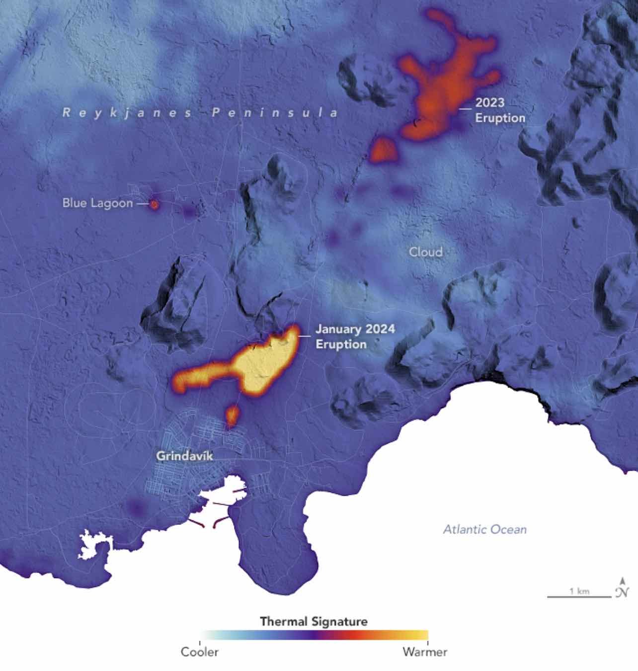
NASA satellite imagery has revealed the thermal signature of volcanic activity that reawakened on Iceland’s Reykjanes peninsula this month, following an eruption late last year that prompted evacuations.
Following a surge that began in mid-January, new fissures opened near the town of Grindavík that released lava over 48 hours. Barriers constructed in the area helped divert the flow away from the town, which remains perilous as volcanic activity continues.
The recent eruptions were the fifth that have occurred on the peninsula since 2021.
Watching from above as the hazardous activity has unfolded in recent weeks, NASA’s Landsat 9 satellite and its Thermal Infrared Sensor 2 (TIRS-2) instrument have collected data that reveals key areas where the volcanic activity is concentrated.
TIRS-2 can detect thermal radiation at two different wavelengths, which conveys the intense heat concentrated around areas where lava flows earlier this month made their way to the surface.
According to NASA’s Earth Observatory, which provides data, imagery, and resources related to climate, geology, as well as other Earth systems, TIRS-2 collected the thermal data as Landsat 9 passed overhead on January 16, which has now been superimposed over a digital elevation model of the affected region.
In the imagery provided by Earth Observatory below, the central warmest regions are shown in yellow, with surrounding the lightest temperatures in the region, shown in light blue, indicating cloud coverage.
(Credit: NASA/Earth Observatory)
In December, nearly 4,000 residents were evacuated from Grindavik, followed by a volcanic fissure eruption on December 18 on Sundhnúkagígaröðin, located east of Mt. Sýlingarfell, according to a statement provided by Iceland’s Meteorological Office.
The December eruption was preceded by a “powerful seismic swarm” that began at approximately 21:00 the same day.
Activity has continued since that time, with an additional fissure eruption that began on the morning of January 14, 2024, just one kilometer away from Grindavík. Although barriers constructed in the area since the recent eruptions began were able to divert some of the lava flow, a second fissure that opened shortly after noon local time erupted outside the barrier, resulting in lava flows that reached three homes on the edge of the town.
Fortunately, the volcanic activity subsided within 48 hours, according to the Icelandic Met Office. Although barriers have been used to prevent the flow of the lava from reaching residences during the recent eruptions, in decades past, efforts have included the use of millions of tons of sea water used to cool lava before it could destroy homes and infrastructure.
Based on current models, magma has moved beneath the region, causing uplift and deformation of the surrounding Earth.
“Clear signals of a continued land uplift are still being detected beneath Svartsengi,” read an update from Iceland’s Met Office on January 19. “It is yet too early to assert whether the rate of the land uplift has increased since prior to the eruption on January 14.”
The Met Office says that although it does appear that uplift has increased based on initial measurements, these readings “can fluctuate from one day to the next, and a longer timeline of measurement is needed to be able to interpret the long-term development of the land uplift.”
Fortunately, the Office says that seismic activity overall continues to decrease in the area and that current data suggests a “significant slow down of ground movement compared to previous days.”
“This information suggest[s] that magma is no longer flowing into the dyke and the eruption has ended,” the January 19 statement read.
Google Earth, although a useful locator tool, has on occasion boggled the minds of internet users who have stumbled across images of objects and scenes which appear to hold no logical explanation.
People are free to explore the planet in a few clicks of a button on the site, but some users have found themselves accidentally discovering chilling and disturbing sights.
Some UFO hunters claim the tool has captured proof of alien life while others have used the world mapping feature to investigate some of the spookiest areas on earth.
From 'lakes of blood' to 'undiscovered pyramids' in Egypt - ancient mysteries have been quizzed and questioned as internet users scratch their heads trying to unlock the truth behind the bizarre finds.
And it's not just creepy scenarios that have been unearthed on the virtual maps, but man-made installations too, from multi-billion-pound companies to local artists.
In one strange discovery, a portal to an ominous underworld was spotted tearing through an unknown street as onlookers gathered to watch.
Meanwhile, in another, a suspicious door buried in the deep snow of Antarctica seemed as if it could transport a visitor to the home of Bigfoot.
And if those weren't mind-boggling enough, a giant pentagram found on the ground in Kazakhstan sparked wild theories around satanism - but the truth was eventually revealed to be far more innocent.
Doorway to Bigfoot, Antarctica
A mysterious 'doorway' was spotted on Google Earth in Antarctica, just southeast of the Japanese-run Showa Station.
The bizarre discovery sparked a range of theories across the internet, including Bigfoot's vacation home or a shuttle from Star Trek.
The unusual structure was discovered by a Reddit user on Google Maps at the co-ordinate 69°00'50'S 39°36'22'E.
Posting to the forum, they wrote: 'Massive door in Antarctica?', along with the co-ordinates.
'Just a blown off Boeing door,' one user replied, while another wrote: 'That's actually Bigfoots vacation home.'
One user suggested it was the 'door to Agartha', while another claimed it could be a 'big seed vault like the one in Svalbard, Norway
Sadly, the structure's true identity is much less exciting than these theories might lead you to believe.
Professor Bethan Davies, a Professor of Glaciology at the University of Newcastle, looked at the coordinates on Google Earth Pro, allowing her to see historic imagery.
'This feature is in an area of fast sea ice in East Antarctica, just offshore of the coast,' she explained to MailOnline.
'There are a series of islands there and the water is pretty shallow.
'This is an iceberg that became grounded and is now stuck and melting out in situ. You can see many other icebergs in the area.'
A mysterious 'doorway' was spotted in Antarctica, just southeast of the Japanese-run Showa Station
Blood lake, Iraq
On the outskirts of Sadr City in Iraq there was once a blood-red lake that baffled Google Earth users.
Part of a stretch of water called Lago Vermelho, the lake runs through the city and is separated by sections of concrete and crossings.
It is within one of the central panels of water that the bright red color could be seen, giving the appearance of blood.
Speculation as to what may have caused the red coloring was rife at the time it was spotted by an eagle-eyed internet user, with some suggesting the lake was close to a slaughter house and the coloration was the result of dead animals being dumped there.
Others put forward the more sensible suggestion that the lake was near a sewage treatment plant, or perhaps water treatment was the cause of the colour.
But speculation aside, science offered a different explanation: tiny organisms.
In some salty lakes, special algae or bacteria can bloom, turning the water red.
A red lake in Iraq sparked fears it was filled with blood when it was spotted on Google Earth
Undiscovered pyramids, Egypt
This Google Earth image shows a seemingly sunken sand patch which some internet users believed could be an unexcavated pyramid.
The deep crater in the sand appears to be triangular in shape, leading some to the theory that this may be a monumental ancient Egyptian pyramid that has been missed by archaeologists.
Due to the nature of its position, and it's hole-like structure, the undiscovered pyramid is thought to have sank thousands of years ago, leaving a giant three-sided space in its wake.
Less than one percent of Egypt has been excavated, so there are almost certainly ruins we haven't found yet.
But an amateur satellite researcher from Maiden, North Carolina, in 2012 asked an Egyptologist what their thoughts were on the strange apparent pyramid.
'Looks to me more like the sand dunes have moved into the area and the local people were intent on saving some of the sites soon to be covered by sand. So they have kept up and excavation of this area for a reason.' the expert said.
'Looks to be something round sitting on top of a square feature. I think it may be an old well, like a lot of these features usually are. Or at least some sort of religious site that is being kept open by the locals'.
A bizarre triangle shaped crater in Egypt sent theories swirling that it could be an undiscovered pyramid
UFO landing tracks, England
There are bizarre structures discovered on US and British air bases, such as this one located near Norwich in England.
With its concrete base and rogue swirling patterns, alien-lovers across the internet claimed it could be a UFO landing track.
Seemingly placed in the middle of a field of sorts, with not many buildings around it, the mystery of what exactly the was home to deepened.
But despite the random, spaced-out designs, what is believed to be the truth behind the track was revealed almost a decade ago.
The area has been deemed a motorcycle range by the UK Ministry of Defense, though some believe it could potentially serve as a calibration mechanism for satellites.
What was thought to be a UFO landing track turned out to be a motorcycle range
Portal to the underworld, Unknown
Google Earth in 2018 captured a mysterious black space floating in the middle of a road.
The location of the unnerving siting remains unknown adding to the mystery.
Pictured, is what appears to be a typical construction site next to a public footpath.
Three people can be spotted; two older men are standing on the left with one man dressed in black and the other in a red coat.
A younger man appears to be about to the cross the road on the other side, BUT in between the men is a particularly ominous black hole.
After being posted online, internet users went wild with conspiracy theories, speculating that it could be a secret portal to the underworld.
But a more logical explanation later emerged.
As Google stitches images together, there a good chance this was just another Google glitch.
Or, perhaps, an oil spill from the heavy duty vehicles working on the construction site.
A glitch in Google Earth made it seem as if a portal to the underworld had opened up in the middle of the road
Crash-landed alien spaceship, South Georgia Island
Conspiracy theorists claimed to have spotted a 'crash-landed spaceship' in 2018 after a Google Earth image revealed a mysterious object buried in the snow on South Georgia Island in the South Atlantic Ocean.
Alien hunters were convinced it was of extra terrestrial origin but the truth would seem to lie closer to home.
Rather than evidence of little green men, it is the result of a large avalanche from a nearby mountain depositing a rock or large chunk of ice onto a glacier below.
Dr Richard Waller, senior lecturer in physical geography at Keele University, was behind the claim.
The unidentified mass was discovered near Antarctica on the remote South Georgia Island in the South Atlantic Ocean, where just 20 people live.
The avalanche is located in the upper part, known as the accumulation area, of the Novosilski Glacier, he said.
Speaking to MailOnline in 2018, Dr Waller explained: 'It looks to me as though this feature is related to a large avalanche from a nearby mountain.
'Part of a hanging glacier appears to have collapsed, you can see the avalanche debris at the foot of the slope, and this could be a large block of ice that has travelled further as a consequence.
'The track shows that it's sliding over a snow-covered glacier before it comes to a rest.'
Bizarre tracks could be seen running up behind the object, suggesting it slid through the snow for some distance before coming to a halt.
A Google Earth image revealed a mysterious object buried in the snow on South Georgia Island in the South Atlantic Ocean
Upon closer inspection, the object was revealed to be the result of a large avalanche from a nearby mountain depositing a rock or large chunk of ice onto a glacier below
The Pentagram, Kazakhstan
A giant five-pointed star etched into the ground deep in Kazakhstan sparked wild ideas after it was spotted on Google Earth.
As a symbol, pentagrams have a rich history across various cultures and religions, but conspiracy theories run wild, with some folks thinking it could be a sign of devil worship.
But as usual, the explanation is much simpler.
The massive star, captured within a circle, located near a lake close to the city of Lisakovsk, is actually the remains of an unfinished Soviet-era park.
Back when Kazakhstan was still part of the Soviet Union, stars were used on buildings, flags, and monuments across the country.
Archaeologists believe what happened on the ground near the popular lake followed that very tradition.
Roads were built to follow the star shape, and though the park was never completed, those roads are still visible from above, making the star stand out even more against the navy water.
Today, the site is abandoned and overgrown, adding to its creepy atmosphere.
The star-shaped etching in Kazakhstan appeared to be a satanic symbol, but the reason behind its creation is much more innocent
Bloody murder scene, Netherlands
In 2013, a Google Earth image prompted fears that it revealed a chilling and bloody murder scene.
The shot, which showed what looked like a trail of blood leading down a jetty in the Dutch city of Almere, sparking speculation a body had been dragged along it.
A shadowy, though unidentifiable figure is seen standing at the edge of the water in the shot, which was taken by a Google Earth helicopter.
However, an online sleuth revealed that is no grisly murder scene, but rather the work of a wet golden retriever called Rama.
Owner Jacquelina Koenen told The Sun in 2013: 'When I saw the picture I realised tt's my dog. He loves the water.
'He jumps off the end of the jetty, swims round to the bridge and runs down to the edge again.
'It's hilarious that everyone thought it was murder. But it's great he's now world famous.'
The paper added that local police confirmed Koenen's story, putting many people's mind at ease after believing they had seen a horror murder scene.
What seemed to be a bloody trail turned out to be the marks left behind by a soggy dog in Almere
The Gates of Hell, Turkmenistan
The Darvaza gas crater, also known as the 'Gates of Hell,' looks like a giant black hole in the middle of Turkmenistan's Karakum Desert.
But the 230ft wide hole has been on fire for over 50 years, after being created in 1971 when a Soviet drilling rig accidentally punched into a massive underground natural gas cavern, causing the ground to collapse and the entire drilling rig to fall in.
After puncturing a pocket of gas, poisonous fumes began leaking at an alarming rate.
In an attempt to avoid a potential environmental catastrophe, the Soviets set the hole alight, assuming it would stop burning within a few weeks.
But decades later it is still burning and the pit has become a major tourist attraction, drawing in around 10,000 visitors a year.
At night, the spectacle is truly awe-inspiring. The flames illuminate the night sky, creating an otherworldly atmosphere.
While the temperatures can reach up to 1,000 degrees Celsius, the flames burn without any smoke and offer a clear view of the inferno below.
Turkmenistan's government has considered putting out the fire due to environmental concerns and the waste of valuable natural gas, but the Gates of Hell continue to burn to this day.
The Gates of Hell in Turkmenistan appears as a mysterious black hole in the middle of a barren desert on Google Earth
In reality, the crater is lit up by an orange blaze that has been alive for over 50 years
Billionaire's name in sand, UAE
Hamad bin Hamdan al Nahyan, a billionaire Sheikh and a member of Abu Dhabi's ruling family, had his name etched into the sand on the island of al Futaisi, which he owns.
The name is written half a mile in height and two miles in length and is allegedly visible from space, with Google Earth imagery capturing the deep lettering stretching through a sandy area and into the ocean.
Whereas the sea would typically wash away any markings in the sand, these letters are so huge they form waterways that fill with the tides but do not vanish.
Images show the word 'HAMAD' gradually turning blue as the seawater seeps into the giant etchings.
The name HAMAD can be seen etched into sand in the UAE
KFC space logo, Nevada
From space, extraterrestrials and astronauts can look back to earth and see The Great Wall of China -- and KFC's Colonel Sanders.
The KFC Corp. in 2007 launched a rebranding campaign with an 87,500 square-foot image of Colonel Sanders in the Nevada desert which the company said makes Kentucky Fried Chicken the world's first brand visible from space.
'If there are extraterrestrials in outer space, KFC wants to become their restaurant of choice,' KFC President Gregg Dedrick said in a statement.
The logo consists of 65,000 one-foot by one-foot painted tile pieces that were assembled like a giant jigsaw puzzle.
'If we hear back from a life form in space today - whether NASA astronauts or a signal from some life form on Mars - we'll send up some Original Recipe Chicken,' said Dedrick.
The logo also depicts an updated version of KFC icon Colonel Sanders who wears his signature string tie but with a red apron instead of his classic white double-breasted suit.
The logo was built at the remote Area 51 desert near Rachel, Nevada, which KFC said was known as the UFO capital of the world and famous for its association with UFO conspiracy theories.
The KFC Corp. in 2007 launched a rebranding campaign with an 87,500 square-foot image of Colonel Sanders in the Nevada desert
The Boneyard, Arizona
The Boneyard appears on Google earth as unbelievably large green space filled with hundreds of abandoned planes.
Although they may seem like toy figures, the aircraft dumped on these grounds are in fact, real.
The Boneyard is the largest plane cemetery in the world, and is located in Tuscon, Arizona.
The site's massive size is equal to an astounding 1,430 football fields, providing ample space for the extensive collection of over 4,000 retired aircraft.
The Boneyard, also known as the 309th Aerospace Maintenance and Regeneration Group, annually receives 300 aircraft for storage and processes out about the same number (with 50 to 100 of those returning to flying service).
Aircraft that fly again either return to the US military, US government agencies such as the US Coast Guard, US Forest Service, and NASA, or are sold to allied governments under either the Foreign Military Sales program of the Arms Export Control Act, or the Excess Defence Articles program of the Foreign Assistance Act.
The Boneyard, located in Tuscon, Arizona, is the largest plane cemetery in the world
Scarecrow Village, Japan
One Google Earth user was left baffled after stumbling across a village of scarecrow people in Nagoro, Japan.
Once a bustling community, the village has an ever shrinking population, except from the 300 life-sized scarecrows that are dotted around the area.
Their faces seem so real that Google has blurred them out in its digital maps.
The bizarre scarecrows were created by a local artist named Tsukimi Ayano and allegedly resemble past villagers or imagined characters.
They have been set up by Ayano to make them appear as if they are tending to gardens, fishing by the river, or even waiting for a bus.
She stuffs old clothes with newspaper and cotton wool to make the plush figures that ca be seen on Google Earth placed around the village.
Ayano even started creating dolls that follow international trends.
Visitors can play a game of real-life 'Where's Waldo,' and can attempt to find the US President Donald Trump scarecrow doppelganger or characters from the Harry Potter series.
There are also famous Japanese celebrities and comedians.
On the first Sunday of October, Nagoro holds a festival that exhibits the scarecrows and Ayano's other works.
She’s just one of approximately thirty people still living in the village.
One Google Earth user was left baffled after stumbling across a village of scarecrow people in Nagoro, Japan
Local resident and artist Tsukimi Ayano making the head of a life-size doll at her house in the tiny village of Nagoro
Eerie images show the life-sized scarecrows dotted across the village
The dolls are made to appear as if they are carrying out everyday human tasks
Floating forest, Australia
Seen on Google Earth as what looks like a floating forest is the shipwreck of SS Ayrfield.
It lies deep in the heart of Sydney, Australia, and over time has been consumed by nature - turning it into a haunting relic.
The large silhouette of the ship appears on the map to be a lonely island, but in reality, it marks an abandoned piece of history that has been left to the elements.
Built in 1911, the SS Ayrfield spent its life hauling cargo up and down Australia's coast.
But by 1972, its working days were over. It was sent to a scrapyard in Homebush Bay –but they never finished the job.
Over the years, a vibrant mangrove forest established itself within the rusting hull of the wreckage, creating an incredible visual contrast with the dark waters below.
The deteriorating ship has over time been transformed into the floating forest seen from above today, and the natural reclamation has turned the SS Ayrfield into a popular destination for photographers and tourists, providing a unique view of the interaction between human history and nature.
Google Earth shows the SS Ayrfield shipwreck appearing as a small island near Australia
The wreckage has been left to the elements and the vessel is now covered in trees
The SS Ayrfield sits on the shallow harbour bottom with mangroves growing out of her rusting shell
Amazing Encounters with Strange, Mysterious, and Mystical Lost Tribe
Brent Swancer
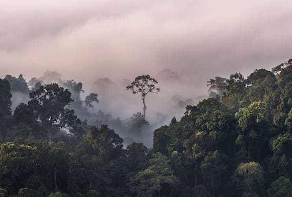
History holds many oddities that we may never fully understand, either through incomplete documentation, disinterest at the time, or simply a big question mark that hangs over all. Among these are mysterious lost tribes of people that have been encountered and confronted in all corners of the globe, often vanishing before we really understand them or only known from sparse accounts, and leaving us perplexed at just who they were or where their origins lie. Here we will look at mysterious lost tribes of ape-men, blue-eyed Indians, mystical tribes with telepathic powers, and more.
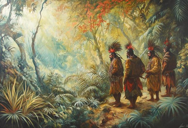
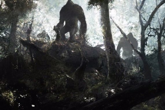
The remote jungles of South America have long been the source of tales of strange creatures and legends, and among these are numerous sightings of a tribe of large, ape-like beings living in the wilderness. The descriptions of these creatures often vary, with sizes ranging from a diminutive 3 feet tall all the way up to hulking, 12-foot-tall hairy giants, and are often claimed by the natives of the region and witnesses to live in villages of their own, to use tools and primitive bows and arrows, and to have a language of grunts and whistles. Although regional names may vary, they are now mostly filed under the blanket name Maricoxi, and they are for the most part more or less a complete enigma.
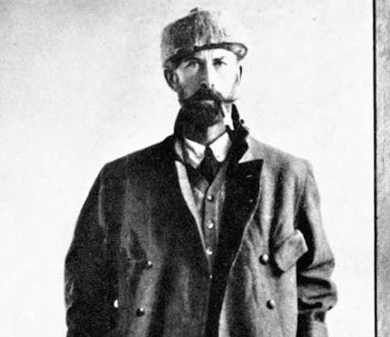
Perhaps one of the most well-documented and harrowing encounters with these mysterious creatures was detailed by the famed British explorer Colonel Percival H. Fawcett, more often called Percy Fawcett, who vanished into the jungle during an ill-fated expedition to find a mysterious lost city he called simply Z. Fawcett was known to write extensive journals of his travels, many of which would later be compiled into books by his son Brian Fawcett. In one of these books, called Lost Trails, Lost Cities, there is to be found within its pages a rather curious and spectacular tale of encountering the Maricoxi.
Percy Fawcett
The encounter supposedly happened in 1914, as Fawcett was on an expedition to map out the uncharted southwestern region of an area called Matto Grosso. From Bolivia they penetrated the dark jungle up the Guapore River, and already they had become well acquainted by local tribes with the bizarre stories of hairy man-beasts said to dwell out there in that sea of trees, and although it seemed rather fantastical it was enough to keep them wary of their surroundings and what they would find out there on their journey. Ivan Sanderson wrote of the stories Fawcett heard in his 1967 book Things, in which he writes:
“These creatures were apparently called Maricoxis by the Maxubis. They dwelt to their northeast. Due east there were said to be another group of short, black people, covered with hair, who were truly cannibalistic and hunted humans for food, cooking the bodies over a fire on a bamboo spit and tearing off the meat. These the Maxubis regarded as merely loathsome and lowly people. On a later trip, Colonel Fawcett was told of an "ape-people" who lived in holes in the ground, were also covered with dark hair, and were nocturnal, so that they were known in surrounding areas as the Morcegos or Bat-People. These types are called Cabelludos or "Hairy People" by the Spanish-speaking, and Tatus, or armadillos, by several Amerindian groups because they live in holes like those animals. Fawcett also records forest Amerinds as telling him that the Morcegos have an incredibly well-developed sense of smell which prompts even these acute hunters to suggest that they have some "sixth sense.”"
They nevertheless bravely ventured out along the river, coming across some oddities along the way. The first interesting discovery was a previously unknown Amerindian tribe, who identified themselves as the Maxubis and displayed some curious traits, such as their religion of worshiping the Sun and demonstrating an inexplicable knowledge of the planets of the solar system, which they could draw out with rather shocking accuracy. This would have been interesting to have studied further, but Fawcett and company were not there to do anthropological work, and after staying with the tribe for a few days they headed back out into the mist-shrouded jungle once more, leaving these fascinating people behind to the mist of history and crossing over into a region that was completely unseen by outsiders and ws so remote and alien it may as well have been the surface of some alien planet.
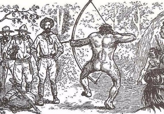
After several days of dealing with the numerous perils of this untamed land, the expedition found themselves faced with a mysterious trail out there in the middle of nowhere, which they presumed to be one used by the Natives of the region. As they stood there deciding whether to follow the trail or not and which way to go, Fawcett writes that they saw two figures moving about 100 yards away, apparently chattering away in some unknown language and carrying bows and arrows. Although they were at first presumed to be from a local tribe, closer inspection showed them to be decidedly odder, and Fawcett described them:
“We could not see them clearly for the shadows dappling their bodies, but it seemed to me they were large, hairy men, with exceptionally long arms, and with foreheads sloping back from pronounced eye ridges, men of a very primitive kind, in fact, and stark naked. Suddenly they turned and made off into the undergrowth, and we, knowing it was useless to follow, started up the north leg of the trail.”
It seems quite obvious by this point that Fawcett did not regard what he had glimpsed as completely human beings. This was perhaps all odd enough as it was, but it got even more bizarre that evening at dusk when the forest suddenly came alive with the sound of what seemed to be braying horns from out in the distant dark. The expedition members were immediately on alert, as they instinctively knew that this was an aggressive sound issued forth with the promise of threat. Fawcett would write of these horns and what followed:
“In the subdued light of evening, beneath the high vault of branches in this forest untrodden by civilized man, the sound was as eerie as the opening notes of some fantastic opera. We knew the savages made it, and that those savages were now on our trail. Soon we could hear shouts and jabbering to the accompaniment of the rough horn calls--a barbarous, merciless din, in marked contrast to the stealth of the ordinary savage.
Darkness, still distant above the treetops, was settling rapidly down here in the depths of the wood, so we looked about us for a camping site which offered some measure of safety from attack, and finally took refuge in a tacuara thicket. Here the naked savages would not dare to follow because of the wicked, inch-long thorns. As we slung our hammocks inside the natural stockade we could hear the savages jabbering excitedly all around, but not daring to enter. Then, as the last light went, they left us, and we heard no more of them.”
It is an eerie image to be sure, this solitary camp of bedraggled explorers terrified by the sight of hairy men and now harassed by these mysterious horns in the night, punctuated by the chattering of some rough, alien language, and it was still not over for them. The next morning the team warily checked their surroundings and could find no sign of any of the “savages” having intruded into the vicinity. They continued along one of the well-delineated trails they were finding and camped once again that evening without incident. The next morning, they struck out from the camp and within just about a mile stumbled across what seemed to have been the actual village of the strange tribe, populated by creatures who were obviously not exactly human. Fawcett rather spectacularly describes what happened:
“In the morning we went on, and within a quarter of a mile came to a sort of palm-leaf sentry-box, then another. Then all of a sudden we reached open forest. The undergrowth fell away, disclosing between the tree boles a village of primitive shelters, where squatted some of the most villainous savages I have ever seen. Some were engaged in making arrows, others just idled--great apelike brutes who looked as if they had scarcely evolved beyond the level of beasts.
I whistled, and an enormous creature, hairy as a dog, leapt to his feet in the nearest shelter, fitted an arrow to his bow in a flash, and came up dancing from one leg to the other till he was only four yards away. Emitting grunts that sounded like 'Eugh! Eugh! Eugh!' he remained there dancing, and suddenly the whole forest around us was alive with these hideous ape-men, all grunting 'Eugh! Eugh! Eugh!' and dancing from leg to leg in the same way as they strung arrows to their bows. It looked like a very delicate situation for us, and I wondered if it was the end. I made friendly overtures in Maxubi, but they paid no attention. It was as though human speech were beyond their powers of comprehension.
The creature in front of me ceased his dance, stood for a moment perfectly still, and then drew his bowstring back till it was level with his ear, at the same time raising the barbed point of the six-foot arrow to the height of my chest. I looked straight into the pig-like eyes half hidden under the overhanging brows, and knew that he was not going to loose that arrow yet. As deliberately as he had raised it, he now lowered the bow, and commenced once more the slow dance, and the 'Eugh! Eugh! Eugh!’"
This brutish ape-man allegedly continued to do this several more times, aiming the bow only to continue with his odd, disjointed dance and then aim it again. However, Fawcett seemed to know that at any point that arrow could unleash, and his hand was firmly kept upon the butt of his pistol as he took in the whole outlandish scene. At some point Fawcett says he began to seriously fear for his life and decided to try scaring it off with his sidearm, shooting off a round that pinged the earth by the beast’s feet and sent a thunderous boom echoing through the jungle. He says of this sequence of events:
“I drew out a Mauser pistol I had on my hip. It was a big, clumsy thing, of a caliber unsuitable to forest use, but I had brought it because by clipping the wooden holster to the pistol-butt it became a carbine, and was lighter to carry than a true rifle. It used .38 black powder shells, which made a din out of all proportion to their size. I never raised it; I just pulled the trigger and banged it off into the ground at the ape-man's feet.
The effect was instantaneous. A look of complete amazement came into the hideous face, and the little eyes opened wide. He dropped his bow and arrow and sprang away as quickly as a cat to vanish behind a tree. Then the arrows began to fly. We shot off a few rounds into the branches, hoping the noise would scare the savages into a more receptive frame of mind, but they seemed in no way disposed to accept us, and before anyone was hurt we gave it up as hopeless and retreated down the trail till the camp was out of sight. We were not followed, but the clamor in the village continued for a long time as we struck off northwards, and we fancied we still heard the 'Eugh! Eugh! Eugh!' of the enraged braves.”
This account may seem to be completely sensational to the point that it might be easy for the more skeptical-minded to dismiss it out of hand, but there are a few reasons why it has warrant and deserves consideration, the first being that this was likely not some fictional story Fawcett was telling. It was part of his very serious and typically meticulous notes on his expedition and sitting right there amongst more mundane observations of the wildlife and region’s various peoples. He was a consummate professional and member of the Royal Geographical Society, as well as a very respected, experienced explorer and surveyor, and there is no rational reason at all for why he should want to concoct such a story to drop in the middle of his otherwise meticulous journal. Why would he do that and risk his reputation? To what ends? It also means he would not likely have made misidentifications of local tribes or wildlife, as he was as familiar with these jungles as one could possibly be in the era.
Fawcett has also been accused of having perhaps exaggerated his dealings with the Natives and in this case, made them out to be hairy brutes out of some racist agenda, but if that were the case then why are there other records of his dealings with locals that are completely accurate in their depiction of their appearances and behavior? It is somewhat true that Fawcett was known to have some strong opinions on the more primitive tribes, but he seems to have never let it compromise the matter-of-fact way in which he recorded the people themselves. Sanderson has much to say about this aspect of the journal entries, writing:
“He (Fawcett) was not an ethnologist, anthropologist, or archaeologist but it was with these disciplines that he clashed, and it was towards the protagonists of the first that he most often expressed himself as feeling most bitter. In his extensive travels through hitherto unexplored territories he discovered many groups of people for the first time, lived with them, often acquired not a little of their language, recorded what of their customs he could, and attempted some classification of their origins. Much of all of this conflicted with established beliefs among ethnologists, and Fawcett's historical theories were at complete variance with what was then, and still is, accepted. Yet, while those theories were strongly criticized, the veracity of the facts he collected were never questioned. It was his assessment of them that was considered invalid.
This puts his account of the hairy Maricoxis in an entirely different light, quite apart from the fact that his word was never doubted, that he had two reliable witnesses, and that what he saw was both before and afterwards confirmed by others, in that reports relayed to him by several people described exactly what he had seen without the relaters knowing anything of what he did see. We are therefore compelled to accept this report in toto; and this means simply that, in the year 1914, there were living to the northeast of the Parecis Range in the Matto Grosso, what were apparently tribal groups of fully-haired hominids of grossly primitive aspect, and in no possible way descended from or related to the Amerindian aborigines of the Americas.”
While Sanderson may seem perhaps too quick to buy the whole tale, it certainly is an account that stands out among Fawcett’s writings, and which ultimately leaves more questions than answers. What did Fawcett and his fellow expedition members encounter out there in that jungle? Were these indeed the legendary Maricoxi or something else? It is truly unfortunate that considering that Fawcett was not particularly interested in following up on it, and seems to have considered it mostly an obstacle and oddity, he never did make any effort to find out what they were, and the creatures of his account just sort of fade into the background to remain perplexing enigmas. Did this tribe of hairy ape-men really exist the way Fawcett described them, and if so what were they and how did they fit into the Maricoxi legend? The answer may forever remain hidden out there in that forbidden jungle lair.
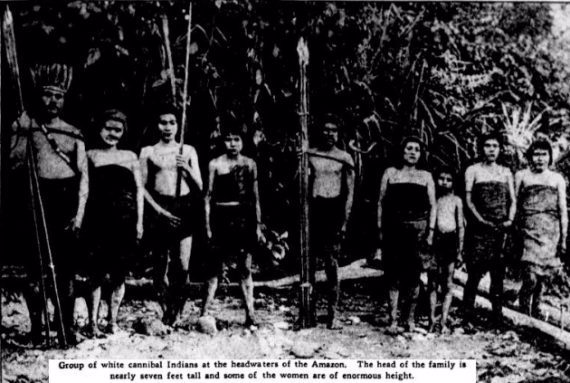
Besides tribes of man-like apes, one persistent legend that has been around since 16th-century Spanish missionaries came to the Amazon region is that of tribes of tall, fair-skinned, blonde, blue-eyed, decidedly Caucasian-looking natives living out in the most remote and inaccessible areas of the jungle. One of the earlier accounts of encountering these mysterious people was made by the Spanish Dominican missionary Gaspar de Carvajal, who wrote in 1542 of coming across a group of very tall, very white, European-looking tribal women who wore their long, light hair braided and wound about their heads. The account was included in his book Account of the Recent Discovery of the Famous Grand River.
Supposed photo of "white natives" taken in the Amazon
Another popular account of these white Amazonians comes from the American explorer Alexander Hamilton Rice, Jr., who journeyed into the Amazon for a 1924-1925 expedition. Upon returning from the perilous expedition, Rice told of one of the expedition members, a Lieutenant Hinton, who had spied a tribe of white Indians while making a flight over the headwaters of the Parima River. Intrigued, Rice organized a trip by canoe up the river in order to try and find out where the mysterious white natives came from. Eventually, they located a hut that was believed to belong to the white Indians, and they then heard a series of shrieking yells which scared some of the expedition members off and put the remaining group on edge, reaching for their weapons. It was then that two of the white natives came out of the forest, apparently in peace.
These white-skinned natives were described as having pigment painted across their faces that obscured their features, but they were said to be “undeniably white.” The two were said to look undersized and undernourished, wore no clothing, and carried with them bows with poison-tipped arrows. They spoke in a unique language not known to be spoken by any other tribe, which made communication difficult. When the expedition members offered beads and handkerchiefs as gifts, the two tribesmen reportedly called out into the jungle, which brought more of the fair-skinned natives out of hiding.
These odd, white tribespeople were offered food, but it was declined, and it seemed that they preferred to eat plantains which had curiously been garnished with cocaine, although it was unclear where they had acquired the drug. Throughout the encounter, the strange tribe showed no particular interest in or awe of the Westerners’ clothes, equipment, guns, or hydroplane. The expedition made further efforts to try and communicate with the tribe, but the language barrier made it difficult, and after a while the white Indians melted away back into the forest, moving “between the trees like jaguars without making a sound or causing a rustle of the leaves.”
The 1920s were indeed a period of many sightings of these white-skinned natives, and feature heavily in accounts from the explorer Percy Fawcett, who was convinced that these people were denizens of a mystical lost city deep in the jungle, which he called simply “Z.” So convinced was he that this mystical city and its people existed that they would inevitably lead him to obsession and lure him to his final, ill-fated expedition in search of the city of Z in 1925. Fawcett would journey out into uncharted jungle in search of his fabled city and seemingly step off the face of the earth. No trace of him or his expedition was ever found.
Accounts and sightings of the white natives continued sporadically into the 1940s, and in 1945 the British Journalist Harold T. Wilkins took it upon himself to compile a variety of reports stretching back to the 16th century in his book Mysteries of Ancient South America. Even in modern times, there have been accounts of coming across these enigmatic people. In 1977 one joint British/ Brazilian expedition reported being surrounded by a tribe of uncommonly tall, blonde natives with blue eyes and strikingly white pigmentation, some of who had thick beards and all of who were naked. The strange white tribesmen allegedly spoke a dialect that no expert had ever heard before. These people were called the Acurinis and were again encountered by another expedition to the same region in 1979. In this case, the mysterious tribesmen were seen only briefly before vanishing into the underbrush.
Theories abound over what could be behind these accounts. One is that they are the descendants of shipwrecked sailors, Vikings, lost explorers, or even missionaries or other Westerners who willingly left civilization behind to live amongst the natives, where they invariably intermingled. Indeed there are theories that Percy Fawcett himself did this and that the descendants of both him and his expedition members may be behind some of these encounters with fair-skinned natives. In recent years there has been one tribe called the Aché, who are known for having light skin, hair, eye color, and thick beards, and although it has been shown that they show no genetic evidence of having ever mixed with Europeans, their unique appearance could make it possible that they might be the source of at least some of the accounts. It is unlikely we will ever know for sure the precise origins of these stories.
One very odd account that comes from the Amazon wilds is that of an intrepid explorer who came here looking for mysteries and would soon get more than he bargained for, embarking on a quest that would include lost, uncontacted tribes and strange powers of the mind. Loren McIntyre was a seasoned explorer, photojournalist, and writer for such esteemed publications as National Geographic, Time, Life, Smithsonian, GEO, Audubon, and South American Explorer, and was in many ways a sort of real-life Indiana Jones figure, spending much of his life doggedly exploring the forbidding, uncharted, and most impenetrable reaches of the Amazon rainforest of South America. Indeed, it was he who would be the first one to discover the source of the mighty Amazon River, when he made an expedition in search of it in 1971. He would make history when he found that the largest, longest, and most powerful river in the world began with a runoff of snow at a mountain in the Andes called Mismi, some 6,400 kilometers from the Atlantic Ocean, which trickled down to pond now called Laguna McIntyre, which in turn emptied into a brook named Carhuasanta, in Peru, after which it began its inexorable growth and meandering journey through some of the most remote wilds on earth. Yet, although this is McIntyre’s most famous discovery it certainly wasn’t his only one, and he would have a very mysterious encounter out in those jungles that he would keep to himself for years.
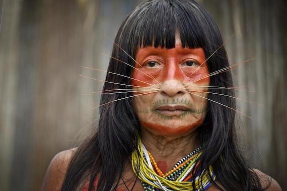
In 1969, McIntyre embarked on an excursion into the unexplored depths of the Amazon jungle of Brazil. His target was the little-known Mayoruna tribe, also called the Matsés, who were so elusive that they had never been successfully contacted by outsiders and were known as “The Cat People,” due to the arrays of imposing spikes that they wore implanted into their faces. Next to nothing was known about this enigmatic tribe, and they were only ever fleetingly glimpsed. They were like ghosts, and McIntyre had little to go on when he was dumped off on the shores of the Amazon River in a place called the Javari valley, on the border between Brazil and Peru, and left to continue on his own, penetrating dense jungle that no outsider had ever set eyes on in an attempt to find these mysterious people. Little did he know that it would be they who found him.
As the brave, seasoned explorer made his way through a mosquito-infested jungle he got perhaps too focused on finding the lost tribe, and soon realized that he was hopelessly lost. His journey then turned into aimlessly wandering through the perilous wilderness, and it became obvious that he was not going to be in time for his scheduled pick-up at the point where he had been dropped off. He began to resign himself to the fact that he just might end up another mysterious lost explorer, like his childhood idol Percy Fawcett before him, a fellow explorer who had mysteriously vanished while looking for his mythical city “Z.” Making this trek more ominous was when at some point McIntyre would stumble across a clearing littered with the bodies of what appeared to be four lumberjacks, half devoured by ants and with arrows sticking out from their silent corpses.
This grim discovery had the explorer watching the trees carefully as he aimlessly wandered around half expecting death to come for him at any moment through the shadows, and more sure than ever that he would not see civilization again. It was as he was in this fog of panic and fear that some figures crept out of the forest before him, spikes embedded into their faces, necklaces made of bones, possibly human, around their necks, and looking upon him with a mixture of apprehension and surprise, but not aggressiveness. These were the Mayoruna, and this was the closest any outsider had ever gotten to them. At least any who were still alive.
The frightened explorer immediately and very slowly pulled out some gifts that he had brought in the event that he actually made contact. From his bag, he produced some cloth and mirrors, which he dropped before the tribesmen as they looked on with inscrutable expressions on their pierced faces. They stepped closer to accept the gifts and then seemed to beckon for him to follow them as they began to melt back into the forest. The weary McIntyre stumbled after them, barely able to keep up with their nimble navigation of the jungle, and so would begin the next chapter of his strange adventure.
They arrived at what seemed to be a makeshift camp full of other members of the tribe, and they seemed to show a strange mixture of curiosity and aggression toward him. Upon examining his tennis shoes they went about burning them to ashes, and his watch they found fascinating, but they destroyed that too. Indeed, most of his possessions would be either stolen from him or destroyed, and even his camera, which they oddly showed no interest in, was broken when a monkey descended from the trees to take it from him. Although there was no outright aggression against him, there were some grim reminders that he was very much in danger. He would claim that they possessed trinkets made of human bone and that they drank out of hollowed-out skulls. They were also very well armed and never far from their bows, and one tribesman with red face paint, who he called “Red Cheeks,” took to menacing him and scowling at him.
McIntyre would end up staying with this lost tribe for two months, and during this time made many observations. He noticed that they were constantly on the move, perpetually moving to a new camp, sometimes suddenly and without warning, and they clearly had a hunter-gatherer lifestyle. They also seemed to have no concept of individual possessions, freely sharing everything with each other and taking or using whatever they liked without repercussions. Even odder still, he noticed that these people often moved quite bizarrely in sync, knowing what the others would do or acting in precise tandem without speaking to each other. For some time, he pondered this anomaly, but he would soon learn that the explanation was far odder than anything that he had ever guessed at.
One day he was approached by the one he took to be the chief of the tribe, an ancient-looking, sinewy and grizzled tree trunk of a man, covered in warty growths that would earn him McIntyre’s nickname “Barnacle.” When the chief approached he spoke to McIntyre, and the explorer found that bizarrely, after weeks of being unable to understand anything any of them had said, he clearly comprehended what Barnacle had to say. This utterly perplexed him, but he soon realized that this chief was not moving his mouth when he spoke, and that he was talking directly into his mind, using a sort of telepathy that McIntyre would later call “beaming,” and which Barnacle called “the other language.”
Barnacle explained that the tribe existed as a sort of hive mind consciousness and that their thoughts were all linked to each other, although only the tribal elders were proficient at focusing this telepathic power and truly using it to its full potential. Here he learned that there was no real “self” as Westerners would think of it and that to them the concept of an individual “self” made little sense. The chief also telepathically explained that they were under constant threat from loggers and other outsiders and that the reason the tribe moved so often was that they were on a spiritual journey to what he called “The Beginning,” or the literal beginning of time, where they hoped to be beyond the reach of the intruding outside world. Indeed, the tribe seemed to have a very strange grasp of how time worked that was rather alien to anything the explorer was familiar with. A 1991 article in The Los Angeles Times about McIntyre’s bizarre experience explains the tribe’s philosophy on time as follows:
“The main feature of time, by western definition, is its passage. But for the Mayoruna, time is at once mobile and static. It moved with man, stopped with him, advanced and retreated with him. It is not the implacable judge, condemning man to a tragically brief life. Time is a shelter, an escape into safety and regeneration, a repository whose chief function is not piling up the past, intact yet dead, but rather keeping it alive and available. And, in the face of violent encroachment on their land by white settlers, that past assisted them with an alternative to a menacing present.”
The chief invited McIntyre to come along with them on their journey to “The Beginning,” and for the next few weeks he followed them on their mystical quest and engaged in their rituals, often taking psychoactive jungle concoctions that warped his perceptions. He found that if he concentrated he could pick up on a sort of static fuzz that contained the interlinked thoughts of all of the tribe members, through processes he could never hope to fathom. However, he knew at some point he would have to part ways with them and try to leave this land of jungle, telepathy, and time travel behind him to get back to the civilization that was no doubt convinced he had vanished. The only problem was that he had no idea where he was, and on top of this, although he had been invited and was not physically threatened by the Mayoruna in any way, he had no illusions that he was anything other than their prisoner and wondered what they would do if he tried to flee. However, in the end, the decision was made for him, a flood swept through during a torrential rain, and McIntyre was whisked away as he clung to a balsa raft, emptied into the river and incredibly found the next day by a pilot flying over.
Upon getting back to civilization, McIntyre would keep what had happened to him a secret for years, and it is quite likely that the whole fantastical tale would have died with him in 2003 if it hadn’t been for a Romanian-American writer, director and movie producer, by the name of Petru Popescu. In 1987 Popescu met McIntyre by chance while on a riverboat trip up the Amazon River. The two men hit it off, and for some reason McIntyre confided to him about what had happened all of those years ago with the mysterious Mayoruna tribe. It was all rather amazing, and when Popescu asked why he had never told anyone about it, McIntyre said that he didn’t think anyone would ever believe him, and he had been worried about maintaining his reputation as a respected explorer, writer, and photographer. He would say of this:
“I’m pretty reluctant to voice very much about the beaming experience because I didn’t want my friends to think I’d gone around the bend. ‘What is this? The guy’s hallucinating?’”
Popescu would finally manage to convince McIntyre to let him write a book on his adventures, and in 1991 released The Encounter: Amazon Beaming. The explorer would claim that in his dealings with dozens of other tribes in the same region he had never before or since experienced anything like he did during his time with the Mayoruna, and he did not know what became of them. We are left to wonder just how much of this account is true, and if it is just what was going on with these elusive people of the jungle. The tribe itself has sort of disappeared, they have never been formally studied, and since McIntyre passed away in 2003, we are left only with Popescu’s book as a window into this strange tribe and their world and ways. One wonders if they are still out there, or if they managed to make that journey to “The Beginning,” finally at peace and forevermore out of our reach.
The Amazon is not the only place for such stories, and one tale of a mysterious lost race comes to us from the Appalachian Mountains of the United States, it tells of a strange race of albino, sun-fearing pygmies who supposedly roamed this land long before even the Natives arrived. In the untamed wildernesses along the Southern Appalachian Mountains of the United States, the Native Cherokee people have long told of a strange race of beings they call “The Moon-Eyed People.” This mysterious tribe was supposedly smaller than average humans, almost dwarfish in nature, very pale skinned, like pure white alabaster, with shocking white hair, generous beards and body hair, and inhumanly large blue eyes, sensitive to light to the point that they were said to be unable to see in the daytime, hence their name. These Moon-Eyed people were purportedly completely nocturnal, hiding in dank caves and underground caverns during the day only to come out at night when the sun had retreated, and indeed sunlight was said to be enough to kill them if they ever got caught out in the open during daylight hours.
These strange, diminutive nocturnal denizens of the land were said to have been here long before the first Native peoples had settled the area, and according to most legends, they were eventually expelled by local Natives, although what form this expulsion takes varies from tradition to tradition. In some tales, it was the Creek people from the south who cast them out, whereas in others it was the Cherokees themselves who waged a relentless campaign and full-out war against these pale-skinned creatures to drive them to other lands. The American botanist, naturalist, and physician, Benjamin Smith Barton, wrote of these people and their downfall back in 1797, in his book New Views of the Origin of the Tribes and Nations of America, thus:
“The Cheerake tell us, that when they first arrived in the country which they inhabit, they found it possessed by certain 'moon-eyed-people,' who could not see in the day-time. These wretches they expelled.”
Whatever happened to this enigmatic race, their legacy has supposedly remained behind in the ancient rock structures and mysterious pre-Columbian mounds and ruins that dot the landscape along the Appalachians from North Carolina all the way down through Georgia and Alabama, all said to have been erected by the Moon-Eyed People. Perhaps the most famous of these is an 850-foot-long stone wall dated to 400 - 500 C.E., which meanders through Fort Mountain State Park, just over the North Carolina border in Georgia, and is said to be a vestige of the bloody war between the mysterious Moon-Eyed People and the native Cherokee. There are countless other crude rock structures, walls, mounds and forts scattered throughout the Appalachians, as well as anomalous carvings, figurines, and a soapstone carving of conjoined figures now on display at the Cherokee County Historical Museum, said to be of these strange people, and no one really knows who made any of them except for the Cherokee themselves, who say it was the work of the Moon-Eyed People.
Whoever built such structures has long remained a mystery, and when Europeans first came to the region the Natives, who were not known for making such fort-like structures themselves, claimed that they had always been there, saying that they were constructions of the Moon-Eyed People. Interestingly, while Cherokee folklore has many tales of supernatural beings and various spirits, the Moon-Eyed People are never spoken of in such a manner, rather being described matter-of-factly as physically another race inhabiting the same lands.
Of course, with such an oddity as a cryptic tribe of bizarre dwarf subterranean albino people, almost like vampires in their intolerance for sunlight, and who predated the native peoples and constructed their mysterious mounds and forts, there is bound to be theorizing as to who or what they may have been. One of the most popular ideas is that they are evidence of Native contact with European explorers who had made it to the New World long before history says they did, possibly connected to the legend of the “Welsh Speaking Indians.”
The story of white-skinned, Welsh-speaking Indians in the New World originates with a 16th-century manuscript published by Welsh antiquarian Humphrey Llwyd, in which he writes of Welsh settlers coming to these shores in the 12th century, in particular a Prince Madoc, who along with his followers was said to have emigrated to America from Wales in about 1170, landing somewhere in the vicinity of Mobile Bay, Alabama. Madoc would supposedly end up shipping over hundreds of his followers to the New World, where they would disappear into the wilderness, never to return. In the following centuries, there were many stories of fair-skinned, blue-eyed natives who spoke a form of Welsh from the area, and these have been speculated to have been the descendants of these settlers.
Another idea put forth by Benjamin Smith Barton is that they were out-of-place descendants of members of the Guna people of Panama, who have such an uncommonly high rate of albinism that they were once referred to as the “White Indians,” and who were also reportedly able to see better at night. Another theory is that, rather than go to war, the Natives of the land actually integrated with the Moon-Eyed People and absorbed them. Still other more far-out theories are that these were some other species of human, a new race, or even ancient astronauts from another world.
It is still unclear who or what the Moon-Eyed people may have been, and they remain a distinctly enigmatic lost civilization if they ever even existed at all. Who were these albino, sun-fearing people? Were they some lost race, descendants of pre-Columbian explorers, or even a new species or alien interlopers? Or were these just a figment of folklore and myth? The answers to such questions remain obscure, but the tales of the Moon-Eyed People have persisted for over a millennium, and the idea that such a race of lost humanoids has been lost to history captures the imagination.
Another such “blue-eyed tribe” appeared to explorers as something quite European in nature, although their ways and beginnings have always been cloaked in shadows. Known mostly from historical accounts, their origins remain murky, their lineage uncertain, and they are a historical curiosity we may never fully understand. During the era of early European contact, the native peoples of North America held many curiosities for explorers and settlers coming to this new, wild land. These tribes were numerous and displayed rich variety between different cultures, as well as myriad languages, customs, and traditions that inspired awe, wonder, curiosity, bafflement, and even fear in the European adventurers who bravely delved into this uncharted new world and tried to tame it. Yet as fascinating as these new peoples were, perhaps the most interesting was an alleged tribe of natives who were said to look decidedly Caucasian in nature.
The first reports of what would come to be known as the Mandan tribe began to trickle out from French explorers in the region of the Missouri River in present-day North and South Dakota in the early 1700s. These natives were said to have rather fair skin and to have red or blonde hair and blue or grey eyes, and indeed especially the women were purportedly so Nordic in appearance that if it were not for their clothing they were said to be nearly indistinguishable from whites. In 1738, the French Canadian trader Sieur de la Verendrye made the first official outside contact with the Mandan and described them as living in 9 villages at a tributary of the Missouri River called the Heart River, and noted that they also exhibited customs that were decidedly more European than the neighboring tribes.
By 1784 the word had gotten out on this mysterious tribe of blue-eyed Indians, and they were featured in the media, with the August 24, 1784 edition of the Pennsylvania Packet and Daily Advertiser proclaiming that a new tribe of white people had been discovered and that they were “acquainted with the principles of the Christian religion" and "extremely courteous and civilized.” Perhaps one of the more famous of the explorers to come across the Mandan was none other than Lewis and Clark, who visited the tribe in 1804 and described them as “half-white,” as well as peaceful, civilized, courteous, and polite. They also noted that the tribe’s numbers had dwindled significantly due to the frequent smallpox epidemics that terrorized them, as well as attacks against them by neighboring tribes, namely the Assiniboine, Lakota, Arikara and the Sioux.
Of course, this all led to intense speculation as to what the origins were of this bizarre tribe, and one of the earliest ideas put forward was that they were the descendants of pre-Columbian explorers to the New World. For instance, there were many legends from various regions of the present-day United States of Welsh-speaking natives, perhaps descended from Welsh settlers coming to these shores in the 12th century, in particular a Prince Madoc, who along with his followers was said to have emigrated to America from Wales in about 1170. One Welsh explorer by the name of John Evans became so convinced that this was the case with the Mandan that he launched an expedition up the Missouri River in 1796 to search for them and prove that their language was derived from Welsh and contained Welsh vocabulary. Evans would trek up the river in the winter of 1796 and he could find no evidence whatsoever of the Welsh influence he had been so sure he would find, forcing him to concede that this was not where the Mandan origins lay. Indeed, he became extremely skeptical that there were any of these legendary “Welsh Indians” at all, saying in a letter to Dr. Samuel Jones:
“Thus having explored and charted the Missurie for 1,800 miles and by my Communications with the Indians this side of the Pacific Ocean from 35 to 49 degrees of Latitude, I am able to inform you that there is no such People as the Welsh Indians.”
Mandan tribe members
Another explorer who believed that the Mandan had European roots, perhaps even Welsh, was the frontiersman and pictorial historian George Catlin, who spent several months with the tribe in North Dakota, living amongst and drawing and painting them in 1832. One of the things that first struck him about these mysterious people was just how European they looked, describing that many of them were nearly white and had light hair and blue eyes, and he also noticed that they had more advanced techniques for manufacturing goods and dwellings, customs, traditions, town layouts, and language vastly different from neighboring tribes. Caitlin would say of the Mandan:
“They are a very interesting and pleasing people in their personal appearance and manners, differing in many respects, both in looks and customs, from all the other tribes I have seen. So forcibly have I been struck with the peculiar ease and elegance of these people, together with their diversity of complexions, the various colours of their hair and eyes; the singularity of their language, and their peculiar and unaccountable customs, that I am fully convinced that they have sprung from some other origin than that of the other North American Tribes, or that they are an amalgam of natives with some civilized race.”
Even some of the legends of the Mandan people themselves expressly mentioned that they had been descended from a strange white man who had appeared to them aboard a canoe in ancient times after an enormous flood had wiped out everything in sight. They claimed that this stranger had taught them about medicine and had influenced their religion, which oddly featured many of the same beats as Christianity, such as a great flood, a virgin birth, and a child born who could work magical miracles, among others. This was noticed by other later expeditions as well, such as an 1833-34 expedition led by German naturalist A.P. Maximilian, who felt that the similarities between Christianity and the Mandan religion were too close to be mere coincidence. Caitlin would write of this:
“It would seem that these people must have had some proximity to some part of the civilized world; or that missionaries or others have been formerly among them, inculcating the Christian religion and the Mosaic account of the Flood.”
Another idea on the Mandan origins is that they came from pre-Columbian visitations by Viking explorers. The first official European to ever officially make contact with the Mandan tribe, Sieur de la Verendrye, claimed that at the time he had found a strange runestone with Nordic inscriptions on a riverside near the village. The stone was allegedly sent to France to be studied but it is unclear what happened to the “Verendrye Runestone” after that, and indeed it is uncertain if it ever really existed at all. Unless the stone ever turns up again it remains just as mysterious as the Mandan.
The idea of Vikings in the New World before the days of Columbus has been talked about for some time, with one prevalent and somewhat controversial theory having to do with Eric Thorwaldsson, also more famously known as "The Red," who established two colonies on the coast of Greenland in 986. The story goes that Eric The Red then abandoned these outposts when the wild, rugged land proved to be too cold and forbidding, and made his way to North America along with the colonists. The theory then claims that the King of Norway is then said to have sent an expedition to the New World to find out what had happened to them, and that this expedition made their way up the rivers to end up in the Dakotas and other areas, after which they became stranded and then assimilated into the native tribes, giving them their Nordic genes.
However, there is very little evidence to prove that Vikings ever actually reached North America. The Verendrye Runestone vanished without a trace and then there is the hotly debated Kensington Runestone, which was a giant slab covered in runes allegedly found by Swedish immigrant Olof Ohman in Minnesota in 1898. In this case, the inscriptions claimed that the runes had been created by 14th-century Scandinavian explorers, and although the authenticity of the runestone is still debated it has mostly been classified as a hoax by the scientific community.
Regardless of where the Mandan really came from, the fact is that we will probably never know for sure. In 1838 the tribe was hit by a devastating smallpox epidemic, and although this was a specter they had been haunted by for centuries, this time it was absolutely catastrophic, wiping them out at such a rate that after only a few months there were only an estimated 30 to 140 of them left. With the Mandan teetering on the edge of extinction, enemy tribes swept in and took them as slaves, after which they were assimilated and absorbed. Consequent intermarriage and interbreeding meant that any unique genetic heritage they may have had was quickly erased, and the last known full-blooded Mandan was Mattie Grinnell, who died in 1971. Since there are no more full-blooded Mandan left and only an estimated 8 speakers of its language left today, it is difficult to get a grip on their heritage, even with our advanced DNA testing techniques, and their origins and history will likely forever remain shrouded in mystery, leaving us to merely speculate and debate on it.
It is somewhat sad that this tribe disappeared before we were ever able to really comprehend who they were. In all of the cases we have looked at here, all we are left with is the tales and accounts from explorers, but other than that their legacies have evaporated into the tides of history. They are seemingly vanished peoples who sowed bafflement and wonder, but ultimately left numerous questions swirling about them, doomed to a limbo of superstition, speculation, and rumor. Who were these people? Why did they look and act so differently, and what was the meaning behind their strange ways? To the alien explorers just starting to penetrate this wilderness at the time they may have seemed to be baffling anomalies, and interestingly they still are.
VIDEOS
Uncontacted Tribes - 5 Most Mysterious and Recently Discovered
6 watershed moments in science from 2024 that will shape the future
In October, a study comprehensively mapped out the brains of fruit flies, Drosophila melanogaster, for the first time. That was only one of the many major scientific discoveries in 2024.
Micrograph by Dennis Kunkel Microscopy/Science Photo Library
6 watershed moments in science from 2024 that will shape the future
From oceans found on distant planets to a detailed map of a fly’s brain, these findings deepened our understanding of the world.
By Robin George Andrews
It’s easy to reflect on 2024 as a tumultuous year, but there is some comfort in knowing that humanity can now claim to know more about the universe than ever before. As a species, we have never been more enlightened, because scientists are always learning more, and because science is always unfinished.
But which scientific discoveries of 2024 proved to be the most thrilling and revelatory?
Making this determination is a somewhat difficult task. Sometimes, there is an obvious eureka moment, one whose paradigm-shifting implications for humanity, the wider world, or the cosmos itself, are immediately evident. But often, what may seem like a small step forward in our scientific understanding of something in the present is just another domino falling on the way to something unimaginably epic and game-changing.
Whether it’s expanding our knowledge of the microscopic world, or transforming the way we perceive our galactic neighborhood, every advance is noteworthy.
But, for our money, these are the most astonishing scientific discoveries of 2024.
Europa and Beyond: A Deep Dive into Ocean Worlds in Our Solar System (Live Public Talk)
1. Astronomers discover hidden oceans in the outer solar system
Earth’s oceans were long thought to be unique. As far as scientists could tell, Mars was a radioactive desert, Venus was an arid volcanic hellscape, and the myriad icy moons of Jupiter, Saturn, Uranus and Neptune were frozen balls of ice. But in the 1980s, strange electrical signals coming from Jupiter’s moon Europa strongly suggested that an ancient, warm, salty liquid-water ocean was hiding beneath its ice shell.
This revelation precipitated the launch of NASA’s Europa Clipper mission, a spacecraft that left Earth this October with the hope of remotely studying that ocean and determining if it’s amenable to life.
Nowadays, scientists cannot stop finding compelling evidence for oceans in the outer solar system.
Saturn’s Enceladus is certain to contain another watery ocean, but several others are extremely promising candidates—and this year, we got several more. In February, astronomers announced that they had found evidence of an ocean hidden on Saturn’s moon Mimas. Then, in October, convincing data pointed to yet another ocean buried within Miranda, a Uranian moon.
Finding evidence that oceans are common in the solar system matters.
Life as we know it loves water and, although we do not know if these aquatic moons contain life (whether that’s microbial of something fishier), we now have so many more places to search for it in our own cosmic backyard than scientists could have ever dreamt of.
The 50 largest neurons of the fly brain, including the APL, which is the largest cell in the brain and has over 120,000 synapses.
Illustration by Illustration by Tyler Sloan and Amy Sterling for FlyWire, Princeton University, (Dorkenwald et al/Nature, 2024)
2. Fruit fly brain mapped out
You probably haven’t given much thought to the humble, sometimes irritatingly persistent, fruit fly. But to many scientists, this little critter—Drosophila melanogaster—is one of the most important species on the planet. It may have a tiny brain, but it performs many of the same basic neurological processes as a human’s, whether that’s when the fly is searching for food or when it’s “socializing” with another member of its species. That means its minuscule brain can tell us about every type of brain, including our own.
In October, the brain of an adult fruit fly was comprehensively mapped out, with 50 million connections between around 140,000 individual neurons placed upon a special sort of map.
Cerebral cartography of any organism is as difficult as it is promising.
What does a healthy or an unhealthy connection between brain cells looks like? How is 3D navigation wired into the brain? Where does behavior come from? What exactly is a thought, or a memory?
A fruit fly’s brain is considerably less complex than a human’s, but this map will provide clues that can help neuroscientists understand what makes you, well, you.
3. The 1.5°C global warming limit will (almost certainly) be breached
In some ways, this isn’t surprising at all: the world’s most prolific greenhouse gas emitters have comprehensively failed to stem their output, and the planet has continued to warm at a breakneck pace, bringing with it all sorts of climatic chaos. But this year, for the first time, global average temperatures were extremely likely to jump to more than 1.5°C above pre-industrial levels.
Climate change: World's first year-long breach of key 1.5C warming limit | BBC News
The oft-cited 1.5°C boundary is somewhat arbitrary; nothing dramatic (other than the extreme weather and climatic convulsions we are already witnessing today) is suddenly going to happen the moment we cross this Rubicon. But that boundary still matters.
Under the Paris Agreement, nearly 200 countries agreed to prevent Earth’s temperature from rising above 2°C above pre-industrial levels, but ideally, they wanted to keep it below 1.5°C. The warmer the planet gets, the more deleterious effects of climate change we will experience; every 0.1°C increase in the average global temperature raises the risk of more potent storms, lengthier heatwaves, catastrophic flooding, and so on.
1.5°C was an aspirational target. Crossing it marks this as a grim discovery, but an important one. Alarm bells are ringing louder than ever before: if this temperature rise isn’t reversed, or at the very least stopped, all our futures will be increasingly troubled by the wrath of climate change.
4. Humans age in bursts
It’s not uncommon to wake up one day, try to tie a shoelace, painfully pull something in our lower backs, and suddenly feel much older than you were yesterday.
Scientists find humans age dramatically in 2 bursts
Weirdly, although we do indeed age on a daily basis, scientists discovered in August that the human body appears to go through two rapid aging bursts: once around the age of 44, and again when we reach 60.
Using 108 volunteers, who handed researchers all sorts of biological samples, scientists tracked the changing inventory of various biochemicals and microbes across different ages. For reasons unclear to scientists, both men and women seem to undergo a major shift in their mid-40s: the way our bodies handle cardiovascular disease, and how we break down things like alcohol, fats, and caffeine, changes. Then, when we enter our 60s, our bodies undergo shifts in (among other things) immune regulation and carbohydrate metabolism.
Although it’s not yet clear how many of these shifts are influenced by lifestyle changes (people tend to drink a lot more during their oft-stressful 40s, for example), as opposed to being purely biological, the fact that we age in spurts is still fascinating and downright unexpected.
In 2020, NASA’s OSIRIS-REx mission retrieved 12.6 grams of asteroid dust. This year, insights from that sample were finally revealed.
Photograph by Erika Blumenfeld & Joseph Aebersold, NASA
In this sample, scientists have found prebiotics and molecules that suggest the asteroid came from a geologically active world.
Photograph by Erika Blumenfeld & Joseph Aebersold, NASA
5. Scientists open a cosmic treasure chest
The late, great Carl Sagan once said: “We are made of star-stuff.” That is quite literally true, as all the elements that make us, and the planets, and everything in-between, came from the deaths of countless ancient stars. Now, we are on the verge of finding out exactly where all this star stuff came from, thanks to NASA’s OSIRIS-REx mission.
In 2020, the Origins, Spectral Interpretation, Resource Identification, and Security-Regolith Explorer spacecraft managed to briefly touchdown on the asteroid Bennu, steal some of its pristine material, then drop it off back on Earth in September 2023. This isn’t the first time a spacecraft has stolen matter from an asteroid (Japan has accomplished this twice), but OSIRIS-REx’s 121.6 grams of asteroidal grains is by far the largest sample of pristine matter ever retrieved.
Asteroids are the debris left over from the violent formation of the solar system. These building blocks not only contain the minerals that went into making the planets—including Earth—but also the chemistry that created our seas and oceans, and perhaps even the compounds that seeded the very first lifeforms.
This year, scientists got their very first look at OSIRIS-REx’s sample, and they are in awe at what it’s telling them: the Sun was forged via the deaths of multiple stars, from low-mass ones to those big enough to detonate as powerful supernovae; strange molecules in the sample suggest it came from a destroyed geologically active world; and an array of prebiotic compounds, including all sorts of amino acids, were found within that primeval asteroid.
In short, this sample is already rewriting what we know about the solar system’s origins—and scientists have only studied one percent of it. Who knows what else it has in store?
6. Artificial Intelligence unravels the secrets of proteins
As AI becomes more visibly part of our lives, it’s regarded with more suspicion, but this year, it became clear that it was going to help reveal how life itself works.
Proteins are crucial to almost every fundamental biological process necessary for life. They do everything from create and maintain the shape of cells to serving as both signal and receiver for cellular communications. Proteins are composed on long chains of amino acids and they perform their varied tasks by folding themselves into precise 3D structures that determine how they function and interact with other molecules.
In October, the Nobel Prize in Chemistry was awarded to several researchers involved in studying proteins, the squiggle-like machines that underpin much of biochemistry.
Understanding how proteins work means (among other things) knowing how diseases—from Malaria to Parkinson’s—proliferate, then identifying ways to stop them.
Notably, two of the three recipients of the prize—Demis Hassabis and John Jumper, both at Google DeepMind—owe their revelations to their AI model, named AlphaFold2.
With ruthless efficiency, this AI was able predict the structure of pretty much all the 200 million proteins that scientists have found to exist—meaning that scientists now have a tool that can quickly and accurately work out what sorts of proteins will be involved in, or result from, all sorts of chemical reactions or sets of starting conditions.
The ability of scientists to decode so many puzzling aspects of biochemistry, from antibiotic resistance to neurological illnesses, has never been more acute.
2024 Nobel Prize in Chemistry: Unlocking the Secrets of Proteins with AI
Scientists Still Can’t Believe It: Giant Worms Are Hiding in Cavities Beneath the Ocean!
Scientists Still Can’t Believe It: Giant Worms Are Hiding in Cavities Beneath the Ocean!
In a groundbreaking discovery that has left scientists astounded, giant worms have been found lurking in deep-sea cavities beneath the ocean floor. This remarkable finding challenges our understanding of marine ecosystems and opens up new possibilities for life in extreme environments.
Researchers aboard the Schmidt Ocean Institute’s research vessel Falkor (too) made an unexpected discovery while exploring the East Pacific Rise, an active volcanic ridge located 2,500 meters below the ocean surface. Their initial goal was to collect rock samples from hydrothermal vents to study tubeworm larvae settlement. However, what they found was far more extraordinary.
As the remotely operated vehicle SuBastian lifted plates of oceanic crust, it revealed cavities filled with hydrothermal fluid about 10 centimeters deep. These cavities, known to geologists, maintained a comfortable temperature of 25°C. But the real surprise came when the researchers examined the images more closely.
Hidden within these subterranean chambers was a thriving ecosystem, including :
Snails
Mussels
Giant tubeworms (Riftia pachyptila)
The discovery of these complex life forms in such an unexpected location has stunned the scientific community. It challenges previous assumptions about the limitations of life in extreme environments and hints at the possibility of similar ecosystems existing elsewhere in our solar system.
The giants of the deep : Riftia pachyptila
Among the most fascinating inhabitants of these subterranean cavities are the giant tubeworms, also known as giant beard worms. These remarkable creatures can grow up to three meters in length, making them true giants of the deep sea.
Riftia pachyptila has long been known to thrive around hydrothermal vents on the ocean floor, but their presence beneath the seafloor was entirely unexpected. These worms have adapted to survive in one of the most extreme environments on Earth, devoid of sunlight and subject to crushing pressure.
The discovery of these worms in subsurface cavities raises intriguing questions about their life cycle and adaptation strategies. Researchers suggest that larvae living on the ocean floor may be transported into the subsurface via hydrothermal fluids, establishing a dynamic connection between oceanic, seafloor, and subsurface ecosystems.
Characteristic
Description
Maximum length
3 meters
Habitat
Hydrothermal vents, subsurface cavities
Adaptation
Symbiotic relationship with chemosynthetic bacteria
Implications for astrobiology and environmental protection
The discovery of a complex ecosystem beneath the ocean floor has far-reaching implications for our understanding of life on Earth and potentially beyond. It highlights the interconnectedness of marine ecosystems and underscores the importance of protecting these fragile environments.
These giant tubeworms were photographed near the East Pacific Rise at a depth of 2,500 meters. Tubeworms were discovered for the first time living underthe seafloor, where previously it was thought that only microbes and viruses lived.Show less
CC BY-NC-SA Schmidt Ocean Institute
This finding could also inform the search for life elsewhere in our solar system. For example, Jupiter’s moon Europa, which is believed to have a subsurface ocean and volcanic activity, might harbor similar conditions to those found around Earth’s hydrothermal vents. The recent launch of NASA’s Europa Clipper mission aims to explore this intriguing moon and search for potential biosignatures.
However, the newly discovered “biomass layer” beneath the ocean floor is already under threat from deep-sea mining projects. Scientists are calling for urgent protective measures to safeguard these unique ecosystems before they are irreparably damaged.
Giant tubeworms were discovered in a shallow subsurface cavity below deep-sea hydrothermal vents, using a remotely operated vehicle to chisel under rock.
CC BY-NC-SA Schmidt Ocean Institute
The discovery of giant worms in deep-sea cavities serves as a reminder of how little we know about our planet’s oceans. It also emphasizes the need for continued exploration and research to uncover the secrets hidden in the depths. As we continue to investigate these extreme environments, we may gain valuable insights into the potential dangers and opportunities presented by underwater volcanic activity and its impact on marine life.
As we delve deeper into the mysteries of the ocean floor, it becomes increasingly clear that our planet still holds many surprises. The discovery of giant worms in subsurface cavities is just the beginning of what promises to be an exciting new chapter in marine biology and astrobiology research.
RELATED VIDEOS
The Wonderful World of Deep Sea Worms
Facts: Giant Tube Worms (Riftia pachyptila)
Mysterious Sea 'Worm' Spotted Near New Zealand | National Geographic
Giant Animal Life in the Oceanic Crust: An Unexpected Discovery
Giant Animal Life in the Oceanic Crust: An Unexpected Discovery
In the depths of the ocean, a groundbreaking discovery has stunned the scientific community. Massive creatures, previously unknown, have been found thriving in the Earth’s crust beneath the sea floor. This unexpected revelation challenges our understanding of deep-sea ecosystems and opens up new frontiers in marine biology research.
At depths exceeding 2,500 meters, researchers aboard the research vessel Falkor have uncovered a bustling ecosystem teeming with life. The Schmidt Ocean Institute’s team utilized advanced submersibles to explore the Pacific Ocean’s seafloor, revealing a diverse array of marine life inhabiting cavities filled with hydrothermal fluids.
Among the most striking discoveries are giant worms reaching lengths of up to three meters. These colossal creatures, along with various gastropods, cephalopods, and previously undocumented mollusks, have adapted to survive in this extreme environment. The presence of larvae in these cavities suggests that juvenile specimens may colonize this habitat through hydrothermal vent fluids, indicating a potential interconnection with seafloor ecosystems.
This revelation is particularly significant as it marks the first time such large animals have been observed in these geological structures. While microorganisms were known to inhabit hydrothermal vents, the presence of complex, macroscopic life forms in the ocean crust was entirely unexpected.
The geological marvels supporting life in the deep
The key to this thriving ecosystem lies in the unique geological formations known as hydrothermal chimneys. These structures create favorable conditions for life to flourish in what was once thought to be an inhospitable environment. The interaction between cold seawater and hot hydrothermal fluids creates a dynamic system that supports a variety of life forms.
A cross-section of the lobate lava formations reveals :
Lava plates with interspersed cavities
Lava drips on cavity ceilings
Fissures throughout the lava plates
A recharge zone where cold seawater mixes with hot hydrothermal fluid
This complex geological structure provides niches for various species, including :
Species
Characteristics
Riftia pachyptila
Giant tube worms
Paralvinella spp.
Mobile worms
Lepetodrilus spp.
Limpet-like mollusks
Bathymodiolus thermophilus
Deep-sea mussels
Implications for deep-sea research and conservation
This groundbreaking discovery has far-reaching implications for our understanding of marine ecosystems. It suggests that vast portions of the oceanic crust may harbor complex life forms, dramatically expanding the potential habitats for deep-sea creatures. This finding could revolutionize our approach to studying ocean biodiversity and may lead to the discovery of new species adapted to extreme conditions.
The interconnectedness of these subterranean ecosystems with those on the ocean floor raises new questions about the dynamics of deep-sea life. It also highlights the potential vulnerability of these unique habitats to human activities, particularly the growing interest in deep-sea mining. Recent advancements in deep-sea sound analysis have already revealed the presence of elusive ocean predators, further emphasizing the complexity of these underwater ecosystems.
As scientists continue to explore the ocean depths, more surprises may be in store. The recent discovery of a massive blue hole in the ocean depths serves as a reminder of how much remains unknown about our planet’s underwater realms. These findings underscore the importance of continued research and conservation efforts to protect these fragile and unique ecosystems.
Future explorations and unanswered questions
While this discovery is groundbreaking, many questions remain unanswered. The full extent of this subterranean habitat is yet to be determined, with some scientists speculating that life could extend much deeper into the Earth’s crust. However, as depth increases, conditions become increasingly extreme, posing challenges for both life forms and scientific exploration.
Future research will likely focus on :
Mapping the extent of these subterranean ecosystems
Studying the adaptations of creatures living in these extreme environments
Investigating the potential for undiscovered species
Assessing the impact of deep-sea mining on these fragile habitats
As we delve deeper into the mysteries of the ocean, it’s clear that our understanding of marine life is constantly evolving. The discovery of giant creatures in the Earth’s crust beneath the ocean floor serves as a powerful reminder of the wonders that still await us in the unexplored corners of our planet.
Heatwaves around the world in recent years have been so intense that they cannot be explained by global warming alone, a new study claims.
Scientists in New York say unexplained heatwave 'hotspots' are popping up on every continent except Antarctica like 'giant, angry skin blotches'.
Marked out on a new map, these 10 distinct heatwave regions are so extreme, they fall far beyond what any model of global warming can predict or explain.
They are located in central China, Japan and Korea, the Arabian peninsula, eastern Australia and north Africa.
Others include Canada's Northwest Territories and its High Arctic islands, northern Greenland, the southern end of South America and scattered patches of Siberia.
There's even a heatwave 'hotspot' over the UK and northwest Europe, leading to lethal summer temperatures in 2022 and 2023.
'These regions become temporary hothouses,' said lead study author Kai Kornhuber, a research scientist at Columbia Climate School.
'Due to their unprecedented nature, these heat waves are usually linked to very severe health impacts, and can be disastrous for agriculture, vegetation and infrastructure. We're not built for them, and we might not be able to adapt fast enough.'
Unexplained heatwave 'hotspots' are popping up across the globe, so extreme, they cannot be explained by global warming models
The UK and northwest Europe had a heatwave hotspot in June-July 2022. Europe also suffered a heatwave the following year
These 'hotspots' see repeated heatwaves cropping up in multiple summers – so even though temperatures cool down after the summer ends, they reappear in the same region again. Pictured, raging wildfires north of Bly, Oregon on July 17, 2021
Rather, their study identifies a new phenomenon – unexplained heatwave hotspots – that global warming can't explain, meaning other factors are surely at play too.
'This is about extreme trends that are the outcome of physical interactions we might not completely understand,' added Kornhuber.
The study identifies areas of extreme heat over the past 65 years, where temperatures are accelerating considerably faster than anywhere else, leading to increasingly wild weather events, infrastructure damage and death.
These hotspots see repeated heatwaves cropping up in multiple summers.
So, even though temperatures cool down after the summer ends, they reappear in the same region again.
One hotspot is the US Pacific Northwest and southwestern Canada, which saw a nine-day heatwave starting in June 2021.
During this astonishing heat event, temperatures broke daily records in some locales by 54°F (30°C), while Canada's highest ever temperature (121.3°F/49.6°C) was recorded in Lytton, British Columbia.
A nine-day heatwave hammered the US Pacific Northwest and southwestern Canada in June 2021 - described by researchers as a heat anomaly
The extreme 2021 heatwave struck the North American Pacific Northwest. Pictured, hot conditions in Portland, Oregon, June 26, 2021
The 10 unexplained heatwave hotspots
Central China
Japan/Korea
Arabian peninsula
Eastern Australia
North Africa
Canada's Northwest Territories and High Arctic islands
Northern Greenland
Southern end of South America
Siberia
Northwestern Europe (including the UK)
The town burned to the ground the next day in a wildfire driven in large part by the drying of vegetation in the extraordinary heat.
Meanwhile, in Oregon and Washington state, hundreds of people died from heat stroke and other health conditions.
Another unexplained heatwave hotspot is an area in northwestern Europe covering several countries including Germany, France, the Netherlands and the UK.
In northern Europe, few people in this region have air conditioning because it is generally not needed, and this probably upped the death toll, the team say.
While the cause of heatwave hotspots is yet to be identified, one potential explanation involves the jet stream – the fast, narrow current of air flowing from west to east that encircles the globe.
As the Arctic is warming on average far more quickly than most other parts of the Earth, this appears to be destabilizing the jet stream.
This is causing the jet stream to develop so-called Rossby waves, which suck hot air from the south and park it in temperate regions that normally do not see extreme heat for days or weeks at a time.
The heatwave hotspots are located in central China, Japan, Korea, the Arabian peninsula, eastern Australia and north Africa. Others include Canada's Northwest Territories and its High Arctic islands, northern Greenland, the southern end of South America and Siberia
European nations including France, Italy, Spain, Germany and the UK faced one of the most dangerous periods of heat in the summer of 2022. Pictured, Hackney, east London on July 18, 2022
Jet streams are fast flowing, narrow currents of air that carry warm and cold air across the planet, much like the currents of a river
Hottest years on record globally
2023 (14.98°C)
2016 (14.814°C)
2020 (14.807°C)
2019 (14.78°C)
2017 (14.723°C)
2022 (14.682°C)
2021 (14.656°C)
2018 (14.644°C)
2015 (14.637°C)
2010 (14.51°C)
(Figure in brackets refers to global average air temperature for the year)
Source:C3S
However, this is only one hypothesis, and it does not seem to explain all the extreme heatwave events of recent years.
The researchers conclude that extreme heat is increasing significantly and faster in magnitude than what state-of-the-art climate models have predicted.
Unprecedented climate impacts can cause huge damage infrastructure and ecosystems while threatening human life.
According to another recent study, there were at least 2,325 heat-related deaths in the US – more than double since 1999.
There's now calls for heatwaves to be given names in the same way as hurricanes, to heighten public awareness and motivate governments to prepare.
'Our findings highlight the need to better understand and model extreme heat and to rapidly mitigate greenhouse gas emissions to avoid further harm,' the team say in their paper, published in Proceedings of the National Academy of Sciences.
Last year's global average temperature was 58.96°F (14.98°C), around 0.3°F (0.17°C) higher than the result in 2016, the previous hottest year.
2023 is confirmed as the warmest calendar year in global temperature data records going back to 1850. The global average air temperature was 58.96°F (14.98°C), around 0.3°F (0.17°C) higher than the result in 2016
The 10 hottest years on record have occurred in the past 15 years, according to the EU's Copernicus Climate Change Service (C3S).
At the top of the list is 2023, followed by 2016 and then 2020, 2019, 2017, 2022, 2021, 2018, 2015 and 2010.
Experts have warned that 2024 is almost certainly going to be Earth's warmest year on record, beating the record set by 2023.
'After 10 months of 2024 it is now virtually certain that 2024 will be the warmest year on record and the first year of more than 1.5ºC above pre-industrial levels,' said Samantha Burgess, deputy director of C3S.
How does climate change make weather worse?
As scientists already know, climate change results in more intense rainfall because warmer air can hold more moisture.
And because rainfall is increasing on average across the world, the chances of flooding are getting higher.
Climate warming also increases evaporation on land, which can worsen drought and create conditions more prone to wildfire and a longer wildfire season.
Earth's warmer and moister atmosphere and warmer oceans are linked with stronger and more intense hurricanes.
In addition, rising sea levels - partly caused by melting ice in the poles - increases the amount of seawater that is pushed on to shore during coastal storms, which, along with more rainfall produced by the storms, can result in more destructive storm surges and flooding.
Freek Vonk ontdekt nieuw soort reuzenslang in de Amazone: verschillen zijn genetisch gezien enorm
Freek Vonk ontdekt nieuw soort reuzenslang in de Amazone: verschillen zijn genetisch gezien enorm
Jeannette Kras
Een hoogtepunt in zijn carrière noemt Freek Vonk het. Samen met veertien andere biologen heeft hij in het Amazoneregenwoud een nieuwe reuzenslang ontdekt, de noordelijke groene anaconda genaamd.
Het maakt eens te meer duidelijk dat we nog lang niet alles weten over de natuur. En dat we er zuinig op moeten zijn. Volgens de wetenschappers uit acht landen wordt het ecosysteem van de pas ontdekte anaconda namelijk ernstig bedreigd.
De groene anaconda is een indrukwekkend dier. Hij kan meer dan 7 meter lang worden en weegt wel 250 kilo. Een groot vrouwtje kan een omtrek hebben van een meter. Als volwassene pas je er dus makkelijk in. Veel dieren (en ook mensen) zijn dan ook doodsbang voor de slang, die vooral in de regenwouden van Zuid-Amerika voorkomt. De anaconda jaagt op herten, kaaimannen en soms zelfs jaguars.
Enorme genetische verschillen Dat er nu een nieuwe soort is ontdekt van zo’n enorm dier is groot nieuws. Hoogleraar aan de VU en onderzoeker bij Naturalis, Freek Vonk, was de enige Nederlander, die bij de ontdekking betrokken was. Vonk vertelt in het persbericht hoe bijzonder dat is: “Het komt wel vaker voor in de natuur dat twee soorten er voor mensen op ’t oog hetzelfde uitzien, maar toch tot verschillende soorten behoren. Maar dat dit bij de grootste slang ter wereld ook het geval was, dat had ik nooit verwacht!’’
Zelfs experts kunnen het verschil niet zien tussen de beide anaconda’s. “Toch zijn de verschillen genetisch gezien enorm”, vertelt medeonderzoeker Bryan Fry van de University of Queensland. “Het genetische verschil is 5,5 procent. Ter vergelijking: mensen verschillen maar 2 procent van chimpansees.”
Moeilijk te vinden Tot die spectaculaire ontdekking komen de biologen, nadat ze bloed en weefsel hebben verzameld van anaconda’s in Ecuador, Venezuela en Brazilië. Ook bestudeerden ze de dieren van dichtbij om de schubben te tellen en andere fysieke kenmerken te vinden die duiden op evolutionaire verschillen. Na de genetische data te hebben bestudeerd, vonden ze een duidelijke scheiding tussen de anaconda’s in het noorden en het zuiden van het continent. Daarop besloten ze de slangen die ze in het noorden vonden een nieuwe naam te geven: de noordelijke groene anaconda, oftewel officieel Eunectes akayima. Deze komt vooral in Venezuela, Suriname en Guyana voor. Akayima betekent in de inheemse talen in de regio ‘grote slang’. De zuidelijke groene anaconda blijft E. murinus heten.
Het is niet makkelijk om anaconda’s van dichtbij te bestuderen. Ze zijn niet alleen gigantisch en levensgevaarlijk, maar ze verstoppen zich ook het grootste deel van de tijd in moerassen en modderige poelen.
Leefgebied onder druk De vondst is bijzonder nuttig voor het behoud van de soort, legt Vonk uit. Nu kunnen de onderzoekers per anaconda bekijken wat nodig is om te overleven. Erg belangrijk in een tijd waarin het slecht gaat met de regenwouden van Zuid-Amerika. Door klimaatverandering en ontbossing staat het leefgebied van de anaconda zwaar onder druk. “Dit is een belangrijke ontdekking, omdat de nieuw beschreven noordelijke groene anaconda een veel kleiner leefgebied heeft dan de zuidelijke variant en dus veel kwetsbaarder is”, aldus Fry.
En niet alleen het leefgebied van de anaconda wordt bedreigd, benadrukt Vonk. “De ontdekking van deze nieuwe soort anaconda is natuurlijk heel erg opwindend, maar tegelijkertijd is het van essentieel belang om te onderstrepen hoe belangrijk het is dat niet alleen bedreigde dieren maar ook het bedreigde Amazonewoud verder wordt onderzocht, en natuurlijk ook zoveel mogelijk wordt beschermd.”
Sleutel en slot De studie roept ondertussen veel vragen op. Hoe zijn de noordelijke en zuidelijke groene anaconda bijvoorbeeld op verschillende evolutionaire sporen beland? De twee soorten leefden immers in Frans Guyana nog samen. Ze zijn zelfs aan twee kanten van dezelfde rivier gespot, zegt Fry. En toch is er in hun genen geen bewijs gevonden dat ze met elkaar paarden. Daarom wil de onderzoeker kijken of de genitaliën van de slangen verschillen, omdat veel slangensoorten als een sleutel en een slot in elkaar passen. Als twee soorten niet langer in elkaar passen, is het logischer dat ze evolutionair uit elkaar gaan lopen. “Voor elke vraag die we beantwoorden, komen er zeven interessantere bij”, besluit Fry.
A massive new species of anaconda that could potentially be the largest currently in existence has been uncovered in the Amazon rainforests of Ecuador, according to newly published findings that expand our understanding of these massive snakes and their habitat.
The discovery was made during fieldwork by a team of researchers with the University of Queensland, who traveled to the region in search of an undocumented variety of northern green anaconda spoken of by its indigenous residents.
According to accounts shared by the Waorani people of the Ecuadorian Amazon, stories of a variety of large anacondas said to exist in the region were compelling enough to warrant a ten-day expedition to the Baihuaeri Waorani Territory’s Bameno region.
Anacondas are large aquatic snakes that thrive throughout rivers and wetlands in parts of South America east of the Andes. Currently, four species are recognized in the Eunectes genus, the largest of which, the Green Anaconda (Eunectes murinus), lives mostly in tropical regions like the Amazonian basin and the parts of the Orinoco River.
Stories of particularly large anacondas have existed for more than a century. In 1906, explorer Percy Fawcett made his first in a series of expeditions to South America on behalf of the Royal Geographic Service to map a region of jungle in Brazil near the Bolivian border. During his travels, Fawcett claimed to have observed several animal species undocumented by science, the most impressive—and questionable—of them being an alleged encounter with a massive, 62-foot-long anaconda he and his companions claimed to have shot and killed.
Fawcett’s claim was met with derision from the scientific community at the time. However, during his travels, he was told of even larger snakes in the Araquaya and Tocantin basins that locals called Dormidera, meaning “sleeper,” due to the sounds of the massive reptiles were said to make while sleeping.
Such stories are still met with skepticism, although the invitation from the Waorani to come to see the snakes they said were rumored to be among the world’s largest seemed almost too good for the University of Queensland team to pass up.
Joining hunters in boats as they paddled through the Bameno region’s rivers, University of Queensland biologist Bryan Fry said the team went for several days before encountering “several anacondas lurking in the shallows, lying in wait for prey.”
Fry said that one of the largest anacondas they encountered, a female, measured a remarkable 20.7 feet in length. However, during their travels Fry and the team were told of even larger snakes that reportedly measured as much as 24.6 feet that had been seen in the same area.
Based on their research, a new paper detailing the team’s findings identifies “two distinct clades within Eunectes murinus, revealing two species as cryptic yet genetically deeply divergent.”
“This has led to the recognition of the Northern Green Anaconda as a separate species (Eunectes akayima sp. nov), distinct from its southern counterpart (E. murinus), the Southern Green Anaconda,” the team writes.
“Additionally, our data challenge the current understanding of Yellow Anaconda species by proposing the unification of Eunectes deschauenseei and Eunectes beniensis into a single species with Eunectes notaeus.”
The team and their research will also be featured in a forthcoming National Geographic television series.
In addition to highlighting just how little is actually known about the range of fauna that exist in remote regions like the Amazon, the team says its findings have “vital implications for the conservation of these iconic reptile species,” as well as “the need for revised strategies to conserve the newly identified and reclassified species.”
The team’s new paper, “Disentangling the Anacondas: Revealing a New Green Species and Rethinking Yellows,” was published on February 16, 2024, in MDPI.
Alsof de opwarming van de aarde nog niet vervelend genoeg is, hangt ons nog een donderwolk boven het hoofd: doordat er meer smeltwater in de Atlantische Oceaan belandt, krijgen we in Europa te maken met meer hittegolven en warmere, drogere zomers, blijkt uitnieuw onderzoek.
Hoe dit werkt, legt onderzoeker Marilena Oltmanns uit aan Scientias.nl: “Zoetwater is lichter dan zeewater, omdat het minder zout bevat. Dus blijft het zoete water boven op het diepere zoute oceaanwater liggen waardoor het de warmte-uitwisseling tussen de atmosfeer en het koude diepe oceaanwater tegenhoudt.” Ze vertelt verder: “Het is al lang bekend dat zoetwater invloed heeft op de grootschalige oceaancirculatie, soms AMOC genoemd. Deze nieuwe studie toont nu aan dat zoetwater ook snel en direct consequenties heeft voor de atmosferische circulatie en dus voor ons weer.”
De wind, de Golfstroom en temperatuurverschillen Oltmanns legt uit hoe in de winter een groot temperatuurverschil ontstaat tussen stukken in de oceaan met en zonder zoetwater. “Deze temperatuurverschillen leiden tot een sterkere westenwind – of jetstream – tussen de Noord-Atlantische Oceaan waar zich het meeste zoetwater bevindt en de warmere subtropische oceaan. Deze sterkere wind leidt tot een noordwaartse afbuiging van de Golfstroom en de verlenging daarvan, de Noord-Atlantische Stroom: een sterke stroming die van de westkant naar de oostkant van de Noord-Atlantische Oceaan buigt. In daaropvolgende zomers neemt de windkracht af, maar de veranderde oceaanstromen blijven en versterken het temperatuurverschil in de oceaan. Langs de kust ontwikkelt zich nog een groter temperatuurcontrast, omdat land sneller opwarmt in de lente en zomer. Dit zorgt ervoor dat de wind noordwaarts afbuigt over de Noord-Atlantische Oceaan en langs de Europese kustlijn, waardoor warmer en droger weer naar het continent komt.”
Voorspelbaarder weer En dus kunnen we rekenen op warmere, drogere zomers plus meer hittegolven. Op deze manier is het Europese zomerweer ook al veel langer van tevoren te voorspellen aan de hand van de hoeveelheid zoetwater in de Atlantische Oceaan. Oltmanns, die bij het Britse National Oceanography Centre werkt, noemt als voorbeeld komende zomer: “Terwijl Noord-Europa een ongebruikelijk koude en natte zomer had vorig jaar, was het op Groenland juist erg warm. Dat heeft geleid tot een toename van zoetwater in de Noord-Atlantische Oceaan. Daaruit vloeit dus voort dat we een relatief warme en droge zomer krijgen in Zuid-Europa dit jaar. Afhankelijk van het pad van het zoetwater, verwachten we ook een warme en droge zomer in Noord-Europa binnen vijf jaar. Dit kunnen we beter inschatten in de winter voordat het gebeurt.”
Onduidelijk is hoe groot het effect precies is. “Dat komt omdat de huidige klimaatmodellen nog steeds moeite hebben met het berekenen van de impact van zoetwatervariaties in de oceaan en het effect dus onderschatten. Maar ik verwacht dat Zuid-Europa het hardst getroffen wordt. Het zal er warmer en droger worden. Noord-Europa zal meer extremen meemaken, al is daar nog veel onzeker over.”
Bovenop de normale opwarming
Hoe meer ijs er smelt, hoe meer zoetwater er in de Noord-Atlantische Oceaan stroomt. De afname van de hoeveelheid zee-ijs verstoort bovendien de normale oceaanstromen, waardoor het wereldwijde klimaat verandert. Hittegolven en droogte worden vervolgens heviger in de toekomst, voorspellen de onderzoekers. De opwarming van Europa door het zoetwater in de oceaan komt nog bovenop de algehele opwarming van de aarde.
“Onze bevindingen laten zien hoe belangrijk het is om wat er gebeurt in de oceanen mee te nemen in klimaatmodellen om zo tot betere weersvoorspellingen te komen. Dit is een stap voorwaarts voor betere modellen die beleidsmakers en bedrijven helpen om vooruit te plannen. Denk aan aanpassingen in de landbouw, voorspeld brandstofverbruik en voorbereidingen op overstromingen”, legt de onderzoeker uit.
Beetje eng Je vraagt je misschien af waarom dit effect nooit eerder is meegenomen in klimaatmodellen. “Dat komt omdat het ingewikkeld is. Zoetwater is enerzijds een indicator voor klimaatverandering, omdat meer opwarming leidt tot meer smeltwater in de oceaan, maar het is anderzijds ook een belangrijke aanjager ervan. Daardoor ontstaan er complexe feedbackloops, vooral in de Noord-Atlantische regio en die hebben we nog niet goed in modellen kunnen vatten.”
De onderzoeker was wel gefascineerd door de resultaten. “Ogenschijnlijk ver weg gelegen processen van het klimaatsysteem zijn verbonden met elkaar: het smelten van ijs in het poolgebied heeft invloed op de oceaan en de atmosferische circulaties en dus op ons klimaat en het weer. Dit is opwindend en biedt nieuwe kansen voor betere voorspellingen, maar het is ook een beetje eng.”
Paleontologists have described a new genus and species of trogonophid amphisbaenian (worm lizard) from fossilized specimens found in Tunisia.
Life reconstruction of Terastiodontosaurus marcelosanchezi ready to prey on a large snail of the family Bulimulidae.
Image credit: Jaime Chirinos.
Terastiodontosaurus marcelosanchezi lived in what is now Africa during the Eocene epoch, some 47 million years ago.
The new species belongs to Trogonophidae, a small family of limbless, carnivorous, lizard-like reptiles within the clade Amphisbaenia.
“Amphisbaenians are a charismatic group of fossorial squamates, with bizarre morphological features and extreme anatomical modifications,” said lead author Dr. Georgios Georgalis from the Institute of Systematics and Evolution of Animals at the Polish Academy of Sciences and his colleagues.
“In particular, their unique skeletal anatomy has attracted and puzzled researchers since the 19th century.”
“Before the advent and broad acceptance of phylogenetic systematics, amphisbaenians were considered to be the third major group of Squamata, together with Serpentes and the paraphyletic ‘Lacertilia’.”
“Recent phylogenetic analyses, however, have placed them as the sister group of lacertid lizards, a topology that has been supported by both molecular and combined morphological and molecular evidence: a name, Lacertibaenia, was even proposed for the clade Amphisbaenia + Lacertidae.”
“Amphisbaenians have a relatively rich fossil record across the Cenozoic of Europe and North America, coupled with a few Neogene and Quaternary occurrences from South America, a few Palaeogene, Neogene, and Quaternary occurrences from Africa, a very few Neogene occurrences from the Arabian Peninsula, and a very few occurrences from the Neogene of southwestern Asia.”
“Trogonophidae are a rather distinctive group of amphisbaenians that are today distributed in northern and north-central Africa (including Socotra Island, Yemen) and the Middle East,” they added.
“Four living genera are currently recognized, i.e. Agamodon, Diplometopon, Pachycalamus, and the type genus, Trogonophis.”
The most distinctive feature of trogonophids is their acrodont dentition, a feature that, within squamates, is otherwise present solely in the iguanian group Acrodonta.”
“Trogonophids also possess other unique features among amphisbaenians, including locomotion and burrowing patterns, shoulder girdle or hemipenial morphology, chromosomes, vertebral arrangement, the absence of caudal autotomy, and a triangular body in cross-section.”
Several specimens of Terastiodontosaurus marcelosanchezi were found at a fossil-bearing locality in the Natural Park of Djebel Chambi in Tunisia.
“The Djebel Chambi National Park is situated in the Kasserine area, in the Central Western part of Tunisia,” the paleontologists said.
“The material of this study comes from a fossil-bearing site (Chambi locus 1), which consists of fluvio-lacustrine deposits situated at the base of the continental sequence of Chambi.”
“These localities have yielded a diverse assemblage of aquatic and terrestrial vertebrates, including fishes, amphibians, turtles, crocodiles, squamates, birds, and mammals, such as bats, primates, eulipotyphlans, hyaenodonts, hyracoids, an elephant shrew, a marsupial, a rodent, and a sirenian.”
Terastiodontosaurus marcelosanchezi was over 90 cm (35 inches) in length, making it the largest known amphisbaenian to ever live.
“Amongst extant amphisbaenians, Amphisbaena alba is the largest species, reaching a maximum total length of 81 cm (32 inches) and a skull length of over 3.1 cm (1.2 inches),” the researchers said.
Practically all living amphisbaenians represent burrowing animals, which appear only rarely on the surface, outside their subsurface environments.
Nevertheless, certain features in Terastiodontosaurus marcelosanchezi seem to contradict this natural history pattern and suggest instead that the ancient species was likely to be a surface dweller.
This is further supported by the extreme size of Terastiodontosaurus marcelosanchezi, which would render subsurface habits as less likely.
“Terastiodontosaurus marcelosanchezi represents a substantial contribution to the so far poorly known African fossil record of Amphisbaenia, representing only the fifth named extinct species from the continent,” the scientists concluded.
“Moreover, the new material from Chambi adds further to the extremely poor fossil record of Trogonophidae.”
The new species is described in a paper published this week in the Zoological Journal of the Linnean Society.
Georgios L. Georgalis et al. 2024. The world’s largest worm lizard: a new giant trogonophid (Squamata: Amphisbaenia) with extreme dental adaptations from the Eocene of Chambi, Tunisia. Zoological Journal of the Linnean Society 202 (3): zlae133; doi: 10.1093/zoolinnean/zlae133
Underwater robot discovers a never-before-seen creature at the junction of three tectonic plates in the Pacific Ocean - as baffled viewers dub it the 'forbidden toilet scrubber'
At first glance at this creature, you'd be forgiven for mistaking it for a sparkly pair of fake eyelashes.
But the creature is very much real and was discovered at the junction of three tectonic plates in the Pacific Ocean.
Researchers from the Schmidt Ocean Institute spotted the animal while using an underwater robot to scour the seabed.
The animal is a polychaete - a class of marine worms, more widely known as bristle worms.
'To describe this polychaete, one simply must use jazz hands — it is the only way to capture this deep-sea worm's dazzle!' the experts said in an Instagram post about the polychaete.
Footage of the creature has garnered huge interest on Instagram, with thousands of viewers flocking to the comments to discuss it.
One viewer described it as a 'forbidden toilet scrubber', while another called it a 'deep sea Xmas tree'.
And one joked: 'It looks like two eyelashes put together.'
At first glance at this creature, you'd be forgiven for mistaking it as a sparkly pair of fake eyelashes. But the creature is very much real and was discovered at the junction of three tectonic plates in the Pacific Ocean
One viewer described it as a 'forbidden toilet scrubber', while another called it a 'deep sea Xmas tree'
The polychaete was spotted while ROV (remotely operated vehicle) pilots were exploring the Chile Margin.
'The international science team is exploring along the margin, a nearshore deep-sea feature where a submerged continental shelf extends from the country's west coast and drops steeply and suddenly into the Pacific Ocean,' the Schmidt Ocean Institute explained on Instagram.
'It runs the entire length of South America due to the subduction of the Pacific plate under the South American plate.
'The confluence of tectonic forces and terrestrial influences makes this margin a natural laboratory for investigating chemosynthetic and deep-sea environments that host animals like this [queue jazz hands] shimmering deep-sea worm.'
In a video posted to Schmidt Ocean Institute's Instagram account, the animal can be seen inching along the sea bed, with its iridescent bristles glimmering in the light.
Polychaete means 'many bristles', the experts explained.
'Each body segment has a pair of fleshy protrusions called parapodia covered in bristles called chaetae,' they wrote.
'Some worms are bioluminescent, but this sassy sparkler has protein structures in the bristles that make them iridescent.
In a video posted to Schmidt Ocean Institute's Instagram account, the animal can be seen inching along the sea bed, with its iridescent bristles glimmering in the light
Expedition uncovers more than 50 deep sea species off Chile coast
'Polychaetes play a vital role throughout our global Ocean, from heat-tolerant extremophiles at hydrothermal vents to the bone-eating Osedax worms that cycle nutrients.'
Several viewers took to the comments to discuss the creature.
The Chile Margin has been dubbed a 'natural laboratory', and has an intermediate water depth of about 2,652 to 3,281 feet.
During a 55-day expedition, which will end on 5 December, researchers have set out to map, sample, and characterise the deep-sea exosystems along the central-south Chile Margin.
'Their research will advance our understanding of an essential area in the Ocean while strengthening efforts to manage and protect Chile's waters,' the Schmidt Ocean Institute explains on its website.
VIDEOS
New Species Discovered Underwater By NOAA's Deep-Sea Robot
A robot traveled to the deep sea. See what it found
A robot traveled to the deep sea. See what it found | YT News
This is the hilarious moment that an octopus smacked a fish in the face while both animals were hunting together underwater.
Video footage shows the tentacled creature appearing to be solely focused on finding food at the seabed with a nearby fish doing the same.
With the pair appearing to forage in relative tranquility, the octopus comes out with a hugely unexpected move, swiping the fish away in anger as it got too close.
The octopus then continues to moodily look for sustenance while the shocked fish is seen hurriedly swimming away to avoid further punishment from the irate mollusc.
Stating its claim as an animal not to be crossed at the depths of the ocean, the octopus can then be seen prowling around for more food - but without challenging any further fish to a fight.
Video footage shows the tentacled creature appearing to be solely focused on finding food at the seabed with a nearby fish doing the same
With the pair appearing to forage in peace next to one another, the octopus comes out with a hugely unexpected move, swiping the fish away in anger as it got too close
New research shows that there may be an explanation for the octopuses' behaviour, as it suggests that octopuses - previously thought to be solitary creatures - might sometimes socialise with fish in order to share the responsibility of hunting.
The findings broaden our understanding of the shared social life of octopuses and fish, scientists say.
In the past, the animals have been seen to hunt together for shared prey such as molluscs and crustaceans.
The new study sheds more light on this, revealing that when hunting prey together, some octopus and fish species appear to share leadership.
However, it is not always a harmonious group hunt, with the scientists observing aggression among group members, including fish displacing others by darting towards them, and octopuses punching some fish to the outer areas of the group.
After analysing data from 120 hours of dives, scientists found that leadership is shared for different types of decisions.
For example, goatfish specialised in deciding where the hunting pack moves - while the octopus decided whether and when the move would be made.
The authors note that although other types of mixed-species hunting is known - such as badger-coyote, mixed birds, and moray eel-grouper groups - they appear to be less flexible in using social information to change strategy compared to octopus-fish hunting groups.
Octopuses and fish hunt together, taking it in turns to lead according to a new study
Writing in the Nature Ecology and Evolution journal, the authors say: 'These findings expand our current understanding of what leadership is and what sociality is.'
Eduardo Sampaio, from the Max Planck Institute of Animal Behaviour in Germany, and colleagues tracked octopus–fish hunting packs during scuba diving expeditions in the Red Sea.
They saw 13 hunting groups consisting of one day octopus and different species of fish, including gold-saddle goatfish and blacktip groupers.
The researchers suggest that this joint effort leads to better success compared to the octopus or fish acting alone.
Octopus Punches Fish While Hunting! 👊🤕 #Octopus
Squids & Octopuses - Mysterious Hunters of the Deep Sea | Free Documentary Nature
Landsat 8’s Operational Land Imager captured this unique lenticular cloud that forms over the Otago region of New Zealand’s South Island. Image Credit: NASA/Lauren Dauphin; USGS
Filmmakers love New Zealand. Its landscapes evoke other worlds, which explains why so much of The Lord of the Rings was filmed there. The country has everything from long, subtropical sandy beaches to active volcanoes.
The country’s otherworldliness extends into its atmosphere, where a cloud nicknamed the “Taieri Pet” forms when conditions are right.
The Taieri Pet is a lenticular cloud, a stationary type of cloud that forms in certain circumstances. They form in the troposphere when the wind blows over an obstacle, typically a mountain range. There are three types: altocumulus standing lenticular (ACSL), stratocumulus standing lenticular (SCSL), and cirrocumulus standing lenticular (CCSL). Each type forms at a different altitude.
When the wind is forced to move up and over an obstacle, it creates a lower-pressure zone on the leeward side. As the wind moves, it creates standing waves. If conditions are right, these waves become visible when the moisture condenses.
The Taieri Pet forms over New Zealand’s Rock and Pillar Range in the Strath-Taieri region of Otago on New Zealand’s South Island.
The Otago region on New Zealand’s South Island is home to the Taieri Pet.
The cloud is a common feature near the town of Middlemarch. It’s mentioned in newspapers as far back as the 1890s. Locals sometimes took Taieri Pet’s appearance as a signal that a storm was coming.
This page is from the Otago Witness, Issue 2226, 29 October 1896. It describes the Taieri Pet as “our old prognosticator,” because it forms before a wind storm. Image Credit: No Known Copyright.
The Operational Land Image (OLI) on Landsat 8 captured this stunning image of the Taieri Pet in September. Landsat 8 follows a polar orbit that allows it to observe the entire surface of the Earth every 16 days.
This zoomed-in image shows the cloud and the surface in more detail. The image shows the Macraes Mine, New Zealand’s largest gold mine. 4Image Credit: NASA/Lauren Dauphin; USGS
The Landsat satellites have been monitoring Earth for over 50 years from their orbit 705 km above us. The images and data are widely used by scientists, but they’re also beautiful portraits of our extraordinary, once-in-a-solar-system planet.
Anybody can enjoy the Landsat galleries, foundhere.
The egg or the chicken? An ancient unicellular says egg!
The egg or the chicken? An ancient unicellular says egg!
A cell division resembling that of an animal embryo has been observed in a prehistoric unicellular organism, suggesting that embryonic development might have existed prior to the evolution of animals.
Chromosphaera perkinsii is a single-celled species discovered in 2017 in marine sediments around Hawaii. The first signs of its presence on Earth have been dated at over a billion years, well before the appearance of the first animals. A team from the University of Geneva (UNIGE) has observed that this species forms multicellular structures that bear striking similarities to animal embryos. These observations suggest that the genetic programs responsible for embryonic development were already present before the emergence of animal life, or that C. perkinsii evolved independently to develop similar processes. Nature would therefore have possessed the genetic tools to “create eggs” long before it “invented chickens”. This study is published in the journal Nature.
The first life forms to appear on Earth were unicellular, i.e. composed of a single cell, such as yeast or bacteria. Later, animals - multicellular organisms - evolved, developing from a single cell, the egg cell, to form complex beings. This embryonic development follows precise stages that are remarkably similar between animal species and could date back to a period well before the appearance of animals. However, the transition from unicellular species to multicellular organisms is still very poorly understood.
These cells divide without growing any further, forming multicellular colonies resembling the early stages of animal embryonic development.
Recently appointed as an assistant professor at the Department of Biochemistry in the UNIGE Faculty of Science, and formerly an SNSF Ambizione researcher at EPFL, Omaya Dudin and his team have focused on Chromosphaera perkinsii, or C. perkinsii, an ancestral species of protist. This unicellular organism separated from the animal evolutionary line more than a billion years ago, offering valuable insight into the mechanisms that may have led to the transition to multicellularity.
By observing C. perkinsii, the scientists discovered that these cells, once they have reached their maximum size, divide without growing any further, forming multicellular colonies resembling the early stages of animal embryonic development. Unprecedentedly, these colonies persist for around a third of their life cycle and comprise at least two distinct cell types, a surprising phenomenon for this type of organism.
Images of the multicellular development of the ichthyosporean Chromosphaera perkinsii, a close cousin of animals. In red we can see the membranes and in blue the nuclei with their DNA. The image was obtained using expansion microscopy.
‘‘Although C. perkinsii is a unicellular species, this behaviour shows that multicellular coordination and differentiation processes are already present in the species, well before the first animals appeared on Earth’’, explains Omaya Dudin, who led this research.
Even more surprisingly, the way these cells divide and the three-dimensional structure they adopt are strikingly reminiscent of the early stages of embryonic development in animals. In collaboration with Dr John Burns (Bigelow Laboratory for Ocean Sciences), analysis of the genetic activity within these colonies revealed intriguing similarities with that observed in animal embryos, suggesting that the genetic programmes governing complex multicellular development were already present over a billion years ago.
Marine Olivetta, laboratory technician at the Department of Biochemistry in the UNIGE Faculty of Science and first author of the study, explains: “It’s fascinating, a species discovered very recently allows us to go back in time more than a billion years”. In fact, the study shows that either the principle of embryonic development existed before animals, or multicellular development mechanisms evolved separately in C. perkinsii.
This discovery could also shed new light on a long-standing scientific debate concerning 600 million-year-old fossils that resemble embryos, and could challenge certain traditional conceptions of multicellularity.
In een prehistorisch eencellig organisme is een celdeling ontdekt die lijkt op die van een dierlijk embryo. En dat is interessant, want dit geeft aan dat embryonale ontwikkeling mogelijk al bestond voordat dieren zich ontwikkelden.
Al eeuwenlang vragen wetenschappers zich af wat er eerst was: de kip of het ei? Vorig jaar stelden onderzoekers nog dat het de kip was. Maar een nieuwe studie komt nu tot een andere conclusie. Volgens deze onderzoekers zijn er nu namelijk overtuigende aanwijzingen dat het ei toch echt het eerste was.
Eerste levensvormen De eerste levensvormen op aarde waren eencellig, zoals gist of bacteriën. Later evolueerden dieren, meercellige organismen, die zich vanaf één cel, de eicel, ontwikkelden tot complexe wezens. Deze embryonale ontwikkeling verloopt in verschillende stadia die opvallende overeenkomsten vertonen tussen dierlijke soorten en mogelijk al stammen uit een tijd vóór de eerste dieren. De overgang van eencellige naar meercellige organismen wordt echter nog steeds niet volledig begrepen.
Chromosphaera perkinsii In een nieuwe studie hebben onderzoekers de eencellige soort Chromosphaera perkinsii bestudeerd. C. perkinsii werd in 2017 gevonden in zeesedimenten rondom Hawaï en is een voorouderlijke soort van protisten. De eerste aanwijzingen voor het bestaan van deze soort op aarde gaan meer dan een miljard jaar terug, lang vóór de opkomst van de eerste dieren. Omdat dit eencellige organisme zich meer dan een miljard jaar geleden afsplitste van de dierlijke evolutielijn, verschaft het belangrijke inzichten in de processen die mogelijk geleid hebben tot de overgang naar meercelligheid. “Het is fascinerend dat een soort die pas recent is ontdekt, ons in staat stelt om meer dan een miljard jaar terug in de tijd te kijken”, zegt onderzoeksleider Marine Olivetta.
Multicellulaire structuren Het onderzoek naar C. perkinsii leidt tot een opmerkelijke ontdekking. Zo ontdekten de wetenschappers dat de cellen, zodra ze hun maximale grootte hebben bereikt, zich delen zonder verder te groeien. Vervolgens vormen ze multicellulaire structuren. Opmerkelijk is dat deze structuren ongeveer een derde van hun levenscyclus intact blijven en minstens twee verschillende celtypen bevatten, wat een verrassend fenomeen is voor dit soort organisme. “Hoewel C. perkinsii een eencellige soort is, laat dit gedrag zien dat processen van multicellulaire coördinatie en differentiatie al aanwezig waren in deze soort, lang voordat de eerste dieren op aarde verschenen”, aldus onderzoeker Omaya Dudin.
Een cel van C. perkinsii laat duidelijke tekenen van polariteit zien, met de celkern aan de rand van de cel vóór de eerste celdeling. Microtubuli (dunne, buisvormige structuren die deel uitmaken van het cytoskelet van een cel) zijn in magenta weergegeven, het DNA in blauw en de kernmembraan in geel. Afbeelding: DudinLab
Dierlijke embryo’s Nog verrassender is de manier waarop deze cellen zich delen en de driedimensionale structuur die ze aannemen. Dit lijkt namelijk sterk op de vroege stadia van de embryonale ontwikkeling bij dieren. De analyse van de genetische activiteit in deze structuren vertonen dus opvallende overeenkomsten met die in dierlijke embryo’s.
Afbeeldingen van de meercellige ontwikkeling van Chromosphaera perkinsii, die sterk lijkt op de ontwikkeling van dierlijke embryo’s. De membranen zijn rood en de celkernen met hun DNA zijn blauw. Afbeelding: O. Dudin, UNIGE
Het ei Deze waarnemingen wijzen op twee mogelijke verklaringen: ofwel de genetische programma’s voor embryonale ontwikkeling bestonden al vóór de opkomst van dieren, of C. perkinsii ontwikkelde zich onafhankelijk om vergelijkbare processen te vertonen. Dit zou betekenen dat de natuur al de genetische middelen had om ‘eieren te maken’ lang voordat het ‘kippen uitvond’.
Inzicht Vergeet dus de kip, want mogelijk was toch het ei er het eerste. Deze ontdekking zou overigens ook nieuwe inzichten kunnen bieden in een ander langlopend wetenschappelijk debat over fossielen van 600 miljoen jaar oud die op embryo’s lijken. Bovendien zou het sommige traditionele ideeën over meercelligheid kunnen uitdagen.
Al met al werpt de studie, gepubliceerd in Nature, nieuwe perspectieven op de overgang van eencellige naar meercellige organismen en kan de manier waarop we de evolutie van multicellulaire levensvormen begrijpen, fundamenteel veranderen. De studie daagt ook traditionele opvattingen uit over de oorsprong van embryonale ontwikkeling en biedt stof tot nadenken over de evolutie van multicellulaire organismen als geheel.
The network of ocean currents which keep the Earth's climate stable could be about to collapse, scientists have warned.
In an open letter, 44 of the world's leading climate scientists say that key Atlantic Ocean currents - including the Gulf Stream - are on the brink of failure.
The scientists caution that the collapse of the Atlantic Meridional Overturning Circulation (AMOC) could lead to 'devastating and irreversible impacts' which will affect 'the entire world for centuries to come'.
The resulting climate fallout could plunge the UK into a 'new Ice Age', with winter temperatures plummetting up to 15°C (27°F) below the current average.
While the collapse of the Gulf Stream would be disastrous for Britain, that vital current is just one small part of AMOC's massive global system.
This giant ocean conveyor belt is critical for moving heat around the planet, but research suggests that it has been slowing down and could soon reach a tipping point.
Without urgent action, the scientists warn that AMOC could fail completely within the next few decades.
The 2004 movie 'The Day After Tomorrow' (pictured) predicted that the world would enter a new ice age after climate change triggers the collapse of the Gulf Stream. This may have been science fiction 20 years ago, but leading scientists have now warned that the film's terrifying plot could be coming true
As warm water travels northwards from the tropics, it hits the sea ice around Greenland and the Nordic countries, cooling and becoming much saltier.
As the water cools it becomes denser, sinking rapidly towards the bottom of the ocean where it flows back southwards before once again warming and rising to the surface.
This process of 'deep water formation' is the engine for a vast global conveyor belt which pumps heat and water all around the Atlantic Ocean.
However, studies suggest that AMOC's deep water engine has started to slow and is now showing worrying signs of breaking down altogether.
As global temperatures rise, melting ice pours fresh water back into oceans, diluting the denser salty water and preventing it from sinking.
Encouragingly, the latest Intergovernmental Panel on Climate Change (IPCC) report states: 'There is medium confidence that the Atlantic Meridional Overturning Circulation will not collapse abruptly before 2100.'
However, the authors of the open letter argue that this risk has been massively underestimated.
44 leading climate scientists have written an open letter to Nordic policymakers calling for action on the risk of the Atlantic Meridional Overturning Circulation (AMOC) ocean currents collapsing. These currents (pictured) are a vital engine for moving warm water around the planet
In their letter, the scientists write: 'The passing of this tipping point is a serious possibility already in the next few decades.'
Research from the University of Copenhagen published earlier this year found that a collapse could occur any time from 2025 onwards.
The open letter also argues that the severity of the risk warrants more concern even if there were only 'medium confidence' in a potential collapse.
'The purpose of this letter is to draw attention to the fact that only “medium confidence” in the AMOC not collapsing is not reassuring, and clearly leaves open the possibility of an AMOC collapse during this century,' say the authors.
'Even with a medium likelihood of occurrence, given that the outcome would be catastrophic and impacting the entire world for centuries to come, we believe more needs to be done to minimize this risk.'
Should the AMOC collapse, the effects would be widespread, devastating, and extremely long-lasting.
Scientists believe that the last time AMOC completely collapsed was during the end of the last Ice Age around 12,000 years ago, when temperatures in western Europe plummeted by up to 10°C (18°F).
If AMOC were to collapse, the scientists predict that the Northwestern Atlantic region, including the UK, could be frozen inside a growing 'cold bubble' which may drop temperatures by as much as 2.4°C (4.32°F)
The collapse would lead to major cooling and 'unprecedented extreme weather', especially in Nordic countries.
This would enlarge and deepen the 'cold blob' of anomalously cold waters which has already developed over the eastern North Atlantic due to the slowdown of heat-carrying currents.
This would be particularly bad news for the UK which is kept warm by currents of warm water carried by AMOC northwards from the Gulf of Mexico.
While the expert say more research is needed, they note that this could 'potentially threaten the viability of agriculture in northwestern Europe'.
Around the world, the collapse of the AMOC currents would also have devastating consequences.
The tropical rainfall belt and monsoon regions could shift southwards, precipitating enormous disruptions to agriculture and water supplies in the region.
Such a shift could cause widespread drought and famine, and could lead to massive increases in the number of climate refugees and escalating geopolitical tensions.
Without the AMOC ocean currents (pictured) the Nordic regions would experience rapid cooling and extreme weather while the Atlantic coast of the US would be hit by 'major' sea-level rises
In the US, the scientists say that a collapse of AMOC would create a 'major additional sea-level rise', potentially threatening vulnerable low-lying areas on the Atlantic coast such as New York and Miami.
Additionally, the authors argue that the resulting changes to weather patterns would cause an 'upheaval of marine ecosystems and fisheries'.
In the face of these threats, the authors of the open letter are calling on the leaders of Nordic countries to seriously consider the risk of an AMOC collapse and put pressure on their global partners to stick to the aims of the Paris Agreement.
However, not every scientist is in agreement that AMOC will collapse within this century.
Since AMOC was first measured in 2004, scientists have expressed concerns that the current system could be weakening.
Yet a number of leading experts argue that these conclusions are far from being definitively established.
The main issue is that researchers have had to make some basic assumptions about how AMOC works in order to predict how it might change over time.
This climate system is massively complex and some have expressed concern that we don't have all the evidence needed to make precise predictions.
A collapse of the AMOC would cause a shift in the tropical rainfall belt - an area of rainfall that is positioned around the tropics. This could lead to widespread drought and famine as agriculture and water distribution are disrupted
When the original AMOC 'tipping point' paper was published in 2023, these concerns led a number of leading scientists to express scepticism that a total collapse was really coming.
Dr Ben Booth, senior climate scientist at the Met Office Hadley Centre, said at the time: 'Whilst there is definitely a role for papers like this, the conclusions are far from settled science.'
Dr Booth added: 'A lot of caution needs to be taken in interpreting the findings as a definitive inference of the future overturning change.'
The Gulf Stream Explained
Likewise, Dr John Robson, of the National Centre for Atmospheric Science and the University of Reading, said: 'There are large uncertainties involved in predicting if and when an abrupt weakening of AMOC could occur.'
However, Dr Robson still maintained that the 'warning lights are flashing on' for the AMOC system and that further research and monitoring are crucial.
What will happen if the AMOC global ocean current collapses?
UK
Studies suggest that the collapse of AMOC would lead to plummeting temperatures in the UK.
Britain is currently kept toasty by the Gulf Stream which carries warm water from the Gulf of Mexico to the seas around the UK.
If this were to fail, Britain could be plunged into extreme cold with winter temperatures falling by up to 15°C (27°F).
Average summer temperatures would be 3°C to 5°C (5.4°F to 9°F) lower than they are now, while winters could be 10°C to 15°C (18°F to 27°F) colder.
The brunt of this change would be felt by northern areas such as Scotland which will become much colder than the South.
Europe
The effects of an AMOC collapse would be particularly strong in Northwestern Europe and the Nordic regions.
Scientists warn that the 'cold blob', an anomalous region of cold, could expand and deepen over the region.
The area would be gripped by freezing temperatures so cold that sea ice could creep South from the Arctic.
Extreme weather will become more common, with violent storms and intense rainfall becoming more frequent.
The effects could be so strong that scientists warn it could threaten the viability of agriculture in Northern Europe.
US
The US will avoid most of the freezing consequences of AMOC collapse but will not escape unscathed.
Scientists predict that the failure of the ocean currents would lead to major additional sea-level rises on the Atlantic coastline.
Research has suggested major cities such as New York, New Orleans, and Miami could be threatened by flooding.
Estimates already suggest that up to 448,000 people could be displaced.
Additionally, changing weather patterns could lead to 'upheaval' for coastal ecosystems and fisheries.
Worldwide
If AMOC collapses the tropical rainfall belt, an area of high rainfall positioned around the tropics will shift southwards.
This shift could lead to widespread enormous disruptions to agriculture and water supplies in the region.
That change could trigger widespread famine and drought in some regions with devastating floods in others.
In turn, experts suggest that this will lead to a massive increase in the number of climate refugees fleeing their home countries and escalating geopolitical tensions in the region.
VIDEOS
Scientists warn Gulf Stream could collapse as early as 2025
Gulf Stream Collapse Could Cause Major Climate Shift
Plastic Waste on our Beaches Now Visible from Space, Says New Study According to the United Nations, the world produces about 430 million metric tons (267 U.S. tons) of plastic annually, two-thirds of which are only used for a short time and quickly becom
Yellow spot indicating plastic on the blue satellite image of an otherwise pristine beach. Credit: RMIT
Plastic Waste on our Beaches Now Visible from Space, Says New Study
According to the United Nations, the world produces about 430 million metric tons (267 U.S. tons) of plastic annually, two-thirds of which are only used for a short time and quickly become garbage. What’s more, plastics are the most harmful and persistent fraction of marine litter, accounting for at least 85% of total marine waste. This problem is easily recognizable due to the Great Pacific Garbage Patch and the amount of plastic waste that washes up on beaches and shores every year. Unless measures are taken to address this problem, the annual flow of plastic into the ocean could triple by 2040.
One way to address this problem is to improve the global tracking of plastic waste using Earth observation satellites. In a recent study, a team of Australian researchers developed a new method for spotting plastic rubbish on our beaches, which they successfully field-tested on a remote stretch of coastline. This satellite imagery tool distinguishes between sand, water, and plastics based on how they reflect light differently. It can detect plastics on shorelines from an altitude of more than 600 km (~375 mi) – higher than the International Space Station‘s (ISS) orbit.
Dr Jenna Guffogg said plastic on beaches can have severe impacts on wildlife and their habitats, just as it does in open waters. Credit: BPDI
According to current estimates, humans dump well over 10 million metric tons (11 million U.S. tons) of plastic waste into our oceans annually. Since plastic production continues to increase worldwide, these numbers are projected to increase dramatically. What ends up on our beaches can severely impact wildlife and marine habitats, just like the impact it has in open waters. If these plastics are not removed, they will inevitably fragment into micro and nano plastics, another major environmental hazard. Said Dr. Guffogg in a recent RMIT University press release:
“Plastics can be mistaken for food; larger animals become entangled, and smaller ones, like hermit crabs, become trapped inside items such as plastic containers. Remote island beaches have some of the highest recorded densities of plastics in the world, and we’re also seeing increasing volumes of plastics and derelict fishing gear on the remote shorelines of northern Australia.
“While the impacts of these ocean plastics on the environment, fishing and, tourism are well documented, methods for measuring the exact scale of the issue or targeting clean-up operations, sometimes most needed in remote locations, have been held back by technological limitations.”
Satellite technology is already used to track plastic garbage floating around the world’s oceans. This includes relatively small drifts containing thousands of plastic bottles, bags, and fishing nets, but also gigantic floating trash islands like the Great Pacific Garbage Patch. As of 2018, this garbage patch measured about 1.6 million km2 (620,000 mi2) and consisted of 45,000–129,000 metric tons (50,000–142,000 U.S. tons). However, the technology used to locate plastic waste in the ocean is largely ineffective at spotting plastic on beaches.
Geospatial scientists have found a way to detect plastic waste on remote beaches, bringing us closer to global monitoring options. Credit: RMIT
Much of the problem is that plastic can be mistaken for patches of sand when viewed from space. The Beached Plastic Debris Index (BPDI) developed by Dr. Guffogg and her colleagues circumvents this by employing a spectral index – a mathematical formula that analyzes patterns of reflected light. The BPDI is specially designed to map plastic debris in coastal areas using high-definition data from the WorldView-3 satellite, a commercial Earth observation satellite (owned by Maxar Technologies) that has been in operation since 2014.
Thanks to their efforts, scientists now have an effective way to monitor plastic on beaches, which could assist in clean-up operations. As part of the remote sensing team at RMIT, Dr. Guffogg and her colleagues have developed similar tools for monitoring forests and mapping bushfires from space. To validate the BPDI, the team field-tested it by placing 14 plastic targets on a beach in southern Gippsland, about 200 km (125 mi) southeast of Melbourne. Each target was made of a different type of plastic and measured two square meters (21.5 square feet) – smaller than the satellite’s pixel size of about three square meters.
The resulting images were compared to three other indices, two designed for detecting plastics on land and one for detecting plastics in aquatic settings. The BPDI outperformed all three as the others struggled to differentiate between plastics and sand or misclassified shadows and water as plastic. As study author Dr. Mariela Soto-Berelov explained, this makes the BPDI far more useful for environments where water and plastic-contaminated pixels are likely to coexist.
“This is incredibly exciting, as up to now we have not had a tool for detecting plastics in coastal environments from space. The beauty of satellite imagery is that it can capture large and remote areas at regular intervals. Detection is a key step needed for understanding where plastic debris is accumulating and planning clean-up operations, which aligns with several Sustainable Development Goals, such as Protecting Seas and Oceans.”
The next step is to test the BPDI tool in real-life scenarios, which will consist of the team partnering with various organizations dedicated to monitoring and addressing the plastic waste problem.
VIDEOS
The Great Pacific Garbage Patch Explained | Research | The Ocean Cleanup
The Plastic Problem - A PBS NewsHour Documentary
The UN wants to drastically reduce plastic pollution by 2040. Here’s how
Beste bezoeker, Heb je zelf al ooit een vreemde waarneming gedaan, laat dit dan even weten via email aan Frederick Delaere opwww.ufomeldpunt.be. Deze onderzoekers behandelen jouw melding in volledige anonimiteit en met alle respect voor jouw privacy. Ze zijn kritisch, objectief maar open minded aangelegd en zullen jou steeds een verklaring geven voor jouw waarneming! DUS AARZEL NIET, ALS JE EEN ANTWOORD OP JOUW VRAGEN WENST, CONTACTEER FREDERICK. BIJ VOORBAAT DANK...
Druk op onderstaande knop om je bestand , jouw artikel naar mij te verzenden. INDIEN HET DE MOEITE WAARD IS, PLAATS IK HET OP DE BLOG ONDER DIVERSEN MET JOUW NAAM...
Druk op onderstaande knop om een berichtje achter te laten in mijn gastenboek
Alvast bedankt voor al jouw bezoekjes en jouw reacties. Nog een prettige dag verder!!!
Over mijzelf
Ik ben Pieter, en gebruik soms ook wel de schuilnaam Peter2011.
Ik ben een man en woon in Linter (België) en mijn beroep is Ik ben op rust..
Ik ben geboren op 18/10/1950 en ben nu dus 75 jaar jong.
Mijn hobby's zijn: Ufologie en andere esoterische onderwerpen.
Op deze blog vind je onder artikels, werk van mezelf. Mijn dank gaat ook naar André, Ingrid, Oliver, Paul, Vincent, Georges Filer en MUFON voor de bijdragen voor de verschillende categorieën...
Veel leesplezier en geef je mening over deze blog.