The purpose of this blog is the creation of an open, international, independent and free forum, where every UFO-researcher can publish the results of his/her research. The languagues, used for this blog, are Dutch, English and French.You can find the articles of a collegue by selecting his category. Each author stays resposable for the continue of his articles. As blogmaster I have the right to refuse an addition or an article, when it attacks other collegues or UFO-groupes.
Druk op onderstaande knop om te reageren in mijn forum
Zoeken in blog
Deze blog is opgedragen aan mijn overleden echtgenote Lucienne.
In 2012 verloor ze haar moedige strijd tegen kanker!
In 2011 startte ik deze blog, omdat ik niet mocht stoppen met mijn UFO-onderzoek.
BEDANKT!!!
Een interessant adres?
UFO'S of UAP'S, ASTRONOMIE, RUIMTEVAART, ARCHEOLOGIE, OUDHEIDKUNDE, SF-SNUFJES EN ANDERE ESOTERISCHE WETENSCHAPPEN - DE ALLERLAATSTE NIEUWTJES
UFO's of UAP'S in België en de rest van de wereld Ontdek de Fascinerende Wereld van UFO's en UAP's: Jouw Bron voor Onthullende Informatie!
Ben jij ook gefascineerd door het onbekende? Wil je meer weten over UFO's en UAP's, niet alleen in België, maar over de hele wereld? Dan ben je op de juiste plek!
België: Het Kloppend Hart van UFO-onderzoek
In België is BUFON (Belgisch UFO-Netwerk) dé autoriteit op het gebied van UFO-onderzoek. Voor betrouwbare en objectieve informatie over deze intrigerende fenomenen, bezoek je zeker onze Facebook-pagina en deze blog. Maar dat is nog niet alles! Ontdek ook het Belgisch UFO-meldpunt en Caelestia, twee organisaties die diepgaand onderzoek verrichten, al zijn ze soms kritisch of sceptisch.
Nederland: Een Schat aan Informatie
Voor onze Nederlandse buren is er de schitterende website www.ufowijzer.nl, beheerd door Paul Harmans. Deze site biedt een schat aan informatie en artikelen die je niet wilt missen!
Internationaal: MUFON - De Wereldwijde Autoriteit
Neem ook een kijkje bij MUFON (Mutual UFO Network Inc.), een gerenommeerde Amerikaanse UFO-vereniging met afdelingen in de VS en wereldwijd. MUFON is toegewijd aan de wetenschappelijke en analytische studie van het UFO-fenomeen, en hun maandelijkse tijdschrift, The MUFON UFO-Journal, is een must-read voor elke UFO-enthousiasteling. Bezoek hun website op www.mufon.com voor meer informatie.
Samenwerking en Toekomstvisie
Sinds 1 februari 2020 is Pieter niet alleen ex-president van BUFON, maar ook de voormalige nationale directeur van MUFON in Vlaanderen en Nederland. Dit creëert een sterke samenwerking met de Franse MUFON Reseau MUFON/EUROP, wat ons in staat stelt om nog meer waardevolle inzichten te delen.
Let op: Nepprofielen en Nieuwe Groeperingen
Pas op voor een nieuwe groepering die zich ook BUFON noemt, maar geen enkele connectie heeft met onze gevestigde organisatie. Hoewel zij de naam geregistreerd hebben, kunnen ze het rijke verleden en de expertise van onze groep niet evenaren. We wensen hen veel succes, maar we blijven de autoriteit in UFO-onderzoek!
Blijf Op De Hoogte!
Wil jij de laatste nieuwtjes over UFO's, ruimtevaart, archeologie, en meer? Volg ons dan en duik samen met ons in de fascinerende wereld van het onbekende! Sluit je aan bij de gemeenschap van nieuwsgierige geesten die net als jij verlangen naar antwoorden en avonturen in de sterren!
Heb je vragen of wil je meer weten? Aarzel dan niet om contact met ons op te nemen! Samen ontrafelen we het mysterie van de lucht en daarbuiten.
03-12-2017
Ancient copy of Jesus’ secret revelations to his brother discovered by biblical scholars
Ancient copy of Jesus’ secret revelations to his brother discovered by biblical scholars
Researchers have recently found what is believed to be the ‘first-known original Greek copy’ of an ancient heretic Christian manuscript which describes Jesus’ ‘secret’ teachings to his brother James.
The ancient manuscript was discovered at Oxford University by biblical scholars at The University of Texas at Austin.
It is believed that to date, only a small number of texts from the Nag Hammadi library—a collection of 13 Coptic Gnostic books discovered in 1945 in Upper Egypt—have been discovered in Greek, their original language of composition say, researchers.
A piece of the Coptic translation of the First Apocalypse of James from the Nag Hammadi Codex V. Image Credit: Oxford University
However, earlier this year, researchers of religious studies at the University of Texas, Geoffrey Smith and Brent Landau uncovered several Greek fragments of fifth- or sixth-century Greek parts of the First Apocalypse of James, which was believed to have been maintained only in its Coptic translations until now, explains Science daily.
“To say that we were thrilled once we realized what we’d found is an oversimplification,” stated Smith, an assistant professor of religious studies.
“We never speculated that Greek fragments of the First Apocalypse of James remained from antiquity. But there they were, right in front of us.”
The ancient text details the ‘secret teachings’ of Jesus Christ to his brother James. In the text, Jesus reveals details about the heavenly realm, and future events set to occur, as well as James’ inevitable death.
“The text extends the biblical account of Jesus’ life and ministry by allowing us access to discussions that purportedly took place between Jesus and his brother, James — secret teachings that allowed James to be a good teacher after Jesus’ death,” Smith said.
As explained by Smith, such texts would have fallen outside of canonical boundaries set forth by Athanasius, Bishop of Alexandria, in his “Easter letter of 367” that characterized the 27-book New Testament: “No one may add to them, and nothing may be taken away from them.”
Researchers concluded that the text was most likely a ‘teachers model’ used to help students learn reading and writing, as it is neatly written, with uniform handwriting and words separated into syllables.
“The scribe has distributed most of the text into syllables by using mid-dots. Such divisions are very uncommon in ancient manuscripts, though they do show up regularly in manuscripts that were used in educative contexts,” explained Landau, a lecturer in the UT Austin Department of Religious Studies.
Smith and Landau published the discovery at the Biblical Literature Society’s Annual Meeting in Boston in November of 2017, and are working to publish their introductory conclusions in the Greco Roman Memoirs series of the Oxyrhynchus Papyri.
Featured image: The front page of the Gospel of Judas, one of the banned books of the Bible / Public Domain Wikimedia Commons.
500 years before the Egyptians, an ancient civilization in Peru built incredible Pyramids
500 years before the Egyptians, an ancient civilization in Peru built incredible Pyramids
The Egyptians weren’t the first to build Pyramids. An ancient civilization in America, more precisely Peru, built stunning pyramids 500 years before the Ancient Egyptians. This ancient culture is considered as the oldest ‘developed’ civilization in America, and it predates by up to 1,500 years other advanced cultures in America like the Olmec civilization in Mexico.
Over 5,000 years ago, an ancient civilization in Peru created incredible Pyramids equally stunning when compared to the Pyramids erected by the ancient Egyptians. The Pyramids of Peru are believed to predate the Pyramids of the Giza plateau by at least 500 years.
Caral is an archaeological site where we find the remains of the main city of the ancient civilization of Caral.
Incredible planning and construction methods present at Caral.
Located in the valley of Supe, 182 kilometers north of Lima (Peru), 23 km from the coast and 350 meters above sea level, this ancient civilization existed in the region more than 5,000 years ago and is considered the oldest city in America.
So far, nowhere in America have archaeologists discovered the remains of a city with temples, monuments, and Pyramids with such a vast diversity.
The ancient city of Caral has been declared a World Heritage Site by UNESCO
The ancient civilization of Caral was contemporary with other ancient civilizations such as those of Egypt, India, Sumeria, China, but unlike them (which participated at least partially with the external world), Caral was developed in complete isolation.
One of the Pyramids of Caral.
Image Credit: Shutterstock.
In America, it is the oldest of the pre-Hispanic civilizations, surpassing in 1500 years the Olmec civilization, another important civilization located in Mesoamerica.
The age of the civilization of Caral was confirmed through 146 radiocarbon dating tests performed by laboratories from the United States. According to these, Caral is approximately 5,000 years old, meaning that it developed more than 1,500 thousand years before any other major culture in America.
The Pyramids of Caral are another reason why this culture is more than extraordinary.
We find Pyramids of various sizes at Caral.
There are 7 large pyramids in Caral surrounded by several smaller ones, adding up to 32 structures in total.
A Panoramic view of Ancient Caral.
Image Credit: Shutterstock
Its builders organized the city in 2 sectors: one to the north and another one to the south.
An old dry cause divides both sides.
In the upper sector, there are 6 main pyramids surrounding an empty space.
In the lower sector stands out the Pyramid of the Amphitheater and several minor buildings aligned with it.
Each of the Pyramids of Carl served different functions, each fulfilling a different role in the social and religious order of its inhabitants.
The Main Pyramid or ‘Piramide Mayor’ is 153.52 meters in length, 109.42 meters wide, and has a height of 28 meters. It consists of a stepped pyramid and a circular square attached to its façade. A long staircase 9 meters wide ascends 28 meters in height.
The so-called ‘Piramide de la Cantera’ has 78 meters in length, a width of 56 meters and a height of 13.40 meters.
The Lower Pyramid or ‘Piramide Menor’ has a length of 45.80 meters, a width of 37 meters and a height of 7.50 meters.
Caral also features the so-called ‘Piramide de la Galeria’ which is 110 meters in length, it has a width of 80 meters and a height of 17 meters.
The Pyramid of Huanaca has a length and width of 55 meters, and a height of 12 meters.
The Amphitheater Pyramid of Caral is the largest one with a length of 155 meters. IT is 81 meters wide and has a height of 11 meters.
The smallest of the Pyramids at Caral is the Pyramid of the circular altar which is 42.60 metes in length, it has a width of 28 meters, and a height of only 4 meters.
In addition to the fact that Caral is one of the oldest ancient civilizations in America, and features some of the oldest Pyramids on Earth, their culture is equally stunning because of their technological development.
Caral was one of the most advanced ancient cultures on Earth, 5,000 years ago.
“As for energy exploitation and fluid mechanics, Caral took advantage of the wind, now known as the Venturi Effect, by channeling it through underground ducts in order to achieve high temperatures through bonfires.”
“As for pharmacology, we found that Caral inhabitants used willow —containing the *active chemical ingredient in aspirin*— to relieve pain such as headaches.”
“Another highlight was the civil engineering, which continues to amaze since scientists applied the seismic resistance technology to the over-5000-year-old constructions.”
One of the most important things worth mentioning about Caral is that no weapons, mutilated bodies or any signs of warfare are present on the site. This according to scholars, points to the fact that Caral was a diplomatic and highly developed culture.
Archaeologists have finally discovered the age of the tomb of Jesus Christ.
According to various beliefs, the Church of the Holy Sepulchre in Jerusalem is believed to contain the final resting place of Jesus Christ.
The tomb has been desecrated over the years by violent attacks, natural disasters, and of course centuries of wear and tear. This has led to a number of reconstructions over the centuries, reason why modern scholars have had a tough time proving or disproving this is the tomb of Jesus Christ.
Now, to solve the mystery from a scientific point of view, researchers analyzed the original limestone surface of the tomb and a marble slab hoping to establish a time frame when the tomb was created.
As noted by the National Geographic, researchers believe the tomb dates back to around 345 CE.
“Obviously that date is spot-on for whatever Constantine did,” archaeologist Martin Biddle, who published a study on the tomb in 1999, told National Geographic. “That’s very remarkable.”
Led by experts from the National Technical University of Athens and to calculate the age of the materials of the tomb, a technique called “optically stimulated luminescence” (OSL) was used, which revealed when the material was exposed to light for the last time.
Image Credit: Oded Balilty, AP for National Geographic
While the study has failed to establish whether or not Jesus was actually buried there, the date obtained by experts is consistent with historical accounts that the tomb was found by the Romans and enshrined around 326 CE.
Curiously, this fits the time of Emperor Constantine, Rome’s first Christian emperor.
According to legend, Helena, the mother of the Roman emperor Constantine (reigned ca. 306-337), discovered the tomb of Jesus around the year 327.
Constantine legalized Christianity throughout the Roman Empire and supposedly became Christian little before dying.
The Romans would have protected the tomb by building a sanctuary on it, as well as a church.
The church was destroyed, renovated and rebuilt several times in the past 1,700 years.
Before this new research, the oldest piece of architectural evidence at the site was traced back to the time of the Crusades, which means it was only around 1,000 years old.
Despite the fact that there are many who doubt that Jesus Christ existed, there is enough historical evidence to support the fact that Jesus of Nazareth was a real man and not a mythological figure.
Thousands of historic and archeological sites along the southern US coast risk being engulfed by sea-level rise by the end of the century, scientists report.
The sites at risk from rising sea-levels. Image credits David G. Anderson et al., 2017, PLOS ONE.
Climate change isn’t putting just our future at risk — it’s also engendering out past, according to new research. More than 13,000 archaeological sites, historic buildings, and cultural landscapes on the Atlantic and Gulf coasts of the southeastern United States are at risk from sea-level rise and could be submerged by 2100.
No ark for this flood
The team, led by David Anderson from the University of Tennessee, Knoxville drew on data from the Digital Index of North American Archaeology (DINAA) to estimate the risk posed by sea-level rise on archaeological sites. DINAA is a platform that aggregates archeological and historical datasets compiled over the past century and from numerous sources. Its aim is to provide researchers and the public with a comprehensive view of when and where humans settled.
Based on position and elevation data, the team warns that over 13,000 sites in the southeast alone may find themselves topped with water for a mere 1 meter (3.28 ft) rise. This includes over 1,000 sites listed on the National Register of Historic Places as having important cultural properties. But things could get much, much worse.
“These numbers increase substantially with each additional 1 m rise in sea level, with >32,000 archaeological sites and >2400 NRHP properties lost should a 5 m rise occur,” the authors warn.
“Many more unrecorded archaeological and historic sites will also be lost as large areas of the landscape are flooded. The displacement of millions of people due to rising seas will cause additional impacts where these populations resettle.”
Large linked data sets such as the DINAA, which can predict the potential impacts of phenomena across wide areas, are essential when developing procedures for sampling, triage, and mitigation efforts, the team explains. Therefore, they hold the key to planning and adaptation in the face of climate change, extreme weather events, and the displaced populations these will bring about — factors that could shape our civilization profoundly in the years to come.
“Sea level rise will thus result in the loss of much of the record of human habitation of the coastal margin in the Southeast,” the paper reads, “and the numbers indicate the magnitude of the impact on the archaeological record globally.”
The paper “Sea-level rise and archaeological site destruction: An example from the southeastern United States using DINAA (Digital Index of North American Archaeology)” has been published in the journal PLOS ONE.
While it used to be politics and religion, more and more people now agree that two things you shouldn’t bring up at family gatherings are science and religion. That’s because science and religion don’t seem to agree on too many things. Good news for those wondering what they’ll be talking about at Christmas parties … there’s a new discovery that both science and religion fans can agree on. Researchers studying the limestone cave that is the purported tomb of Jesus at the Church of the Holy Sepulchre in Jerusalem have determined that it dates back much further than once thought and supports the story of its original enshrinement by the Romans. Discuss amongst yourselves.
The research results were released this week by National Geographic. The tomb, said by believers to be where the Romans laid the body after crucifixion, was covered with a marble shield since at least 1555 CE and was only opened in October of 2016. One of the things found was a mysterious older slab. Parts of it and the mortar used to hold it in place were analyzed and dated, and the results were surprising.
Some of the mortar samples taken from the south wall of the cave date to around 335 CE. That coincides with the stories that Constantine, the first Christian emperor of Rome, ordered a search for the tomb. It was allegedly underneath a 200-year-old Roman temple which was destroyed, revealing a limestone cave that could be the tomb. This new evidence indicates that the slab was used to seal the tomb and the first Edicule or shrine was built over it. That shrine was damaged by fire and earthquakes and eventually destroyed in 1009 by the Fatimid caliph Al-Hakim bi-Amr Allah. Other mortar samples found date to the reconstruction shortly after this.
Now it’s time for the arguments. Does this new mortar evidence cement the idea that this is the actual tomb of Jesus? Not really. It does show that the location was considered to be the tomb in the fourth century and the belief was strong enough to cover it with a temple, not to mention start many battles.
While the cave will continue to be studied, the real issue today is the condition of the Edicule. It was reconstructed in 1808-1810 after being destroyed by fire and it’s in poor condition due to both age and the amount of activity around it. It sounds like the solution is hidden inside this new discovery … mortar.
Experts reveal the best-kept secret of the mysterious Easter Island Civilization
Experts reveal the best-kept secret of the mysterious Easter Island Civilization
A team of anthropologists came to the conclusion that the inhabitants of the remote Easter Island, the Rapanui, had no contact with the outside world until the arrival of the Europeans on the island in 1722.
The results of the study were published in the specialized journal Current Biology.
The study also points out that if there were cultural contacts between the Rapanui and the South American native peoples, “there is no trace of them” in their genes.
During the experiment, the researchers analyzed the DNA sequences extracted from the remains that are conserved of five individuals, three of which date from the XIV-XV centuries and the other two from people born between the late nineteenth and early twentieth centuries.
Each bone fragment provided the researchers with about 200 milligrams of genetic material.
According to the person in charge of the study, Lars Fehren-Schmitz, of the University of California in Santa Cruz (USA), the scientists were “really surprised” by this discovery.
“Our information suggests that the American Indian heritage present today in the people of Easter Island was not present on the island before contact with Europeans and therefore may be due to more recent events in history,” said professor Fehren-Schmitz.
He stressed that “we were convinced that we would find direct evidence of a pre-European contact with South America, but we did not”.
The famous Moai Statues.
Image Credit: Shutterstock.
According to Fehren-Schmitz, this discovery sheds light on the evolution and human genetic diversity.
However, scientists could not determine when the first contact that altered the genome of modern Pascuenses occurred.
At present, the DNA of the inhabitants of the island shows between 6% and 8% of genetic material coming from indigenous people.
For this reason, the researcher stressed that his team plans to continue studying in this direction to determine more precisely how and when this gene entry from the continent occurred and from where it originated.
“The dynamics of the population of these regions is fascinating, we need to study the ancient populations of other islands, if they exist,” he said.
He also added that slavery, whaling and mass deportations are activities that could explain this genetic fingerprint.
It is estimated that the Rapanui arrived on Easter Island – located more than 2,000 kilometers from the nearest inhabited island – in the second century of our era.
Some anthropologists believe that this civilization – the creator of the massive Moai statues, which are the main tourist attraction on the island – is more related to pre-Columbian peoples than to inhabitants of other islands in the region.
Image Credit: Shutterstock
More than 900 moai statues sculpted by the ancient rapa Nui are distributed throughout the island.
Most of them were carved from the Rano Raraku volcanic cone, where more than 400 moai remain in different phases of construction.
The historical data of the entire development of the various construction techniques was developed on the island between 700 AD and 1600 AD.
Everything indicates that the quarry was suddenly abandoned and half-carved statues were left in the rock.
One of the most advanced and mysterious ancient peoples, the Indus River Valley civilization, was completely lost to history until the 1920s.
The ruins of Mohenjo daro (“Hill of the Dead”), one of the jewels of the Indus Valley Civilization and the ancient world.
Some five millennia ago, a people settling the lands between today’s Afganistan, northwest India, and Pakistan rose to the forefront of civilization, knowledge, and sophistication at the time. The echoes of their achievements still awe us to this day, showing a level of civilization almost unimaginable for a people that had, ultimately, risen directly from the Stone Age.
But this beacon of antiquity crumbled and was forgotten, likely under the weight of issues that fall worryingly close to those of today: food and water insecurity powered by climate change.
The Indus River Valley civilization, also known as the Harappan civilization after the first site of their discovery, is a Bronze Age culture that spanned roughly from 3300 to 1300 BC. It stood toe to toe with the three other ancient heavyweights of the world — Egypt, Mesopotamia, and ancient China — often surpassing their scientific achievements; out of the four ancient cradles of civilization, the people of the Indus Valley could claim to be the largest and arguably most prosperous.
Their success was built on a solid agricultural base (they grew various crops, from dates to cotton) and cutting-edge technologies, including indoor plumbing, sophisticated city-planning and public sewage systems, breakthroughs in crafting techniques, writing, and one of the most advanced understandings of metallurgy at the time. They also seem to have been a peaceful people; despite their skill with metal, we’ve found strikingly few Harappan weapons. Not the same thing can be said about their children’s toys, however, of which they seemingly couldn’t get enough of, both in quantity and variety.
The Harappans are one of the most mysterious groups to, tragically, never truly ma ke it out of antiquity. Despite its status as an economic, technological, and social powerhouse, the Harappan civilization simply fell apart in a span of two or three centuries. The reasons as to why this happened are still a subject of passionate debate and they may be more relevant now than ever before.
2. Discovery
The Ten Indus Scripts, discovered near the northern gateway of the Dholavira citadel in India.
Image via Wikipedia.
In 1856, British colonial officials in India were busy overseeing railway construction efforts between the cities of Lahore and Karachi (today part of Pakistan), right along the valley of the Indus River. Digs performed as part of this building effort stumbled upon an incredible stash of artifacts — hundreds of thousands of fire-baked bricks, buried in the dry terrain. They looked quite old, but some were nevertheless used for the railway’s track ballast or its roadbed. Soon, exquisitely-carved soapstone (steatite) artifacts were also making an appearance throughout the bricks. Unwittingly, these workers had unearthed the first slivers of a civilization lost in the depths of time.
Despite the sheer size of the discovery, major excavations didn’t start until much later. This is quite vexing, as the first recorded notes regarding the civilization come from 1826, penned by a British army deserter named James Lewis/Charles Masson, who noticed the presence of mounded ruins at a small local town called Harappa while posing as an American engineer. Partly, this lag came down to archaeologists assuming the bricks and ruins were crafted during the Maurya Empire, which dominated India between 322 and 185 BCE. It was only after excavation works started at the site in 1920 under John Marshall, then the director of the Archaeological Survey of India, that it became clear they were dealing with another culture altogether.
The newly re-discovered civilization would receive its name from this site at Harappa, and pushed the known history of India back by at least 1500 years. In the meantime, archaeologists have scrambled to understand the Indus River Valley civilization — but we’ve been able to confirm frustratingly little from all we’ve found.
3. Size and origin
The Harappans at their peak. Image via Wikimedia Commons.
The Harappans seem to hail from a town named Mehgarh, nestled in the foothills of a mountain pass in today’s western Pakistan. Evidence points to human habitation in the area as far back as 7000 BC. Archaeologists have broken their evolution down into three steps or phases:
Early Harappan from 3300 to 2600 BC,
Mature Harappan from 2600 to 1900 BC, towards the end of which the civilization starts going into decline, and
Late Harappan from 1900 to 1300 BC, marked by violence, breakdowns in social order, the abandonment of most settlements, and the eventual extinction of the Indus Valley people.
But when things were going well for the Harappans, they were really good. So far, more than 1,052 Harappan cities and settlements have been found, mainly in the general region of the Indus River and its tributary rivers. At their peak, they are estimated to have numbered five million souls.
4. Culture, language, and beliefs
One of the reasons why we can’t figure the Harappans out that well is their writing. We know they had a kind of writing, because we found some of their texts, etched on clay and stone tablets dated between 3300-3200 BC, at Harappa. They appear to have been written right to left in a script which we, unfortunately, don’t understand. The symbols resemble plant and trident-like shapes and are completely unlike anything we’ve ever seen. This has led many researchers to believe that Harappan script evolved independently of those in Mesopotamia, Egypt, or China.
It also means that we don’t actually know any Harappan names, the name of their cities, or what they called themselves. We refer to them by names we ourselves have given them — just something to keep in mind as you read further on.
Samples of Indus script. Image via omniglot.
In the absence of any known names or words, without any bi-lingual texts or clear cultural ties to compare or infer from, it’s nigh-impossible to understand the script of a dead language. But it does have the hallmarks of a language, researchers have found, a conclusion that is sure to goad curiosity further.
“At this point, we can say that the Indus script seems to have statistical regularities that are in line with natural languages,” said Rajesh Rao, a University of Washington researcher who led a study in 2009 analyzing if Indus script shows ‘conditional entropy’, a structural semi-predictability that underlies functional languages.
Indus Valley religion also eludes our understanding. Unlike their Egyptian and Mesopotamian counterparts, the Harappans didn’t build any temples or palaces (that we know of), so we don’t have any evidence pointing to specific deities or their religious practices. However, many of their artifacts (in the form of seals) showcase animals. Some depict them being carried in a ceremony, while others include downright mythological creatures such as unicorns. Thus, some researchers have speculated that religion in the Indus Valley centered, in some way, on animals. Others have suggested that the animals on these seals instead signified one’s membership to a group such as a clan, social class, so forth. Until more evidence is gleaned, neither can be fully supported or refuted.
We have, however, found ample evidence of Harappan art and culture, including sculptures, seals, pottery, gold jewelry, as well as anatomically detailed figurines in terracotta, bronze, and steatite.
Left: Indus priest or king statue. The statue is 17.5 cm high and carved from steatite. It was found in Mohenjo-daro in 1927. Right: A collection of Indus valley seals with their molds. Images via Wikimedia, modified.
The evidence points to a flourishing culture, but the lack of writing in particular spells doom for our efforts to understand how these people ruled themselves — legal codes, procedures, and systems of governance, after all, are rooted in written documents. This, again, is especially frustrating, as we’re going to see that the Harappans were extremely adept at ordering and coordinating their society, for the benefits of all those it harbored.
5. Science and know-how
One of the most striking features of Harrapan society was their propensity for standardization. Pottery and seals use surprisingly similar proportions. Bricks are virtually identical in size, shape, weight, and material, even among different cities. Weighs used in trading are also virtually identical. The level of standardization is so high, in fact, that some researchers claim it could only be the product of a single state authority enforcing them on all communities in the area. However, the pointed scarcity of weapons makes it more likely that the Indus Valley people were led by a number of leaders representing each major community or cluster of communities, all working together voluntarily. This view is supported by studies on Indus graves and human remains that show everyone enjoyed similar health and a relative scarcity of elite burials — suggesting they had no rulers, as we understand the term, and that everyone enjoyed equal status.
Remains of a washroom drainage system in Lothal. Notice the quality bricks, millennia old, used for its construction. Image via Wikimedia.
While most of the Harappan settlements were only villages or small towns, the civilization had several large urban centers. Among those we’ve found are Harappa, Ganeriwala, and Mohenjo-daro in modern-day Pakistan and Dholavira, Kalibangan, Rakhigarhi, Rupar, and Lothal in modern-day India. Out of the lot, Mohenjo-daro became the largest city of the Indus Valley Civilization and holds the multiple distinctions of being one of the world’s first major urban centers, as well as, at the time, one of the most sophisticated cities in the world and a global architectonical and engineering masterpiece.
The Harappan fire-baked brick was produced and used on a massive scale in construction. Not only were they surprisingly standardized, as we’ve seen, but they’re also strikingly advanced for the time (with sun-baked bricks being the norm).
The ruins of their major cities show that a lot of effort went into urban planning. Houses, workshops, and trading spots each formed distinct neighborhoods, and cities had well-organized wastewater drainage and trash collection systems, granaries, even public baths. This efficient layout further suggests that local governments were present and of high quality, working with great efficiency and aiming particularly to maintain public hygiene (or possibly, religious ritual).
Both Harappa and Mohenjo-daro featured citadels, heavily fortified areas thick with defensive structures — a feature other important and well-off cities likely shared. They had administrative (and possibly religious) centers that were also fortified. The walls are speculated to have played a double role, protecting the Harappans both from invasions and floods.
Another distinctive feature of the Indus people was that they didn’t really build to awe. We know they could build impressive structures, as they show an advanced understanding of architecture with dockyards, granaries, warehouses, and protective walls. But there’s no conclusive evidence of any palaces ever being built here. Neither of temples. In fact, the largest Indus buildings we’ve found so far were likely granaries. The nearest thing we’ve found to a ‘monument’ is in Mohenjo-daro — the Great Bath, a public bathing and social area.
Why build a mountain of limestone for one dude to be buried in when you can have a bath for everyone to enjoy? I like these Harappan people. Image via Pinterest.
In addition to architecture and urban theory, Harappans made repeated breakthroughs in metalworking (which was the day’s rocket science), working copper, tin, lead, and bronze, and had skilled craftsman, as shown by their intricate carnelian carvings. They also made important advances in transport technology, being a contender for the “first civilization to use the wheel” prize, in the form of oxcarts that are pretty much identical to those seen today throughout South Asia. Sailing was also, by all evidence, serious business for the Indus, who built boats and sea-worthy ships. This is supported by the discovery of a massive dredged canal and a suspected docking facility in Lothal, on the Indian Ocean’s coast, and the use of seashells in their arts and crafts.
6. Money and economy
The Harappans maintained one of the most impressive ancient trade empires and improved transport technologies, maintaining maritime trade networks extending from the Middle East to Central Asia. Evidence for these networks includes Harappian shellwork, found as far as the Arabian Gulf in Oman, as well as seals and jewelry found at archaeological sites in regions of Mesopotamia (today’s Iraq-Kuwait-Syria area). There’s also speculation that Harappian traders traversed long distances over water in ships made of planks, with a single mast and a sail of cloth or woven rushes.
Ceramics from the area show similarities to those from northern Iran between 4300 and 3200 BC, suggesting trade between these areas during that time. Similarities in pottery, seals, figurines, and ornaments from Central Asia and the Iranian plateau during the Early Harappan suggests land trade was established to these areas during the time.
Trade focused mostly on securing raw materials which were used to fuel Harappan workshops. Imports included minerals from Iran and Afghanistan, lead and copper from other parts of India, jade from China, and cedar wood floated down rivers from the Himalayas and Kashmir. Other traded items included terracotta pots, processed metals, gold and silver, tool-grade flints, as well as jewelry and its associated materials: beads, seashells, pearls, and colored gemstones, such as lapis lazuli and turquoise.
7. Decline
By around 1800 BC, the Indus Valley Civilization was starting to crack. A widely-accepted theory is that they fell to a nomadic Indo-European tribe called Aryans, which invaded and subsequently conquered the Harappians. Evidence in support of this comes from the fact that cities were being abandoned at the time and an increase in the apparent incidence of violence and violent death — which both fit with what you’d expect to see in a war zone.
More recent evidence, however, contradicts this theory. Some experts believe that the collapse was caused by climate change. By 1800 BC, the whole area grew colder and drier, and it’s suspected that tectonic movements in the area heavily disrupted or diverted the rivers on which the Harappans relied. The drying of the Saraswati River, which began around 1900 BC, is believed to be a major driver of these local changes. Combined with monsoon-associated periods of flooding and drought, these changes in river patterns splintered the once-monolithic block of the Indus Valley Civilization.
Farmers fled eastwards, towards the basin of the Ganges. While the river allowed them to re-establish villages and farms, these communities could not dream to produce the same agricultural surplus as the Indus River basin and the refined irrigation systems built there. Faced with starvation, large cities tore themselves apart or vacuated for rural settings. Without their craftsmen, trade with Egypt and Mesopotamia shriveled and then ended altogether.
This latter theory is supported by the presence of Indus Civilization elements in later cultures, called Harappan cultures, more in line with a slow decline than a fast disappearance at sword-point.
Whatever the reason, by around 1700 BCE, most of the Indus Valley Civilization cities had been abandoned. With them, the Harappan people’s stars waned, never to recover.
SCIENTISTS DATE THE TOMB OF CHRIST REVEALING ITS COMPLEX HISTORY
SCIENTISTS DATE THE TOMB OF CHRIST REVEALING ITS COMPLEX HISTORY
The Church of the Holy Sepulchre in Jerusalem is said to be the place where the body of Jesus Christ was interned following his crucifixion at the hands of the Romans. Now, archaeological examinations of the site suggest that there is a deeply complex history around this holiest of all Christian shrines.
A new scientific examination of the site where Jesus is believed to have been laid to rest has utilized chemicals in the limestone making up deepest reaches of the cave to discover how long it had been since the rock had been exposed to light. They found that these oldest areas of the cave were around 1700 years old and that some of the other rock laid on in the cave dated to the era of the Crusades.
The New Testament states that Jesus was put to death in the early years of the first millennium and that the Romans located and enshrined his tomb around the year 326 AD. This ambitious project was undertaken by Constantine I, the first Roman emperor to convert to Christianity and declare it to be the official religion of the Roman Empire. Along with his wife, who was also a devout Christian, he ordered a number of projects of this nature as well as the erection of large Christian shrines throughout the entire Empire. This date historical documents suggest that Constantine ordered the enshrinement of Jesus’s tomb tallies up neatly to the age of the layered limestone in the cave uncovered by scientists investigating the site suggesting that this is indeed the tomb of Christ.
There has been a great deal of speculation as to whether the real location of Jesus’s tomb had been lost over the years. During the Crusades, the Church of the Holy Sepulchre was completely destroyed and subsequently rebuilt by the Christians in the area. This has led to questions as to whether they truly built on the exact same site as the Romans. Some historians have said that even if they did manage to build on the correct spot, that the Romans may not have located the tomb of Jesus Christ accurately.
Archaeologists and historians concede that there is no way of telling whether the tomb most definitely held the body of Jesus Christ but it is still considered to be far and away the best candidate. According to Dan Bahat, the former city archaeologist of Jerusalem, "We may not be absolutely certain that the Holy Sepulchre Church is the site of Jesus' burial, but we certainly have no other site that can lay a claim nearly as weighty."
Last October, the tomb was opened to the public for the first time in many centuries after the painstaking restoration of the shrine enclosing the tomb which is known as the Edicule. The restoration project took nine months to complete and cost a staggering $4 million.
Earlier this month, a team of archaeologists in eastern Turkey claimed to have discovered the ruins of of a 3,000-year-old castle under the waters of Lake Van. The castle is said to measure over a kilometer in circumference and has cut stone walls standing as high as three or four meters in some places. Diving team leader Tahsin Ceylan was on the dive which found the ruins and toldThe Daily Sabah that “there was a rumor that there might be something under the water but most archaeologists and museum officials told us that we won’t find anything.” Well, they did find something – something incredible – but just what exactly the structure is and who built it remains a mystery.
Lake Van is the largest lake in Turkey.
When the news of this discovery broke this month, headlines were quick to proclaim that a “3,000-year-old underwater castle” was found in Turkey since researchers from Van Yüzüncü Yıl University claim the structure likely was built by the Iron Age Urartu civilization who lived in the Armenian Highlands as far back as the third or second millennium BC. It turns out, though, that archaeologists have been aware of ruinsin the Lake Van area since at least the 1960s. These ruins were believed around 900-1,000 years old and belong to one of the medieval Turkish kingdoms, however, not a 3000-year-old culture. Several archaeologists not involved with the discovery have weighed in to say that while some of the cut stones might date back to the Iron Age, the construction methods seen in photographs of the castle suggest the medieval period. It is quite common in archaeological sites to find that prior cultures reused the building materials of ancient civilizations.
A Urartian stone arch found in medieval ruins near Lake Van.
So what exactly is at the bottom of Lake Van? Unfortunately, while the dive team behind this “discovery” photographed some type of cut stone structure down there, the site has yet to be excavated by a specialized underwater archaeology team. Many of the original claims in this month’s headlines were based on the finding of the dive team alone, which included an underwater photographer, a fishery professor, and a diving instructor. Thus, it is difficult for any of the claims to be verified before a formal excavation by trained archaeologists takes place. Still, the fact that there are still unexcavated underwater ruins waiting to be discovered is a pretty fascinating thought in itself. Atlantis has to be down there somewhere, right?
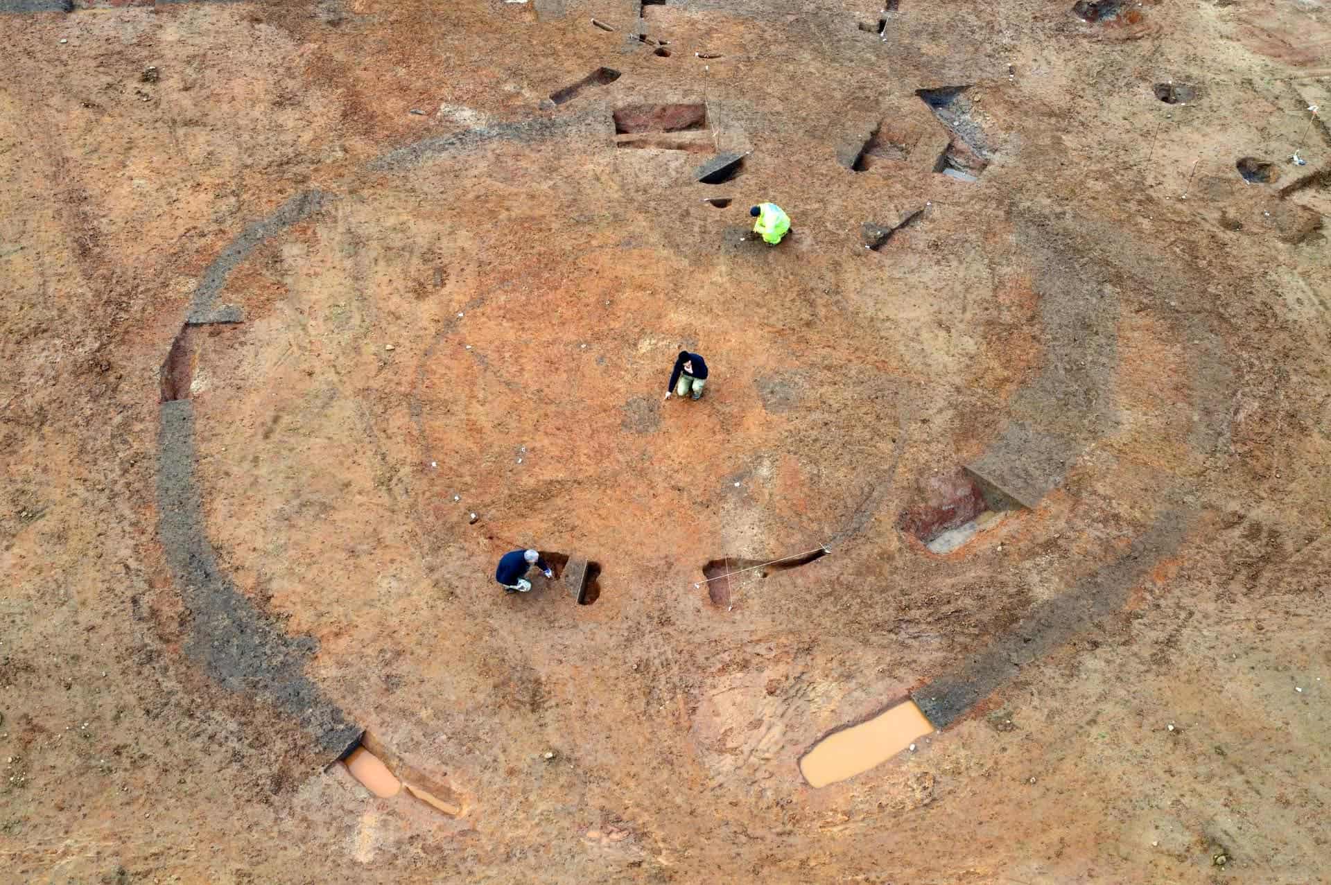
University of Leicester archaeologists have recovered a collection of rare Iron Age metal artifacts from a site in Glenfield Park, Leicestershire, England. Among the objects are decorated cauldrons, a complete sword, and a brooch from the 3rd century BC.
Aerial shot of the Glenfield Park roundhouse. Image credits: University of Leicester Archaeological Services.
The collection includes eleven cauldrons, several fine-crafted ring-headed dress pins, an involuted brooch and a cast copper-alloy ‘horn-cap’, likely a part of a ceremonial staff, archaeologists say. The objects were inhumed at the site in a series of events that took part over a considerable span of time, they add, resulting in multiple episodes of sediment deposition across the settlement.
“Glenfield Park is an exceptional archaeological site, with a fantastic array of finds that highlight this as one of the more important discoveries of recent years,” said Dr. John Thomas, director of the excavation and project officer from the University of Leicester Archaeological Services.
Dr. Thomas explains that human occupation in the area during the middle Iron Age (5th to 4th centuries BC) was “modest”, consisting of a small settlement with no walls on the south-facing slopes of the spur. Some time later, around the 4th to 3rd centuries BC according to current radiocarbon dating results, the site underwent major changes. Individual roadhouses were enclosed, “there was far more evidence for material culture”, and the inhabitants adopted rituals and rites that seem to involve “deliberate burial of a striking assemblage of metalwork.”
That metalwork is what truly sets the site apart, Dr. Thomas says. Not only is it found in much larger quantities than in other known comparable sites in the area, the items are also of much higher quality and the composition of the artifacts is also unique.
“The cauldron assemblage in particular makes this a nationally important discovery,” Dr. Thomas said. “They represent the most northerly discovery of such objects on mainland Britain and the only find of this type of cauldron in the East Midlands.”
The team reports that the cauldrons appear to have been placed in a large circular enclosure ditch that surrounded a building. It’s not known why yet, but it’s very likely that this was a deliberate choice, not an accident, the archaeologists add. The cauldrons had been placed either upright or inverted, after which the ditch was filled in. One hypothesis is that this burial was meant to mark an end to the activities carried out at this part of the site. Other cauldrons were found buried across the site, suggesting that these rituals were used to mark significant events over a long period of time as the settlement developed.
They are fashioned from several distinct parts — iron for the rims, upper bands, and the ring handles attached to them, copper alloy for the body. Size-wise, they range between 14.2 and 22 inches (36-56 cm) in diameter, with the summed-up capacity of all cauldrons around 550 liters. This volume is quite significant, and the team suspects that they may have been used to provide food for large groups of people, for example at gatherings held in the site for the area’s wider Iron Age community.
CT scans performed on the cauldrons show evidence of wear, tea, and repair, pointing to long-term and repeated use of the objects. The amount of care and effort that went into repairing them further reinforces the hypothesis that the cauldrons were special for the Iron Age community at Glenfield Park.
“Due to their large capacity it is thought that Iron Age cauldrons were reserved for special occasions and would have been important social objects, forming the centerpiece of major feasts, perhaps in association with large gatherings and events,” Dr. Thomas said.
“They are rarely found in large numbers and, with the exception of a }in Chiseldon, where 17 cauldrons were found in a pit, there have been few excavated examples in recent years.”
Dr. Thomas adds that cauldrons held a symbolic value in the area at the time, as evidenced by their frequent appearance in early-medieval Irish and Welsh literature.
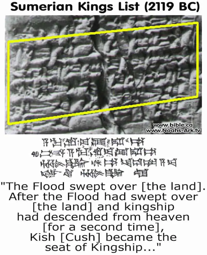
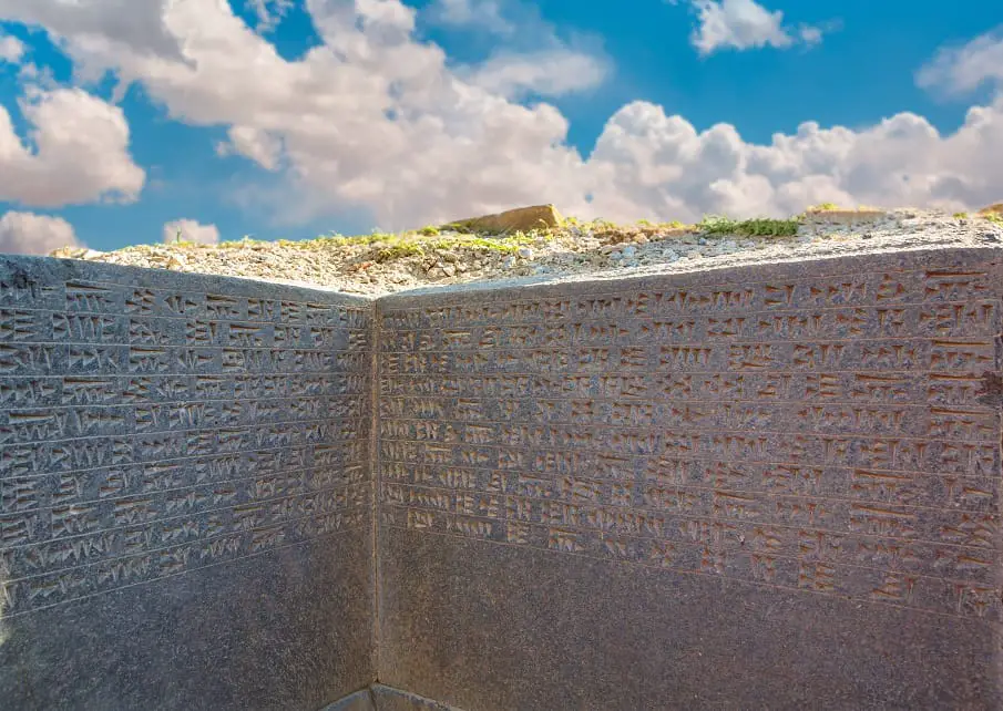
Before the Great Deluge, Eighth Antediluvian Kings ruled for 241,200 years
Before the Great Deluge, Eighth Antediluvian Kings ruled for 241,200 years
“After the kingship descended from heaven, the kingship was in Eridug. In Eridug, Alulim became king; he ruled for 28800 years.”
According to the accounts written down on the Sumerian King List, Eight ancient kings ruled over ancient Mesopotamia for a period of 241,200 years, before the Great Flood.
Despite the fact that the Sumerian King list names all rules who reigned over the lands of ancient Mesopotamia. Curiously, some of them are recorded having implausibly lengthy reigns.
Those are the first 8 rulers who according to the list, ruled for 241,200 years.
According to experts, none of the predynastic antediluvian rulers have so far been verified as historically accurate leaders by archaeological excavations, epigraphical inscriptions or otherwise.
The reign of antediluvian rulers was measured in sars, periods of 3600 years, ners, units of 600, and sosses units of 60.
The Sumerian King List states:
“After the kingship descended from heaven, the kingship was in Eridug. In Eridug, Alulim became king; he ruled for 28800 years.”
Alulim—28,800 years.
The first king to rule was Alulim, who ruled for 8 Sars, meaning a total of 28,800 years. He was the First ruler of Eridu, and the first king of Sumer. It is believed that Enki, the creator God and patron God od Eridu brought civilization to Sumer at this point.
Alalngar—36,000 years.
Alalngar was the second king of Eridu, and the predecessor of Alulim. The Sumerian King list states that he ruled for 36,000 years after which he was succeeded by En-men-lu-ana of Bad-tibira.
“Then Eridug fell and the kingship was taken to Bad-tibira.”
En-men-lu-ana—43,200 years
The next ruler who was king after Eridug fell was En-men-lu-ana who ruled for 43,200 years. According to the Sumerian King List, En-men-lu-ana was the third pre-dynastic ruler of ancient Sumer, and was the ‘longest reigning king’ according to historical accounts written down on the Sumerian King List.
En-men-gal-ana—28,800 years.
According to the Sumerian King List the fourth pre-dynastic ruler of Ancient Sumer was En-men-gal-ana who ruled for 28,800 years. He was succeeded by Dumuzid, the Shepherd.
Dumuzid, the Shepherd—36,000 years.
Dumuzid, commonly referred to as the ‘Shephard’ was the fifth pre-dynastic ruler that, according to the ancient Sumerian King List ruled of Sumer before the Deluge. According to historical accounts, he ruled for 36,000 years. Dumuzid is mentioned sometimes as the Son of Enki.
“Then Bad-tibira fell and the kingship was taken to Larag.”
After the fall of Bad-tibira, the Sumerian King List indicates En-sipad-zid-ana as the next ruler.
En-sipad-zid-ana—28,800 years.
En-sipad-zid-ana is mentioned as the sixth pre-dynastic ruler of ancient Sumer before the Deluge. According to the Sumerian King List, he ruled for 28,800 years.
“Then Larag fell and the kingship was taken to Zimbir.”
En-men-dur-ana—21,000 years.
The following ruler mentioned in the Sumerian King List after the fall of Larag is En-men-dur-ana, who was the seventh pre-dynastic king of Sumer and ruled for a total of 21,000 years.
“Then Zimbir fell and the kingship was taken to Shuruppag.”
After the fall of Zimbir, Ubara-Tutu ruled over ancient Sumer for a period of 18,600 years. Ubara-Tutu was the eighth and final pre-dynastic ruler of ancient Sumer, as noted in the Sumerian King List. Ubara-tutu is believed to have live until the great deluge swept over the land.
Eridu, the first city on Earth before the great flood, according to the Sumerian King List
Eridu, the first city on Earth before the great flood, according to the Sumerian King List
According to the Sumerian King List Eridu was the first city in the World. The opening line reads:
“[nam]-lugal an-ta èd-dè-a-ba
[eri]duki nam-lugal-la”
“When kingship from heaven was lowered,
the kingship was in Eridu.”
Eridu (Coordinates: 30 ° 48’57.02 “N 45 ° 59’45.85” E) was an ancient city in southern Mesopotamia, 24 kilometers south of Ur in the current archaeological site of Tell Abu Shahrein. Eridu, also transliterated as Eridug, could mean “mighty place” or “guidance place” according to scholars who say this archaeological site is of great importance.
At its foundation, it was most likely within walking distance of the Persian Gulf; however, currently, due to the accumulation of silt at the shoreline over the millennia remains of Eridu are now some distance from the gulf at Abu Shahrain in Iraq.
Some scholars argue that in ancient Sumerian times Eridu was linked to the estuary by means of channels and according to the Babylonian epics, it was the first city created in the world.
As noted by Sumerian mythology, the ancient city of Eridu was ONE of the FIVE ancient cities built on Earth before the great deluge.
Eridu was the most southern city of the conglomerate of Mesopotamia and important center of the cult to the God of the water, Enki.
In July 2016, UNESCO chose the archaeological site of tell Eridu as a Mixed Heritage of Humanity, as “part of the archaeological remains of Sumerian settlements in Lower Mesopotamia, which flourished between the third and fourth millennia BC in the delta formed by the Euphrates and Tigris rivers.”
As noted by ancient Sumerian tradition, as well as the Sumerian King list, Eridu was the oldest of the cities of Mesopotamia, in whose location the god Marduk had created the world.
Archaeologists have proven, through research in the twentieth century, that the lower levels of the city (level XIX) date back to at least 4900 B.C., at the beginning of the El Obeid period. Mainstream scholars suggest the city was founded in the 54th century BC.
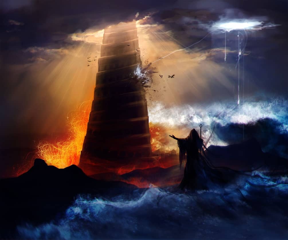
Egyptologist David Rohl has conjectured that Eridu, may have been the original Babel and site of the mythical Tower of Babel, rather than the later city of Babylon.
Image Credit: Shutterstock.
In this first stage, the ceramic remains show a significant role of Eridu in the region.
Towards 3800 BC (level VI) the city had an important temple and a cemetery from which a thousand graves have been discovered.
Towards the year 2500 BC., during the archaic dynastic, a ruler, perhaps of the first dynasty of Ur, built a great palace in Eridu, and at the end of the III millennium BC, during the reign of Amar-Sin, a large ziggurat was built in the city, which remained an important religious center in the empire of the third dynasty of Ur.
According to the Sumerian King list, the first ‘mythological’ kings, successors of the reign of heaven, are those of Eridu.
The king list continues:
In Eridu, Alulim became king; he ruled for 28800 years. Alalngar ruled for 36000 years. 2 kings; they ruled for 64800 years. Then Eridu fell and the kingship was taken to Bad-tibira.
The Sumerian King list describes in unprecedented detail a time when the world was governed by beings referred to as ‘Gods’ for thousands of years. This is one of the main reasons why mainstream scholars suggest that the Sumerian King list is a mixture of prehistorical and mythological accounts and that those rulers who lived through implausibly lengthy reigns were not real, and were part of ancient folklore.
Mainstream scholars see the age a ruler allegedly governed over the people as a reflection of his or her importance. The more years a king ruled, the more important he was. However, this is highly debated among many authors.
This ancient city was one of the most important settlements in ancient times, and the urban nucleus of Eridu was Enki’s temple, called House of the Aquifer.
After the kingship descended from heaven, the kingship was in Eridu.
Sumerian Kings List - Antediluvian Kings
Sumerian Tablets Reveal The Secrets Of Noahs Ark - Documentary
The Sherbrooke stones: Evidence of Africans visiting America 2,500 years ago?
The Sherbrooke stones: Evidence of Africans visiting America 2,500 years ago?
Located in the Museum of the Seminary of Sherbrooke are a set of mysterious stones that, according to many who have researched them, could offer conclusive evidence that neither the Vikings, nor Columbus traveled to America first, but a culture from Northern Africa, and 2,500 years ago.
The stones inscriptions allegedly tell the story of northern African explorers who traveled to the American continent some 2,500 years ago.
The stones, which are located at the museum since 1910 are believed to have been discovered in the early 19th century. One of the stones was found 100 miles east of Montreal, in a field near Bromptonville, five miles north of Sherbrooke, while the other one was discovered on a hill overlooking Sherbrooke.
So, did African explorers reach the American continent thousands of years ago?
According to the inscriptions of the two stones made of limestone, the answer is a profound yes.
The two stones are approximately 22 by 32 inches.
The man who supposedly delivered the inscriptions on the stones was Professor Thomas Lee, an archaeologist from the University of Laval.
According to a newspaper slip, Professor Lee argues the inscriptions on the stones were written in an ancient Libyan script.
“The Libyans would have been operating, in my opinion, out of Carthage, which was a Phoenician city at the time,” Professor Lee is quoted in the newspaper.
According to Professor Lee, the ancient African expedition most likely reached the area after successfully sailing up the Sint. Francis River.
The inscriptions written in stone were deciphered by Howard Barraclough Fell, a professor of invertebrate zoology at the Harvard Museum of Comparative Zoology.
Despite the fact that Fell’s primary professional research included starfish and sea urchins, he is best known for his controversial work in New World epigraphy, arguing that various inscriptions in the Americas are best explained by extensive pre-Columbian contact with Old World civilizations.
Professor Fell’s work was—unsurprisingly—rejected by most mainstream scholars who firmly reject the notion that African explorers arrived in the American continent around 2,500 years ago.
According to Fell’s translation of the stones, they read: “Expedition that crossed in the service of Lord Hiram to conquer territory.” While the other of the pair discovered together bears the inscription: “Record by Hata, who attained this limit on the river, moored his ship and engraved this rock.”
Researchers argue that the text carved on the stone is called Boustrophedon, in which “you read the first line left to right and the next line right to left.”
Professor Fell is quoted saying that “barabarous lands at the end of the world” is probably a description of the Americas. Fell argues that the people who left the stones behind most likely made two more expeditions, one towards the Yucatan Peninsula. Professor Fell is quoted in the newspaper saying: One stone found there “gives the area its name”.
Evidence of trans-oceanic voyages?
Interestingly, there are many ‘controversial’ pieces of evidence that suggest ancient cultures from America and Africa were interconnected, thousands of years ago.
For example, it is well known that a researcher called Dr. Svetla Balabanova discovered traces of Coca and Tobacco in ancient Egyptian mummies. Curiously, there is no evidence of coca or tobacco cultivation in Africa, Europe or Asia before the time of Christopher Columbus.
The Fawn Hood Mummy
Another curious discovery was made some 200 years ago when miners discovered a strange mummy in one of the largest cave systems in America: The Mammoth Cave. Inside it, miners found an extremely well-preserved mummy with red hair prepared and embalmed in an eerily similar way as the ancient Egyptians. After examining the mummy in the late 1800’s, the Smithsonian Institute ‘lost’ the mummy.
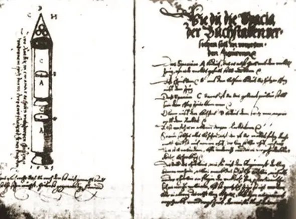
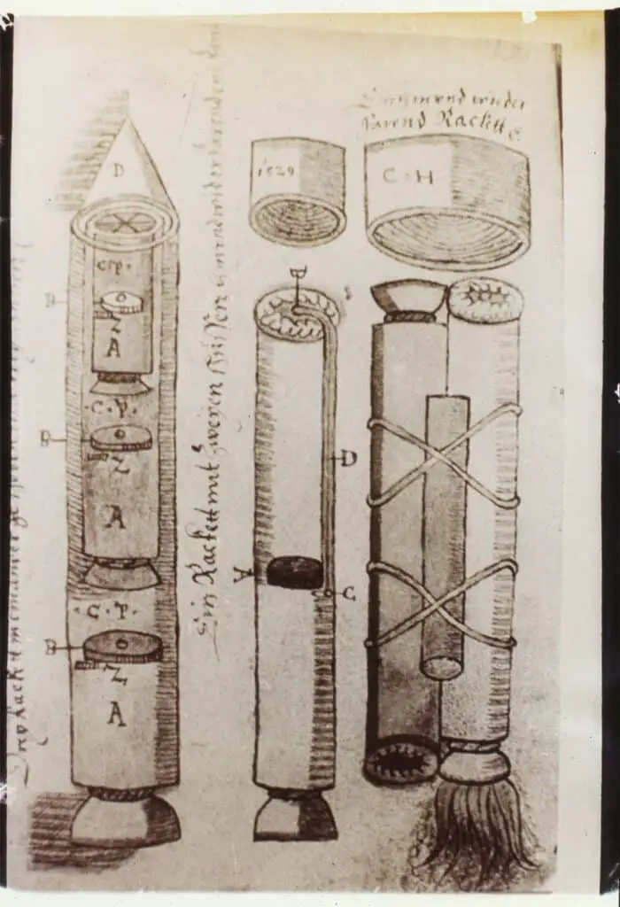
The Sibiu Manuscript—a 500-year-old text that describes multi-stage rockets
The Sibiu Manuscript—a 500-year-old text that describes multi-stage rockets
The Sibiu manuscript discovered in 1961, is a collection of around 450 pages that include among many other things, three-stage rockets and manned rocket flight.
Most of us are unaware of the fact that there are countless ancient manuscripts scattered across the globe, describing what many consider as improbable achievements of the past.
What would you say If I told you that there is an ancient manuscript that dates back nearly 500 years, and describes liquid fuel, multi-stage rockets, and even manned rockets?
You’d either say I’m crazy, or it’s just fake news.
*Have you noticed how people these days call out as fake news anything that they find hard to believe or goes against their belief system?
Anyway, the Sibiu manuscript is real, it’s not fake news, and it does, in fact, describe—among other things— liquid fuel and multi-stage rockets, and it was officially published in the 16th century, although many believe it was written using texts that go back further in time.
The Sibiu Manuscript was found in 1961 by Doru Todericiu, a professor of Science and Technology at the University of Bucharest. The manuscript contained around 450 pages which were recovered from the archives of the city of Sibiu, in Romania.
To the surprise of Todericiu, the ancient text was flooded with drawings and technical data on artillery, ballistics and detailed descriptions of multistage rockets.
Referred to as the Sibiu manuscript ever since, the ancient text is believed to have been written by a man called Conrad Haas, between 1550 and 1570.
Conrad Haas is believed to have been a military engineer who worked for the Kingdom of Hungary and the Principality of Transylvania.
The ancient manuscript origins aren’t very clear, nor are the origins of its author who according to historians is believed to have been born in either Austrian or Transylvania and became the head of the arsenal of the Austrian Empire under King Ferdinand I.
Description of a rocket by Conrad Haas.
Image Credit: Wikimedia Commons
The Sibiu manuscript, written entirely in German, was found to be a theoretical treatise on the construction of different types of weapons, including—for the first time in history—multistage rocket technology. It also includes details on the combination of fireworks with weapons, the design of fins in the shape of a hang glider as well as the creation of fuel mixtures with the use of liquid fuel.
It remains a mystery whether or not Haas managed to use his designs and put into practice, but there are some who claim that a rocket launch was carried out in Sibiu in 1550, but there is no documentary evidence to support these claims.
We do know from history that Johann Schmidlap, a 16th-century Bavarian fireworks maker, and rocket pioneer, was the first to experiment with two-stage and three-stage rockets around 1590.
Before the discovery of the Sibiu manuscript, the earliest details of a three-stage rocket was attributed to Kazimierz Siemienowicz, a Polish specialist in artillery, who published details about rocketry in his 1650 treatise Artis Magnae Artilleriae Pars Prima.
Conrad Haas wrote down a few interesting sentences in his manuscript in which he talks about the military use of rockets (translated):
“But my advice is for more peace and no war, leaving the rifles calmly in storage, so the bullet is not fired, the gunpowder is not burned or wet, so the prince keeps his money, the arsenal master his life; that is the advice Conrad Haas gives.”
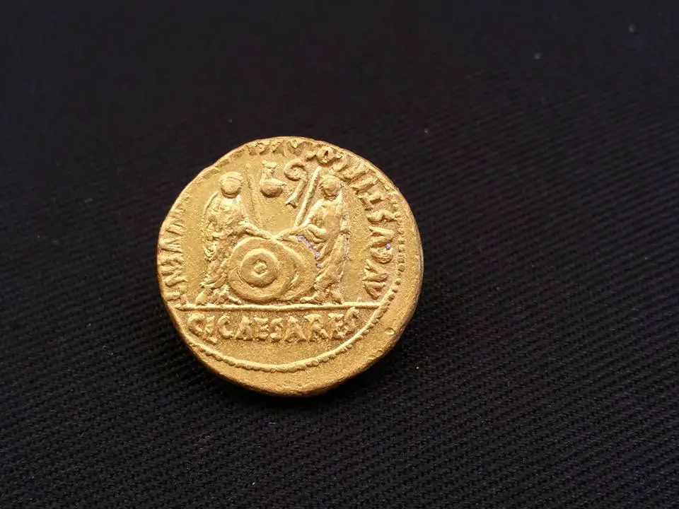
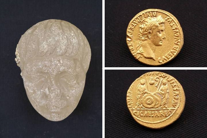
Archaeologists make stunning underwater discovery near the port of Alexandria in Egypt
Archaeologists make stunning underwater discovery near the port of Alexandria in Egypt
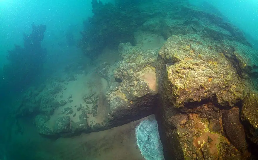
Three shipwrecks dating back to ancient Roman times have been discovered by experts during archaeological excavation work carried out in the eastern port of Alexandria, Egypt. It is believed that more shipwrecks will be found as excavations continue in 2018.
Ancient Egypt’s gateway to the Mediterranean – submerged and buried under layers of sand – is an important reminder of the great numbers of sunken treasures that remain hidden from modern history.
Now, experts have made another sensational discovery in the bay of Abu Qir in Alexandria.
Three ancient shipwrecks dating back to Roman times have been discovered during archaeological excavation work carried out in the eastern port of Alexandria, Egypt.
The discovery, made by an Egyptian mission in collaboration with the European Institute of Underwater Archeology, includes a head carved in glass dating from Roman times and probably belongs to the commander of the Roman armies «Antonio», in addition to three golden coins dating from the Emperor “Octavio”, in the bay of Abu Qir in Alexandria.
Mostafa Waziri, the head of the Supreme Council of Antiquities, confirmed the find in a statement posted on the Egyptian Ministry of Antiquities Facebook page.
One of the artifacts recovered from the shipwrecks.
Image Credit: Egyptian Ministry of Antiquities.
The archaeological mission has also discovered a votive boat of the god Osiris in the sunken city of Heraklion.
According to Egypt’s Ministry of Antiquities, Osama Alnahas, head of the Central Department of Underwater Antiquities in Egypt, the discovery of the three shipwrecks may point the archaeological mission to other treasures still hidden underwater.
Excavation work indicates that a fourth wreck would be discovered during the next season, as the mission discovered several large wooden planks, as well as archaeological remains of ceramic vessels that may represent the cargo of the ship.
The discovery of the three shipwrecks was made after archeologists dived down to the sunken city of Heraclion, located underneath Abu Qir Bay.
The underwater city of Heraclion is one of the sunken jewels of Ancient Egypt.
Heraclion was an ancient Egyptian city located near the Canopic Mouth of the Nile, about 32 km northeast of Alexandria.
Its ruins are located in Abu Qir Bay, currently 2.5 km off the coast, under 10 m (30 ft) of water.
Experts believe more treasure remains hidden underwater.
Image Credit: Egyptian Ministry of Antiquities.
Its legendary beginnings go back to as early as the 12th century BC, and it is mentioned by ancient Greek historians.
Its importance grew particularly during the waning days of the Pharaohs.
In the Late Period, it was Egypt’s main port for international trade and collection of taxes.
The submerged ruins of the city were located by French underwater archaeologist Franck Goddio in 1999.
Until then, scholars were not sure if Heraclion and Thonis were in fact one and the same city. Goddio’s finds have included incomplete statues of the god Serapis and the queen Arsinoe II.
Experts believe that a treasure-trove of ancient artifacts still remain to be found in the Abu Qir Bay, where the three ancient Roman shipwrecks were just found.
Researchers find a 3,000-year-old ‘Castle’ in the largest lake in Turkey
Researchers find a 3,000-year-old ‘Castle’ in the largest lake in Turkey
The locals have been telling stories for centuries that there is “something” hidden in the depths of Lake Van, in Turkey. In fact, the place even has its own legendary monster.
Now, a team of archaeologists has just discovered that legends can have their basis after all and that not all legends are just folklore and myth.
Divers from Van Yüzüncü Yıl University have just found something, indeed, but it is not a monster, but the ruins of a huge castle built sometime between the ninth and sixth centuries BC.
The ruins stretch for one kilometer to a depth of several hundred meters. The alkalinity of the water has served to preserve the walls in enviable conditions, with sections that rise up to four meters high at the bottom of the lake. However, it is not known for sure how tall they are. Part of the structure is buried in the mud and researchers believe it can be an even bigger construction.
The castle belongs to the mysterious civilization of the Urartu, also known as the Kingdom of Van. 3,000 years ago, the water level in Lake Van was much lower, and the Urartu settled here, building cities with palaces and temples inspired by Assyrian architecture and lavishly decorated details.
Ancient Urartu cuneiform from Cavustepe’s fortress.
Image Credit: Shutterstock
The remains of some of these buildings have been appearing over the years on the shores of the lake. Among them, researchers have found an ancient fortress with an inscription carved by order of King Darius, father of Xerxes the Great.
The discovery of the submerged castle confirms that the region was of great importance in its day.
Perhaps it is even one of the lost capitals of the Urartu empire.
The Urartu empire stretched across a region between the southeast of the Black Sea and the southwest of the Caspian Sea, currently shared by the Armenian Republic, Iran, and Turkey, formed after the fall of the Hittite Empire.
It includes the great lakes Van in Turkey (where the old capital Tushpa is located), Urmia (in Iran) and Lake Seván (in Armenia).
Urartu is one of the first kingdoms of Armenia.
The underwater ruins.
Its ancient historical apogee took place in the IX and VIII centuries BC.
The local language was similar to Hurrian.
The proximity to the overwhelming Assyrian kingdom produced from 1275 BC a strong ideological, literary and technical influence on Urartu.
Speaking to Hurriyet Daily News, Mr. Tahsin Ceylan, an underwater photographer and videographer said:
“Many civilizations and people had settled around Lake Van. They named the lake the ‘upper sea’ and believed it had many mysterious things. With this belief in mind, we are working to reveal the lake’s ‘secrets,’” adding that Lake Van had a history of 600,000 years.
“The walls of this castle cover a wide section. The excavations need to be done underwater but we don’t know how deep the walls are. A three to four meter wall section can be seen and the castle ruins cover an area of one kilometer. Since the water of Lake Van is alkaline, the castle has not been damaged and has kept its characteristics underwater. We have detected the castle’s exact location and photographed it and have made progress in our research. We now believe we have discovered a new area for archaeologists and historians to study,” Ceylan said.
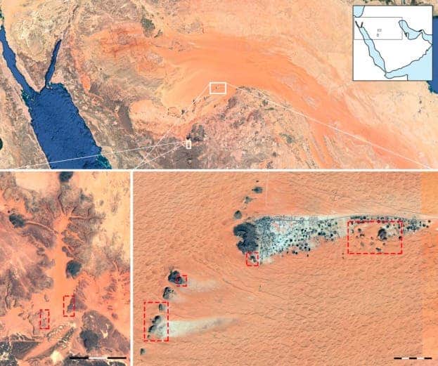
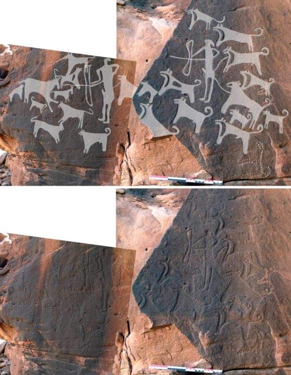
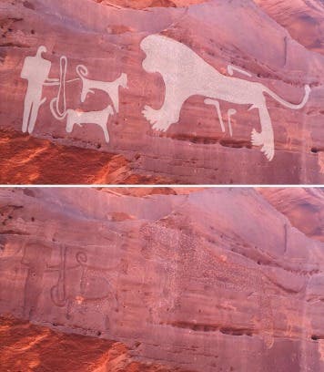
Two ancient sites in Saudi Arabia have revealed an unexpected surprise, a new paper reports — the oldest known recording of dogs put on a leash. The 8,000-year-old images are etched into rock and depict humans and dogs working together in hunts before the widespread emergence of agriculture.
The carvings were discovered by Maria Guagnin, an archaeologist at the Max Planck Institute for the Science of Human History, at two rock-art sites in northwestern Saudi Arabia, Shuwaymis and Jubbah. The images, estimated to be around 8,000 years old, depict humans and dogshunting side by side, and suggest that the two species were already ‘friends’ beforefarmingtook hold.
The locations of Shuwaymis (bottom left) and Jubbah (bottom right). Image credits Guagnin, M. et al., 2017, Journal of Anthropological Archaeology.
The two sites “contain the best and oldest examples of Neolithic rock art,” Saudi-Archaeology claims, adding that the region used to be rich “with people, flora, and wildlife” in the past. Those people left behind thousands of panels of rock-art showcasing their lives, society, and hunts, which Guagnin was documenting when she stumbled upon the unusual scenes.
Overall, she counted 156 depictions of dogs at Shuwaymis and 193 at Jubbah. The animals resemble today’s Canaan breed in appearance, Guagnin adds, with pricked ears, curled tails, and short snouts. They’re most often depicted helping bow-wielding human hunters take down prey including lions, ibexes, gazelles, or horses. The animals are clearly distinct from the hyenas and wolves depicted in other panels, Guagnin and her co-authors write.
Image credits Guagnin, M. et al., 2017, Journal of Anthropological Archaeology.
Comparison between the Canaan breed and the dogs on the rock art panels.
Image credits Guagnin, M. et al., 2017, Journal of Anthropological Archaeology.
From what we know so far, dogs were domesticated from an ancestor of today’s gray wolf between 40,000 and 15,000 years ago. There’s still a lot of unknowns (and thus, room for debate) about how and where this domestication process took place, and how early humans and dogs interacted and co-existed. The panels described by Guagnin’s team will help to guide these discussions in the future. The images haven’t been directly dated so far, but the team estimates they date back between 8,000 and 9,000 years ago, to the pre-Neolothic era, before farming took root in the region.
The most interesting find, however, was that some of the hunting dogs taking seem to be leashed. The art depicts these dogs as tethered to the waist of hunters, quite the smart hack when you need two free hands to shoot arrows. It hasn’t been established why these dogs were leashed, but the team speculates that they may have been young dogs still undergoing training, old ones that could be injured in the thick of the hunt, or scent dogs that were too valuable to risk.
Image credits Guagnin, M. et al., 2017, Journal of Anthropological Archaeology.
“This suggests not only are some human populations controlling their hunting dogs by the Pre-Neolithic, but that some dogs may perform different hunting tasks than others,” the paper explains.
“Some may be used only to track prey scents, while others are used to corral and attack prey, protect human hunters, or help haul meat back to camp.”
The hunting scenes represent the earliest known evidence of dog leashes in the archaeological record worldwide, the study claims. Furthermore, they push back the presence of domesticated dogs on the Arabian Peninsula to much earlier than we’d believed. Previously, the oldest dog remains found on the whole peninsula hailed from the 4th millennium B.C. in today’s Yemen, some 2-3 thousand years younger that the estimated age of the Shuwaymis and Jubbah panels.
The paper, “Pre-Neolithic evidence for dog-assisted hunting strategies in Arabia” has been published in the Journal of Anthropological Archaeology.
Thousands of feet below the crashing surface of the North Pacific ocean, there’s a dark place where the water stands still. Scientists call it the Shadow Zone, and they’re not just being dramatic. In a recent Nature article, an Australian team of researchers point out that this lightless region of the abyssal ocean has trapped the same water for 2,000 years.
The reason, they report in their paper, can be found even deeper in the sea.
For a long time, scientists had been aware of the existence of the ancient water, but it was never clear why and how it managed to stay still for so long while the ocean above it rolls around so violently.
“Carbon-14 dating had already told us the most ancient water lies in the deep North Pacific,” said lead author and University of New South Wales oceanographer, Casimir de Lavergne, Ph.D., in a statement. “But until now we had struggled to understand why the very oldest waters huddle around the depth of 2 km.”
NASA's snapshot of ocean currents suggests water is always moving, but things are different below the surface.
They realize now, after an analysis of the ocean topography in that area, that the Shadow Zone’s specific depth and location are determined by the slopes and crags of the sea floor below it. According to the scientists, the Shadow Zone is a roughly rectangular patch of especially deep ocean stretching 3,700 miles from east to west and 1,200 miles north to south — making its surface area slightly larger than Europe’s — and the floor beneath it is especially rough.
This uneven floor, coupled with the way that shallower wind-driven currents running above the Shadow Zone move, has sandwiched the ancient water in its stratified position for at least 1,500 years, the researchers write. The shape of the floor prevents water at the very bottom of the sea from rising any further than 1.5 miles below the surface, effectively creating another watery floor. All the water above that layer is largely undisturbed — it’s far enough from the geothermal heat vents that promote mixing — leading to the eerily still Shadow Zone.
The water above and below the Shadow Zone moves laterally -- just not vertically.
It isn’t just water that’s in the Shadow Zone, the researchers point out, noting that the trapped molecules could have major effects on the ocean and even global climate when it eventually does escape.
“When this isolated shadow zone traps millennia old ocean water it also traps nutrients and carbon which have a direct impact on the capacity of the ocean to modify climate over centennial time scales,” read a statement from Stockholm University co-author Fabien Roquet, Ph.D.
If you liked this article, check out this video about underwater drones for exploring ocean life.
Newly-found fossils reveal Antarctica had lush forests before Dinosaurs existed
Newly-found fossils reveal Antarctica had lush forests before Dinosaurs existed
Antarctica—the ‘inhospitable’ white Continent that we know today, was once a surface covered with leafy subtropical forests full of palm trees, ferns, and conifers.
Just over 50 million years ago, the frozen continent looked very different from what we see today.
If mankind could travel to the past and visit Antarctica, we wouldn’t need to wear thermal and waterproof clothing as current expeditions do since the temperatures would be warm and pleasant.
Now, a group of researchers has discovered more evidence of what Antarctica looked like in the distant past as they have found fossil fragments from 13 trees that grew at the end of the Permian Period, before Dinosaurs.
The discovery was made by Erik Gulbranson and John Isbell from the University of Wisconsin-Milwaukee (UWM) who were exploring the continents’ Transantarctic Mountains. By the end of their journey, the scientists discovered fossilized parts of 13 trees.
The discovery confirms one more time that the now-frozen continent was once covered in lush forests and teeming with life, most likely when it was still part of the supercontinent Gondwana that spanned the whole of the Southern Hemisphere.
Erik Gulbranson, paleoecologist and visiting assistant professor at UWM, examines some of the fossilized polar trees he recovered from Antarctica.
Image Credit:Troye Fox, UWM Photo Services
Scientists are convinced that massive forests covered the entire continents at the end of the Permian Period, the geological era before first dinosaurs.
“People have known about the fossils in Antarctica since the 1910-12 Robert Falcon Scott expedition. Nevertheless, most of Antarctica is still unexplored today. Sometimes, you might be the first person to ever climb a certain mountain,” Gulbranson said.
The so-called Permian Period came to an end some 251 million years ago in what is considered history’s greatest mass extinction, as our planet rapidly shifted from icehouse to greenhouse conditions.
It is believed that than 90 percent of species on Earth disappeared, including the polar forests scientists found evidence of.
A 280-million-year-old tree stump still attached to its roots in Antarctica.
Image Credit: Erik Gulbranson
Since the lush Antarctic tree grew at polar latitudes were plants cannot grow today, researchers believe the trees that once grew there were an extremely species. Experts are now trying to understand why the forests went extinct.
“This ancient forest is a glimpse of life before the extinction, and this can help us understand what caused the event,” explained Gulbranson.
Scientists explain that the frosts that once grew on the Antarctic continent were used to conditions unlike anywhere else on the planet, having to survive through polar extremes of endless light, and total darkness, which, according to experts, is another reason why its worth studying why they went extinct.
“There isn’t anything like that today. These trees could turn their growing cycles on and off like a light switch. We know the winter shutoff happened right away, but we don’t know how active they were during the summertime and whether they could force themselves into dormancy while it was still light out,” Gulbranson said.
HERCACLEION LOST CITY UNDERWATER FOUND AFTER 1200 YEARS
HERCACLEION LOST CITY UNDERWATER FOUND AFTER 1200 YEARS
Abu Qir is located in the northeast of Alexandria, where archaeologists explore the two ancient cities of Heraklion and Canopus since 1992.
In addition to being a prominent religious center, Heraklion was a major trading point on the Mediterranean Sea in the 6th century. When archeologists began to dive into this site, they discovered the ruins of the Temple of Heraklion, which was dedicated to Amun and Harqal-Khonsu. They also found huge statues of the gods, Ptolemaic kings, their wives, their nests and jewels, and numerous broken wooden ships.
Beste bezoeker, Heb je zelf al ooit een vreemde waarneming gedaan, laat dit dan even weten via email aan Frederick Delaere opwww.ufomeldpunt.be. Deze onderzoekers behandelen jouw melding in volledige anonimiteit en met alle respect voor jouw privacy. Ze zijn kritisch, objectief maar open minded aangelegd en zullen jou steeds een verklaring geven voor jouw waarneming! DUS AARZEL NIET, ALS JE EEN ANTWOORD OP JOUW VRAGEN WENST, CONTACTEER FREDERICK. BIJ VOORBAAT DANK...
Druk op onderstaande knop om je bestand , jouw artikel naar mij te verzenden. INDIEN HET DE MOEITE WAARD IS, PLAATS IK HET OP DE BLOG ONDER DIVERSEN MET JOUW NAAM...
Druk op onderstaande knop om een berichtje achter te laten in mijn gastenboek
Alvast bedankt voor al jouw bezoekjes en jouw reacties. Nog een prettige dag verder!!!
Over mijzelf
Ik ben Pieter, en gebruik soms ook wel de schuilnaam Peter2011.
Ik ben een man en woon in Linter (België) en mijn beroep is Ik ben op rust..
Ik ben geboren op 18/10/1950 en ben nu dus 74 jaar jong.
Mijn hobby's zijn: Ufologie en andere esoterische onderwerpen.
Op deze blog vind je onder artikels, werk van mezelf. Mijn dank gaat ook naar André, Ingrid, Oliver, Paul, Vincent, Georges Filer en MUFON voor de bijdragen voor de verschillende categorieën...
Veel leesplezier en geef je mening over deze blog.


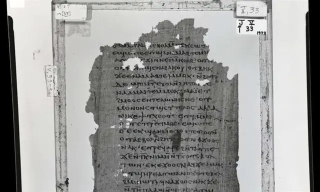

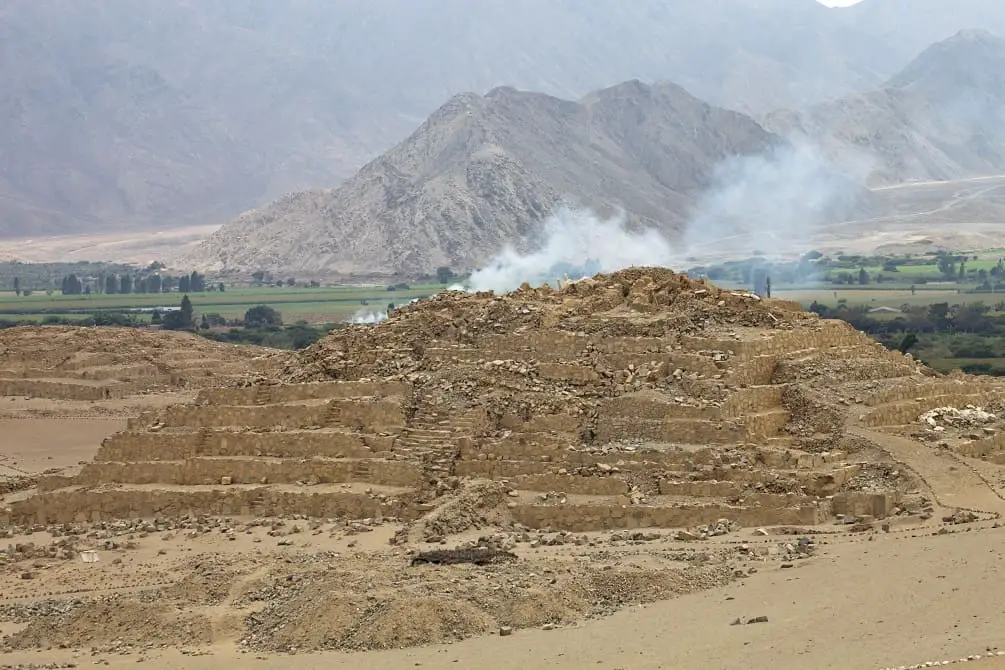
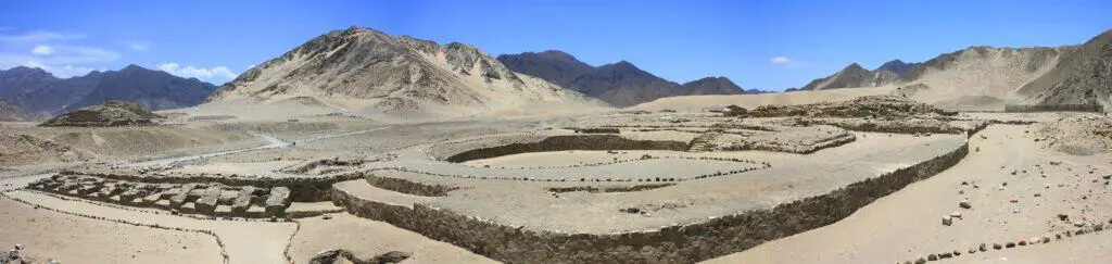
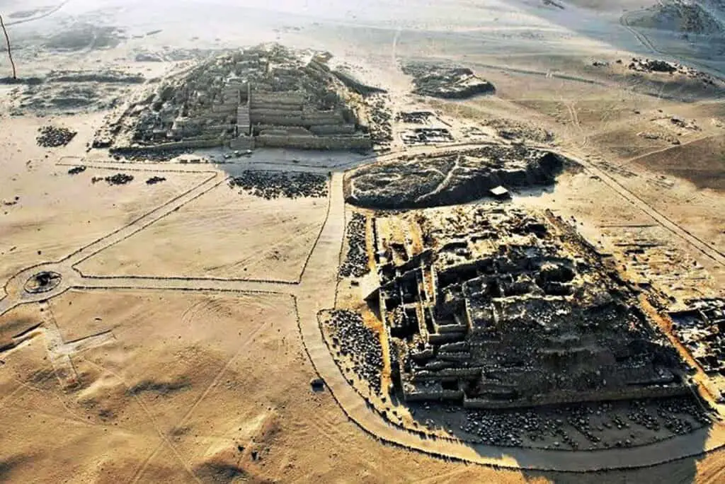
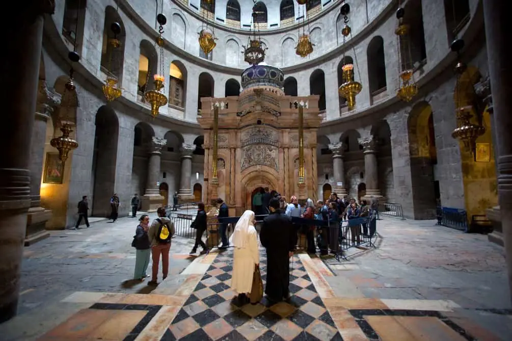
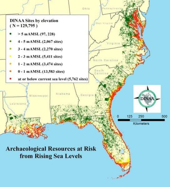


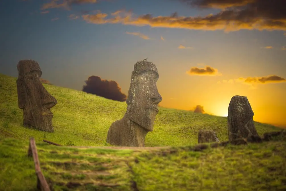
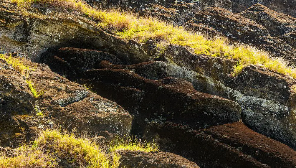
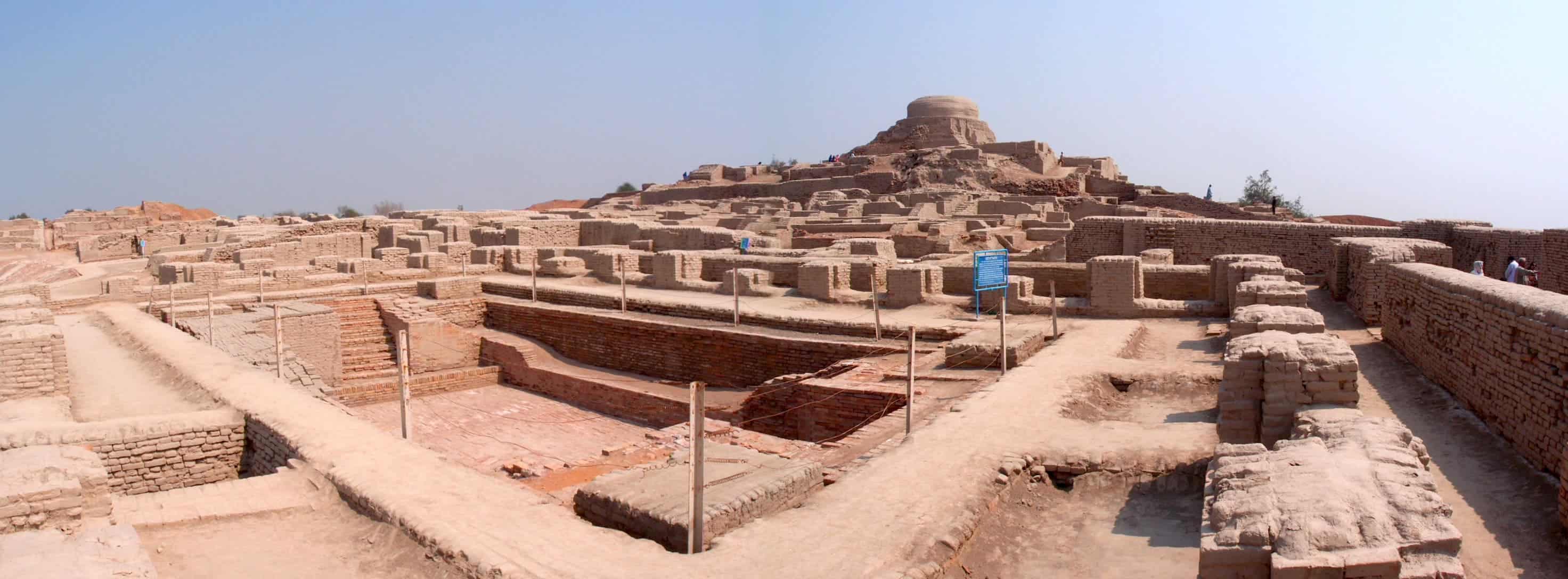

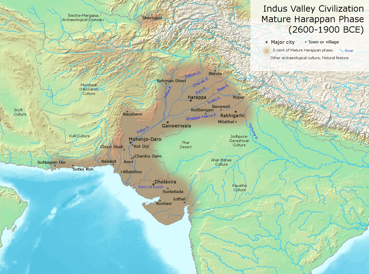
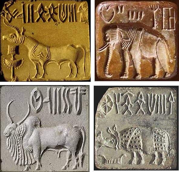
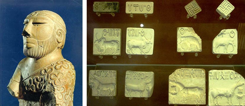
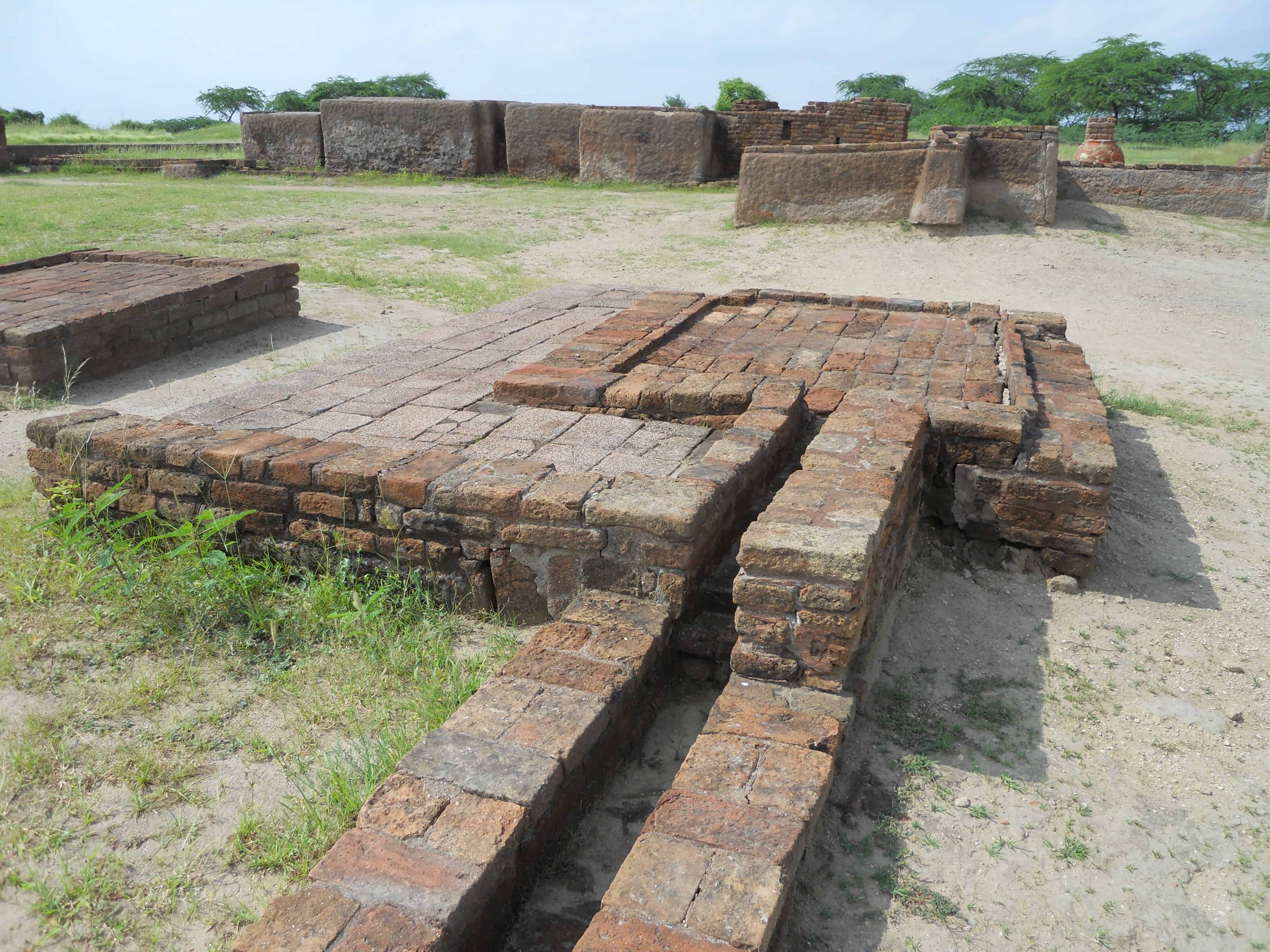
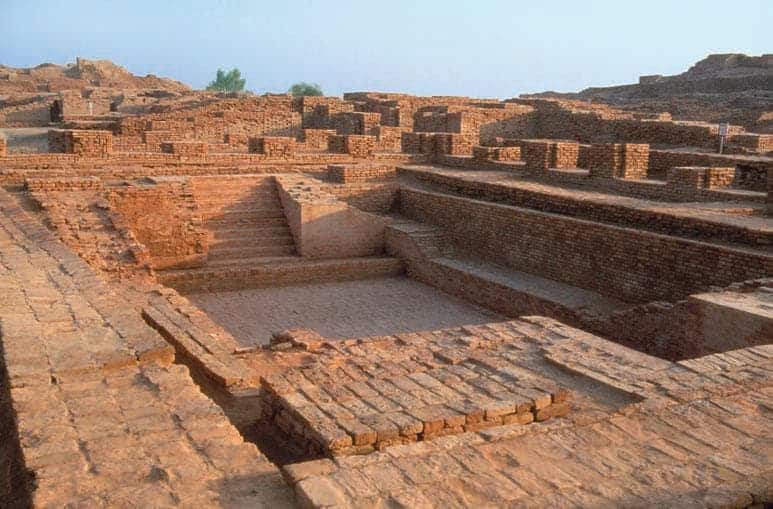


 Scientists Shock The World By Revealing These Ancient Hand Prints Were Not Left By Humans
 This Underground Complex Is A Million Years Old. Man-Made Or History