The purpose of this blog is the creation of an open, international, independent and free forum, where every UFO-researcher can publish the results of his/her research. The languagues, used for this blog, are Dutch, English and French.You can find the articles of a collegue by selecting his category. Each author stays resposable for the continue of his articles. As blogmaster I have the right to refuse an addition or an article, when it attacks other collegues or UFO-groupes.
Druk op onderstaande knop om te reageren in mijn forum
Zoeken in blog
Deze blog is opgedragen aan mijn overleden echtgenote Lucienne.
In 2012 verloor ze haar moedige strijd tegen kanker!
In 2011 startte ik deze blog, omdat ik niet mocht stoppen met mijn UFO-onderzoek.
BEDANKT!!!
Een interessant adres?
UFO'S of UAP'S, ASTRONOMIE, RUIMTEVAART, ARCHEOLOGIE, OUDHEIDKUNDE, SF-SNUFJES EN ANDERE ESOTERISCHE WETENSCHAPPEN - DE ALLERLAATSTE NIEUWTJES
UFO's of UAP'S in België en de rest van de wereld Ontdek de Fascinerende Wereld van UFO's en UAP's: Jouw Bron voor Onthullende Informatie!
Ben jij ook gefascineerd door het onbekende? Wil je meer weten over UFO's en UAP's, niet alleen in België, maar over de hele wereld? Dan ben je op de juiste plek!
België: Het Kloppend Hart van UFO-onderzoek
In België is BUFON (Belgisch UFO-Netwerk) dé autoriteit op het gebied van UFO-onderzoek. Voor betrouwbare en objectieve informatie over deze intrigerende fenomenen, bezoek je zeker onze Facebook-pagina en deze blog. Maar dat is nog niet alles! Ontdek ook het Belgisch UFO-meldpunt en Caelestia, twee organisaties die diepgaand onderzoek verrichten, al zijn ze soms kritisch of sceptisch.
Nederland: Een Schat aan Informatie
Voor onze Nederlandse buren is er de schitterende website www.ufowijzer.nl, beheerd door Paul Harmans. Deze site biedt een schat aan informatie en artikelen die je niet wilt missen!
Internationaal: MUFON - De Wereldwijde Autoriteit
Neem ook een kijkje bij MUFON (Mutual UFO Network Inc.), een gerenommeerde Amerikaanse UFO-vereniging met afdelingen in de VS en wereldwijd. MUFON is toegewijd aan de wetenschappelijke en analytische studie van het UFO-fenomeen, en hun maandelijkse tijdschrift, The MUFON UFO-Journal, is een must-read voor elke UFO-enthousiasteling. Bezoek hun website op www.mufon.com voor meer informatie.
Samenwerking en Toekomstvisie
Sinds 1 februari 2020 is Pieter niet alleen ex-president van BUFON, maar ook de voormalige nationale directeur van MUFON in Vlaanderen en Nederland. Dit creëert een sterke samenwerking met de Franse MUFON Reseau MUFON/EUROP, wat ons in staat stelt om nog meer waardevolle inzichten te delen.
Let op: Nepprofielen en Nieuwe Groeperingen
Pas op voor een nieuwe groepering die zich ook BUFON noemt, maar geen enkele connectie heeft met onze gevestigde organisatie. Hoewel zij de naam geregistreerd hebben, kunnen ze het rijke verleden en de expertise van onze groep niet evenaren. We wensen hen veel succes, maar we blijven de autoriteit in UFO-onderzoek!
Blijf Op De Hoogte!
Wil jij de laatste nieuwtjes over UFO's, ruimtevaart, archeologie, en meer? Volg ons dan en duik samen met ons in de fascinerende wereld van het onbekende! Sluit je aan bij de gemeenschap van nieuwsgierige geesten die net als jij verlangen naar antwoorden en avonturen in de sterren!
Heb je vragen of wil je meer weten? Aarzel dan niet om contact met ons op te nemen! Samen ontrafelen we het mysterie van de lucht en daarbuiten.
07-02-2018
Onder het regenwoud verdwenen steden zien
HOE LIDAR DE ARCHEOLOGIE HONDERD JAAR VOORUIT HELPT
Onder het regenwoud verdwenen steden zien
De spectaculaire ontdekking van een Maya-megalopolis in Guatemala illustreert hoezeer nieuwe technologie de archeologie vandaag vooruithelpt. Ook in Vlaanderen kunnen we steeds beter door de bomen kijken.
Een verdwenen Mayastad in het regenwoud.
Wild Blue Media/National Geographic
VAN ONZE REDACTEUR PETER VANTYGHEM
BRUSSEL ‘Een sprong vooruit van 150 jaar’, noemt Stephen Houston, archeoloog aan Houston University, de ontdekking van een enorme Maya-stad in de jungle van Guatemala, Mexico, Belize, El Salvador en Honduras (DS 5 februari). Het nieuws werd afgelopen weekend bekendgemaakt omdat National Geographic er deze week een documentaire aan wijdt. Daarin is de hoofdrol weggelegd voor het instrument dat alles mogelijk maakte: LiDAR-technologie.
dS VIDEO - Archeologen leggen littekens van WO I vast.
‘Laser imaging, detection and ranging’, kortweg LiDAR, is niet nieuw en de toepassing ervan voor archeologie begon al in 2004. In 2010 slaagden Arlen en Diane Chase erin om over de oude Maya-stad Caracol in tien uur tijd meer data te verzamelen dan archeologen tussen 1983 en 2000 deden die zich moeizaam met machetes een weg door de jungle hadden gehakt. De Chases keken daarbij vanuit een vliegtuig dwars door de bomen naar de bodem.
‘In de Ieperboog toont LiDAR een onthutsend reliëf van kraters en structuren uit de Eerste Wereldoorlog’
BIRGER STICHELBAUT Archeoloog
Het was een kwestie van tijd voor LiDAR ingeburgerd zou raken in de archeologie. In 2013 werd in de jungle van Cambodja de 1.200 jaar oude stad Mahendraparvata gevonden. ‘Met LiDAR zagen we ineens een haarfijn beeld van een complete stad waarvan niemand het bestaan vermoedde’, zei de Australische archeoloog Damian Evans toen. Sindsdien heeft hij in die regio meerdere steden gevonden en wordt gesproken van ‘het grootste rijk ter wereld’, maar dat dient nog bewezen.
Evans scande immers ‘maar’ 230 vierkante kilometer. In Noord-Guatemala werd in 2016 een gebied van tien keer zo groot onderzocht: er bleken 60.000 bouwsels op te staan.
Meten met licht
LiDAR was aanvankelijk niet bedoeld om archeologen blij te maken. De technologie is vergelijkbaar met radar, maar in plaats van radiogolven gebruikt ze licht. Vanaf een bepaald punt, bijvoorbeeld een vliegtuig, worden laserstralen naar een oppervlakte gestuurd. Dan wordt gemeten hoelang het duurt voor de straal terugkomt. Zo kan men de hoogteverschillen op het onderzochte oppervlakte vaststellen. Die data worden met behulp van gps vertaald in een topografische kaart van het terrein, waaruit de begroeiing desgewenst weggefilterd kan worden (‘digitale ontbossing’).
‘In de bossen rond Antwerpen heb ik in 2010 met een gps het hele loopgravensysteem afgestapt. Datzelfde werk kan ik nu in drie uur doen’
WOUTER GHEYLE
Onderzoeker UGent
Al in de jaren zestig diende LiDAR aardrijkskundig, oceanografisch en atmosferisch onderzoek, maar de enorme datasets die vrijkwamen, wekten in de jaren nadien een bredere interesse op. De Amerikaanse Ruimtevaartorganisatie Nasa peilt ermee hoe dik de ijslagen aan de polen zijn en hoe snel de gletsjers smelten. New York gebruikte een 3D-kaart op basis van LiDAR-scans om zijn noodplan tegen overstroming op te maken.
Maya-specialiste Kathryn Reese-Taylor vertelt aan National Geographic hoe zij en anderen al decennialang de jungle van Guatemala doorzochten zonder ooit iets gevonden te hebben, laat staan een goed beeld te krijgen van een geheel. Nu is het alsof de mist opgetrokken is: het is duidelijk dat de vlakte tussen 250 en 900 na Christus erg druk bewoond was, naar schatting door 10 miljoen mensen. Er zijn enorme landbouwzones te zien, net als ook grote verdedigingsmuren en vier grote centra, compleet met pleinen en tempels. En dit is maar de eerste fase in een groot project dat 15.000 km² Maya-gebied in kaart wil brengen.
De ruïnes van Tikal in Guatemala steken boven het regenwoud uit, maar de nieuw ontdekte steden zijn nog groter.
Wild Blue Media/National Geographic
Mist trekt op
LiDAR wordt ook in Vlaanderen gebruikt. Sterker nog: van 2013 tot 2016 is de volledige oppervlakte van de regio gescand in opdracht van de overheid. In 2015 en 2016 werden veel van die gegevens ‘opgeleverd’. Dat betekent dat vandaag een enorme dataset beschikbaar is voor onderzoek. De overheid gebruikt die voor ruimtelijke planning, om nieuwe overstromingskaarten te maken, om de erosie van het landschap te bestuderen. Maar ook de archeologische sector zoekt er informatie.
Wouter Gheyle, wetenschappelijk onderzoeker aan de UGent, is zelf in Maya-gebied geweest. ‘De grote problemen in de jungle zijn toegankelijkheid en zichtbaarheid. Je herkent nog geen muur die op twee meter van je staat. Daarom is LiDAR zo belangrijk. Ik verwacht in de komende jaren nog veel andere ontdekkingen, al moeten die enorme datasets wel verwerkt worden. En dan moeten we de ontdekte structuren ter plekke ook gaan bekijken natuurlijk.’
Wat kunnen Vlaamse archeologen met LiDAR doen? Hier zitten geen steden in de bossen verstopt. ‘Nee,’ zegt Gheyle, ‘maar ook in Vlaanderen zijn boeiende ontdekkingen te doen en is veel erfgoed bewaard uit allerlei periodes. Ik bestudeer de archeologie van de Eerste Wereldoorlog. In de bossen rond Antwerpen heb ik in 2010 met een gps het hele loopgravensysteem afgestapt. Datzelfde werk kan ik nu in drie uur doen. We kunnen bosbeheerders adviseren op sommige plekken voorzichtig te zijn. Op de hoogtemodellen zien we veel zaken die we nog niet kenden, zoals grafheuvels uit de protohistorie en de Romeinse tijd, houtskoolmijlers uit de middeleeuwen, en vooral veel erfgoed van de twee wereldoorlogen.’
De Eerste Wereldoorlog (1914-1918) en de Tweede Wereldoorlog (1940-1945) hebben veel sporen nagelaten in het Belgische landschap. Tot dusver werden die vooral onderzocht via historische bronnen en lokale graafwerken, recent ook via grondscans. LiDAR doet, zoals in de jungle van Guatemala, ook hier de mist optrekken. De bossen in de Westhoek zijn de oudste getuigen van de oorlog, omdat ze in de decennia daarna minder opgeruimd en niet doorploegd werden, zoals de rest van het land. Archeoloog Birger Stichelbaut (UGent): ‘In de Cabourduinen in Adinkerke, bijvoorbeeld, een zeer mooi en goed bewaard duingebied, liggen sporen uit WO II boven op sporen van WO I, zoals batterijen en loopgraven. Op de Heuvelrug van Bellewaerde bevindt een onafgewerkte V1-lanceerbasis zich boven op kraters uit WO I. In allerlei kleine bossen in de Ieperboog, de zwaar bevochten oostkant van Ieper, toont LiDAR een onthutsend reliëf van kraters en structuren van WO I.’
Roofputten
En er zit evolutie in. De nieuwe generatie LiDAR, die de Vlaamse overheid aankocht in 2015, scant de bodem al zestigmaal gedetailleerder dan in 2003. Dat betekent dat er nu zestien metingen per vierkante meter zijn, wat het bodembeeld heel precies maakt. ‘Een micro-reliëf is wat we nu zien’, zegt Stichelbaut, die LiDAR-beelden gebruikt in de expositie Sporen van Oorlog, die vanaf 17 februari te zien is in het In Flanders Fieldsmuseum. Daar wordt de Eerste Wereldoorlog bekeken vanuit archeologisch standpunt.
Eén bizarre gelijkenis heeft de Westhoek ook nog met de Maya-ontdekking: in beide gevallen werden de vindplaatsen, lang voor archeologen en LiDAR-scans erbij raakten, al druk bezocht door illegale grafdelvers. Op de beelden in Guatemala zijn duizenden roofputten te zien.
Documentaire op zondag 11/2 om 20 uur op Channel 4. Op www.standaard.be/lidar kunt u zien hoe LiDAR doorheen de bossen kijkt.
In ‘DSWeekblad’ leest u zaterdag een uitgebreide reportage over oorlogserfgoed in de Westhoek.
Mankind Survived A ‘Civilization Changing’ Extraterrestrial Impact 12,800 Years Ago
Mankind Survived A ‘Civilization Changing’ Extraterrestrial Impact 12,800 Years Ago
In a massive study that included 24 researchers and published in two scientific papers, experts found that our planet suffered the impact of a space object as early as 12,800 years ago when humans were already sedentary and were beginning to form the very first complex societies around the planet.
The study titled Extraordinary Biomass-Burning Episode and Impact Winter Triggered by the Younger Dryas Cosmic Impact ~12,800 Years Ago” analyzed geochemical and isotopic markers and found that massive fires would have been responsible, in part, for the disappearance of large mammals.
“The study includes measurements made at more than 170 different sites around the world,” said Adrian Melott, Professor Emeritus of Physics and Astronomy at the University of Kansas and one of the authors of the research.
According to Melott and his colleagues, the new data indicates that the disaster was unleashed when the Earth collided with fragments of a disintegrating comet that was approximately 100 kilometers in diameter, whose remains persist in our solar system to this day.
A chaotic time for early society
This impact would have caused fires so large that the resulting dust clogged the sky and prevented sunlight from entering.
The climate cooled rapidly, the plants died, the food sources were exhausted, and the glaciers moved forward again.
The oceanic currents moved, forming an almost glacial era that lasted a thousand years more.
Gobekli Tepe is considered one of the most mysterious places on the surface of the planet. Curiously, some authors believe that a similar catastrophic event was recorded at Gobekli Tepe by its builders.
“The hypothesis is that a massive comet fragmented and the pieces hit Earth, generating this disaster,” said Melott.
“A number of different chemical signatures – carbon dioxide, nitrate, ammonia, and others – seem to indicate that an astounding 10% of the earth’s surface, or about 10 million square kilometers, was consumed by fires.”
Furthermore, according to Melott, pollen analysis suggests that pine forests were probably burned to be replaced by poplars, which is a species that colonizes cleared areas.
In fact, the authors postulate that the cosmic impact could have triggered the episode of the Recent Dryas, the burning of biomass, the extinction of the late Pleistocene of larger species (of which we were blamed) and the cultural changes in humans and the decrease in population.
“The estimates imply that the impact would have depleted the ozone layer, causing increases in skin cancer and other negative health effects,” said Melott.
“The impact hypothesis remains a hypothesis, but this study provides a large amount of evidence, which we argue can only be explained by a very large cosmic impact.”
If confirmed the hypothesis of this study which seems to have been recorded by ancient cultures, would indicate that humans not only survived a cataclysmic event, but we took advantage of it and we could start to repopulate the planet.
What Graham Hancock said
Curiously, that’s exactly what world-renowned author Graham Hancock said a few times already.
According to Mr. Hancock,
an extremely advanced ancient civilization—that flourished during the Ice Age—was wiped out from the surface of the planet some 13,000 years ago due to a massive comet strike, and the ancients left us a warning of future events.
As explained in the book Magicians of the Gods: The Forgotten Wisdom of Earth’s Lost Civilization, Mr. Hancock argues; “Near the end of the last Ice Age 12,800 years ago, a giant comet that had entered the solar system from deep space thousands of years earlier, broke into multiple fragments. Some of these struck the Earth causing a global cataclysm on a scale unseen since the extinction of the dinosaurs. At least eight of the fragments hit the North American ice cap, while further fragments hit the northern European ice cap.”
Map are among the oldest firms of human communication, far from purely scientific instruments, they are almost always bound with history, mythology, and religion. The earliest maps were created long before first alphabets were invented. People have always been fascinated by maps and their power to represent –and misrepresent – our world. From prehistoric rock carvings to the latest computer-generated imagery, mapmakers have used cartography to chart every aspect of the world – and to alter our perception of it.
The earliest known world maps date to classical antiquity (6th to 5th centuries BCE) but is there anything that could pulverise that age limit? What if the world’s oldest map is at least ten times older than that putative onset of abstract thought. How about a map that is anywhere from half a million to one million years old?
Amateur archeologist David King has been researching one site at the head of the Colne Valley in England, within two decades, he has collected over 10,000 paleolithic artefacts in the area.
The map in question seems to be engraved on a 4.5-inch tall pebble. It takes only a small leap of the imagination to recognise the coastlines of Europe in the shapes incised into the stone. But matching the mapwork with the object’s supposed age – up to a million years, Mr. King contends – is several bridges too far for current science. And for most scientists.
Mr. King has had the map stone for over a decade, but in all those years was unable to have ‘official’ palaeontologists concede that it might be a man-made artefact.In fact, Mr. King contends, the stone surface presents “an accurate,detailed and concise map of the coastlines,lakes and river systems from north Europe all the way down to South Africa.”
1 – World’s oldest urban landscape
An engraved object recently found at the site of Moli del Salt in Spain and dated to the end of the Upper Paleolithic, about 13,800 years ago, may show a hunter-gatherer campsite.
The world’s first piece of landscape art may have been discovered in Spain, depicting what appears to be a Stone Age hunter-gatherer campsite 13,800 years ago. Landscapes and images of everyday life were “scarcely represented” in Paleolithic art, with those featuring huts and campsites particularly rare.The slab has seven engraved semi-circular motifs on with internal lines arranged in two rows. Analysis of motifs and composition together with archaeological records led authors to come to the conclusion it depicts a campsite. Scientists suggest it may be be the earliest image of human habitation ever discovered.
The Moli del Salt slab is now housed in the Institute of Human Paleoecology and Social Evolution in Tarragona, Spain.
2 – Forma Urbis Romae
Image source:Wikipedia
Forma Urbis Romae, or Severan Marble Plan of Rome is enormous map, measuring ca. 18.10 x 13 meters (ca. 60 x 43 feet). It was carved between 203-211 CE and covered an entire wall inside the Templum Pacis in Rome. It depicted the groundplan of every architectural feature in the ancient city, from large public monuments to small shops, rooms, and even staircases. For more information about the map itself. It is composed of 150 marble tiles built to a scale of 1 to 240. The Forma Urbis Romae was ripped down—most likely to be used to make lime cement. Today, only 10 percent of the original map remains. The first pieces were rediscovered in 1562. A section recently discovered in Palazzo Maffei Marescotti allowed researchers to connect three chunks of the ancient puzzle. The newfound piece has shed new light on the present-day ghetto, an area which once dominated by the Circus Flaminius.
3 – Danish map stones
Image Credit: Bornholms Museum/Skalk Magazine
A set of broken stones covered with etchings of lines and squares, discovered at a 5,000-year-old sacred site in Denmark, may be some of humankind’s earliest maps, according to archaeologists.
The researchers think the inscribed stones are symbolic maps of local landscapes, and were perhaps used in rituals by Stone Age farmers who hoped to magically influence the sun and the fertility of their farmlands.
4 – Turin Papyrus
Image source:Wikipedia
The Turin Papyrus Map is an ancient Egyptian map that is generally considered to be the oldest surviving topographical and geological map of the ancient world – there are some older maps from outside Egypt, thought these have been described as rather crude, and more abstract in comparison with the Turin Papyrus Map. The Turin Papyrus Map is believed to have been made during the reign of Ramesses IV, around the middle of the 12th century BC. Investigations have shown that the map was made by Amennakhte, son of Ipuy, who bore the title ‘Scribe of the Tomb’.The map is believed to have been prepared for one of the quarrying expeditions sent by the pharaoh to Wadi Hammamat for the quarrying of bekhen-stone, a greyish-green type of stone highly prized by the ancient Egyptians. The purpose of its creation, however, is less clear.
5 – Piri Reis map
The Piri Reis map shows the western coast of Africa, the eastern coast of South America, and the northern coast of Antarctica. The northern coastline of Antarctica is perfectly detailed. The most puzzling however is not so much how Piri Reis managed to draw such an accurate map of the Antarctic region 300 years before it was discovered, but that the map shows the coastline under the ice. Geological evidence confirms that the latest date Queen Maud Land could have been charted in an ice-free state is 4000 BC.
6 – A star map carved into Japan’s Kitora Tomb
A star map carved into Japan’s Kitora Tomb may be the world’s oldest astronomic chart. 68 constellations with gold leaf stars cloaks the ceiling. Three circles track the movement of celestial bodies—including the Sun. The pole star dominates the center. The detailed map depicts the horizon, equator, and star courses. This is not the first depiction of the night sky. Lascaux Cave contains a 17,300-year-old image of the subject. However, it lacks astronomical observations.
Researchers determined that the sky as depicted in the Kitora Tomb chart was seen from China, from locations such as modern-day Xi’an and Luoyang.
7 – Oldest Map of New York
Image Source: Daniel Crouch Rare Books
The map, which was created by a Genoese cartographer named Vesconte Maggiolo in 1531, is one of the first depictions of America’s eastern seaboard and is now worth $10 million. It’s also the first (extant) map, ever, to show New York harbor.
Image Source: Daniel Crouch Rare Books
The ancient chart even follows Magellan’s circumnavigation, making it a true world map. 6.7 feet wide and 3 feet tall, the map is made of nearly indestructible goatskin.
8 – Buache Map
The Buache Map is an 18th century map commonly claimed to accurately depict the continent of Antarctica before it was buried by ice. By extension, it has been claimed that this map is evidence that an ancient civilization had mapped Antarctica when it was free from ice, and that it was based on this source that the Buache Map was drawn. However, t ere are arguments against this interpretation of the Buache Map, and the claim that the continent of Antarctica was known to a highly advanced ancient civilization long before it was ‘re-discovered’ by modern man in the early part of the 19th century.
Photo credit: Philippe Buache
Christopher Columbus may have consulted a mysterious map from 1491 before setting sail across the Atlantic Ocean one year later. Made by Florence-based cartographer Henricus Martellus, the map synthesizes Claudius Ptolemy’s observations about the circumference of the world with Marco Polo’s observations and Portuguese Africa explorations. The map does not show the Americas. When Christopher Columbus arrived in the Bahamas he believed he had reached Japan, which is where Martellus’s map had him located.
Analysis revealed hidden messages on the map. The secret notes contain place names and 60 written passages. The 6-by-4-foot map was photographed under 12 light frequencies—including several beyond human visibility. Latin descriptions reveal facts about far-flung peoples like the “Balor” of Northern Asia who live without wine or wheat and subsist on deer meat. The detail of southern Africa is extremely accurate, suggesting it was derived from native sources rather than Europeans.
9 – Ancient Babylonian Conservative Map
The Babylonian Map of the World is a dramatic labeled depiction of the known world from the perspective of Babylonia. The map is incised on a clay tablet, showing Babylon somewhat to the north of its center; the clay tablet is damaged, and also contains a section of cuneiform text.
It is usually dated to the 5th century BC. It was discovered at Sippar, southern Iraq, 60 miles (97 km) north of Babylon on the east bank of the Euphrates River, and published in 1899. The clay tablet resides at the British Museum. It is conjectured that the island locations, though possibly referring to real areas, may also represent a mythological interpretation of the world.
The map depicts the world as a disc surrounded by water. Seven mythical islands lie beyond and connect the earth to the heavens. Cuneiform text explains the mysterious beasts and heroes that inhabit these islands. Seven dots represent seven cities of the ancient world. A “Great Wall” symbolizes winter. The back of the tablet describes mythic beasts that inhabit the heavenly ocean. Experts believe these are constellations.
10 – Hereford Mappa Mundi
The Hereford Mappa Mundi is unique in Britain’s heritage; an outstanding treasure of the medieval world, it records how 13th-century scholars interpreted the world in spiritual as well as geographical terms.
The map bears the name of its author, ‘Richard of Haldingham or Lafford’ (Holdingham and Sleaford in Lincolnshire). Recent research suggests a date of about 1300 for the creation of the map.
Superimposed on to the continents are drawings of the history of humankind and the marvels of the natural world. These 500 or so drawings include of around 420 cities and towns, 15 Biblical events, 33 plants, animals, birds and strange creatures, 32 images of the peoples of the world and 8 pictures from classical mythology.
HE WAS HUNTING A TIGER WHEN HE FOUND THIS STRANGE CAVE, AND YOU WON’T BELIEVE WHAT’S INSIDE…
HE WAS HUNTING A TIGER WHEN HE FOUND THIS STRANGE CAVE, AND YOU WON’T BELIEVE WHAT’S INSIDE…
In April of 1819, British officer John Smith was pursuing a tiger through the jungle outside of Mumbai when he stumbled upon a strange cave entrance hidden in the brush.
Something seemed oddly deliberate about the cave entrance and so he decided to abandon his hunt to investigate further. He soon discovered what appeared to be ornate carvings in the rock. Little did he know that was just the beginning.
In 1819, British officer John Smith was hunting a tiger in the forest outside of Mumbai when he stumbled across a strange cave.
Inside were what appeared to be man-made carvings. But that was just the beginning.
Further investigation revealed an entire system of shrines and monuments carved directly into the rock.
And 30 different caves.
Experts believe that they were constructed around 200 BCE as a retreat for Buddhist monks during the terrible monsoon season.
Each of the caves is unique, with its own intricately designed entrances and interiors.
The caves were largely abandoned by the 7th century, but remained a sacred place for locals.
Many of the carvings depict the life of Buddha and his many incarnations.
There are also a large number of paintings, many of which are remarkably well-preserved.
It’s amazing how much color and detail still remains after all those years.
One of the more popular theories surrounding the caves is that they were built to align with the solstices and other cosmological events.
Caves 19 and 26 do actually align perfectly with the winter and summer solstices, respectively.
On their designated days, the sun shines straight through holes in their roofs, illuminating the religious displays within.
Even after centuries, the interiors are still absolutely stunning.
The effort and precision required to build these elaborate structures is truly mind-boggling.
Especially considering they had to do it with comparatively limited tools.
We may never know exactly how they managed to build these incredible caves.
Simply amazing. It really makes you wonder what other secrets may still be hiding out there, waiting to be discovered by adventurous souls!
Lying within the U.S. state of Arizona is one of the most majestic natural wonders of our planet, the Grand Canyon. Carved over hundreds of millions of years by the Colorado River and measuring 277 miles (446 km) long, up to 18 miles (29 km) wide, the Grand Canyon is a major natural phenomenon, but it is also a place of deep historical mysteries and oddities as well. One of the most unusual of these is the claim that somewhere under the earth here once ruled an advanced civilization with unknown origins and who have become lost to history, which supposedly inhabited a complex cave and cavern system that they left behind to sow bafflement and speculation with their passing. It is a very curious, far-out case that, if real, could shake our historical perceptions to the core.
The whole bizarre tale began with a curious article that appeared right on the front page of the April 5, 1909 edition of the Arizona Gazette, which gave a spectacular account from two alleged Smithsonian-funded archaeologists, a Prof. S. A. Jordan and G.E. Kinkaid, who claimed to have found deep within the bowels of the earth in the Marble Canyon region of the Grand Canyon a vast cavern system with evidence of some ancient lost civilization.
The Grand Canyon
The two men were reportedly funded by Smithsonian’s Department of Anthropology, and claimed that they had found the entrance to the mysterious cavern system lying around 1,500 feet down the wall of a sheer cliff in a remote, undisclosed area. The area was described as being nearly inaccessible and surrounded by desolate, forbidding wilderness, and the more vocal Kincaid would say in his account of the discovery of the entrance and further study of it thus:
First, I would impress that the cavern is nearly inaccessible. The entrance is 1,486 feet down the sheer canyon wall. It is located on government land and no visitor will be allowed there under penalty of trespass. The scientists wish to work unmolested, without fear of archaeological discoveries being disturbed by curio or relic hunters. A trip there would be fruitless, and the visitor would be sent on his way. The story of how I found the cavern has been related, but in a paragraph: I was journeying down the Colorado river in a boat, alone, looking for mineral. Some forty-two miles up the river from the El Tovar Crystal canyon, I saw on the east wall, stains in the sedimentary formation about 2,000 feet above the river bed. There was no trail to this point, but I finally reached it with great difficulty. Above a shelf which hid it from view from the river, was the mouth of the cave. There are steps leading from this entrance some thirty yards to what was, at the time the cavern was inhabited, the level of the river.
Upon making the treacherous trek down to the entrance there was apparently found a whole intricate system of tunnels, caverns and caves that allegedly meandered off into the darkness, and it was noted that much of it seemed to have been laboriously chiseled and hewn by hand right into the stone. Upon investigation the system was said to plunge to around a mile under the earth, with vast chambers that radiated out into new tunnels and which opened up into hundreds of rooms with oval doorways. Kincaid said of these passages and rooms:
The main passageway is about 12 feet wide, narrowing to nine feet toward the farther end. About 57 feet from the entrance, the first side-passages branch off to the right and left, along which, on both sides, are a number of rooms about the size of ordinary living rooms of today, though some are 30 by 40 feet square. These are entered by oval-shaped doors and are ventilated by round air spaces through the walls into the passages. The walls are about three feet six inches in thickness. The passages are chiselled or hewn as straight as could be laid out by an engineer. The ceilings of many of the rooms converge to a center. The side-passages near the entrance run at a sharp angle from the main hall, but toward the rear they gradually reach a right angle in direction.
Even stranger than all of this were some of the things apparently found within this system of tunnels and caverns, which included numerous relics and artifacts such as weapons, various copper instruments, idols, urns, vases, all of which was taken as evidence of some ancient, previously unknown civilization apparently from the Orient. At one point they purportedly came across what appeared to be a grand shrine absolutely brimming with such artifacts, none of which were from that region or the known people’s inhabiting it. This shrine was described in Kincaid’s report thus:
Over a hundred feet from the entrance is the cross-hall, several hundred feet long, in which are found the idol, or image, of the people’s god, sitting cross-legged, with a lotus flower or lily in each hand. The cast of the face is oriental, and the carving this cavern. The idol almost resembles Buddha, though the scientists are not certain as to what religious worship it represents. Taking into consideration everything found thus far, it is possible that this worship most resembles the ancient people of Tibet. Surrounding this idol are smaller images, some very beautiful in form; others crooked-necked and distorted shapes, symbolical, probably, of good and evil. There are two large cactus with protruding arms, one on each side of the dais on which the god squats. All this is carved out of hard rock resembling marble. In the opposite corner of this cross-hall were found tools of all descriptions, made of copper. These people undoubtedly knew the lost art of hardening this metal, which has been sought by chemicals for centuries without result. On a bench running around the workroom was some charcoal and other material probably used in the process. There is also slag and stuff similar to matte, showing that these ancients smelted ores, but so far no trace of where or how this was done has been discovered, nor the origin of the ore.
Other rooms found were full of other bizarre items and there were even discovered granaries full of seeds. The report dramatically goes on:
Among the other finds are vases or urns and cups of copper and gold, made very artistic in design. The pottery work includes enameled ware and glazed vessels. Another passageway leads to granaries such as are found in the oriental temples. They contain seeds of various kinds. One very large storehouse has not yet been entered, as it is twelve feet high and can be reached only from above. Two copper hooks extend on the edge, which indicates that some sort of ladder was attached. These granaries are rounded, as the materials of which they are constructed, I think, is a very hard cement. A gray metal is also found in this cavern, which puzzles the scientists, for its identity has not been established. It resembles platinum. Strewn promiscuously over the floor everywhere are what people call “cats eyes”, a yellow stone of no great value. Each one is engraved with the head of the Malay type.
More bizarre discoveries were still to be made down within these dank tunnels, caves, and rooms as well. In many places were found mysterious hieroglyphics etched into the stone, on urns, and carved into stone tablets, although it was unknown what purpose they served or what they said. Perhaps the most fascinating and also macabre discovery made down there in the gloom was what can only be described as some sort of crypt, where there were allegedly found rows and rows of actual mummies stuffed into shelves carved into sheer stone walls. Kincaid explained the unsettling crypt in great detail, saying:
The tomb or crypt in which the mummies were found is one of the largest of the chambers, the walls slanting back at an angle of about 35 degrees. On these are tiers of mummies, each one occupying a separate hewn shelf. At the head of each is a small bench, on which is found copper cups and pieces of broken swords. Some of the mummies are covered with clay, and all are wrapped in a bark fabric. The urns or cups on the lower tiers are crude, while as the higher shelves are reached, the urns are finer in design, showing a later stage of civilization. It is worthy of note that all the mummies examined so far have proved to be male, no children or females being buried here. This leads to the belief that this exterior section was the warriors’ barracks.
Some areas were even more inscrutable and spooky, to the point that they were mostly seen as possibly dangerous. One such location seemed to permeated with a sense of dread and danger, and Kincaid’s description of it read almost like something out of an Indiana Jones film:
There is one chamber of the passageway to which is not ventilated, and when we approached it a deadly, snaky smell struck us. Our light would not penetrate the gloom, and until stronger ones are available we will not know what the chamber contains. Some say snakes, but other boo-hoo this idea and think it may contain a deadly gas or chemicals used by the ancients. No sounds are heard, but it smells snaky just the same. The whole underground installation gives one of shaky nerves the creeps. The gloom is like a weight on one’s shoulders, and our flashlights and candles only make the darkness blacker. Imagination can revel in conjectures and ungodly daydreams back through the ages that have elapsed till the mind reels dizzily in space.
What was the purpose of this particularly eerie place, if any of this ever existed at all? Kincaid doesn’t really say. There were also supposedly found barracks, sleeping quarters, and a vast dining hall complete with myriad cooking utensils. So extensive and complete was this veritable subterranean city that Kincaid speculated that there was enough space and facilities to comfortably house around 50,000 people, although who those people could be was left to speculation. Kincaid’s own theory was that this mysterious civilization had been there before the Native peoples of region, and indeed that the natives had possibly descended from them. He believed that these mysterious people had been there for thousands of years, and that they had developed their advanced civilization here in solitude. The newspaper article itself speculated that this civilization could have even come from ancient Egypt, proving that the Egyptians has made their way to the New World, saying that the discovery:
almost conclusively proves that the race which inhabited this mysterious cavern, hewn in solid rock by human hands, was of oriental origin, possibly from Egypt, tracing back to Ramses. If their theories are borne out by the translation of the tablets engraved with hieroglyphics, the mystery of the prehistoric peoples of North America, their ancient arts, who they were and whence they came, will be solved. Egypt and the Nile, and Arizona and the Colorado will be linked by a historical chain running back to ages which staggers the wildest fancy of the fictionist.
The whole tale is quite sensational, and the idea of some lost civilization from Egypt dwelling underneath the Grand Canyon captured the imagination of the public at the time, with Kincaid’s lost underground city going on to become the stuff of legend. The problem is, there is very little to corroborate this story or to even prove that Kincaid was ever a real person. No artifacts seem to have ever been recovered from the supposed amazing find, even though Kincaid claimed he’d shipped a number of relics to the Smithsonian Institution in Washington, D.C., for evaluation, nor were there any known pictures taken, and indeed there are no other articles in any other publication to support or verify the claims. Even the one that appeared in the Arizona Gazette was penned by an anonymous author, which does not bode well. Additionally, there seems to be no record of a Professor Kincaid or Professor Jordan within the Smithsonian’s Department of Anthropology, nor is there any paperwork concerning them or their supposed discoveries. The Smithsonian itself has bluntly said in a statement to The World Explorers Club :
Well, the first thing I can tell you, before we go any further, is that no Egyptian artifacts of any kind have ever been found in North or South America. Therefore, I can tell you that the Smithsonian Institute has never been involved in any such excavations.
Considering this lack of evidence and the pure off-the-wall sensationalism of the report, it seems like there is a very good possibility that this was all a hoax perpetrated by either the newspaper to sell copies, the anonymous author, or Kincaid himself, if he was ever real to begin with, all made more plausible by being dressed up with references to the Smithsonian and then plastered on the front page for effect. However, when has anything like this ever stopped a good conspiracy theory? Despite all of the evidence that this underground civilization never really existed the story just will not die, and has been published and republished in numerous sources and debated as being possibly real ever since.
One of the more popular theories is that the venerable Smithsonian itself is engaged in a cover-up of the findings, destroying the evidence and the paper trail that leads to it in order to maintain the status quo and preserve the accepted historical paradigm. There are even those who claim to know the actual whereabouts of the cavern entrance, such as researcher Jack Andrews, who says that he was able to ascertain the location way back in 1972 and has only cryptically given hints about it that are maddeningly ambiguous, saying:
I think the “cave” described in the headline story of the Arizona Gazette, April 5, 1909 and its fantastic underground installation was, and still may be, located above an approximate six-mile stretch of the Colorado River in Marble Canyon, at the border of Marble Canyon and the Navajo Nation above an area near Kwagunt Rapids.
Conspiracy theorist John Rhodes also claims to know the secret to the location of Kincaid’s cave, although he is very secretive about it, only to say that it is constantly guarded by an armed security guard and adding that it has become a base of operations for a shadowy secret society. Even more bizarre is a theory proposed by researcher and for many professional crackpot David Icke, who is mostly known for his outlandish theories about reptilian humanoids infiltrating society in an effort to become our overlords and take over. Icke believes that the Kincaid cave system not only exists, but is also Reptilian central. In his sensationalist 1999 book The Biggest Secret Icke writes:
In 1909 a subterranean city which was built with the precision of the Great Pyramid was found by G. E. Kincaid near the Grand Canyon in Arizona. It was big enough to accommodate 50,000 people and mummified bodies found were of oriental or possibly Egyptian origin, according to the expedition leader Professor S. A. Jordan. My own research suggests that it is from another dimension, the lower fourth dimension, that the reptilian control and manipulation is primarily orchestrated.
It is clear that the tale of Kincaid’s mysterious caves continues to incite speculation and debate, and that is a spectacular story that captures the imagination and shows no real signs of waning. Is there anything to it or is this all a pure hoax or half-truths? If the caves ever did exist, then where were they and who were the inscrutable people who supposedly inhabited them? Were they made by ancient out-of place Egyptians, some sort of other lost civilization, or underground goddam reptilian monsters? Such a place and its relics would be absolutely groundbreaking, rewriting history itself, but considering the lack of articles talking about them and the complete lack of any evidence, the story is a dead end at best, and will probably remain mysterious and fuel for conspiracies, just as buried in mystery as the city itself.
The Ruins of a Massive Ancient City Have Been Discovered in Guatemala, UFO Sighting News.
The Ruins of a Massive Ancient City Have Been Discovered in Guatemala, UFO Sighting News.
This ancient Mayan civilisation was recently discovered using a special laser that maps through the trees from the air. Such a technique could also be used to better see the ruins on Mars and other planets and moons. The laser brings out details that the human eye will normally miss.
Mayan 'Megalopolis' With 60,000 Structures Discovered in Guatemalan Jungle
Mayan 'Megalopolis' With 60,000 Structures Discovered in Guatemalan Jungle
Laser scans reveal Maya "Megalopolis" below Guatemalan Jungle. Laser technology known as LiDAR digitally removes the forest canopy to reveal ancient ruins below, showing that Maya cities such as Tikal were much larger than ground-based research had suggested.
In what’s being hailed as a “major breakthrough” in Maya archaeology, researchers have identified the ruins of more than 60,000 houses, palaces, elevated highways, defensive walls, ramparts, terraces, fortresses and other human-made features that have been hidden for centuries under the jungles of northern Guatemala.
Complex irrigation and terracing systems supported intensive agriculture capable of feeding masses of workers who dramatically reshaped the landscape.
At its peak in the Maya classic period (approximately A.D. 250–900), the civilization covered an area about twice the size of medieval England, but it was far more densely populated.
New Technology Helps Find Thousands Of Mysterious Maya Structures Below Guatemalan Jungle
New Technology Helps Find Thousands Of Mysterious Maya Structures Below Guatemalan Jungle
An immense, interconnected network of ancient cities was home to millions more people than researchers previously thought.
A group of researchers has identified the ruins of more than 60,000 houses, palaces, superhighways and other human settlements belonging to the ancient Maya that have been hidden for centuries under the jungles of northern Guatemala.
This finding is a great advance in the archaeological investigation of the Mayan civilization.
The discovery was made possible thanks to the use of LiDAR (Light Detection And Ranging), a device that allowed archaeologists to digitally remove trees from aerial images of Mayan cities, revealing the ruins of a pre-Columbian civilization that was much more complex and it was more interconnected than most experts believed.
More than 60,000 houses, palaces, superhighways and other human settlements were revealed with the help of LiDAR.
Photo: Wild Blue Media, National Geographic.
“The LiDAR images make it clear that this entire region was a settlement system whose scale and population density had been grossly underestimated,” said Thomas Garrison, an Ithaca College archaeologist and National Geographic Explorer who specializes in using digital technology for archaeological research.
The researchers scanned more than 2,100 km² of the Maya Biosphere Reserve in Guatemala, in the Petén department, resulting in the largest data set ever obtained with LiDAR for archaeological research.
In addition to hundreds of previously unknown structures, the images provided by the LiDAR scan show networks of superhighways connecting urban centers, quarries and complex irrigation systems and agricultural terraces, which allowed the ancient Maya to feed hundreds of workers in charge of building the great cities that have now been discovered.
At first glance, all you can see is the thick jungle and a mound (above), but thanks to LiDAR technology in combination with augmented reality software we are able to reveal an ancient Mayan pyramid (below).
Curiously, the ancient Maya never used the wheel or pack animals, however, “this was a civilization that literally moved mountains,” said Marcello Canuto, an archaeologist at Tulane University and a National Geographic explorer who participated in this research.
All these results suggest that Central America housed an advanced and complex civilization comparable to ancient Greece.
At its height in the Classic Maya period (250-900 AD), this ancient civilization occupied an area roughly twice the size of medieval England, but it was much more densely populated.
“Most people had been comfortable with population estimates of around 5 million,” said Estrada-Belli, who directs a multi-disciplinary archaeological project at Holmul, Guatemala. “With this new data, it’s no longer unreasonable to think that there were 10 to 15 million people there—including many living in low-lying, swampy areas that many of us had thought uninhabitable.”
Among the most surprising discoveries was the ubiquity of defensive walls, ramparts, terraces, and a number of fortresses.
“Warfare wasn’t only happening toward the end of the civilization,” said Garrison. “It was large-scale and systematic, and it endured for many years.”
The new investigation also revealed thousands of pits dug by looters.
“Many of these new sites are new to us, but they are not new to looters,” said Marianne Hernández, president of the PACUNAM Foundation, a Guatemalan nonprofit organization that promotes scientific research, sustainable development and the preservation of cultural heritage.
Environmental degradation is another concern. Guatemala is losing more than 10 percent of its forests annually, and habitat loss has accelerated along its border with Mexico to the illegal burning and deforestation of land for agriculture and human settlements.
Featured image credit: Wild Blue Media, National Geographic
3 Ancient Underground Cities You’ve Probably Never Heard Of
3 Ancient Underground Cities You’ve Probably Never Heard Of
Thousands of years ago, for reasons unclear to scholars, ancient cultures around the globe decided to escape from the surface of our planet, and seek shelter deep within Earth.
Somehow, ancient cultures managed to create incredible underground cities that feature many rooms, living quarters, religious centers, underground farms, and shelters.
Since the Middle Ages, building tunnels was necessary to survive, even to practice pagan rituals without being seen, plan a revolution, attack unexpectedly or connect two peoples.
Some of these cities we are are about to explore even came to be declared a World Heritage Site.
The underground city of Derinkuyu.
Image Credit: Shutterstock.
1. The ancient underground city of Derinkuyu
Derinkuyu in Cappadocia in Turkey is probably the largest underground city that has been discovered to date.
It extends for more than eight levels as deep as 80 meters with more than 600 entrances to the surface.
Although the date the original city was built is unknown, the Turkish Department of Culture believed the underground city was built during the 8th century BC.
It is believed to have been built by the Phrygians, ancient Indo-European people, who worshiped the “great mother,” Cybele.
The Phrygians developed an advanced culture, famous for its music and the legend of King Midas, a king of Phrygia, who turned into gold everything he touched.
It is estimated that Derinkuyu, based on the storage capacity of food and resources, had about 10,000 inhabitants and that it could shelter 30,000 in case of need.
The city had a communications network with the outside of the city and was connected to the city of Kaymakli.
Derinkuyu, with an area of 4 square kilometers, is built on a soft and easily worked surface. The terrain is composed of smooth volcanic stone; mixed with mud and ash from volcanic eruptions.
2. The underground city of Naours
This ancient settlement is located in northern France where ancient cultures build two miles of tunnels, featuring more than 300 underground rooms, hidden around 100 feet beneath the surface. It is believed that Naours was first built as a Roman quarry during the third century A.D. and was later expanded into a fully functional underground city after local inhabitants started using it as a shelter during the wars and raids of the Middle Ages.
Archaeologists estimate that at its peak the underground city of Naours provided shelter for more than 3,000 inhabitants, and included its own chapels, stables, wells, and bakeries.
3. The underground city of Kaymakli
The underground city of Kaymakli.
Image Credit: Shutterstock.
Kaymaklı is one of several underground cities (Derinkuyu, Mazi, and Özkonak) located in the Cappadocia region, in Central Anatolia, Turkey.
It is thought that it was probably built between the fifth and the tenth centuries.
Although the lack of decoration and documentation make it difficult to date, the ancient city has been occupied by various cultures over the centuries.
Its main function was to shelter the inhabitants of the region in case of invasions.
Its strategic position in the center of the Cappadocia region (20 kilometers south of Nevşehir), made it a refuge easily reachable by the inhabitants.
The ancient city only has one entrance; but once underground, it extends for 2.5 km².
In the interior, there are areas for storing food, stables, cisterns, cellars, kitchens, churches and even graves arranged in a maze of tunnels and stairs.
In the kitchens, it is appreciated that the walls and ceiling are impregnated with soot. In the churches, there are remains of the Byzantine frescoes that adorned them.
Like many other ancient underground cities in the region, this city too has a number of ventilation shafts.
The entrance is protected by a disk-shaped stone that was placed to block the passage of enemies entirely, and that could only be moved from within.
A second disc protects the city, a few meters further on the entry tunnel: as “double insurance” in case the first entry was broken into.
There is an underground tunnel in the direction of the neighboring underground city of Derinkuyu (9 km to the south), although the tunnel has not been completely excavated.
The idea that early mankind was influenced by beings, not of Earth has widely spread in modern society.
With the emergence of the so-called Ancient Astronaut Theory, people have started questioning whether it is possible that in the distant past, perhaps tens of thousands of years ago, ancient mankind was visited by otherworldly beings, by spacefaring civilizations, which came to earth and helped instigate humankind.
On Earth, evidence of alien contact is, according to many, vast.
Many ancient sites on Earth defy explanation. For centuries have experts tried unraveling the mysteries how some of these sites were built. Scholars have wondered about how ancient civilizations had the ability to move supermassive blocks of stones, for hundreds of kilometers, from their quarries to the construction sites. They have tired solving the mystery of how they quarried some of these rocks, and with what kind of tools.
The more they searched, the more questions arose.
Since many questions were left unanswered, some people have started wondering whether some of these sites may have actually been built by aliens?
1. Sacsayhuaman—an ancient alien fortress?
Stones at Sacsayhuaman.
Located outside of Cusco is a massive ancient fortress called Sacsayhuaman. This ancient site was built with supermassive stones that have been chiseled and put into place like an enormous jigsaw puzzle. The ancient fortress walls are composed of Andean rocks that weigh more than 300 tons each, and were carried—transported—from more than 50 kilometers away. Furthermore, somehow these massive stones were lifted and fitted into place with laser-like precision.
Many people argue that cutting, transporting and fitting 300-ton-stones is something that the ancients could have achieved, but only with the help of interstellar visitors.
While personally, I believe that the builders of Sacsayhuaman were of terrestrial origin, I believe they had in their possession advanced ancient technologies that allowed them to achieve such incredible feats.
2. Teotihuacan—the city of Gods
A view of Teotihuacan. Image Credit: Shutterstock.
Teotihuacan is a massive ancient city best known for it massive pyramid complex and incredible astronomical alignment.
The city of the Gods was created thousands of years ago, and its design, architecture, and mysterious characteristics have led many people to believe it was built not by human hands.
One of the most massive structures in Teotihuacan is the Pyramid of the Sun. Interestingly, this structure is also one of the largest such constructions in the Western Hemisphere. Furthermore, the pyramid’s curious alignment is believed to be based on calendrical cycles.
3. The Pyramids of Giza
The Great Pyramid of Giza.
Image Credit: Shutterstock.
How the Pyramids of the Giza plateau were built remains an unsolved mystery. Despite the fact that there is written evidence which explains how some of the blocks were transported to the pyramid, archaeologists really don’t know how the pyramid was built. How did the ancient Egyptians stack the massive blocks of stones? How did they move them as the pyramid grew? What was the true purpose of the pyramid? Why is it that the three main pyramids are aligned with Orion? Why haven’t experts found a mummy inside the pyramid, if it was built as a resting place? Why are there still undiscovered chambers inside it? How is it possible that the builders placed the Great Pyramid at the exact center of Earth’s landmass, more than 4,500 years ago?
All of these questions have led to numerous theories which suggest that the Pyramids were built not by human hands, but by an otherworldly influence.
4. Puma Punku
At a distance of around 45 miles west of La Paz Bolivia we find one of the most magnificent ancient sites on the surface of our planet.
The sheer number of megalithic stones found at Puma Punku are amongst the largest found on the planet. Puma Punku shatters all traditional views on ancient cultures. The incredibly precise stones, precision cuts, and polished surfaces have defied explanation for centuries. The andesite stones used in the construction process of this megalithic site were cut with such precision that they fit together perfectly, and are interlocked with each other without the use of mortar. This ancient site continues to defy the countless theories put forth by mainstream scholars, historians, and scientists. Many people argue that this ancient site was not the product of man, but of the gods who came down from heaven, thousands of years ago.
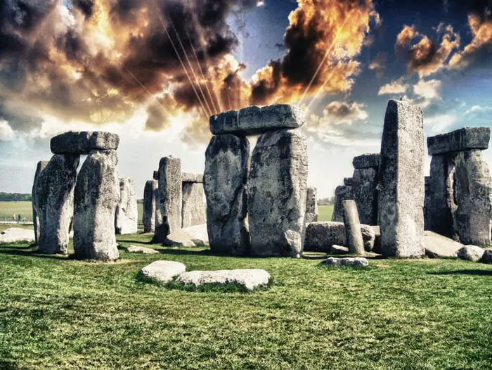
5. Stonehenge—an ancient alien landing pad?
Located outside of Salisbury we find a massive circle composed of stones, ranging in weight between 30 and 60 tons. Believed to have been built during the Neolithic, this fascinating ancient site inspired great authors like Erich von Däniken to ponder whether it’s a massive model of our solar system and whether it may have been used as a landing pad for alien spacecraft.
Today, modern scholars are still unable to decipher the mystery behind Stonehenge. Experts are unable to figure out how the ancient transported the massive stones, nor why they are positioned like they are.
Featured image credit: Leon Tukker. Freelance concept/environment artist and Illustrator.
In the mid-80s, off southern Yonaguni, in Japan, some divers found amazing underwater stone structures which looked like stairs or balconies. Scientist like marine geologist Masaaki Kimura think these “pyramids” are man-made and that date back to thousand of years ago.
YONAGUMI PYRAMIDS ON TV
Story has been enhanced by History Channel (in the episode “Lost cities of the deep” of Ancient Discoveries series), by Bbc and by Discovery Channel, but the question remains: are they wildlife structures or were they created over the surface by a vanished civilization and then were flooded by ocean beacause of a volcanic eruption or an earthquake?
Yonaguni pyramids consist of a series of stone structures, comprising massive layers, as well as various pillars. They lie at a depth between 5 to 40 meters above the surface. The most remarkable structure was named “turtle” because of its similarity with such an animal.
THE CIRCULATION OF MARINE CURRENTS
Because of very strong marine currents, and a large population of hammerhead sharks, diving in these waters isn't fully safe, but this didn't prevent the area to become the most famous for diving in Japan.
Some scientists think that exactly the strong maring currents, jointly to the natural process of erosion, turned for millenia the ocean floor.
TOO MANY CORNERS AND STRAIGHT EDGES
Yonagumi pyramids would therefore be just part of a rock formation. Other experts continue to believe they were man-made, as would seem to indicate the huge number of corners and straight edges, as witness many photos taken over the years.
Whether this view proved to be correct, would arise louder a second question: why, fromwho and for what purpose were built Yonaguni pyramids. Before even gets the the mythical Atlantis, were they and ancient fortified complex, temples, or a mausoleum?
Incredible Similarities Between Ancient Gods In Unconnected Cultures Hint At Ancient Aliens
Incredible Similarities Between Ancient Gods In Unconnected Cultures Hint At Ancient Aliens
What if I told you that all ancient cultures were somehow connected to each other, thousands of years ago.
Have you ever wondered why there are so many similarities among ancient cultures around the globe? Mainstream scholars maintain how cultures in Africa, America, Europe, and Asia weren’t interconnected in ancient times.
Despite these claims, numerous archeological discoveries suggest otherwise.
Take for example ancient monuments scattered across the globe.
Numerous ancient sites in South America show uncanny similarities in design and construction to monuments erected halfway across the world, in Africa for example.
Are these similarities a mere coincidence?
Or is there a possibility that all of these ancient cultures were interconnected somehow.Is it possible, as some ancient astronaut theorists suggest, that an otherworldly entity influenced ancient civilizations around the globe?
How is it possible that the ancient Olmecs, Aztecs, Egyptians, and cultures as those in New Zealand share depictions of their gods—who came down from heaven—which are nearly identical?
Is this just another example of random cultural spread? Or is it possible there is more to it than we are willing to accept?
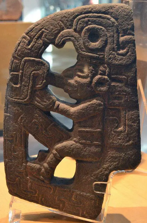
Ancient Olmecs and the La Venta Stele 19
A photo of La Venta Stela 19, the earliest known representation of the Feathered Serpent in Mesoamerica.
‘La Venta’ stele 19 offers the earliest known representation of the Feathered Serpent in Mesoamerica. The feathered serpent was known across ancient cultures in Mexico as either Kukulkan or Quetzalcoatl. This God is said to have arrived from the heavens, and brought great knowledge to ancient cultures.
La Venta is an ancient archaeological site that belonged to the ancient Olmec Civilization. Curiously, the Olmecs were one of the first civilizations to develop in the Americas.
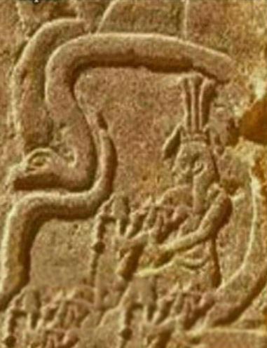
Another depiction of a deity inside of what appears to be a machine?
‘La Venta’ stele 19 offers a curious representation of the feathered serpent: A humanoid figure sitting in some kind of ‘vehicle’ or ‘chair,’ as if manipulating some sort of device.
At first, this may not sound extraordinary or weird.
However, it becomes strange when you find nearly identical representations of gods, halfway around the world.
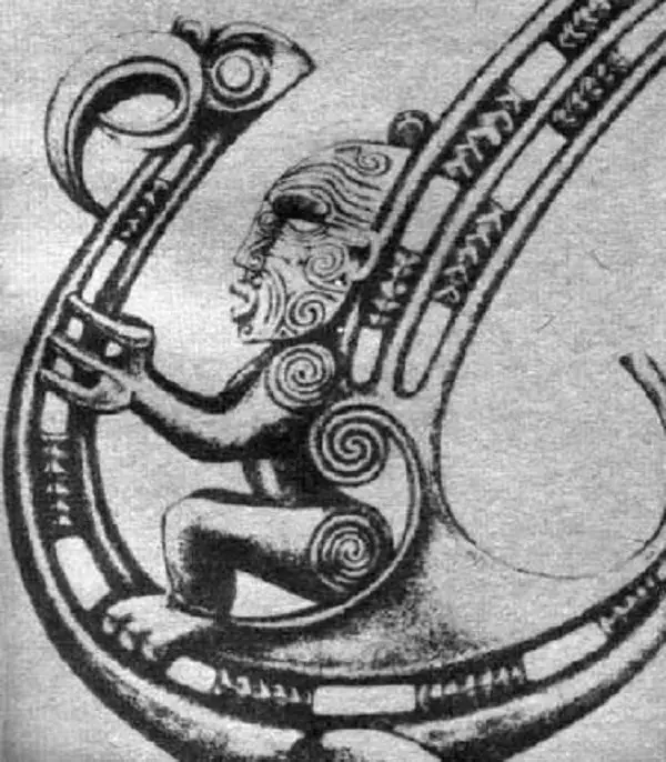
According to the Maori legend, the god Pourangahua flew on his magic ‘bird’ from his legendary dwelling Hawaiki to New Zealand.
Curiously, according to legend, this ancient god came from heaven, riding a ‘silver bird.’
In fact, if we take a look at one of the oldest Maori prayers we will find its attribution to the God Pourangahua.
“I come, and an unknown earth lies below my feet. I come, and a new heaven turns above me. I come on to this earth, and it is a peaceful resting-place for me. O spirit of the planets! The stranger humbly offers you his heart as nourishment.”
If we compare the depiction of the feathered serpent in ancient Mesoamerica folklore to the God Pourangahua, we find a mysterious connection: both are represented nearly identically.
How is this possible? A mere coincidence?
But there is more…
Let’s travel from ancient Maori legends to ancient Egypt.
Another ancient God depicted in a sort of flying ‘snake.
Image Credit: Pinterest.
There, we will find a mysterious representation of the ancient Egyptian God Hapi.
Referred to as the “father of the gods,” Hapi was the god of the annual flooding of the Nile in ancient Egyptian religion. This ancient Egyptian God symbolized fertility. This ancient Egyptian god also was usually given blue or green skin, which according to scholars represents the water.
Take a look at how he is sometimes depicted. Once again, we have a strange similarity to the feathered serpent in Mesoamerica, and the god Pourangahua, in ancient Maori folklore.
Back to Mesoamerica
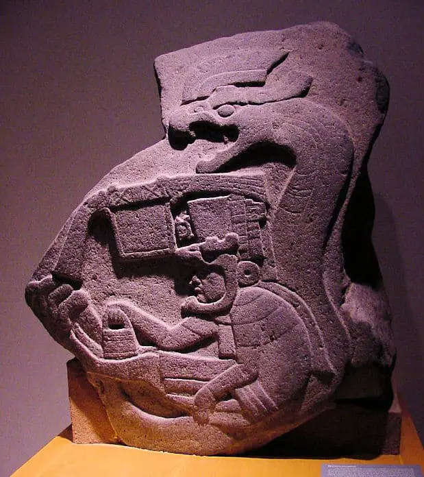
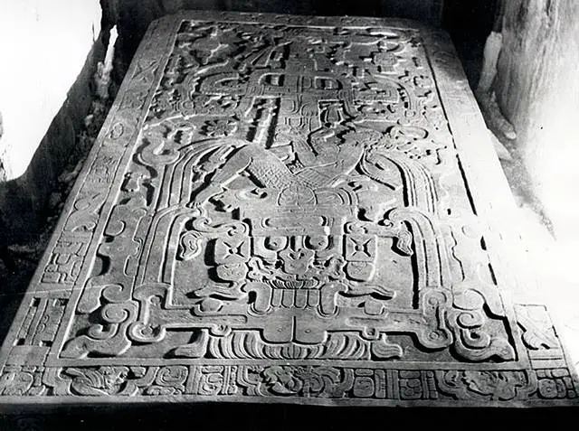
Ancient alien theorists propose that it clearly depicts King Pakal in some sort of spaceship during takeoff, and they argue that his hands appear to be manipulating some sort of machinery.
We venture back to modern-day Mexico where we find another curious representation which has aroused the interest of ancient astronaut theorists: King Pakal.
The sarcophagus of king K’inich Janaab’ Pakal or more commonly known as King Pakal is one of the most talked about subjects when it comes to the ancient alien theory. The sarcophagus lid of this great Maya rulers has some pretty curious depictions.
Ancient alien theorists propose that it depicts King Pakal in some kind of spaceship during takeoff, and they argue that his hands appear to be manipulating some sort of machinery, his foot is located on a pedal while he is breathing through some sort of breathing apparatus. The theory about Pakal’s spaceship was first proposed by Erich von Däniken in his book Chariots of the Gods.
Once again, we see a depiction of a figure inside of some sort of machine.
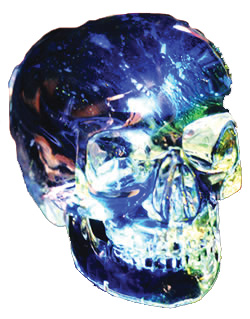
An old native American legend describes the existence of thirteen ancient crystal skulls, the size of human skulls, with moveable jaws that were said to speak or sing. The legend tells that these crystal skulls contain important information about some of the great mysteries of life and the universe. They contain knowledge about the past history of our species on this planet, and information about mankind’s true purpose and future destiny.
The Cherokee version of the legend says that there were originally twelve planets in the universe inhabited by human life and that there was one skull for each of these planets, together with a thirteenth skull which was vital to reconnecting all of these worlds.
The legend also says that one day, at a time of great need, all of these crystal skulls will be rediscovered and brought back together to reveal their information vital to the very survival of the human race. But the legend also warns that when that time arrives mankind must first be sufficiently developed, suitably evolved both morally and spiritually, so as not to abuse this great knowledge.
When we first heard this legend, whilst visiting the ancient Mayan ruins of Tikal in Guatemala, we considered it merely a colourful story, until we found out that a real crystal skull had actually been discovered on an archaeological dig in Central America, way back in the 1920’s.
The Mitchell-Hedges Crystal Skull
Frederick Mitchell-Hedges (1882-1959) was your archetypal British adventurer-explorer; a member of the Maya Committee of the British Museum and a real Indiana-Jones type character determined to make his mark in the twilight years of the British Empire. He was of the opinion that the cradle of civilisation lay not in the Middle East, as is commonly supposed, but instead he was convinced that Atlantis was a real civilisation which had disappeared after some natural catastrophe. He believed that the remnants of this Atlantean civilisation could still be found somewhere in Central America, and he was determined to prove it.
To this end, he gathered together a party of explorers who set sail from Liverpool in 1924 bound for British Honduras (now Belize). One day, deep in the jungle, his party stumbled upon some mounds of stone overgrown with moss and foliage, and suffocated by roots and vines. So they set fire to the undergrowth. When the fire had subsided the ruins of a once great city emerged from the flames.
It was a place known to the local Mayans as ‘Lubaantun’ or ‘The City of Fallen Stones’, and it was in this lost city that Mitchell Hedges’ adopted daughter Anna found a magnificent and perfect crystal skull, buried beneath an altar in the ruins of one of the great temple-pyramids. The Mayan helpers on the dig went wild with joy on the emergence of the skull. They seemed to recognise it. They kissed the ground crying, placed it on an altar, and performed ceremonial rituals and dances around it.
But what was this mysterious object and did it have anything to do with the ancient legend?
In a lost city in a remote jungle, located in what is now Belize, Central America, Anna Mitchell Hedge found this magnificent and perfect crystal skull, buried beneath an altar in the ruins of a great temple-pyramid.
The crystal skull is a mystery as profound as the Pyramids of Egypt, the Sphinx, the Nasca Lines of Peru, or Stonehenge. Ever since its original discovery the crystal skull has been the source of much archaeological controversy – nobody seems to know quite how old it really is, how it was made, what it was used for, and where it originally came from. All that is known for sure is that ever since it emerged from the temple ruins, the most incredible claims have been made about the crystal skull and there have been a whole host of reports of strange and unusual phenomena surrounding the skull.
As mentioned above, Anna Mitchell-Hedges is the woman who first uncovered the crystal skull as a teenager back in the 1920’s. Although the crystal skull was found on what most archaeologists consider to be a Mayan site, Anna Mitchell-Hedges and many others like her believe that it is actually much older than this, and that it belonged to some mysterious pre-Mayan civilisation that has now long since disappeared from this Earth.
The crystal skull has been valued at several millions of dollars, but it is far more than just an expensive and exotic ancient artefact. For, over the years, people have reported all kinds of strange and unusual experiences in the skull’s presence. In particular, it is said to have incredible ‘psychic’ and ‘healing’ powers. According to Anna Mitchell-Hedges, who passed away at the age of 100 in 2007, it is thanks to the ‘healing power’ of the skull that kept her alive. She said that all through her life the skull kept her in good health and happiness. The skull, she said, ‘protected’ her and ‘communicated’ with her all through her long life, and she is not the only person to have reported such experiences.
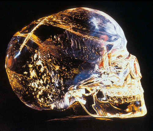
Anna allowed many visitors into her home and she accumulated hundreds of letters from the many people who came to her house to sit with the skull and who claim to have been ‘healed by the skull’ or that it somehow ‘communicated’ with them. Many of those who have spent time alone with the skull claim to have seen or heard things in its presence. Many say they have seen a gentle glow, like an aura, extending around the skull, or that they have heard sounds, like the soft chanting of human voices, emanating from it, such that it has now earned the title ‘the talking’ or ‘singing skull’, just as in the old legend.
Others claim to have seen things inside the skull. When they have sat with the skull for a long time it has started to present them with images, almost like watching a bit of cinema film. Hundreds of visitors attest to having seen incredible images from the past or the future deep inside its crystalline structure. The reports include images of ancient sacred sites, with ceremonies being performed beneath great pyramids. Others say they have seen whole periods of planetary history with great shifting of continents, the rising of sea levels and destruction of land masses, and geological cataclysm on a global scale. One of the most commonly reported images is considered by many to be the holographic image of a UFO appearing within the crystal skull – and this has even been photographed! This image in particular has led many to suggest that perhaps the crystal skull has some kind of strange unearthly origin?
But, just as the ancient legend suggests, this is not the only crystal skull to be discovered. Several other crystal skulls have since come to light. All are of mysterious origin and all are surrounded by claims of strange or unusual phenomena and tales of inexplicable, paranormal powers.
Max, the ‘Talking’ Crystal Skull
A woman named Joann Parks, who lives in Houston, Texas, also has a crystal skull. She, too, claims that her crystal skull has the power to heal and can communicate with her telepathically. The story of how Joann Parks came into possession of her crystal skull starts with a very sad story. In 1978 Joann’s eldest daughter, Diana, was diagnosed as having bone cancer and the conventional medical doctors gave her only three months to live. Joann turned to the help of a Tibetan Lama and healer named Norbu Chen. This man owned a crystal skull, and with the help of this healer and his crystal skull, her daughter managed to live for a further three years. When her daughter eventually died, the healer gave Joann the crystal skull, telling her nothing about it except that he had originally received it from a Guatemalan shaman and that one day Joann would understand it and know what it was for.
Not knowing what to do with it, Joann put the crystal skull in a box in the bedroom closet. A few years later the skull started to appear in her dreams. Then it started “speaking to her,” saying that it wanted out of the closet. She tried to ignore this ‘voice’ but it started “talking to her” at all times of day, saying “You must let me out of this closet. I am important to mankind,” and “I will be remembered.” Joanne thought she was losing her mind and even spoke to her family doctor about it, but the voice just wouldn’t go away, and so she eventually found herself sitting in the bedroom closet “talking to this lump of rock” and telling it to go away, saying “Just leave me alone skull!” She slammed the skull away in a case and pushed it to the back of the wardrobe, but as she ran back down the stairs the skull kept talking to her. “It was very persistent,” explained Joann and it was determined that I take it out of the closet and “tell mankind” of its existence. It even added that, “By the way, my name isn’t skull, it’s Max!” And since that time Joann has been showing the skull all over the United States where she says “Max has now spoken to and healed many people.”
The skull had also told Joanne that it came many thousands of years ago from a civilisation far in advance of our own, and from a dimension different from our own, and that one day soon this is something mankind would understand!
What can we learn from the other crystal skulls that have now been discovered? Recently a massive crystal skull turned up at the Smithsonian Institution in Washington under very sad and mysterious circumstances. It had been sent through the post by an anonymous donor whom it transpired had taken his own life, apparently on account of the ‘curse’ the skull had brought on him since it came into his possession.
The British Museum also has a crystal skull which is kept in The Museum of Mankind, just off Piccadilly Circus, in London. Like the Mitchell-Hedges specimen, this skull is made from highly transparent crystal and displays an incredible degree of anatomical accuracy. This skull has been in the museum’s possession since 1898 and is reported by staff to have been seen moving around by itself in its sealed glass case. The museum’s cleaners are said to be so frightened of this skull that it has to be covered by a cloth before they will go anywhere near it. Where did this skull come from?
The British Museum have always considered their skull to be of Aztec origin. The note accompanying the Smithsonian skull also said that it had once belonged to the mighty Aztecs of Central America. Anna Mitchell-Hedges and Joann Parks said their skulls are at least as old as the ancient Mayan civilisation of Central America, if not far older and perhaps of extraterrestrial origin.
The ancient Aztec and Mayan people built up highly developed civilisations in an incredibly short period of time. These civilisations appeared as if from nowhere and the Mayan civilisation, just as suddenly, mysteriously disappeared.
Many archaeologists are baffled as to where they got their advanced knowledge from and why they suddenly disappeared. All the evidence that remains of this civilisation suggests they were great watchers of the skies and the heavenly bodies. They were great scientists, mathematicians and astronomers. They had a complex calendar based on the movements of the planets and the stars and which they used to predict the future. They were able to predict eclipses, even ones they could not see and that were happening elsewhere in the world. They even managed to accurately predict eclipses that have happened recently – over a thousand years after their own civilisation mysteriously disappeared.
Some researchers claim the Mayan records say their people came from Atlantis and their ancestors before that ‘came from the stars’. The Mayan civilisation was also obsessed with the image of the skull, which made up an important part of their sacred, divinatory calendar.
Modern Fakes?
Many archaeologists, however, unable to explain the strange phenomena associated with the crystal skulls, claim they are simply ‘modern fakes’. So how old are the crystal skulls and where did they really come from? Are they modern, Aztec, Mayan, or did they come from some other civilisation altogether?
In an attempt to try to answer these questions, Anna Mitchell-Hedges loaned her skull to one of the world’s leading computer companies, Hewlett-Packard, for rigorous scientific testing. The scientists in their crystal laboratories were completely unable to determine the age of the skull, as crystal cannot be carbon-dated. But what surprised the scientists was that both the skull and its detachable lower jawbone were made from the same massive piece of pure, natural rock crystal. As crystal is only slightly softer than diamond, this finding was truly incredible.
The scientists concluded that even with modern diamond-tipped power tools, it would have been impossible to carve such an object without it shattering. At first they thought the skull must have been made by hand using sand and water to slowly abrade the material over several generations – a process they estimated must have taken around “300 man-years of effort!” But soon they were forced to revise even this conclusion. For when the skull was examined under intense magnification the scientists were in for an even bigger surprise – they were completely unable to find any evidence of tools having been used to make the skull at all! A fact which led one member of the team to comment: “This skull shouldn’t even exist!”
The crystal skull challenged all conventional opinion. Here was an object that simply defied explanation. It showed no evidence of any existing technology used in its construction, no evidence of tool markings either ancient or modern. But the scientists at Hewlett-Packard said they were simply not prepared to countenance the only alternative explanation – that the skull had not even been made by humans.
The scientists other interesting discovery was that the skull had been made from precisely the same type of quartz now used in modern electronic equipment. Modern science has established that among the unusual properties of quartz crystal is its ability to hold under control electrical energy and to oscillate at a constant and precise frequency. In other words, the crystal skull is able to hold electrical energy – potentially a form of information – and send out vibrating impulses – or waves of energy information. This is why quartz crystal is used for the ‘brain cells’ of electronic equipment such as watches and computers. The silicon crystal chip inside a computer, for instance, is where the information is actually stored. This finding raised the distinct possibility that the crystal skulls are in fact some kind of information storage system, just as the ancient legend suggests. But what might that information be, and where do the crystal skulls really come from?
The Legend of the Crystal Skulls
Native Americans have long believed in the power of quartz crystal. They refer to quartz crystals as “the brain cells of Mother Earth” and have traditionally used them for healing. The crystal skulls have long been a part of Native American teachings but until now they have been forbidden to speak about them. Now, they say, the time has come for them to speak out about these amazing artefacts and to reveal their secret knowledge.
Professor Paula Gunn-Allen of the University of California is of Laguno Pueblo origin. She specialises in Native American literature and is well versed in the mythology and oral history of Native America. According to her the crystal skulls were created by beings “who are not humans like we are.” She says the crystal skulls were designed specifically for the purpose of communication with extraterrestrial life. As she explains, “What they are is transceivers – devices to help us communicate with the other quadrants of the galaxy.” She said that we might think of them “as like telephones” that get you connected with Galactic Central and enable you to stay in touch with “civilisations beyond our littie bitty modern world.”
Native American medicine woman Jamie Sams says that “the crystal skulls contain information about our own ancestors, about our own past and our own future that will very soon change the whole way we see ourselves, our world, and our true place in the universe.”
According to Metis Cherokee medicine man Harley Swiftdeer, the full version of the legend of the crystal skulls says that there were originally twelve planets in the universe inhabited by human life; that there was one skull for each of these planets, and a thirteenth skull which was vital to finally reconnecting all of these worlds. According to Harley Swiftdeer and other native Americans, the crystal skulls were brought to this Earth as “gifts from the gods” – brought long ago by these beings from elsewhere in the universe.
These crystal skulls contained the wisdom necessary to found civilisation on this Earth and when all thirteen crystal skulls are brought back together again, we will have finally found the key to reconnecting with our brothers and sisters elsewhere in this beautiful universe.
If you appreciate this article, please consider a digital subscription to New Dawn.
CHRIS MORTON & CERI LOUISE THOMAS are independent television producers who specialise in making films with a philosophical, spiritual or environmental emphasis. Their highly-acclaimed documentary ‘The Mystery of the Crystal Skulls’ has been shown around the world. They are also the authors of the best selling book, The Mystery of the Crystal Skulls.
Ancient—draft—manuscript of the Bible found, reveals shocking details
Ancient—draft—manuscript of the Bible found, reveals shocking details
Some argue that this ancient manuscript proves how the Bible is in fact a work of fiction. The King James Bible was created after King James I ordered 47 translators to produce an ‘authorized’ version of the Bible that would support the English Church over Puritan influence in earlier texts.
Kept hidden away for centuries among ancient manuscripts lodged in the Cambridge college remain an ancient manuscript which turned out to be the EARLIEST known DRAFT of the King James Bible—arguably the most widely read work of literature in the English language.
But why does this matter so much? Well, the Bible is a compilation of ancient early texts and translations, and this ancient manuscript shows how one of the translators in charge of translating the King James Bible—Samuel Ward—made several drafts and corrections—based on earlier versions of the Bible—in order to obtain the King James Bible.
Author Samuel Ward was one of a team of seven men in Cambridge who worked on the translation of the King James Bible.
The manuscript was discovered by American scholar Jeffrey Miller who came across some 70 handwritten papers believed to date back between 1604 and 1608 in ancient archives, containing biblical commentary, with Greek and Hebrew notes. The manuscript had eluded researchers in the past because it was mislabeled—remaining undetected and without any study for centuries.
Miller argues how the discovery of the manuscript will help fill in gaps that will allow us to better understand how the bible—which was published d in 1611—came to be.
“There was a kind of thunderstruck, leap-out-of-the-bathtub moment,” Miller, told the New York Times in an interview.
“But then comes the laborious process of making sure you are correct.”
The King James Bible is the English translation of the Christian Bible made for the Church of England which begun in 1604 and was completed in 1611. The books of the King James Version contain the 39 books of the Old Testament, as well as intertestamental section containing 14 books of the Apocrypha, and the 27 books that make up the New Testament.
The KJB is the result of 7 translators working in teams working in London, Oxford, and Cambridge. King James I ordered them to produce an ‘authorized’ version of the Bible that would support the English Church over Puritan influence in earlier texts.
Many authors argue that entire sections of the original texts of the Bible were cut out from the ‘finished product’ and notable people and events were entirely omitted from the finished text.
Writing about the discovery, Miller— from Montclair State University in New Jersey—indicates how Ward’s ‘draft’ “helps to reveal about one of the 17th century’s most extraordinary cultural achievements.”
“It points the way to a fuller, more complex understanding than ever before of the process by which the KJB, the most widely read work in English of all time, came to be,” added Miller.
Discoveries like these raise questions on how much translators influenced the final product and whether or not, the King James Bible is today an ancient text based on the actual truth and events that occurred thousands of years ago.
New Fossil Found Places Modern Humans in Western Asia 195,000 years ago
New Fossil Found Places Modern Humans in Western Asia 195,000 years ago
Long before the ancestors of living people today entered Eurasia 60,000 years ago, other Homo sapiens groups had already occupied parts of the continent. Fossil finds have already recently established that early modern humans settled in the Levant and East Asia by 120,000 years ago, but a new discovery is further eroding the pre-existing consensus model.
Scientists have confirmed the presence of an archaic Homo sapiens jaw fragment and a significant number of skilfully worked stone tools present at the Misliya Cave site, one of Mt Carmel’s many caves. The article published on the research project, Israelifossils are the oldest modern humans ever found outside of Africa,appeared in the science journal Nature. This story has initiated a wave of worldwide media attention. The archaeological site is situated just a few kilometres away from the Skhul cave, which has previously produced modern human remains dated at 80,000–120,000-year-old. The new find was so much older than the team spent several years ensuring all possible checks were done to validate the find and assign it to the correct species, in this instance archaic Homo sapiens. After considerable analysis, the jaw fragment was dated at 177,000–194,000 years ago.
“We called it ‘Searching for the Origins of the Earliest Modern Humans’. This was what we were looking for,” says Mina Weinstein-Evron, an archaeologist at the University of Haifa in Israel.
A close-up view of the teeth on the newly reported fossil. They’re a little on the big side, but within modern human range, researchers say.
(Supplied: Israel Hershkovitz, Tel Aviv University)
It is usually thought that early modern humans in the Levant and the Middle East were unable to expand beyond this region into Eurasia, dying out by some unknown mechanism, the assumption being that they had flowed out from Africa. There is no solid evidence to say these groups did indeed emerge from Africa of course. With recent confirmation that the Chinese Dali Skull is that of an archaic Homo sapiens individual (from 260,000 years ago), we must keep a degree of scepticism regarding the mainstream scientists’ assumptions on the geographic origins of this population.
Professor Hiscock, an archaeologist from the University of Sydney, has raised the question of whether this individual was an ancestor of living humans and also commented on the claim that these early modern humans were unable to expand beyond the Levant.
“If that’s true, why did they die out and why were our ancestors able to move out when these people didn’t, given that they’re anatomically the same as us?” he said.
Human origins are a rather murky business, there is no definitive narrative to this story beyond a few fixed points between which lines can potentially be drawn in multiple (at times conflicting) directions. The first thing anyone that follows palaeoanthropology should recognise is that the entire subject is dependent not so much on archaeological and genetic evidence as it is on accurate interpretations and sensible assumptions. There is currently no sample of Homo sapiens DNA older than 45,000 years, and the fossil record for archaic Homo sapiens is sparse. This means any favoured human origins hypothesis can change rapidly on the turn of a trowel.
This incredibly ancient human bone further erodes the waning recent out of Africa model, not only were early modern human populations living beyond Africa 120,000 years ago but that they had already colonised western Eurasia almost 200,000 years. This date from Israel is virtually contemporary with those of the oldest early modern human remains found in East Africa, at 160,000 – 195,000 years of age (the Omo and Herto Skulls).
This latest announcement comes hot on the heels of several other ‘problematic’ findings, including a new status for China’s Dali Skull, now identified as being that of a 260,000-year-old archaic Homo sapiens. The other major upset for existing models involved the detection of an interbreeding event between Neanderthals and archaic Homo sapiens which occurred somewhere in Eurasia around 270,000 years ago, emerging from the study of a Neanderthal bone at the Hohlenstein-Stadel archaeological site in Germany. The Hohlenstein-Stadel genetic study was published by Nature in late 2016, under the title Deeply divergent archaic mitochondrial genome provides lower time boundary for African gene flow into Neanderthals.
When we factor in additional discoveries of potential early Homo sapiens populations living at Jebel Irhoud in Morocco around 300,000 years ago and others in China at dates closely matching those of the Dali skull, we begin to recognise Homo sapiens as a highly mobile and widespread species even from their very earliest appearance in the fossil record. It is time to completely abandon any romantic idea of a human genesis in an Eden-like human enclave somewhere in East Africa around 200,000 years ago.
“The fossil could indicate that Israel and the rest of the Arabian Peninsula were part of a larger region in which H. sapiens evolved”, says John Shea, an archaeologist at Stony Brook University in New York.
Perhaps the most intriguing implication of these very early modern human population in the Levant is that we no longer require a migration 120,000 years ago to explain fossils from that later period. It may well be that these more recent human populations were the descendants of the former archaic Homo sapiens present across the continent. Perhaps it is time for us to be more sceptical of claims involving additional migrations out of Africa and consider other interpretations of the available evidence.
The Prambanan Temple Compound: The 240 Ancient Rocket-Like Hindu Structures
The Prambanan Temple Compound: The 240 Ancient Rocket-Like Hindu Structures
Prambanan is a set of more than 200 Hindu temples built in the distant past and dedicated to the Trímurti, the expression of God as the Creator (Brahma), the Preserver (Vishnu) and the Destroyer (Shivá).
This magnificent ancient site is located about 18 km east of Yogyakarta.
The temples are believed to have been built during the 9th century under the Sanjaya dynasty of the first Kingdom of Mataram in the Central Java region.
An inscription dated in the year 856 marks what is possibly its founding stone.
Prambanan is considered the most significant Hindu temple site in Indonesia, and one of the biggest in Southeast Asia.
The stunning rocket-like structures are characterized by its tall and pointed architecture style, which, according to historians, are typical of Hindu architecture and by a towering 47-meter-high central building inside a large complex of individual temples. Scholars note that the design of Prambanan temple follows the typical Hindu architecture traditions based on Vastu Shastra— a traditional Hindu system of architecture which translates to “science of architecture.
According to the Shivagrha inscription of 856 CE, the Prambanan Temple Compound was built to honor Lord Shiva. Scholars argue that its original name was either Shiva-grha (the House of Shiva) or Shiva-laya (the Realm of Shiva).
Its architecture is unlike anything I’ve ever come across.
According to historical reference, there were originally 240 temples standing in Prambanan.
3 Trimurti temples: The three main temples dedicated to Shiva, Visnu, and Brahma.
3 Vahana temples: three temples in front of Trimurti temples dedicated to the vahana of each gods; Nandi, Garuda, and Hamsa.
2 Apit temples: two temples located between the rows of Trimurti and Vahana temples on north and south side.
4 Kelir temples: four small shrines located on 4 cardinal directions right beyond the 4 main gates of inner zone.
4 Patok temples: four small shrines located on 4 corners of the inner zone.
224 Pervara temples: hundreds of temples arranged in 4 concentric square rows; numbers of temples from inner row to outer row are: 44, 52, 60, and 68.
As noted by Lonely Planet, the temple compound suffered extensive damage in the 2006 earthquake. Although the temples survived, hundreds of stone blocks collapsed to the ground and cracked (479 in the Shiva temple alone).
Two men are seen viewing a display entitled 'The Problem of Piltdown Man'. The cranial fragments, found at Piltdown, Sussex, from 1908 to 1912, were formally denounced as fakes in 1953, for being comprised of the bones of a man and an ape.
REG SPELLER/FOX PHOTOS/GETTY IMAGES
Unearthing and studying bones and fossils is one of the many ways scientists work to better understand humanity's shared history and evolution. But some discoveries have created more questions than answers. Could these abnormal archaeological finds be evidence of extraterrestrial life? The missing evolutionary link between man and ape? Proof of alien-human hybrids? Or are they just elaborate hoaxes?
Stuff They Don't Want You To Know hosts Matt Frederick, Ben Bowlin and Noel Brown dig deep into the Strange World of Inexplicable Skeletons to separate the myths from the mysteries in this episode of the podcast.
It would be easy to dismiss all these remarkable discoveries as nothing but hoaxes for money or fame, mainly because they've happened so many times. Most famously, the Piltdown Man, discovered by amateur archaeologist Charles Dawson in 1912, was touted as being the missing link between man and ape. Its skull, supposedly 500,000 years old, was shaped like an orangutan's, but its teeth and jawbone were closer to a human's. It wasn't until 1949 that the Piltdown Man skull was re-tested using newer techniques and found to be a fake. It was created from an artificially aged orangutan skull whose teeth had been filed down.
Another famous hoax involved a crystal skull owned by Anna Mitchell-Hughes, who claimed to have discovered it in a Mayan ruin with her explorer father, while searching for the lost city of Atlantis. (It's always the last place you look.) Mitchell-Hughes said the Mayans told her the skull was used to transfer the knowledge of an elder to a younger member of the tribe before the elder died. However, it was discovered fairly quickly that Mitchell-Hughes had simply bought the skull at an auction at Sotheby's, and according to experts, crystal skulls are usually no more than 150 years in age, made with modern tools and techniques not found in ancient civilizations.
The Fiji, or Feejee, Mermaid made quite a splash when it was exhibited in New York in 1842 by Dr. J. Griffith. But it, too, turned out to be fake, orchestrated by the greatest showman himself, P.T. Barnum. The "mermaid" turned out to be the top half of a monkey attached to a fishtail, and "Dr." Griffith was simply Barnum's accomplice. Quite a bit of ticket money was made before the two men's secret was out.
But some skeletons are obviously real, and puzzling enough to require further investigation. In 1999, the now-late paranormal researcher Lloyd Pye claimed he obtained a human-alien hybrid skeleton he called "Starchild," which was found in 1930 in a tunnel southwest of Chihuahua, Mexico. The skull was larger than average and flattened on the back, leading Pye to surmise it was the offspring of an alien and a human female. (Quite a leap.) But DNA evidence has since proven the skull is from a human, and most likely that of a child who died from congenital hydrocephalus, a condition that causes the brain to swell.
Similarly, the Paracas skulls were seen as proof of aliens among us; the skulls were elongated, like cones, and were originally reported as having mutations not found in any human species. Further testing found that they also were human, despite their appearance. More likely, the elongated shape was the result of a tribal practice called artificial cranial deformation, which was done for a variety of cultural reasons.
Perhaps most puzzling of all is the 6-inch-long (15-centimeter-) skeleton found in the Atacama Desert in Chile in 2003. It is a fully-formed human, only miniature, leading many to believe that it's a fetus or a very young child. But tests on the bones have shown growth plates similar to those of a 6- to 8-year-old child, and there appear to be mature teeth in its mouth. How could a 6-year-old only be 6 inches long? And what about the Kyshtym dwarf, the Littlemore Priory and the Peruvian three-fingered mummy? You'll have to listen to the entire podcast to find out all about these.
Lost Continent? Scientists Find Parts Of North America In Australia
Lost Continent? Scientists Find Parts Of North America In Australia
Georgetown, in northern Queensland (Australia), was once part of North America say, researchers.
That is what seems to suggest the finding and subsequent study of a series of rocks and fossils in the area.
If so, it would mean that Australia was connected to Canada about 1.7 billion years ago.
The idea that the two continents were once connected is not surprising.
Such Speculations have existed since the late 1970s, when scientists proposed that this connection dated back to the continent of Rodinia, about 1.13 billion years ago.
However, and even under that theory, a date was missing.
The findings in Georgetown, a small town in northeastern Australia, now seem to be a boost to that theory.
The rocks found in Georgetown are different from all other rocks on the Australian continent.
However, they show enormous similarities to ancient rocks found in Canada, in the exposed section of the continental crust called the Canadian Shield.
An unexpected finding, according to researchers at Curtin University, Monash University and the Queensland Geological Survey in Australia, which reveals something about the composition of the ancient supercontinent Nuna.
According to Adam Nordsvan, principal investigator: “Our research shows that about 1,700 million years ago, Georgetown rocks were deposited in shallow water when the region was part of North America. Georgetown separated from North America and collided with the Mount Isa region in northern Australia some 100 million years later. This was a fundamental part of the global, continental reorganization when almost all the continents on Earth came together to form the supercontinent called Nuna.”
The last time the continents were close to each other was the great supercontinent known as Pangea, which split about 175 million years ago.
However, before Pangea, the planet went through several configurations of supercontinents, one of which was Nuna, also called Columbia, which existed about 2,500 million to 1,500 million years ago.
The team of researchers came to this conclusion after examining sedimentological data, and new existing geochronological data from Georgetown and Mount Isa, another remote city in northeastern Australia, and comparing everything to rocks from Canada.
“Ongoing research by our team shows that this mountain belt, in contrast to the Himalayas, would not have been very high, suggesting the final continental assembling process that led to the formation of the supercontinent Nuna was not a hard collision like India’s recent collision with Asia,” said co-author Zheng-Xiang Li.
“This new finding is a key step in understanding how Earth’s first supercontinent Nuna may have formed, a subject still being pursued by our multidisciplinary team here at Curtin University.”
The research has been published in the journalGeology.
The 2-mile-long Marree Man is the second largest geoglyph in the world but nobody knows who made it
The 2-mile-long Marree Man is the second largest geoglyph in the world but nobody knows who made it
Boban Docevski
The first thought that comes to mind when beholding it is that this enormous piece of land art was made by the ancients to serve as a sign for the gods, or as a mythical representation of some tribal hero. But this is not the case with the Marree Man, the second largest geoglyph in the world. It was discovered recently after a plane flew over it in 1998, and it was probably created recently as well. The only problem is, nobody knows who made it or why.
Although it was the 1990s and information about somebody doing something traveled fast, somehow an individual or a group of artists managed to get to this hardly accessible part of South Australia, on the plateau of Finnis Springs, just outside an Australian military base called Woomera Prohibited Area, and created this huge geoglyph with a perimeter of 17 miles. It was definitely a massive undertaking that demanded a lot of labor, and it is strange how nobody noticed–especially because it was close to a big military base.
On June 26, 1998, Trec Smith, a local pilot, flew from the nearby town of Marree to Cooper Pedy and noticed the drawing that was spread across the whole plateau. Later, a hotel in the area claimed that they received an anonymous fax with the coordinates of the geoglyph. Soon the Marree Man geoglyph became headline news across Australia. A big part of the fascination lay in the fact that nobody knew who actually made it. It seemed like some extraterrestrials came and did it in a few seconds.
Marree Man
So what is the Marree Man? Visually speaking, the Marree man is a depiction of a man who holds a boomerang (or a woomera–a throwing stick that was used to chase away birds). Upon examination, it was discovered that the lines of the Marree man were about 8 to 12 inches deep and 114 feet wide. The whole figure is an astonishing 2.6 miles long, and it takes up a perimeter of 17 miles.
The following year, the media was anonymously informed that a small plaque was buried just 16 feet south of Marree Man’s nose. The plaque turned out to be a little American flag with Olympic rings over it. The short text on the plaque reads:
“In honour of the land they once knew. His attainments in these pursuits are extraordinary; a constant source of wonderment and admiration.”
Research was done on this quote, and it was discovered that it comes from a 1946 book written by H. H. Finlayson called The Red Centre. The book is about the hunters of the Pitjantjatjara tribe–the tribe that lives around the Uluru rock formation. These particular words come from a chapter in which the author describes how wallabies were hunted with the use of throwing sticks. The section also describes the look of the hunters, who were naked and had initiation marks on their bodies.
The media received another anonymous message with the name of the artwork. Supposedly it was called “Stuart’s Giant,” after John McDouall Stuart, the famous explorer who led the first expedition across Australia.
Reception of the newly created geoglyph was mixed but mainly positive. A lot of people wanted it to stay. After all, it started bringing tourists to the area. One of the local newspapers, the Advertiser,wrote that the land drawing should be made permanent. Because of the weather conditions in the region, the Marree Man started to erode and disappear. By 2013 it was barely visible, so people demanded that the lines should be made deeper; down to the white chalk layer beneath the ground. Those that were against it, like Dorothy Kotz, the Minister for Environment and Heritage at the time, described the figure as “environmental vandalism.” David Ruthman, who was the Minister for Aboriginal affairs called it “graffiti.”
There are two main theories about the author of this modern geoglyph. According to some people, it was made by Aboriginal artist Bardius Goldberg, who died in 2002. He was the perfect suspect. He lived in Alice Springs and had often discussed his wish to create a piece of art that would be visible from space. One of his friends said that he received $10,000 during the time when the figure was discovered. Goldberg never confirmed nor denied this claims.
Approximate location of Marree Man.
Another theory is that the geoglyph was made by a group from the United States. This is possible because of several facts. First of all, the description of the figure is written in feet instead of meters; also, the term Aboriginal “reservations” is mentioned, and this word is never used to describe the Aborigines. Another clue is a jar that was found buried near the Marree Man. In it, an American flag, together with a satellite picture of the geoglyph, was found. There was also a note in which the infamous Branch Davidian sect was mentioned. Despite all the clues, the creation of the Marree Man is still a mystery.
Mystery aside, this geoglyph is still an attraction. In 2016, its decaying lines were fixed with the help of a satellite-guided tool. Now it is visible again, and although the area is off-limits, those who want can take a flight over it and see it.
Beste bezoeker, Heb je zelf al ooit een vreemde waarneming gedaan, laat dit dan even weten via email aan Frederick Delaere opwww.ufomeldpunt.be. Deze onderzoekers behandelen jouw melding in volledige anonimiteit en met alle respect voor jouw privacy. Ze zijn kritisch, objectief maar open minded aangelegd en zullen jou steeds een verklaring geven voor jouw waarneming! DUS AARZEL NIET, ALS JE EEN ANTWOORD OP JOUW VRAGEN WENST, CONTACTEER FREDERICK. BIJ VOORBAAT DANK...
Druk op onderstaande knop om je bestand , jouw artikel naar mij te verzenden. INDIEN HET DE MOEITE WAARD IS, PLAATS IK HET OP DE BLOG ONDER DIVERSEN MET JOUW NAAM...
Druk op onderstaande knop om een berichtje achter te laten in mijn gastenboek
Alvast bedankt voor al jouw bezoekjes en jouw reacties. Nog een prettige dag verder!!!
Over mijzelf
Ik ben Pieter, en gebruik soms ook wel de schuilnaam Peter2011.
Ik ben een man en woon in Linter (België) en mijn beroep is Ik ben op rust..
Ik ben geboren op 18/10/1950 en ben nu dus 74 jaar jong.
Mijn hobby's zijn: Ufologie en andere esoterische onderwerpen.
Op deze blog vind je onder artikels, werk van mezelf. Mijn dank gaat ook naar André, Ingrid, Oliver, Paul, Vincent, Georges Filer en MUFON voor de bijdragen voor de verschillende categorieën...
Veel leesplezier en geef je mening over deze blog.