The purpose of this blog is the creation of an open, international, independent and free forum, where every UFO-researcher can publish the results of his/her research. The languagues, used for this blog, are Dutch, English and French.You can find the articles of a collegue by selecting his category. Each author stays resposable for the continue of his articles. As blogmaster I have the right to refuse an addition or an article, when it attacks other collegues or UFO-groupes.
Druk op onderstaande knop om te reageren in mijn forum
Zoeken in blog
Deze blog is opgedragen aan mijn overleden echtgenote Lucienne.
In 2012 verloor ze haar moedige strijd tegen kanker!
In 2011 startte ik deze blog, omdat ik niet mocht stoppen met mijn UFO-onderzoek.
BEDANKT!!!
Een interessant adres?
UFO'S of UAP'S, ASTRONOMIE, RUIMTEVAART, ARCHEOLOGIE, OUDHEIDKUNDE, SF-SNUFJES EN ANDERE ESOTERISCHE WETENSCHAPPEN - DE ALLERLAATSTE NIEUWTJES
UFO's of UAP'S in België en de rest van de wereld Ontdek de Fascinerende Wereld van UFO's en UAP's: Jouw Bron voor Onthullende Informatie!
Ben jij ook gefascineerd door het onbekende? Wil je meer weten over UFO's en UAP's, niet alleen in België, maar over de hele wereld? Dan ben je op de juiste plek!
België: Het Kloppend Hart van UFO-onderzoek
In België is BUFON (Belgisch UFO-Netwerk) dé autoriteit op het gebied van UFO-onderzoek. Voor betrouwbare en objectieve informatie over deze intrigerende fenomenen, bezoek je zeker onze Facebook-pagina en deze blog. Maar dat is nog niet alles! Ontdek ook het Belgisch UFO-meldpunt en Caelestia, twee organisaties die diepgaand onderzoek verrichten, al zijn ze soms kritisch of sceptisch.
Nederland: Een Schat aan Informatie
Voor onze Nederlandse buren is er de schitterende website www.ufowijzer.nl, beheerd door Paul Harmans. Deze site biedt een schat aan informatie en artikelen die je niet wilt missen!
Internationaal: MUFON - De Wereldwijde Autoriteit
Neem ook een kijkje bij MUFON (Mutual UFO Network Inc.), een gerenommeerde Amerikaanse UFO-vereniging met afdelingen in de VS en wereldwijd. MUFON is toegewijd aan de wetenschappelijke en analytische studie van het UFO-fenomeen, en hun maandelijkse tijdschrift, The MUFON UFO-Journal, is een must-read voor elke UFO-enthousiasteling. Bezoek hun website op www.mufon.com voor meer informatie.
Samenwerking en Toekomstvisie
Sinds 1 februari 2020 is Pieter niet alleen ex-president van BUFON, maar ook de voormalige nationale directeur van MUFON in Vlaanderen en Nederland. Dit creëert een sterke samenwerking met de Franse MUFON Reseau MUFON/EUROP, wat ons in staat stelt om nog meer waardevolle inzichten te delen.
Let op: Nepprofielen en Nieuwe Groeperingen
Pas op voor een nieuwe groepering die zich ook BUFON noemt, maar geen enkele connectie heeft met onze gevestigde organisatie. Hoewel zij de naam geregistreerd hebben, kunnen ze het rijke verleden en de expertise van onze groep niet evenaren. We wensen hen veel succes, maar we blijven de autoriteit in UFO-onderzoek!
Blijf Op De Hoogte!
Wil jij de laatste nieuwtjes over UFO's, ruimtevaart, archeologie, en meer? Volg ons dan en duik samen met ons in de fascinerende wereld van het onbekende! Sluit je aan bij de gemeenschap van nieuwsgierige geesten die net als jij verlangen naar antwoorden en avonturen in de sterren!
Heb je vragen of wil je meer weten? Aarzel dan niet om contact met ons op te nemen! Samen ontrafelen we het mysterie van de lucht en daarbuiten.
15-09-2024
Trilobites Had Five Pairs of Head Appendages, New Fossils Show
Trilobites Had Five Pairs of Head Appendages, New Fossils Show
Based on multiple analytical techniques applied to well-preserved soft-bodied specimens of two trilobite species, the Late Ordovician species Triarthrus eatoni and the Middle Cambrian species Olenoides serratus, paleontologists argue that an additional pair of cephalic appendages occurred just behind the antennae, indicating that trilobites had five pairs of cephalic appendages and six segments.
Trilobites are extinct arthropods that dominated the faunas of the oceans of the Paleozoic era.
During their time on Earth, which lasted much longer than the dinosaurs, they survived two major episodes of mass extinctions and dominated ocean floor ecosystems.
They appeared in ancient oceans in the Early Cambrian, about 540 million years ago — well before life emerged on land, and disappeared in the mass extinction at the end of the Permian, about 252 million years ago.
They were extremely diverse, with about 20,000 species, and their fossil exoskeletons can be found all around the world.
Like other arthropods, the bodies of trilobites are made up of many segments, with the head region comprised of several fused segments.
As with other parts of the trilobite body (thorax and tail), these segments were associated with appendages, which ranged in function from sensing to feeding to locomotion.
“The number of these segments and how they are associated with other important traits, like eyes and legs, is important for understanding how arthropods are related to one another, and therefore, how they evolved,” said Dr. Melanie Hopkins, curator and chair of the Division of Paleontology at the American Museum of Natural History.
The segments in the trilobite head can be counted in two different ways: by looking at the grooves (called furrows) on the upper side of the trilobite fossil’s hard exoskeleton, or by counting the pairs of preserved antennae and legs on the underside of the fossil.
The soft appendages of trilobites are rarely preserved, though, and when looking at the segments in the trilobite head, researchers regularly find a mismatch between these two methods.
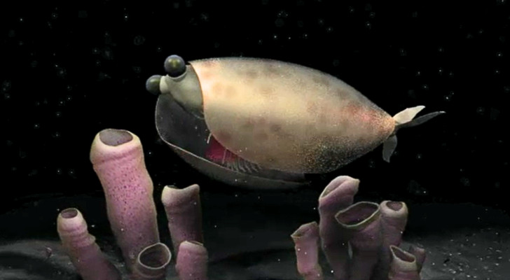
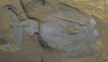
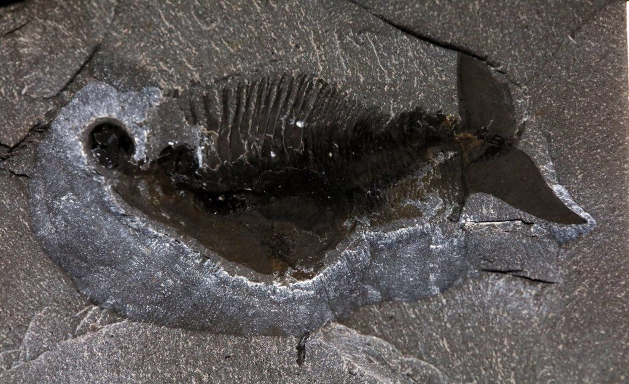
In the new study, Dr. Hopkins and Nanjing University’s Dr. Jin-Bo Hou examined new specimens of Triarthrus eatoni.
These fossils, known for the gold shine of the pyrite replacement preserving them, show an additional, previously undescribed leg underneath the head.
“This fantastic preservation style allows us to observe 3D appendages in hundreds of specimens directly from the ventral side of the animals, just like looking at the appendages of horseshoe crabs on a beach by grabbing them and turning them upside down,” Dr. Hou said.
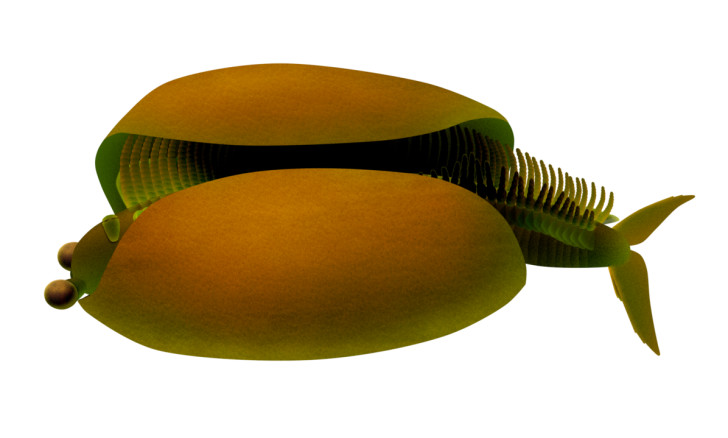
By making comparisons with another trilobite species, the exceptionally preserved Olenoides serratus from the Burgess Shale in British Columbia, the authors propose a model for how appendages were attached to the head in relation to the grooves in the exoskeleton.
“This model resolves the apparent mismatch and indicates that the trilobite head included six segments: an anterior segment associated with the developmental origin of the eyes and five additional segments, associated with one pair of antennae and four pairs of walking legs, respectively,” they explained.
Rare Fossils of Ancient Trilobites
Triumph of the Trilobites
Their paper was published today in the journal Palaeontology.
Jin-bo Hou & Melanie J. Hopkins. 2024. New evidence for five cephalic appendages in trilobites and implications for segmentation of the trilobite head. Palaeontology 67 (5): e12723; doi: 10.1111/pala.12723
Who built these 100,000-year-old megalithic structures in the remote wilderness of Siberia?
Who built these 100,000-year-old megalithic structures in the remote wilderness of Siberia?
In the remote wilderness of the Shoria Mountains in southern Siberia, a long-hidden secret has remained untouched for millennia. Far from the reach of modern civilization, a discovery was made that would challenge our understanding of ancient human history.
In 2013, a team of 19 researchers, led by Georgy Sidorov, embarked on an expedition to explore this mysterious region. Their destination was Gora Shoria, a mountain towering 3,600 feet above sea level in a remote part of Russia. Intrigued by reports of strange megalithic structures, the team ventured into this secluded terrain.
What they found was extraordinary: an immense super-megalith dating back roughly 100,000 years that defied conventional history. These massive stone blocks, later known as the Gornaya Shoria Megaliths, appeared to be made of granite, featuring flat surfaces and precise right angles. The most astounding detail was the weight of the stones, exceeding 3,000 tons—making them the largest megaliths ever discovered.
The arrangement of these granite blocks suggested a deliberate design, far beyond what could be explained by natural formations. The blocks were carefully stacked, reaching a height of approximately 140 feet. This raised profound questions: how were such massive stones carved, transported, and assembled in this remote and rugged landscape?
Some researchers have speculated about the existence of a pre-flood civilization, a sophisticated society wiped out by a cataclysmic event.
Also a deep, narrow vertical shaft was uncovered. The shaft, lined with parallel stone slabs, appeared to be human-made.
The walls of the shaft were straight and polished, descending 40 meters (around 130 feet) before opening into a vast underground hall, 36 meters (around 118 feet) high. These walls were constructed from large megalithic blocks, perfectly fitted with minimal gaps. Some of the stones resembled columns, reinforcing the idea of deliberate design. The full explored length of the shaft spanned over 100 meters (approximately 350 feet).
The precision and scale of this structure left no doubt that it was an artificial creation of immense proportions. The polished walls and massive blocks bore a striking resemblance to the shafts within the Great Pyramid of Khufu in Egypt, suggesting a level of architectural sophistication that defies conventional explanations.
Speculation abounds regarding the shaft’s original purpose. Some believe it served an advanced technological function or was part of a larger, undiscovered structure. The exploration team took over an hour to reach the bottom of the shaft, which required significant climbing expertise and endurance. It is believed that additional chambers and channels, still unexplored, may lie even deeper underground.
How could these gigantic 200-ton stone blocks have been assembled with such accuracy, deep underground? What kind of technology was used to construct the shaft and underground chamber?
Some researchers have speculated that it may have been part of an ancient factory, a seismological research device, or even an energy generator. Others believe it was the underground portion of a long-lost pyramid that once stood on the surface of the mountain.
Despite differing theories, we may wonder what ancient forces or lost civilizations left their mark on this remote corner of the world?
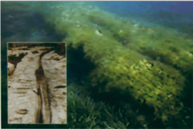
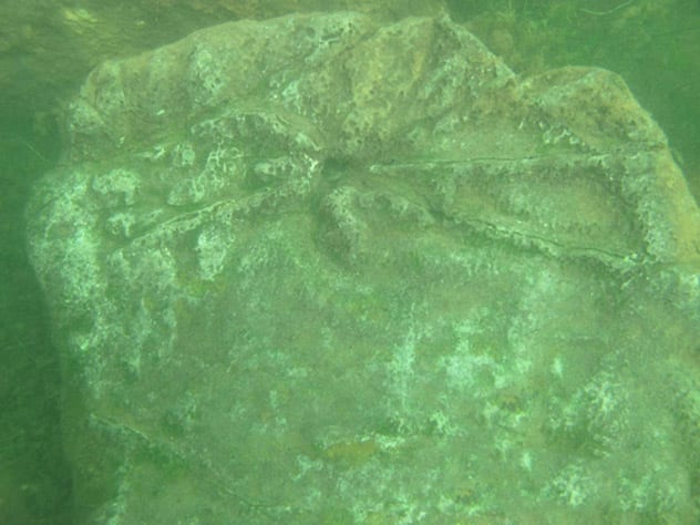
There are underwater ruins almost everywhere around the world. However, some stand out more than others due to the suggestion that they might prove lost civilizations existed in the deep past. And, in turn, might even suggest some truth in the many flood myths that also exist around the planet. Many of these aquatic ruins feature huge megalithic structures, many of which appear to have an intelligent design behind them. Other locations even feature inscriptions of strange symbols and letters in unknown languages. Given that we know very little of what lies beneath the oceans and seas of our planet, who knows what might be awaiting discovery under the still unexplored ocean floors.
10. Underwater Step-Pyramid Off The Coast Of Yonaguni
Freediving Yonaguni Pyramid | Aliens or Lost Civilization? | Yonaguni Monument
Perhaps the first name connected to the underwater ruins at Yonaguni Jima[1] off the coast of Japan is Masaaki Kimura. The marine geologist has spent almost two decades studying the ruins. According to Kimura, there are clearly several artificial structures below the waves in the region. One of these even appears to be a “complicated, monolithic, stepped pyramid”. And what’s more, this particular building is over 80 feet tall.
Initially, Kimura would claim that the remains were likely evidence of Mu – an apparently lost continent in the Pacific. He would even claim the dates of ruins to be around 10,000 years old placing them around 8000 BC. He would, however, eventually revise these dates to around between 5000 to 3000 years old.
Despite the revised estimate of the age, though, some researchers remain supportive of the initial estimation. Perhaps most notable of these is Graham Hancock. Hancock has also written of such ruins, most extensively in his book Underworld.
We should also state that not everyone is even convinced the ruins are artificial structures at all. Boston University’s Robert Schoch, for example, would state in 2007 that the remains were most likely “all-natural”. Further study and investigation will likely continue at the site. As will the debate as to what the real truth behind it is.
9. Bimini Road In The Bahamas – A Lost Road To Atlantis?
Ancient Tsunami? | The Truth Behind
The remains found off the island of Bimini in the Bahamas referred to as Bimini Road,[2] are certainly intriguing. And are of interest to researchers in both the mainstream and the fringes. Many outside of mainstream research point to the road-like structure and potential buildings as perhaps the best proof of the existence of Atlantis.
The ruins were discovered in 1968 by Joseph Mason Valentine. Upon diving in the crystal-clear waters, he made out what was quickly apparent to him to be a paved roadway running along the seabed. He returned to the waters several times. Each time he discovered further potential outlines of more artificial ruins around the apparent roadway.
The conclusion of carbon dating and research of mainstream scientists is that the road is, in fact, a creation of the natural geological forces of the area. Other researchers, though, point to the area as clearly artificial and with further secrets to reveal.
We might also mention the claims of Ray Brown. He claimed to have found evidence of a sunken pyramid in the region near Berry Island. He made the discovery while hunting for sunken galleons. What made the find even more intriguing, are his claims that his navigation equipment began to suddenly malfunction right before he noticed the pyramid.
8.The Apparent Temples Off The Coast Of Malta
Another location often spoken of with Atlantis can be found[3] off the coast of Malta. The discovery of the underwater temples of Gebel Gol-Bahar took place in the summer of 1999. What perhaps makes the location intriguing is that the person who made the find is a retired businessman and not a scientist. Hubert Zeitmair found the remains around 2 to 3 miles off the coast of St. Julian’s. He is also, however, a follower of the writings of Zecharia Sitchin. And this is something which has led to many people dismissing his finds as “ancient astronaut” nonsense.
To date, no official dating or studies have been made of the ruins. However, many have managed to perform unofficial research. And this suggests that the remains could be many thousands of years old. And what’s more, it is likely, some claim, that the entire area was once inhabited before a major flood hit the region. Some researchers even go as far as to say the area was likely hit by the same flood mentioned in The Bible. Needless to say, almost all researchers in the mainstream dismiss such claims. Some even counter that the boulders and rocks are not at all ancient ruins. They are, in fact, likely the result of illegal dumps.
As well as the structures themselves, though, there also appears to be cart ruts. These run into the water and along the seabed. Cart ruts can also be found in multiple locations around Malta, and are, to some, further evidence of a location that was once not underwater. Furthermore, due to the location and the writings of Plato, many of those researchers suggest that the ruins could very well be those of Atlantis.
7. The Lost City Founded By Krishna, Dwarka, India
Amazing India – Dwaraka – The Submerged City in Sea! | Amazing India | Art of Living
Without a doubt, one of the most fascinating locations of underwater ruins is the apparent[4] lost city of Dwarka off the northwest coast of India. Not least as many of the ancient writings of the region are said to be accurate accounts as opposed to legends.
With these legends in mind, many researchers believe the ruins could very well be of the original city founded by Krishna. What’s more, although they are unofficial estimates, some researchers suggest that the city could be 9000 years old. If true, this would make the location 5000 years older than the currently oldest known ancient ruins.
The discovery came to light between 1999 and 2001. During that time the National Institute of Ocean Technology (NIOT) were surveying the region. And rather than murky lines, the remains are clearly those of temples, columns, and stepped buildings. Mainstream estimates suggest that the ruins could be between 4000 to 6000 years old. Other researchers, however, suggest the ruins to be anywhere between 9000 to 12000 years old. These dates would also match those of the alleged floods that are found in multiple creation stories around the world.
6. The Temples Of Mahabalipuram, India
UNDERWATER Temples Found in Mahabalipuram?? The Seven pagodas of India
The waters off the coast of south India are also of interest to those looking for underwater proof of lost civilizations. There, there is a continued search to prove that the apparent artificial structures[5] in the region are the temples of Mahabalipuram.
The discovery of the apparent ruins came in 2001. A group of Tamil fishermen claimed to have seen artificial stone structures on the seabed. When official dives took place, it became clear to many that a sunken complex was likely awaiting full discovery. Among other things, they found the remains of walls and fallen pillars. This suggested, to some, a time when the region was very likely inhabitable. The discovery of the pillars, in particular, might suggest some truths to the myths of Seven Pagodas that were said to have once stood at the location.
Perhaps, if solid proof can be found that a lost civilization once resided in either Indian location, the two sites will corroborate each other.
5. A Stonehenge-Like Structure Under Lake Michigan
A Mysterious Underwater Stonehenge Has Been Found Underneath Lake Michigan
Maybe one of the most intriguing locations of underwater ruins can be found under the waters of Lake Michigan. There, at an undisclosed location,[6] a henge-like structure resides. The discovery was actually made by mistake by archeologists who were scanning the bottom of the lake in search of shipwrecks. However, when they saw their returns, they would find a clear henge-like structure on the lakebed.
What’s more, they would discover an interesting carving on a boulder of a mastodon. This further strengthened the notion of an ancient presence there before the region was covered with water. This would likely date to thousands of years before accepted records of humans are known to have existed there. Some rough estimates even suggest a date of anywhere between 10,000 to 12,000 years old.
Once more, this date would fit in nicely with the date often given for a global flood. Research continues quietly at the location today.
4. Strange Carvings And Discoveries Under Fuxian Lake, China
At around the same time as the discoveries off the coasts of India in 2001,[7] similar intriguing finds were made under the water of Fuxian Lake in China. And what’s more, legends of a lost sunken ancient city in the region were well-known. The discovery came during a 20-day diving mission of the waters by scientists.
The research team found around 30 buildings in total. And these covered a rough distance of around 25 square kilometers. They did, however, only manage to fully examine and catalog two of the remains. Furthermore, they retrieved over 40 handmade stone relics, including tools, for further study. Even more intriguing, several carvings were discovered on large stones on the lakebed.
Subsequent research missions to the area have seemingly added credibility to the discovery. And although there is little information on who might have lived there, it has since been referred to as “China’s Atlantis”.
3. Port Royal, Jamaica
Best Documentary History of Port Royal Underwater Cities
Port Royal in Jamaica is very much known to have existed – it sunk into the sea in the early 1900s. The location, however, is still of interest to those[8] searching for proof of lost civilizations under the water. It offers, for example, details of how a city can sink below the water, relatively speaking, overnight. This allows researchers, in theory, to better understand how cities lost to the water thousands of years ago might have met their end.
The port itself came into existence in the 1490s when Spanish settlers formed it. It quickly became the largest city in the entire region. And many ships passing through used it as the main trading hub. By the 1600s, however, it had become a region known for vice and criminality. And more concerning, the main port of pirates from around the world.
In 1692, a huge earthquake, tsunami, and several hurricanes severely damaged the port. It remained active, but despite rebuild efforts, it never returned to its golden era. A further earthquake in 1907 essentially finished the city off, sinking it into the sea.
2. The Underwater City Of Pavlopetri, Greece
Pavlopetri, Greece ~ Underwater 5,000 Year Old(?) City
It would seem the oldest sunken city in the world resides off the coast of Greece in the[9] lost city of Pavlopetri. Although it only became an official find in 2011, rumors of it have existed for decades. In fact, claims of the lost city go back to at least 1904 when geologist, Fokion Negri, spoke of seeing ruins in the region. It would be a further six decades before Dr. Nicholas Flemming appeared to prove Negri’s findings, though. Flemming, along with a team of scientists from Cambridge university, would all but confirm the evidence of a lost city.
The full-scale search of the region between 2009 and 2011 found around 15 buildings at a depth of around 10 to 12 feet. The estimated area of the lost city is thought to be a little over 2 acres. Further research suggests the region once also had a thriving textile industry. What’s more, it was likely once a major trading route in the region.
Whether the city might have existed for thousands of years before the estimated age of 5000 years old remains to be seen. It is certainly one of the most intriguing aquatic locations on the planet.
1. The Pyramid City Off The Coast Of Cuba?
Ancient City “Built Underwater” Found In Cuba?
Off the west coast of Cuba lies the remains of[10] a city, with pyramids. And what’s more, the city in question could be as old as 6000 years. In fact, some theories even suggest an age as old as 50,000 years. The researchers who made the discovery, using sonar devices, discovered that some of the underwater stone structures are around 400 meters in width and 40 meters in height.
Rather than being natural formations, it is clear they are of intelligent design. And what’s more, they appear to sit in a planned formation. In short, the discovery appears to be evidence of a city that was at some point in the past overtaken by the waters. Also of interest, are the apparent “symbols and inscriptions” discovered on some of the stonework. Not least as it appears to be an unknown language. Basic research, however, does suggest similarities with Aztec and Mayan symbols.
Although further research is required, the discovery would perhaps vindicate the theories that a land bridge once connected Cuba with Mexico.
Bijna alle culturen zijn gefascineerd door verhalen over grote overstromingen of compleet verzonken beschavingen. Een van de bekendste mythen is ongetwijfeld die over Atlantis, de legendarische stad die volgens Plato in de golven verdween en waarvan het bestaan nog steeds wordt onderzocht. Misschien is Atlantis alleen maar een fantasie, maar het is mogelijk dat juist een oude stad verhalen over verzonken beschavingen heeft geïnspireerd. Het verschil is dat het een plaats is die echt heeft bestaan en waarvan de overblijfselen ook zijn gevonden.
Het verhaal van Helike, een stad verzonken in de golven
We bevinden ons in de Peloponnesos aan het begin van de vierde eeuw voor Christus: Helike is een bloeiende stad en zetel van de Achaeïsche Liga, een alliantie van verschillende Griekse poleis. In 373 v.Chr. werd echter binnen een paar uur een hele stad onder water gezet door de golven als gevolg van een sterke aardbeving, en verdween met haar tempels, huizen en inwoners. Het lijkt een verhaal dat we al eerder hebben gehoord, en dat miljoenen mensen vanaf dat moment zullen horen, zij het onder een andere naam.
De verdwijning van Helike moet in de eerste plaats gevolgen hebben gehad voor de burgers van de Griekse poleis, waaronder verschillende schrijvers die de gebeurtenissen beschreven of zich herinnerden. Later wekten de literaire getuigenissen echter een ander soort nieuwsgierigheid: eeuwen na het verhaal van Helike vroegen veel geleerden zich af waar deze stad verdwenen zou kunnen zijn en vooral of het mogelijk is om haar terug te vinden.
Archeologische opgravingen: de herontdekking van Helike
Drekis/Wikimedia Commons - CC BY-SA 3.0
Om te begrijpen waar de overblijfselen van de stad Helike konden rusten, analyseerden onderzoekers de geologische veranderingen die de noordelijke Peloponnesos troffen. En na eeuwen van vergetelheid leverden de onderzoeken eindelijk enkele resultaten op: aan het begin van de 21e eeuw werden overblijfselen gevonden die verenigbaar waren met de klassieke stad, niet ver van de positie die in de bronnen wordt vermeld. Daarnaast hebben archeologen in het gebied ook een nederzetting gevonden die dateert uit de late bronstijd.
De Helike Foundation en het Helike Project houden zich al jaren bezig met de ontdekkingen, met doelstellingen variërend van onderzoek naar de oude Griekse stad en de verschijnselen die de verdwijning ervan veroorzaakten, tot de verspreiding en bescherming van de opgravingslocaties. Om deze reden is Helike opgenomen in de lijst van sites die het meeste risico lopen van het World Monuments Fund.
Is Helike Atlantis?
Ja en nee. Naast de voor de hand liggende overeenkomsten die ook door het verhaal van hun verdwijning worden gegeven, zouden Helike en Atlantis meer met elkaar verbonden kunnen zijn dan we denken, althans op narratief niveau. Naast de wetenschappelijke pogingen om het oude Helike te identificeren, mogen we de datum van de gebeurtenis niet vergeten: deze vond plaats in dezelfde periode waarin Plato zijn dialogen schreef, inclusief die waarin hij spreekt over de mythe van Atlantis.
Natuurlijk kunnen mythen uit het verleden, zoals de Minoïsche uitbarsting die leidde tot de ondergang van het eiland Santorini, hebben bijgedragen aan het verhaal van de filosoof. Maar Plato kan ook geïnspireerd zijn geraakt door het fenomeen dat de verdwijning van Helike veroorzaakte. Per slot van rekening is dat van Atlantis ook om deze reden een mythe: het lijkt op veel echte gebeurtenissen, maar kan niet tot één daarvan worden herleid.
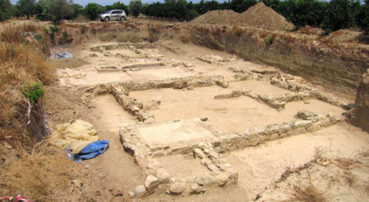
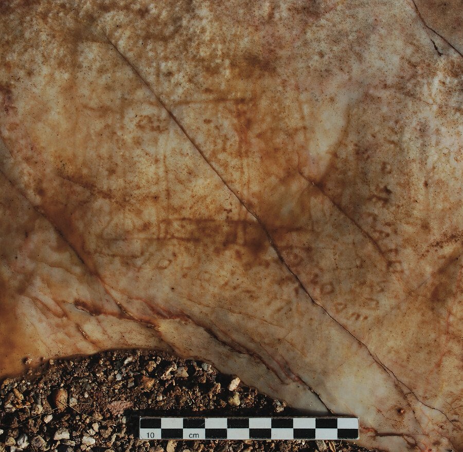
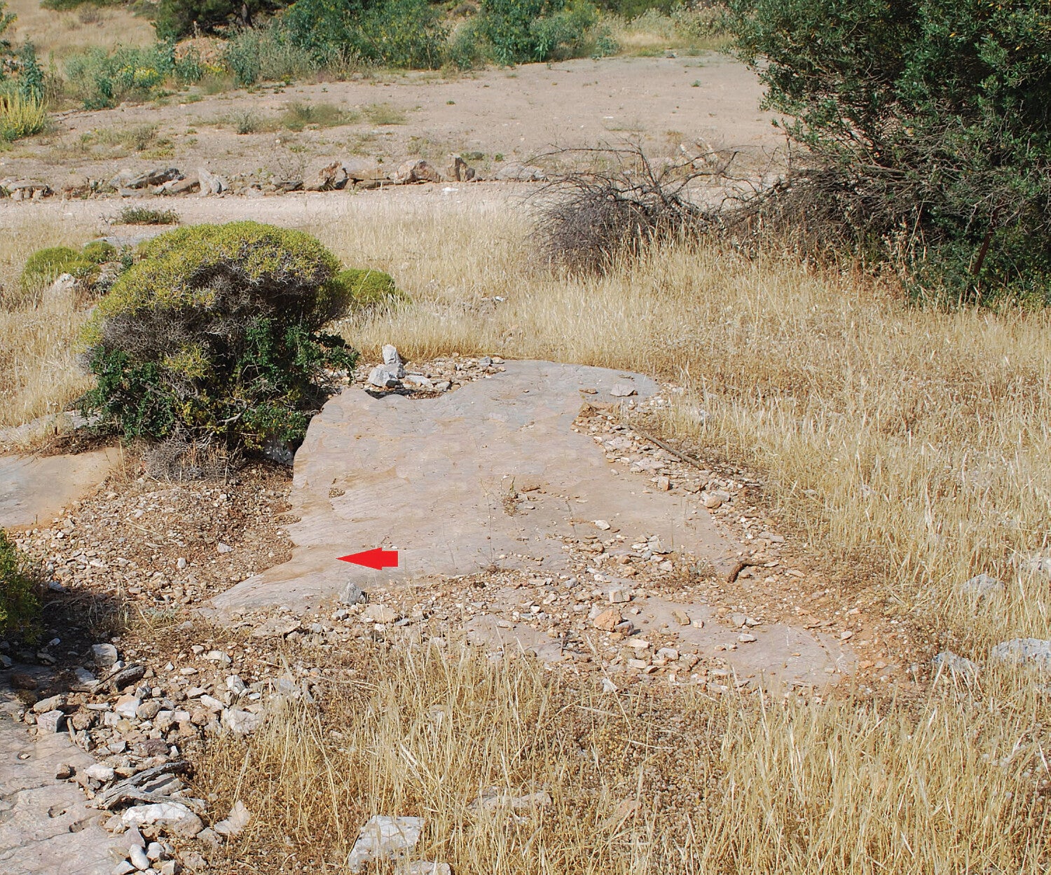
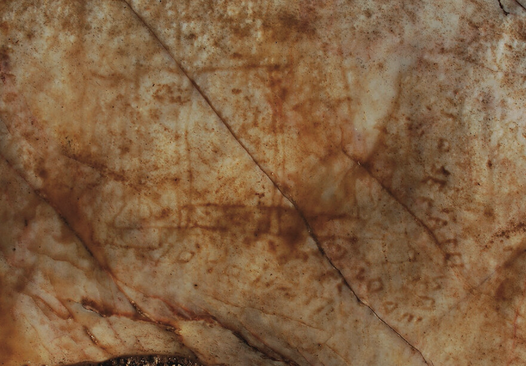
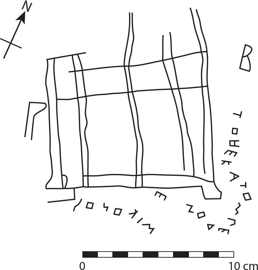
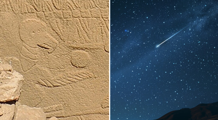
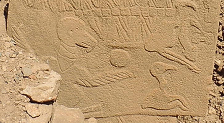
Researchers have uncovered unique graffiti on Barako Hill near Vari, Attica that may indicate there once stood a massive ancient Greek temple or structure on Athen’s famous Acropolis that has since been lost to history.
According to a new study published in the American Journal of Archaeology, this ancient drawing, attributed to a shepherd named Mikon, depicts a building identified as “the Hekatompedon,” a term historically associated with large temples.
“Mikon is not otherwise known, but he was most likely a shepherd who made the graffito while grazing his flocks,” explained Janric van Rookhuijzen, an archaeologist and co-author of the study, ina recent article. “The version of the Greek alphabet used is very ancient, making it clear that the drawing was made as early as the 6th century BCE.”
An image of Mikon’s graffiti showing a possible ancient temple. (Image: MERLE K. LANGDON & JAN Z. VAN ROOKHUIJZEN, AMERICAN JOURNAL OF ARCHAEOLOGY 2024)
The graffito (a term sometimes used to describe a singular piece of graffiti) was found among over 2,000 ancient engravings on marble outcrops in the hills north and east of Vari. These engravings, typically created by local herders, include simple drawings of animals, ships, and buildings, as well as short inscriptions. The particular graffito in question looks like a building facade, showing at least five columns, and is accompanied by an inscription identifying it as “the Hekatompedon.”
The term “Hekatompedon” refers to a structure approximately 100 feet in length. In ancient Greek architecture, this term was often used to describe large temples. But, it also means something else.
Patch of bedrock where the graffito is located (arrow); the earthen road is visible in the background
(American Journal of Archaeology/Langdon et al)
Photograph of the graffiti
(American Journal of Archaeology/Langdon et al)
Sketch of the graffiti, indicating reasonably secure lines and letters
(American Journal of Archaeology/Langdon et al)
“The term is known to be the official ancient name of the famous temple dedicated to the Greek goddess Athena – later known as the Parthenon,” van Rookhuijzen explained. “It is likely that Mikon wanted to depict a building on the Acropolis of Athens.”
However, the inscriber, Mikon, pre-dated the Parthenon by several decades.
“Because the alphabet he used can be firmly dated to the 6th century BCE, the drawing must be at least 50 years older than the Parthenon, which was begun around 450 BCE,” van Rookhuijzen wrote.
According to the researchers, they believe that the graffito likely depicts an archaic temple on the Acropolis of Athens, possibly the so-called Bluebeard Temple or the Gigantomachy Temple. These temples are thought to have stood on the Acropolis at the end of the sixth century BCE, but were destroyed by the Persians in 480 BCE.
The Acropolis of Athens.
(Image: Unsplash)
Utilizing high-resolution photographs and detailed sketches, the work of this long-dead shepherd was analyzed for the various letter forms, orthography, and layout to determine its authenticity. The team compared this drawing and writing style to other known examples, as well as other known architectural drawings and inscriptions from the area.
Based on their research, they note this is the earliest written record of the term “Hekatompedon” being used to describe a large temple or building. Moreover, noting the style of the graffito, as it features lines for columns and a cross line that represents an entablature (the horizontal lintel that sits on top of the columns), the study argues that this was probably some kind of symbolic gesture of admiration for the temple.
In simple terms, Mikon probably just dug big buildings, and shepherds and herders were notorious for their graffiti. The hill where this drawing was discovered is covered in ancient shepherd graffiti, including images of horses, boats, and, of course, ancient erotica.
“Why the shepherds produced so many graffiti is not known – it may have simply been a form of escapism during the dull moments of their job,” van Rookhuijzen mused.
“However, the graffito made by Mikon shows how a small scribble may be the key to tackling the historical riddles behind one the world’s most iconic archaeological sites.”
MJ Banias covers space, security, and technology with The Debrief. You can email him at mj@thedebrief.org or follow him on Twitter @mjbanias.
The British Museum - Takori234/Wikimedia commons - CC BY-SA 4.0
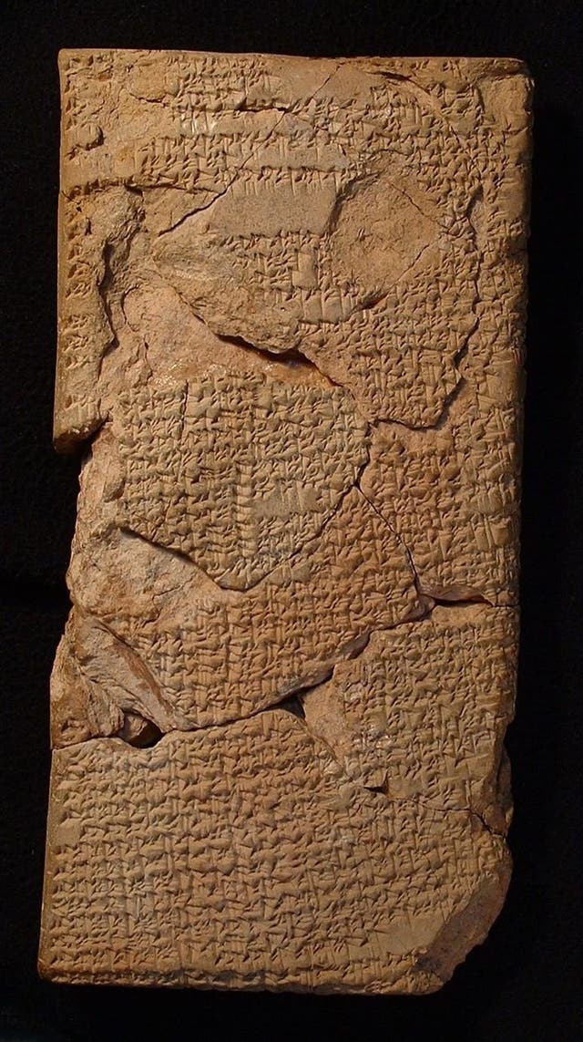
Deskundigen zijn er eindelijk in geslaagd enkele zeer oude Babylonische tabletten te ontcijferen, maar wat ze zeggen is helemaal niet geruststellend. Laten we er meer over te weten komen.
De betekenis van oude Babylonische tabletten ontdekt
Meer dan honderd jaar geleden werden Babylonische tabletten met spijkerschrift van 4000 jaar oud ontdekt. Ze worden momenteel bewaard in het British Museum in Londen, Engeland, maar zijn in al die tijd nooit ontcijferd. Tenminste, tot vandaag.
Wetenschappers hebben eindelijk wat licht geworpen op hun betekenis, maar het nieuws is verre van geruststellend. Blijkbaar bevatten de tabletten informatie over maansverduisteringen, waarvan sommige zijn geïnterpreteerd als voortekenen van belangrijke negatieve gebeurtenissen voor de mensheid. Andrew George, Babylonisch docent aan de Universiteit van Londen, en onderzoeker Junko Taniguchi, leggen in hun studie uit dat de vier kleitabletten "de oudste voorbeelden vertegenwoordigen van compendiums van voortekenen van maansverduisteringen die tot nu toe zijn ontdekt.
Babylonische tabletten, voortekenen gebaseerd op maansverduisteringen
The British Museum
Volgens de auteurs van het onderzoek berekenden degenen die de tabletten hebben gemaakt de nachttijd, de beweging van de schaduwen, de datum en de duur van maansverduisteringen om hun voortekenen te formuleren. Op basis van bepaalde kenmerken van eclipsen voorspelden de oude Babyloniërs de gevolgen ervan. Een van de voortekenen verwijst bijvoorbeeld naar het feit dat als de zonsverduistering “in één keer vanuit het midden donker wordt en in één keer licht wordt”, dit ongeluk zou betekenen voor de koning en de stad Elam, een regio in Mesopotamië waar Iran zich vandaag bevindt.
Als de zonsverduistering in het zuiden zou beginnen en vervolgens opklaarde, spreekt de voorspelling over de “val van Subartu en Akkad”, twee andere gebieden in het oude Mesopotamië. Andere negatieve gebeurtenissen werden verwacht in het geval van een zonsverduistering gedurende de avond. Waarschijnlijk baseerden astrologen uit die tijd hun voorspellingen op eerdere gebeurtenissen, die al hadden plaatsgevonden na maansverduisteringen.
Hemelse gebeurtenissen en voorspellingen in het oude Mesopotamië
Volgens Andrew George zouden de voortekenen in feite afkomstig kunnen zijn van gebeurtenissen die daadwerkelijk hebben plaatsgevonden, ook al waren de meeste voorspellingen naar alle waarschijnlijkheid geformuleerd door de eigenaardigheden van de eclipsen op een volledig theoretische manier met de verschillende voortekenen te associëren. In het oude Babylon geloofde men namelijk dat kosmische gebeurtenissen de toekomst konden voorspellen. De studie zegt dat, volgens mensen uit die tijd, “gebeurtenissen in de lucht gecodeerde signalen waren die daar door de goden waren geplaatst als waarschuwingen over de toekomstperspectieven van degenen die op aarde leefden. Zij die de koning raad gaven, hielden de nachtelijke hemel in de gaten en vergeleken hun waarnemingen met het academische corpus van teksten over hemelse voortekenen".
Aangenomen wordt dat de tabletten afkomstig zijn uit Sippar, het huidige Irak. Toen ze 4000 jaar geleden werden gemaakt en geschreven, breidde het Babylonische rijk zich uit naar verschillende gebieden van Mesopotamië. Tussen 1982 en 1914 werden ze onderdeel van de collectie van het British Museum, maar pas nu zijn ze voor het eerst ontcijferd.
Mystery over Stonehenge origins deepens after 'jaw-dropping' discovery
Mystery of Stonehenge deepens after ‘jaw-dropping’ discovery
Stonehenge. Picture: Alamy
By Emma Soteriou
The mystery over Stonehenge's origins has deepened after a "jaw-dropping" discovery.
Most of the monument's bluestones were sourced from the Preseli Hills in Wales - around 150 miles from the site.
But fresh research suggests the largest Altar Stone at the heart of Stonehenge is actually Scottish.
The "remarkable" discovery has left experts "stunned" and busts a century-long held belief about the origins of the bluestone.
It is unclear when the stone arrived at the site on Salisbury Plain in Wiltshire, but the scientists say it may have been placed within the central horseshoe of stones during the second construction phase at about 2620-2480 BC.
The new discovery implies that one of the most famous stones in the world was moved much further than had been believed - at least 435 miles.
For the last century, the six-tonne sandstone was believed to have come from Wales, with the rest of the bluestones.
After work to examine the stone's chemical composition and mineral grains, scientists can say with 95% confidence that the sandstone is very likely to instead have come from north-east Scotland.
The study involved scientists at Aberystwyth University, University College London and, in Australia, Curtin University and the University of Adelaide.
The findings indicate a striking similarity between the Old Red Sandstone of the Orcadian Basin in north-east Scotland and the Stonehenge Altar Stone.
Stonehenge with winter solstice sunset. Picture: Alamy
Co-author Professor Richard Bevins, from Aberystwyth University, said: "These findings are truly remarkable - they overturn what had been thought for the past century.
"We have succeeded in working out, if you like, the age and chemical fingerprints of, perhaps, one of the most famous of stones in the world-renowned ancient monument.
"It's thrilling to know that our chemical analysis and dating work has finally unlocked this great mystery.
"We can now say that this iconic rock is Scottish and not Welsh.
"Although we can say that much, and confidently - the hunt will still very much be on to pin down where exactly in the north-east of Scotland the Altar Stone came from."
The scientists used their analysis of the ages of the mineral grains in the stone to create a fingerprint of the source of those grains.
They matched ages found in rocks of the Orcadian Basin found in the north-east of Scotland, and are completely different from Welsh-sourced stones.
Anthony Clarke, from the Timescales of Mineral Systems Group at Curtin University, in Perth, Western Australia, said: "Considering the technological constraints of the Neolithic, our findings raise fascinating questions about how such a massive stone was able to be transported over the vast distance implied.
"Given major overland barriers en route from north-east Scotland to Salisbury Plain, marine transport is one feasible option."
Commenting on the findings, he added: "All four of us were stunned. We couldn't believe it."
Co-author Dr Robert Ixer, of the UCL Institute of Archaeology, said: "This is a genuinely shocking result, but if plate tectonics and atomic physics are correct, then the Altar Stone is Scottish.
"The work prompts two important questions: why and exactly how was the Altar Stone transported from the very north of Scotland, a distance of more than 700 kilometres, to Stonehenge?"
The lost island of Atlantis may have been found 2km under the ocean
The lost island of Atlantis may have been found 2km under the ocean
(Picture: Getty)
The lost island of Atlantis may have been found 2km under the ocean Some people believe that in the Atlantic Ocean, lying west of the Strait of Gibraltar, lies the legendary island of Atlantis. The island itself is thought to have been created by the philosopher Plato. His tale of a fabled civilization that the Gods plunged into the ocean as a punishment for its citizens' pride and arrogance has survived thousands of years. And now researchers think they may have found Plato’s inspiration for such a legend. In an area north of the Canary Islands, Spain, scientists have uncovered a vast submerged mountain that likely sank off the coast of the islands millions of years ago
(Picture: IGME-CSIC)
The lost island of Atlantis may have been found 2km under the ocean The seamount, which has been dubbed as Mount Los Atlantes, has three inactive volcanoes each around 50km (30 miles) in diameter, with their bases over 2km under the ocean surface, according to researchers from Spain’s Geological and Mining Institute (CSIC). Some of the lost islands even, after all this time, still have their beaches intact. The team said that some of the beaches sit just 60m (200 feet) below the ocean's surface. During the last ice age, when sea levels were far lower than they are today, the inactive volcanoes would have become islands again, which could have been used to inhabit wildlife
(Picture: IGME-CSIC)
The lost island of Atlantis may have been found 2km under the ocean These volcanoes were once part of a system of islands that sat around the east of Lanzarote, off the coast of West Africa, during the Eocene era around 56 million years ago, CSIC said. Geologist and project coordinator Dr Luis Somoza told LiveScience: ‘This could be the origin of the Atlantis legend’ referring to the Ancient Greek philosopher’s tale. In a statement he said: ‘They were islands in the past and they have sunk, they are still sinking, as the legend of Atlantis tells. Some of us have been able to verify that they still maintain their beaches’
(Picture: IGME-CSIC)
The lost island of Atlantis may have been found 2km under the ocean The team of geologists went aboard the Sarmiento de Gamboa, an oceanographic vessel of the CSIC, and used an advanced remotely operated vehicle (ROV) to survey the waters at depths around 2.5km (1.5 miles) for a better understanding of the region’s volcanic activity. The dive was part of the team’s Atlantis project which aims to understand underwater volcanic and hydrothermal activity in the region
(Picture: IGME-CSIC)
The lost island of Atlantis may have been found 2km under the ocean They also assessed the state of the seabed around the archipelago from June 27 to August 6 to look for signs of magma and underwater volcanic activity that may pose risks to Spain’s population in the future. Some of the volcanoes in the underwater region may be more modern than previously thought, and could be the submarine equivalents of Spain’s Timanfaya volcano system, the team suggested
(Picture: IGME-CSIC)
The lost island of Atlantis may have been found 2km under the ocean The researchers also looked at how underwater minerals form in such extreme conditions as well as the water’s levels of microorganisms encouraging the formation of metals like manganese, cobalt, and phosphates, which are important for energy transition. The team will analyse the samples collected from Los Atlantes to date the volcanic rocks and pinpoint when the islands began to sink
(Picture: IGME-CSIC)
The lost island of Atlantis may have been found 2km under the ocean The study also reflects the vast life that exists on the seabed after the underwater lava flows formed the lava deltas, revealing how underwater life is reborn after the recent eruptions with new gardens of corals and sponges, or areas covered with bacterial next to the hydrothermal sources
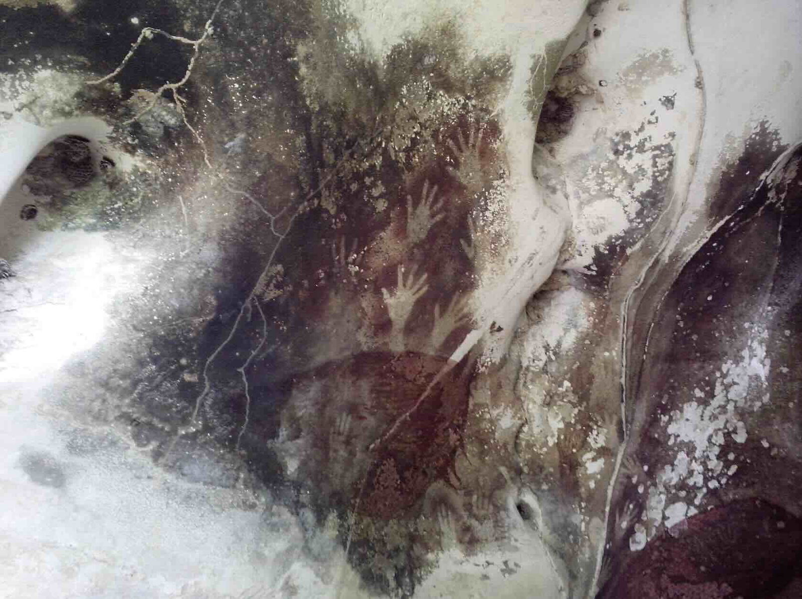
Waaruit is de beschaving ontstaan? Een studie heeft misschien het antwoord gevonden in Turkije: het lijkt erop dat alles begon na de inslag van een oude komeet.
Gravures op de archeologische vindplaats Göbekli Tepe
Archeologen onderzochten gravures op een Turkse vindplaats die naar schatting 7000 jaar ouder zijn dan de Grote Piramide van Gizeh. In een poging om ze te interpreteren kwamen ze tot de conclusie dat ze de inslag van een oude komeet op aarde zouden kunnen voorstellen. Concreet gaat het om de archeologische vindplaats Göbekli Tepe, waarvan experts denken dat het de oudste zonnekalender op onze planeet zou kunnen zijn. Dit 12.000 jaar oude monument is de meest gedateerde architectonische constructie gewijd aan aanbidding die ooit is ontdekt.
Op de tempelachtige omheiningen van de site zijn complexe symbolen gegraveerd. Het onderzoeksteam verklaarde dat deze naar alle waarschijnlijkheid een weergave zouden kunnen zijn van een kosmische gebeurtenis die een keerpunt vormde voor de menselijke beschaving. Als dat zo is, zou dat betekenen dat de oude mensen astronomische informatie gebruikten om een zonnekalender te maken die vergelijkbaar is met de kalender die duizenden jaren later door de Grieken werd uitgevonden.
De impact van de komeet en de lunisolaire kalender
Time and Mind
Martin Sweatman, scheikundig ingenieur aan de Universiteit van Edinburgh, Schotland, en eerste auteur van het onderzoek, zei: "Het lijkt erop dat de inwoners van Göbekli Tepe scherpe waarnemers van de hemel waren, wat te verwachten was gezien het feit dat hun wereld was verwoest door de inslag van een komeet."
Na een dergelijke gebeurtenis lijkt het erop dat de Ouden gegraveerde V-vormige symbolen gebruikten om de individuele dagen op hun kalender aan te geven: door het tellen van de gravures identificeerden de onderzoekers 365 dagen op een van de pilaren, verdeeld in twaalf maanmaanden en 11 extra dagen. Sommige vogelachtige figuren hebben een V op hun nek en zouden volgens de auteurs godheden kunnen voorstellen. Als de interpretaties kloppen, zou dit monument de oudste lunisolaire kalender worden die ooit is ontdekt.
Een komeet begon de beschaving 13.000 jaar geleden
Time and Mind
Maar wat weten we over de hemelse gebeurtenis die dit alles heeft veroorzaakt? Onderzoekers geloven dat het prehistorische monument is opgericht ter ere van de dag waarop fragmenten van een komeet 13.000 jaar geleden op de aarde neerstortten. In feite lijkt een van de pijlers van de site de meteorieten van de Tauriden af te beelden, waarvan de stroom de regen van fragmenten zou hebben veroorzaakt die 27 dagen duurde.
Zo'n inslag rond 10.850 voor Christus zou een kleine ijstijd kunnen hebben ingeluid over een periode van meer dan 1.200 jaar, wat zou hebben geleid tot het uitsterven van verschillende diersoorten. Paradoxaal genoeg maakte de komeet “ruimte” voor het ontstaan van een beschaving in de Vruchtbare Halve Maan in het Midden-Oosten, die de overgang markeerde van jagen en verzamelen naar landbouw. Bovendien behield het monument millennia lang een prominente rol in de cultus van de beschaving, wat mogelijk zelfs leidde tot het ontstaan van een nieuwe religie. Zoals Sweatman uitlegde, kan de inslag van de komeet “de beschaving hebben aangewakkerd, een nieuwe religie hebben doen ontstaan en de ontwikkeling van de landbouw hebben gestimuleerd om het koude klimaat het hoofd te kunnen bieden. Het is aannemelijk dat de pogingen van de Ouden om vast te leggen wat ze zagen, de eerste stappen waren in de richting van de ontwikkeling van het schrift duizenden jaren later."
There’s a special kitchen at the bottom of the sea. Scientists are now closer to reconstructing how it whipped up early life, thanks to a massive 1.2-kilometer core that a ship drilled out from a Mount-Rainier-sized underwater mountain in the Atlantic Ocean.
Johan Lissenberg, igneous petrologist at Cardiff University, and his colleagues are fascinated with the extreme temperatures of melted rock. Earth churns out molten rock, and seawater cools it down. It is intrinsic to the planet itself, and likely created life. The undersea mountain, called the Atlantis Massif, is home to a hot spring environment known as the Lost City hydrothermal field. Eons ago, a place like this may have been the cradle of unique microbes and the creatures that consumed them.
In a new study published Thursday in the journal Science, Lissenberg and a team of scientists analyzed the mantle rock the JOIDES Resolution research ship drilled out of Atlantis Massif last year. The trip was led by the International Ocean Discovery Program.
The remotely operated vehicle (ROV) Hercules approaches a ghostly, white, carbonate spire about 2,500 feet below the surface of the Atlantic Ocean, in the Lost City hydrothermal field of Atlantis Massif.
Atlantis Massif is one of the rare places on Earth where geochemists can get their hands on material from the largest part of our planet: the upper mantle.
“Say three to four billion years ago, the continental crust was formed from magma that was sourced in the mantle," Lissenberg tells Inverse.
“But the oceanic crust is always forming. Every day, basically,” he adds. As subaquatic tectonic plates spread apart, the melted rock that makes up Earth's mantle rises up. The material that reaches the surface forms new crust. So, the drill core is a snapshot of processes happening deep below the oceanic floor otherwise inaccessible to researchers.
“The rocks that were present on early Earth bear a closer resemblance to those we retrieved during this expedition than the more common rocks that make up our continents today,” Susan Lang, an associate scientist in Geology and Geophysics at the Woods Hole Oceanographic Institution and co-chief scientist on the expedition, said in a study announcement.
Enigmatic reactions
The ship’s sample is mantle rock, the residue of partial melting underneath Earth’s crust. Embedded within it are minerals that may have been key to understanding early life, like serpentine. This mineral gets its name from a resemblance to snake skin. It’s usually grayish, white or green in color. It occurs when the primary mineral in mantle rock, called olivine, reacts with seawater.
This process releases hydrogen. “Hydrogen can then make compounds such as methane, which can then underpin microbial communities,” Lissenberg says.
Going forward, Lissenberg really wants to understand those reactions. The new study is a start. As the team logged the details of the core centimeter by centimeter, they were surprised. Instead of being rather homogenous, they saw a variability in the mineral composition.
This matters when scientists reconstruct the “chemical kitchen,” Lissenberg says, that led to reactions supporting life. Ultimately, Lissenberg wants to understand all the “flavors” of the upper mantle.
Cicero Moraes et alii/Wikimedia commons - CC BY 4.0
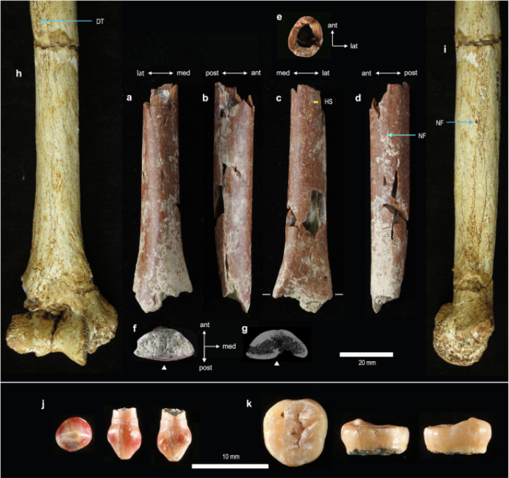
Er zijn nieuwe fossielen ontdekt van de Floresmens, een uitgestorven soort die net iets meer dan twee decennia bekend is en veel twijfels heeft opgewekt onder wetenschappers.
Floresmens, klein mens uit het verleden
Fossielen van de zogenaamde ‘hobbits’ die op Indonesisch grondgebied zijn gevonden, vertellen over minuscule mensen die 700.000 jaar geleden leefden. De nieuw ontdekte overblijfselen voegen informatie toe over hun twijfelachtige oorsprong: deze oude menselijke soort, die het eiland Flores bewoonde en ongeveer 50.000 jaar geleden uitstierf, heeft in feite voor veel verwarring onder wetenschappers gezorgd.
Homo floresiensis werd eenentwintig jaar geleden voor het eerst ontdekt en dit leidde tot twijfels over het oorspronkelijke idee dat de menselijke evolutie een lineair pad volgde, met een voortdurende ontwikkeling van primitieve wezens tot de moderne mens. De homo "hobbit", zo genoemd vanwege zijn kleine formaat, leefde echter in vrij recente tijden ondanks zijn kleine lichaam. Bovendien, hoe slaagde hij erin om de oceaan over te steken naar het Indonesische eiland, waar past hij in de stamboom van de mensheid en waarom is hij uitgestorven?
Homo hobbit, miniatuurversie van Homo erectus?
Nature Communications
De auteurs van een nieuwe studie probeerden deze twijfels weg te nemen door fossielen te onderzoeken die toebehoorden aan een van deze kleine mensen en die ontdekt zijn op de eindplek Mata Menge, een van de slechts twee plaatsen op het eiland Flores waar overblijfselen van deze soort zijn gevonden. De resultaten van het onderzoek, zo leggen de auteurs uit, bevestigen de al eerder geformuleerde hypothese, volgens welke hobbits een soort miniatuurversie zouden zijn geweest van Homo erectus, de eerste die Afrika 1,9 miljoen jaar geleden verliet. Fossielen van Homo erectus zijn gevonden in Azië, Afrika en op het eiland Java, in Indonesië. Volgens wetenschappers bereikten ze het eiland ongeveer een miljoen jaar geleden en hier nam de omvang ervan in de loop van 300.000 jaar drastisch af.
Hetzelfde proces komt ook voor bij andere dieren die op afgelegen eilanden leven, vanwege de beperkte beschikbaarheid van hulpbronnen. Yousuke Kaifu, eerste auteur van het onderzoek en professor aan de Universiteit van Tokio, legt uit: "Misschien was het niet nodig om een groot lichaam te hebben, dat meer voedsel nodig heeft en er langer over doet om te groeien en zich voort te planten. Het geïsoleerde eiland Flores had geen roofdieren van zoogdieren en andere hominide soorten, dus de kleine omvang was prima".
Daarom was de hobbit zo klein
De hobbit waartoe de fossielen behoorden was een volwassene van ongeveer 100 meter lang en de tanden leken sterk op die van de Homo erectus die op Java is gevonden. Een andere bekende Homo floresiensis, ontdekt in de grot Liang Bua in 2003, ongeveer 75 km van Mata Menge, was zes centimeter groter en ongeveer 60.000 jaar oud. Dit verschil in grootte zou kunnen worden toegeschreven aan het verschil dat bij de moderne mens is gevonden. Homo floresiensis heeft zijn kleine formaat echter lange tijd consistent behouden.
De vondsten suggereren dat deze kleine mensen op het eiland konden overleven en zich konden vermenigvuldigen, ondanks de aanwezigheid van krokodillen en Komodovaranen, waarvan de lengte 3 meter bedroeg. De auteurs schrijven dat "de eerste dramatische vermindering en de daaropvolgende stabiliteit in omvang erop wijzen dat het hebben van een kleinere lichaamsgrootte op dit eiland een overlevingsvoordeel was voor deze archaïsche mensen."
Naast de hobbit leidt de ontdekking van andere kleine mensen zoals Homo naledi uit Zuid-Afrika en Homo luzonensis uit de Filipijnen, maar ook de grotere Denisovamens uit Tibet, tot de conclusie dat er verschillende soorten mensen bestonden, waarvan vele uit de tijd van de onze, Homo sapiens, en dat geen enkele soort zich in de loop van de tijd heeft ontwikkeld. Hoe dan ook, niet alle experts zijn het eens over de oorsprong van de hobbits en hun geschiedenis moet nog definitief worden opgehelderd.
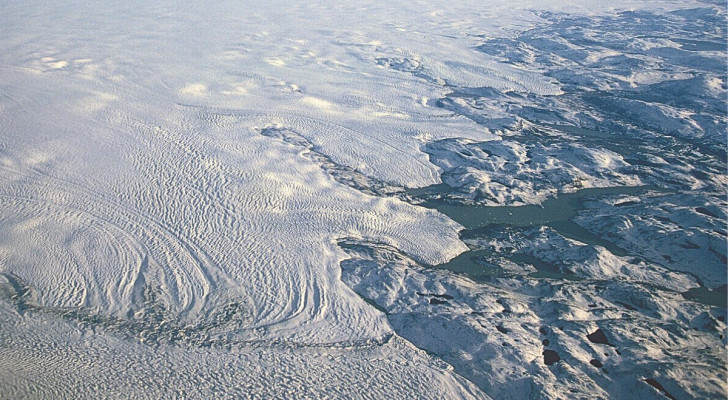
Het centrum van de Groenlandse ijskap is in een niet al te ver verleden gesmolten, zo blijkt uit een onderzoek: het onomstotelijke bewijs zijn fossielen die zijn gevonden in wat ooit een groene toendra was.
Ook het centrum van Groenland is in het verleden gesmolten
Tegenwoordig zien we Groenland als een witte ijsvlakte, maar ooit was dat helemaal niet zo. Voortdurende ontdekkingen over het verleden van dit ijzige gebied op aarde onthullen steeds meer ongelooflijke achtergronden, zoals het feit dat het er uitgesproken “groen” uitzag. Nieuw onderzoek heeft bewijs gevonden dat niet alleen de randen, maar ook het midden van de Groenlandse ijskap in een nog niet zo ver geologisch verleden is gesmolten en dat het “oude” landschap eruitzag als een toendra.
In 1993 werd een ijskern van meer dan 3 kilometer lang uit het centrale deel van het grondgebied gewonnen en vervolgens tot op de dag van vandaag bewaard in een afzetting in Colorado, VS. Nu heeft een groep wetenschappers opnieuw de sedimenten op de bodem van dit halfronde stuk ijs onderzocht en iets spannends ontdekt.
Fossielen in het midden van de ijskap
Halley Mastro/University of Vermont
Het team ontdekte dat de sedimenten schimmels, insectenresten, wilgenhout en een maanzaad bevatten, allemaal ongerept. Paul Bierman van de Universiteit van Vermont, co-auteur van het onderzoek samen met Halley Mastro, stelt: "Deze fossielen zijn prachtig."
Onderzoek heeft het feit bevestigd dat de enorme ijskap van Groenland in het verleden is gesmolten als gevolg van een bijzonder warme periode, waardoor een groen eiland is ontstaan. Aangenomen wordt dat dit in de afgelopen miljoen jaar heeft plaatsgevonden, wat betekent dat de ijskap veel kwetsbaarder is dan wetenschappers hadden gedacht. Sinds het ijs in het midden van Groenland smolt, spreekt het voor zich dat de rest van het eiland hetzelfde lot onderging en, volgens Bierman, duizenden jaren lang, genoeg om een terrein te creëren dat klaar was om een ecosysteem te huisvesten.
Richard Alley, klimatoloog aan de Pennsylvania State University, verklaarde na bestudering van de resultaten van het onderzoek: “Het bevestigt en breidt het feit uit dat een groot deel van de zeespiegelstijging plaatsvond in een periode waarin de oorzaken van de opwarming niet bijzonder extreem waren”, en ziet het als een waarschuwing voor wat er zou kunnen gebeuren als het klimaat verder opwarmt door toedoen van de mens.
GISP2 till and macrofossils found in it: (A) Photo of the angular-clast-rich till section of the GISP2 subglacial core, taken 1994, up core to left (Credit: T. Gow, supplied by D. Meese). (B) Overview of sediment, mostly quartz and fossils. (C) Wood fragment. (D) Vertical orientation typical of GISP2 wood. (E) Wood at higher magnification showing simple pits in lateral vessel wall (1) and distinct simple perforation plate (2), along with the helical thickening typical of GISP2 wood. (F) Bud scale of Salix (willow). (G) Sclerotium of the soil fungus C. geophilum* (H) Insect eye, possibly from a fly*. (I) S. rupestris megaspore. (J) Seed of Papaver sect. Scapiflora. The asterisk shows macrofossil types also found in Camp Century sediment by ref. 5. Wood fragment images are same specimen.
De “kwetsbaarheid” van Groenland bevestigd
In feite stijgt de zeespiegel met 2,5 cm per jaar en in een versnellend tempo. Tegen het einde van deze eeuw zullen de oceanen naar verwachting ongeveer zes meter hoger stijgen dan nu.
In 2016 werd dezelfde ijskern, GISP2 genaamd, onderzocht door wetenschappers van Columbia University: de resultaten suggereerden dat de huidige ijskap niet ouder kon zijn dan 1,1 miljoen jaar en dat Groenland tijdens het Pleistoceen lange tijd zonder ijs heeft gezeten, minstens 90% van zijn grondgebied. In 2019 werden in een andere ijskern, die in de jaren ’60 werd gedolven, kleine takken en gefossiliseerde insecten gevonden die 416.000 jaar oud waren. Het huidige onderzoek bevestigde dat dit bevroren eiland niet zo sterk en veerkrachtig is als eerder werd gedacht: meer dan 3 meter ijs smolt gemakkelijk, waardoor er tijd en ruimte overbleef voor de ontwikkeling van een toendra.
Zealandia: het achtste continent dat onder de oceaan verborgen is
Zealandia: het achtste continent dat onder de oceaan verborgen is
Artikel door thedailydigest.com
Een achtste continent onder water
Wetenschappers uit Australië en Nieuw-Zeeland hebben onlangs een nieuw onderwatercontinent herontdekt, namelijk Zealandia.
Afbeelding: NEOM/Unsplash
Een groep eilanden
Het is in feite een groep eilanden die vergelijkbaar is met de eilanden waaruit Nieuw-Zeeland bestaat, met een oppervlak dat iets minder groot is dan de helft van Brazilië.
Afbeelding: Marjan Blan/Unsplash
Een oud supercontinent Er wordt aangenomen dat Zealandia deel uitmaakte van het oude supercontinent Gondwana, dat enkele honderden miljoenen jaren geleden een groot deel van het zuidelijk halfrond van onze planeet bedekte.
Afbeelding: Benjamin L. Jones/Unsplash
Indrukwekkende afmetingen Volgens een artikel van de BBC zijn de afmetingen van dit ondergedompelde continent indrukwekkend: 4,9 miljoen vierkante kilometer.
Afbeelding: Jean Beller/Unsplash
De grootte van India Volgens een ander team onderzoekers, dat in 2017 het continent Zealandia voor het eerst claimde te hebben ontdekt, heeft het ongeveer dezelfde grootte als India, zo bericht Ouest France.
Afbeelding: Greg Rosenke/Unsplash
Bijna het gehele oppervlak bevindt zich onder water Het land van Zealandia maakte waarschijnlijk deel uit van een uitgestrekt gebied boven zeeniveau. Tegenwoordig bevindt 94% van het oppervlak zich echter onder water.
Afbeelding: Yannis Papanastasopoulos / Unsplash
Wat is het precies? Gaat het om een groot eiland of een continent? Zoals de Times of India opmerkt, is er geen geologische parameter die een precieze grens tussen de ene of de andere term vastlegt, en maakt het daardoor onderwerp voor discussie.
Afbeelding: Jay Wennington / Unsplash
Afgezonderd van het Australische continent Ondanks de nabijheid van Australië geloven wetenschappers dat de twee groepen afzonderlijk van elkaar bestaan. Al wordt de term 'Australazië' soms gebruikt om het volledige landgebied van het zuidwesten van de Grote Oceaan aan te duiden.
Afbeelding: Alex Rose / Unsplash
Gedetailleerde kartering Geowetenschappers hebben Zeelandia gedetailleerd in kaart gebracht, waarmee ook de locatie van vulkanische activiteit werd onthuld en belangrijke informatie over de opbouw van het continent werd verkregen.
Afbeelding: NOAA / Unsplash
Monsters genomen van de bodem in de oceaan Om deze kartering uit te voeren, verzamelden de onderzoekers geologische monsters van de landmassa die zich onder water in de oceaan bevindt.
Afbeelding: Tyler Lastovich / Unsplash
Een schat aan mineralen Het tijdschrift Slate berichtte dat er een echte schat is aangetroffen: "Een mengsel van verschillende soorten zandsteen, basalt en kalksteen".
Afbeelding: Christian Wiediger / Unsplash
Magnetische afwijkingen De datering van deze monsters en het onderzoek van hun magnetische afwijkingen stelden wetenschappers in staat om de Zealandia op een waardevolle manier in kaart te brengen.
Afbeelding: Matt Hardy / Unsplash
Waarom ligt Zeelandia onder water? De meest voor de hand liggende verklaring hiervoor is dat de tektonische platen door het uitrekken van Gondwana braken, waardoor het oceaanwater vrij spel kreeg.
Afbeelding: Dan Stark / Unsplash
Een dunne, ondergedompelde aardkorst Het loskomen van Antarctica zou de aardkorst van Zeelandia geleidelijk hebben verdund tot het land volledig was ondergedompeld.
Afbeelding: Dan Gold / Unsplash
Meer kennis over de eigenschappen van de aardkorst De ontdekkingen in Zealandia zouden wetenschappers meer kennis kunnen geven in waarom de aardkorst zo dun werd en zo sterk uitrekte.
Afbeelding: Matteo Paganelli / Unsplash
Zijn er nog andere verborgen continenten? We weten niet of er meer onderzeese continenten zijn, omdat we eigenlijk maar weinig weten over de diepten van de oceanen. De ruige omgeving bemoeilijkt dit soort plekken. Daarom is deze recente ontdekking zo waardevol!
A potentially revolutionary new technology that could greatly advance optical communications, surveillance, and photonic device isolation has something in common with the most captivating construction design of the ancient world: the pyramid.
Researchers at UCLA have produced a revolutionary new design for diffractive deep neural networks, or D2NNs, that they say significantly enhances unidirectional image magnification and demagnification. Dubbed Pyramid D2NNs, the new design architecture lives up to its name by introducing a pyramid-structured network that offers high-fidelity image formation while reducing refractive features, all by aligning its layers in the same direction of image magnification and demagnification.
What Are Diffractive Deep Neural Networks?
D2NNs are constructed from individual transmissive layers that are optimized through deep learning, allowing them to perform computation almost entirely through the use of optics.
In their recent research, the UCLA team, led by Professor Aydogan Ozcan, worked with a pyramid-shaped diffractive optical network, a design that allowed the team to achieve unidirectional imaging with fewer diffractive degrees of freedom.
The result is a design that helps to ensure high-fidelity image formation, but only in one direction. By contrast, significant image inhibition occurs in the opposite direction, conditions that are key for use with applications where imaging in one direction (i.e., unidirectional imaging) is required. Such fields include defense and security technologies, telecommunications applications, and systems used for privacy protection.
Artist’s concept of the pyramid diffractive optical network designed by Ozcan and his colleagues at UCLA
(Credit: Ozcan Lab / UCLA).
The team was also able to demonstrate modularity and scalability for their novel pyramid-structured system by cascading several P-D2NN modules. This allowed them to achieve even greater magnification or demagnification factors.
The Pyramid Mystery
The pyramid shape has long captivated human minds, and there is arguably no better example of this than the enigmatic pyramids at Giza.
In simple terms, a pyramid is a three-dimensional shape resulting from the construction of triangular faces arising from a polygonal base. Each of the points of the triangular portions meets at the highest point or apex.
This gives rise to a unique shape where weight is evenly distributed, which allowed ancient architects to rely on this design for the construction of some of the largest structures ever built, with the most famous examples comprising the Giza pyramids, monuments that are still impressive by today’s engineering standards, and which have proven their resilience by persisting for thousands of years. Given their enigmatic appearance, the pyramids have also contributed to a number of fringe ideas over the years, involving the mysterious powers the monuments at Giza may possess themselves or purported technologies (many of them pseudoscientific) based on the pyramid shape and powers it allegedly possesses.
The famous pyramids at Giza
(Credit: Osama Elsayed/Unsplash).
For the UCLA team, the pyramid structure offered real-life advantages in that the ascending structure allowed them to scale the layers of the new D2NN in such a way that aligns with the direction of image magnification or demagnification. In other words, the pyramid shape offers a sort of guide that either enlarges or shrinks the image in question in a controlled manner. The result is that high-fidelity imagery is able to pass progress through the network, but only in the desired direction.
During their research, the team also succeeded in experimentally validating the new P-D2NN system by using terahertz (THz) illumination. 3D-printed diffractive layers were tested under continuous-wave THz illumination, producing results that the team says very closely matched earlier numerical simulations.
Applications and Future Prospects
The system is ideal for various applications, including technologies that provide optical isolation for photonic devices and decoupling of transmitters and receivers in telecommunications. In the coming years, the new pyramid-shaped system could also benefit security and even surveillance technologies.
Overall, the team’s P-D2NN architecture represents a considerable advancement in optical imaging technology, which its developers believe could help pave the way toward a range of future innovations and applications. All of which, of course, relies on one of the most iconic and captivating ancient monumental shapes in human history.
The team’s findings were published in the journal Light: Science & Applications on July 31, 2024.
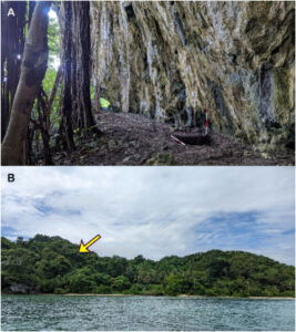
Newly discovered evidence suggests that 42,000 years ago, ancient humans likely used various forms of maritime capabilities, an advanced form of technology for the period in which it was used, to traverse the world’s oceans.
In Southeast Asia, new evidencs points to the use of watercraft that allowed ancient sailors to colonize a portion of the more than 13,000 islands that make up modern day Indonesia, including the remote Tanimbar Islands.
“The question of how our early ancestors arrived there from Southeast Asia is one of the most captivating in prehistoric migration, mainly because of the vast distances covered and advanced seafaring skills that would have been required,” explained Mr. Hendri Kaharudin, a PhD candidate at the Australian National University (ANU) and the lead author of the study outlining the advanced maritime technologies employed by these early sailors that helped them reach the Tanimbar Island of Elivavan.
“This discovery marks one of the southern route’s earliest known sites, making it a crucial piece of the puzzle,” Mr. Kaharudin added.
42,000 Years Ago, the First Human Migrants Sailed to Tanimbar
While scientists have often theorized about the first arrival of human migrants in Indonesia from Southeast Asia, no concrete theory is universally accepted. According to the team’s research published in Quarternary Science Reviews, recent discoveries made on the Indonesian Tanimbar island of Elivavan revealed that people first arrived there around 42,000 years ago.
“Along with tiny fragments of pottery, we also found evidence of things like bones, shells, and sea urchins that point to the island’s role as a hub for early maritime activities,” Mr. Kaharudin said.
A) View of Elivavan rock shelter and the test pit location; B) The location of Elivavan rock shelter (yellow arrow) seen from the narrow strait between Fordata and Larat islands. Image Credit: Kaharudin, et. al.
To reach this remote location, ancient mariners would have had to traverse exceedingly long distances over treacherous seas. Mr. Kaharudin said these ancient mariners would have had to traverse bodies of water over 100 kilometers in the distance “regardless of their direction of travel.” According to the press release announcing the new findings, “the risky nature of the sea crossings suggests the colonists had developed advanced maritime technology by around 42,000 years ago.”
If the discoveries made on Elivavan ultimately confirm the first route to Indonesia taken by ancient mariners over 42,000 years ago was a southern one, it will solve a long-standing debate between scientists about which route these original colonists took to get there.
“There are two main routes that have been explored as possibilities since the mid-20th century, a northern path via islands like Sulawesi, and a southern track passing near Timor and the Tanimbar islands,” Kaharudin explained. This particular location, which lies along the southern route, is significant, the researcher notes, as “Tanimbar is located just off the ‘Sahul shelf’, which encompasses modern-day Australia, as well as New Guinea.”
Map of Wallacea, delineating Birdsell’s northern and southern migration routes. The map also highlights the oldest Pleistocene sites on each island. Along the northern route, the following sites are indicated: 1) Leang Karampuang, Leang Tedongnge, and Leang Bulu Sipong 4, 2) Goa Topogaro, 3) Leang Sarru, 4) Daeo 2, 5) Golo, and 6) Kelo 6. On the southern route, the following sites are highlighted: 7) Liang Bua, 8) Lua Meko, 9) Makpan, 10) Laili, 11) Asitau Kuru, Lene Hara, Matja Kuru 2, 12) Here Sorot Entapa, and 13) Elivavan. The last two sites represent connections to Sahul: 14) Leang Lemdubu, currently in the Aru Islands but once connected to the mainland during the Pleistocene, and 15) Madjedbebe, the oldest known site in Sahul. Image Credit: Kaharudin et. al.
To make such a dangerous crossing, the researchers believe that these ancient seafaring humans likely hopped along the coasts, moving from island to island as they slowly spread out. This strategy evolved over time, the researchers note, meaning that the colonization was not a single event but “a gradual process involving successive waves of seafaring populations.”
“Coastal communities likely navigated shorelines, exploiting marine resources and establishing resilient settlements along their journey,” Mr. Kaharudin explained. “This island-hopping strategy facilitated cultural exchange and adaptation, shaping diverse societies across the land mass.”
Studying Remote Locations Could Uncover More About Ancient Human Life
Although the discovery of human occupation on Elivavan of the Tanimbar Islands over 42,000 years ago is significant, the researchers behind the discovery note that there is still much more work to be done. This includes taking a closer look at the area where these discoveries were made to paint a more complete picture of these early seafaring humans. In fact, according to Kaharudin, it is the exploration of these remote locations that could answer the mysteries of ancient human migration.
“As more work is done in lesser-explored regions like the Tanimbar Islands, I expect we’ll uncover more about early human life and migration patterns,” he explained.
Christopher Plain is a Science Fiction and Fantasy novelist and Head Science Writer at The Debrief. Follow and connect with him onX,learn about his books atplainfiction.com, or email him directly atchristopher@thedebrief.org.
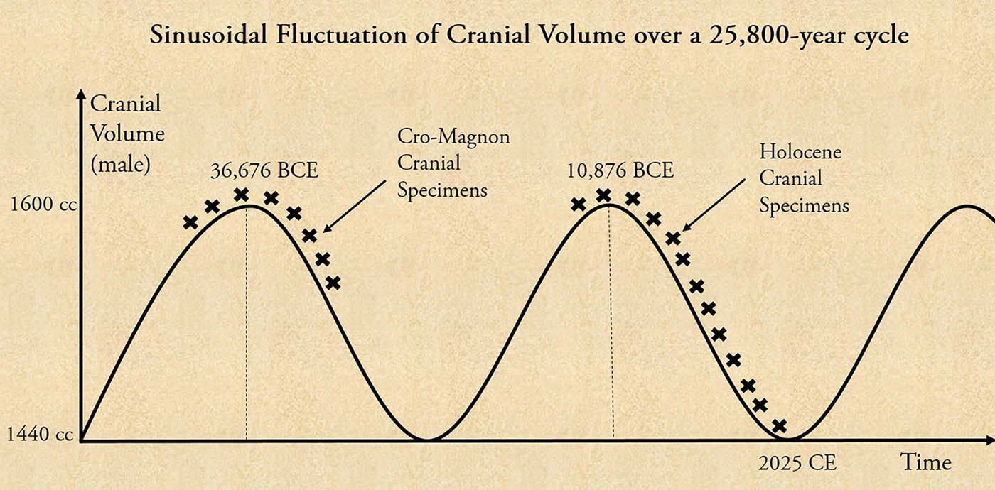
The Shocking Decline in Human Cranial Capacity: How do Evolutionists Explain it? They Don’t!
The Shocking Decline in Human Cranial Capacity: How do Evolutionists Explain it? They Don’t!
Bibhu Dev Misra
One of the stories that most of us have grown up hearing is that the human species is continuously evolving to higher levels of intellect, through a gradual process of evolution by natural selection. It has been drilled into us that the modern human species i.e. Homo sapiens, has evolved over millions of years from ape-like ancestors. The fundamental physical factor that drove the process of evolution was the increase in brain volume or cranial capacity, which, over time, led to a slew of innovations such as fire, tools, weapons, clothes, boats, shelter, burials, rock art, music, language, etc. The cranial capacity is regarded as the most important indicator of IQ, since many studies using Magnetic Resonance Imaging (MRI) of the brain in individuals who were tested for IQ, found significant correlations between the size of cerebral structures and measures of intelligence.
Now, if this story were true, then even in the modern day we should have found that our cranial capacities are gradually increasing over time. Instead, dozens of elaborate studies have revealed the exact opposite! The human brain has been consistently shrinking in volume over the past 12,000-odd years, since the end of the last Ice Age. We are dumber today than any time before in the Holocene era!
In one of the early studies titled, “Decrease of Human Skull Size in the Holocene”, published in the Human Biology journal in 1988, scientists computed cranial capacity (CC) for nearly 9500 male crania and 3300 female crania, originating from Europe and North Africa. The study found,
“Among male samples the peak CC (cranial capacity) occurred in the Mesolithic (1593 cc), the lowest value falls in modern times (1436 cc); in females sample timing is the same: Mesolithic maximum of 1502 cc and modern minimum of 1241 cc. For both males and females the decrease through time is smooth, statistically significant and inversely exponential. A decrease of 157 cc (9.9 % of the larger value) in males and of 261 cc (17.4 %) in females is a considerable one, of the order of magnitude comparable to the difference between averages for H. Erectus and H. Sapiens.”[1]
Separate studies conducted on large samples from Europe, the Near East, Africa, Japan and Australia have confirmed this general trend. Human cranial capacity has decreased by approx. 10% of its average value (i.e. 100-150 cc) since the Late Pleistocene until the early 20th century.[2]
If evolution by natural selection is consistently making us smarter then why did we lose such a large chunk of brain volume at a time when, supposedly, for the first time, humans transitioned from a hunter-gatherer lifestyle to settled, agricultural communities that allowed the first great civilizations of the world to flourish?
One of the first recognizable members of the genus Homo is called Homo erectus (meaning “upright man”), whose earliest appearance in the fossil records occurred around 2 million years ago. Homo erectus is thought to have been the earliest human ancestor capable of using fires, hunting and gathering in coordinated groups, caring for injured or sick group members, seafaring, and possibly art-making. The difference between the average cranial volume of Homo erectus and Homo sapiens is roughly the same as the amount of cranial volume that has been lost in the past 12,000 years in the Holocene period.
Allow that to sink in. In just 12,000 years, we have lost the same amount of intelligence that, purportedly, took nearly 2 million years to develop! How does that happen? And why has the cranial volume been declining at a time when the most significant advancements in human civilization supposedly took place?
Clearly, something is amiss here. The data does not lie. Certain unfounded assumptions appears to have been made about human evolution and the origins of civilization that does not accord with the precipitous decline in human cranial capacity during the Holocene period. One of the thoughts that struck my mind when I came across this stunning data is, how do evolutionists and anthropologists explain it?
I had a hard time finding a well-written paper or article on this topic until I came across this piece in the Discover Magazine titled, “If Modern Humans Are So Smart, Why Are Our Brains Shrinking?”[3], in which, science writer Kathleen McAuliffe, tells us that she was utterly dismayed when anthropologist John Hawks of the University of Wisconsin told her that, over the past 20,000 years, the average volume of the human male brain has decreased from 1,500 cc to 1350 cc, losing a chunk the size of a tennis ball. “This happened in China, Europe, Africa - everywhere we look,” Hawks informed her.
When Kathleen contacted other experts to find out if they knew about the shrinking human brain, she came to a startling realization. It was a closely guarded secret. “Only a tight-knit circle of paleontologists seem to be in on the secret, and even they seem a bit muddled about the matter,” she wrote to her utter surprise.
One of the experts she consulted was Christopher Stringer, a paleoanthropologist at the Natural History Museum in London. Stringer told her something quite stunning: “Scientists haven’t given the matter the attention it deserves. Many ignore it or consider it an insignificant detail”. I could hardly believe this. This absolutely jaw-dropping piece of scientific data, which turns the Darwinian theory of gradual evolution by natural selection on its head, is treated by some scientists as an “insignificant detail”. What really is significant then? How the Homo erectus learned to pick his nose?
Besides, why is there so much secrecy around this information? Why is it that only a “tight-knit circle of paleontologists” knows about this, and everyone else seems to be in the dark? Isn’t it the duty of scientists, academia and the media to widely disseminate this kind of shocking information and invite debates and discussions over it?
The truth is that, and many have written about it, scientists and academics do not earn any brownie points by ruffling the calm surface of “Lake Consensus”, as John Anthony West put it. There is a strong tendency to adhere to the status quo, and very often, errant academics who do not toe the official line, are put in their place by being denied grants, positions and other academic privileges. As a result, even if grave anomalies are observed in a theory that has achieved consensus, they are ignored or quietly filed away from the public eye. This kind of knowledge filtering goes on continuously, and what we know as the truth is simply a “consensus”, and nothing more.
Kathleen went on to write that, some scientists have tried to explain why our brains are shrinking, but their explanations are vague, muddled and inconsistent. According to Christopher Stringer, the reduction in cranial volume may be due to the decline in human stature since the Holocene period, since a larger brain is required to control a bigger body mass. However, John Hawks has contested this, claiming that the brain has shrunk much faster than the body. “For a brain as small as that found in the average European male today, the body would have to shrink to the size of a pygmy”, Hawks said. Besides, the scientific data indicates that human height declined till the end of the Bronze Age, after which it has been steadily increasing. But, brain volume has continued to decline till the modern period. This means there cannot be any cause-effect relationship between body size and brain size.
Cognitive scientist David Geary of the University of Missouri believes that people actually became dumber in the Holocene period. According to him, as population density increased and complex societies emerged, people did not have to be as smart to survive; they could get by with the help of others. This created the selection pressure for the brain to become smaller. However, historical facts do not support his contention. It is only around c. 5000 BCE in the Eastern Mediterranean that we see a jump in population densities, followed by the emergence of complex Bronze Age societies. In many other parts of the world, complex societies arose even later than that. By that time, there had already been a substantial reduction in cranial volume. What this implies is that, only after humans became substantially stupid they began to form large, complex societies, and, as a result, some people were able to get by without possessing any specific skill or sufficient gray matter.
John Hawks put a different twist on the situation. He believes that humans may be getting smarter due to a re-wiring of the brain. The brain is an energy guzzler; it consumes nearly 20 percent of our calorie intake. A bigger brain uses up more energy. So, optimally, we need a brain that packs the most intelligence for the least energy. Hawks believes that, over the past 10,000 years, due to a series of advantageous brain-related mutations, the neural connections of the brain may have become streamlined and the molecular activity at the synapses improved, thereby making us more intelligent than our Paleolithic ancestors, even though we have smaller brains.
So, what Hawks is essentially saying is that, after moving in the wrong direction for nearly 2 million years, turning itself into an energy-guzzling SUV, the brain went through a sudden awakening at the end of the last Ice Age and decided to change course and transform itself into a Tesla. Hawks himself admits that such a course correction would require a large number of very rare, beneficial mutations, the chances of which are extremely slim. The fact is that random new mutations are more likely to reduce than to raise intelligence. A course correction for the human brain after 2 million years of evolution in the wrong direction, due to the sudden appearance of extremely rare beneficial mutations, is wishful thinking at best.
Besides, there is no tangible evidence that the neural connections in the brain suddenly became more efficient after the onset of the Holocene Period. Nor is it likely that any such evidence will ever be found since brain tissue is not preserved for such long periods of time. If they were, we might have found that even the neural connections have degraded!
The truth is very simple. Our declining cranial capacity indicates that we have been getting dumber over the course of the past 12,000 years. Our memories have declined substantially compared to our ancestors who could remember massive volumes of data, and transmit them orally to the next generation. Our powers of judgment and discrimination have declined because of which we cannot distinguish between the truth and lies, or discern what truly serves our welfare as opposed to what takes us down the path of misery. Our ethics and morality have nosedived, along with all the subtle abilities of the brain that we possessed in the bygone ages such as intuition, telepathy, clairvoyance, etc.
Unfortunately, most people have been brought up to believe otherwise. They think that we are the smartest generation of people that ever lived since that is the idea that is pushed down their throats from an early age. The problem is, once people have been indoctrinated with a specific belief or ideology, no amount of evidence is enough to overturn that. The hardest things to get rid of are deeply held biases, and scientists are no exceptions to this.
Although the decline in cranial capacity during the Holocene period is at odds with Darwinian evolution, it is perfectly aligned with the doctrine of the Yuga Cycle or Great Year. The last 12,000 years comprise the descending arc of the Yuga Cycle, when human consciousness, memory and intelligence are supposed be in a state of continuous degradation. In the Mahabharata, the sage Markandeya told Yudhisthira, “Know, O Yudhisthira, that the period of life, the energy, intellect and the physical strength of men decrease in every Yuga!”[4] These statements, which have been generally brushed away as fanciful notions, are amply borne out by the scientific data collected over the past few decades.
Since we are now approaching the end of the Kali Yuga, the shrinking of the human brain has already started tapering off in some populations. We can expect that, once we come out of the Kali Yuga, our cranial capacity will again start increasing gradually and attain their peak value in the next Golden Age or Satya Yuga, after another 12,000 years evolution along the ascending arc of the Yuga Cycle.
So, what does all of this mean for human evolution? It means that the sinusoidal fluctuation in cranial volume, height and lifespan has been going on for millions of years, ever since man first appeared on the earth. Over a period of roughly 25,800 years, the cranial volume goes up and down with a 10% - 15% fluctuation in its value.
Contrary to oft-repeated claims, there has not been a gradual increase in cranial volume over the past 2 million years. That is an assumption and not a fact. We have found less than 200 pre-Holocene hominin skulls. 200 skulls in a span of 2 million years! How can such a scanty collection of pre-Holocene crania reveal the pattern of human evolution? A regression line was fitted through these data points assuming that cranial volume must have increased linearly. That is an unacceptable assumption. Any kind of curve can be drawn through a scatter of 200 data points over a 2 million-year time period. There are hundreds of thousands of years in the graph without a single data point!
On the other hand, tens of thousands of Holocene crania have been found, and that data indicates that cranial volume has been decreasing over the past 12,000 years and gradually flattening out. Surely, the true nature of the cranial capacity curve will be revealed where the data density is the highest.
The only sensible conclusion to be drawn from this is that human cranial capacity fluctuates in a sinusoidal manner over a 25,800-year cycle. I propose that all the available Homo sapiens cranial specimens can be plotted on this sinusoidal curve. Since I do not have access to a well-dated set of human skulls I cannot test it out myself. But, there is a well-known set of cranial specimens belonging to the Cro-Magnon, which supports this argument.
The Cro-Magnons were one of the earliest examples of modern Homo sapiens in Western Europe. Cro-Magnons were taller than modern humans, had more robust bones, with a cranial capacity of around 1600 cc, which is comparable to the peak cranial capacity of the Mesolithic period.[5] Their fossils have been found between 30,000 to 40,000 years ago, which straddles the peak of an earlier Golden Age at around 38,676 BP (Before Present) or 36,676 BCE.
The cranial volume of Homo sapiens fluctuates over a 25,800-year Yuga Cycle. Credit: Bibhu Dev Misra.
This can be easily calculated from the Yuga Cycle timeline. The peak of the last Golden Age was reached around 10,876 BCE, and we need to add 25,800 years to get the previous peak i.e. 36,676 BCE. This means that the Cro-Magnons lived in an earlier Golden Age and some part of the descending Yuga Cycle. This is why, their morphology and cranial capacities are larger than that of modern humans and comparable to the peak cranial capacities of the Mesolithic period i.e. the most recent Golden Age.
Skull and lower jaw of Cro-Magnon, exhibited at the Musée de l'Homme in Paris. Credit: Thilo Parg, CC BY-SA 4.0 via Wikimedia CommonsForensic facial reconstruction of a Cro-Magnon man, using a cast of skull. Credit: Cicero Moraes, CC BY-SA 4.0 via Wikimedia Commons
What this means is that, over the past 2 million years, since the first hominin fossils began to appear, our cranial volume has been oscillating over a 25,800-year cycle, without a net increase or decrease in any direction. This is true not only for Homo sapiens crania but is likely to be equally applicable to all the extinct members of the human family, including the Neanderthals and Homo erectus.
For instance, the Neanderthals had a bigger skull than modern humans with an average cranial capacity of around 1500 cc, which is comparable to the cranial volume of humans who lived at the end of the last Ice Age. However, even Neanderthal skull capacities vary between 1300 to 1600 cc, and it is quite possible that this variation occurs in tandem with the 25,800-year precession cycle. No one has tested for this till now, but if we plot out the available Neanderthal skulls on this curve, we may be taken by surprise.
Comparison of Modern Human and Neanderthal skulls from the Cleveland Museum of Natural History. The Neanderthal skull is the one on the right. Credit: hairymuseummatt CC BY-SA 2.0 via Wikimedia Commons
However, cranial specimens need to be accurately dated before plotting on the 25,800-year sinusoidal curve, because even a small percentage error in dating can make things go haywire. The difference between the peaks and troughs of the curve is only 12,900 years, which is very small in geological terms. Ideally, the hominin cranial specimens which have been discovered in the past 100,000 to 200,000 years should be used for plotting this curve, so that the error in dating is not very significant.
In case you are wondering what could be responsible for the decline in our cranial capacity during the Holocene period, certain studies indicate that genetics is the main driving factor. Over the past 12,000 years, we have been acquiring harmful gene mutations, and passing them on to our children, leading to the gradual degeneration of the human race. In a couple of papers published in the journal Trends in Genetics (2012), Professor Gerald Crabtree of Stanford University showed that, as a species, we are gradually declining in average intellect because we are accumulating mutations that deleteriously affect brain development or function.[6]
Professor John Sanford of Cornell University firmly believes that the human race is devolving and that there is no evidence of human evolution being directed by the forces of natural selection. In the book Genetic Entropy & the Mystery of the Genome (2008), he argued that the minimal rate of human mutation is estimated to be 100 new mutations per generation. While most mutations do not have any effect, some of them are deleterious. This causes a genetic degradation that leads to the gradual extinction of a species through time. In an interview with Jim Cantelon, he explained the new findings in the field of genetics:
“It’s kind of a trade secret amongst population geneticists - any really well-informed population geneticist understands that man is degenerating…what’s happening is that, every gene in every chromosome of every cell in my body is mutating, and so that guarantees my aging and my death. But the problem is that - these mutations that are accumulating in my body - some of them are transmitted to my children. I take all the mutations that I inherited from my ancestors – tens of thousands of deleterious mutations in my body – and I add my own contribution to that – about 100 new mutations at least – and pass it on to the next generation…It means we are a perishing people living in a dying world…there is no circle of life where things just continue staying the same, and it’s not an upward spiral of evolution where things keep getting better and better, it is a downward spiral.”[7]
A downward spiral indeed! In other words, the descending arc of the Yuga Cycle or Great Year in which human intellect gradually declines. The wisdom of the ancients is now being validated by different scientific disciplines. But why is there so much secrecy?
John Sanford said that the degeneration of man is a “trade secret amongst population geneticists”, while Kathleen McAuliffe had noted that the phenomenon of the shrinking human brain is a secret known to “only a tight-knit circle of paleontologists.” Why is this knowledge being concealed from the people at large? Why not just come out and say, “It's confirmed guys. We are idiots, and we are getting dumber, and that’s why we are messing up the world.” Is that too much to ask?
I believe that John Sanford’s statement that we are “a perishing people in a dying world” is a bit too pessimistic, for it seems to imply that there is no hope for the world. That is not exactly true. Had the deterioration of the human brain been going on ceaselessly for the past 2 million years, then we would have transformed into chimps by now. Or become extinct. But we didn’t, right? This means that the process of degeneration is not unidirectional, but reverses itself at periodic intervals. Humanity is not headed towards extinction but towards transformation.
At some point after the completion of the Kali Yuga, the harmful genetic mutations will get replaced by beneficial genetic mutations, which will then keep on accumulating and drive the upward spiral of evolution till the next Golden Age. This is how the Cycle of the Ages operate, and it is a shame that this essential wisdom has been discarded by the modern civilization. But, then, this is exactly what happens in the Kali Yuga, the age of ignorance and darkness, when, in spite of having so many advanced technologies, humanity remains completely oblivious of its origins and purpose.
One might naturally wonder what could be causing the harmful and beneficial genetic mutations to fluctuate over a 25,800-year cycle. Could the radiation from some powerful cosmic source be driving this phenomenon? The answer is yes, and I have explored this idea in my book Yuga Shift, and I shall write about it in future articles.
New evidence reaffirms that cave art on the Indonesian island of Sulawesi is the oldest known in the world, according to a study that now dates the enigmatic paintings to 51,200 years ago.
The findings push back the timescales on human activity on Sulawesi, raising new questions about the origins of the island’s ancient art and its relationship to early human migrations.
An aerial view of Karampuang hill in south Sulawesi, where the cave is located.
BRIN Google Arts & Culture
The entrance to Leang Karampuang cave, where some of the oldest cave art has been found.
Google Arts & Culture
Recent studies involving advanced laser ablation techniques examined the images on the cave’s walls, which include ancient depictions of animals like pigs and bovines along with stick renderings of anthropomorphic shapes. The new analysis reveals that the art is likely several thousands of years older than previously thought.
However, the extreme age of the art within the cave may point to another intriguing possibility: that its creators were not modern humans, and instead may have been one of our ancient hominin cousins. Such a discovery, if proven, would have profound implications for the origins of figurative art and the cognitive capabilities of our now-extinct hominin relatives.
THE ENIGMA OF SULAWESI
Renowned for its ancient cave paintings, Sulawesi has long fascinated archaeologists. Among the island’s most notable works of cave art include a 14-foot-wide panel that depicts crude imagery of early humans hunting what are commonly believed to be warty pigs and dwarf bovines with spears.
Past work had already revealed the presence of what archaeologists recognized as some of the world’s oldest rock art on the island. A process known as solution uranium-series (or U-series) was used to analyze calcite deposits that had formed over the art on the walls of Maros-Pangkep, a rock art location on the southern portion of the island. This technique, which scans rock walls without taking physical samples, provides a more accurate estimate by distinguishing between layers of sediment.
Cave art found at Maros-Pangkep on southern Sulawesi
(Credit: Cahyo/Wikimedia Commons/CC BY-SA 3.0).
However, in their recent study, researchers led by Indonesian archaeologist Adhi Augus Oktaviana used what they describe as “a novel application of this approach,” called laser-ablation U-series imaging, which allowed them to more accurately date some of the earliest cave art in the area.
In a recent study detailing their work, the researchers write, “This method provides enhanced spatial accuracy,” resulting in older minimum ages for previously dated art.
The scene, covered with calcium carbonate deposits, shows three human figures and a pig.
Dominic Julian/BRIN Google Arts
Three human-like figures and a large pig are drawn on a limestone cave wall. Griffith University
REDATING THE WORLD’S OLDEST CAVE ART
The new analysis revealed remarkable results. A hunting scene found at the Leang Bulu’ Sipong 4 location, previously dated to at least 43,900 years ago during previous analysis, has now been revealed to have a minimum age closer to 51,200 years ago, making the art at the location at least 4,040 years older than initial estimates had placed it.
“Painted at least 51,200 years ago, this narrative composition, which depicts human-like figures interacting with a pig, is now the earliest known surviving example of representational art and visual storytelling in the world,” the authors of the new study state.
The authors add that their new analysis reveals a much deeper origin of figurative portrayals of animals and humans than previously recognized.
Image comparison revealing separation between pigment and sedimentation buildup on the cave walls at Sulawesi
(Credit: A.A. Oktaviana / Wikimedia Commons)
Of course, revising the dates of the cave art on Sulawesi raises new questions about what species of ancient hominin had actually served as the ancient artists in residence. According to most commonly accepted timelines, modern humans are believed to have left Africa as recently as 50,000 to 60,000 years ago, although possibly as early as 90,000 years ago.
Considering those nearer estimates for when these ancient migrations might have begun, it does raise questions about how likely it is that modern humans could have been present on Sulawesi by the time the newly redated cave art was produced. The earliest known modern human remains on the island date back to no earlier than 25,000 years ago, although evidence of human presence in the form of rock shelters and stone tool use has been found that suggests humans may have been there far earlier, even as much as 118,000 years ago.
While the possibility of modern humans arriving on the island that long ago presents a challenging question, there is little doubt that our ancient hominin cousins were present on Sulawesi by then. Past fossil discoveries have presented compelling evidence of the presence of hominins on the island as far back as 194,000 years ago.
While pushing back the timescales for the use of figurative art on the island of Sulawesi and raising questions about what species could have made it, the new findings also challenge past ideas that attribute the origins of such art to Europe toward the end of the Ice Age.
To figure out when the cave paintings were made, the team used a new technique to date calcium carbonate deposits that formed on top of the art.
Dominic Julian/BRIN Google Arts
The team’s discoveries also suggest that it is possible humans may have been creating such art long before their arrival in Asia, if not even further back to times before modern humans are believed to have left Africa; a controversial possibility that some researchers, including British anthropologist Chris Stringer, have begun to propose in recent years.
However, if it were ever proven that some other hominin species had possessed the necessary cognitive development required to create figurative art so long ago, it would potentially upend our existing ideas about the capabilities of our early human ancestors and their hominin relatives.
At the very least, the authors concede in their study that the new findings suggest “a rich culture of storytelling developed at an early period in the long history of H. sapiens in this region — in particular, the use of scenic representation to tell visual stories about human-animal relationships.”
Vijfhonderd miljoen jaar geleden leefde er een zeedier in de vorm van een “taco” in de wateren van de aarde. Een ongekende fossiele analyse heeft iets nieuws ontdekt over dit merkwaardige uitgestorven dier.
Odaraia alata, het vreemde zeewezen uit het Cambrium
In het Cambrium, toen het leven op aarde dramatisch explodeerde, leefde een vreemd wezen dat op een garnaal leek in de eerste oceanen die zich op onze planeet vormden. Landdieren die worden gedefinieerd als geleedpotigen met onderkaken of tangkaken bestaan voor ongeveer 70% uit krabben, bijen, duizendpoten en garnalen.
Daartoe behoorde de Odaraia, waarvan de specifieke schaal hem beschermde tegen mariene gevaren, in de prehistorie, ongeveer 508 miljoen jaar geleden. De Odaraia bewoog zich in ondiep water, was bijna twintig centimeter lang en door zijn taco-vormige schaal, de beroemde Mexicaanse tortilla, kon hij zowel in normale houding als ondersteboven voortbewegen in zee.
De Odaraia had kaken: het is bevestigd
Ghedoghedo/Wikimedia commons - CC BY-SA 3.0
Onderzoekers van het Royal Ontario Museum in Toronto, Canada, hebben het eerste concrete bewijs geleverd dat dit schepsel was uitgerust met onderkaken, waarmee het zich voedde in open zee en niet alleen op de zeebodem. Door het analyseren van fossielen is het mogelijk geweest om enkele gaten in de evolutie van geleedpotigen op te vullen, en de Odaraia heeft in dit geval meer dan honderd jaar lang twijfels opgeroepen onder paleontologen.
In 1912 en 1981 werd de hypothese geopperd dat dit grote waterinsect in staat was om voedsel door zijn kaken te filteren, net als moderne garnalen. De beschikbare fossielen waren echter niet voldoende om deze theorie te bevestigen. De nieuwe studie, onder leiding van paleontoloog Alejandro Izquierdo López, heeft eindelijk wat duidelijkheid gebracht: na onderzoek van 150 exemplaren uit het Royal Ontario Museum die tot nu toe nog niet bestudeerd waren, koos het team 24 van de best bewaarde exemplaren uit om in detail te analyseren. De fossielen in kwestie waren gevonden in de rotsformatie Burgess Shale, waar de conservering van vondsten doorgaans buitengewoon goed is.
Ontdekt hoe de Odaraia zich voedde
Qohelet12/Wikimedia commons - CC BY-SA 4.0
De ongelooflijke staat van bewaring, zelfs van de zachte delen van het lichaam, maakte het mogelijk om te ontdekken dat de Odaraia doorzichtige kaken had, uitgerust met kleine tandjes. Tussen de kaken stond een enkele tand, die waarschijnlijk diende om voedsel beter te kunnen kauwen. Izquierdo López verklaarde dat “het lijkt op een drietand. Het is iets dat nog nooit bij een ander dier uit het Cambrium is gezien."
Verder bleek uit het onderzoek dat de 30 paar kleine poten van de Odaraia bedekt waren met talloze stekels en honderden kleine puntjes, die er samen uitzagen als een soort visnet voor de jacht op plankton. Een dier dat “deels filtervoeder, deels roofdier” was, met voor die tijd bijzonder grote ogen. Na meer dan een eeuw is het geheim van de bizarre Odaraia dus eindelijk onthuld en het helpt om de evolutie van de kaak bij de oude geleedpotigen van onze planeet te begrijpen.
Odaraia alata is portrayed swimming upside down. You can see its large eyes and mandibles, or pincers, at the front near its mouth.
DANIELLE DUFAULT, ROYAL ONTARIO MUSEUM
A smaller Odaraia alata seen from the side, with its big eyes and spiny legs.
JEAN-BERNARD CARON, ROYAL ONTARIO MUSEUM
Artist's reconstruction of Odaraia alata. It has now been classified as a mandibulate, and rsearchers believe it could have swum upside down to gather food with the help of the many spines along its legs.
ILLUSTRATED BY DANIELLE DUFAULT. COURTESY ROYAL ONTARIO MUSEUM
Paleontologists have found the remains of a previously unknown species of lizard in a piece of mid-Cretaceous amber excavated in northern Myanmar.
Life reconstruction of Electroscincus zedi; areas of the lizard not represented in the material available are depicted as blurred.
Image credit: Stephanie Abramowicz.
The newly-discovered species was a small lizard with an estimated snout-vent length of 3 cm (1.2 inches).
Named Electroscincus zedi, it lived during the mid-Cretaceous period, approximately 99 million years ago.
It differs from all other known squamates (lizards and snakes) from the Mesozoic by the presence of imbricate, compound osteoderms arranged in a staggered pattern around the body, supporting its placement in the skink family Scincidae.
“Scincidae is a megadiverse clade of squamates, which today has attained a near cosmopolitan distribution in temperate and tropical regions worldwide,” said Dr. Juan Daza of Sam Houston State University and his colleagues.
“It is represented by more than 1,745 described living species, comprising nearly 15% of all living lizards.”
“Typical skinks have cylindrical bodies and relatively short limbs and, in over 50 skink lineages, evolutionary transitions towards limb reduction or loss have occurred.”
“Among living scincoids (Xantusiidae, Gerrhosauridae, Cordylidae, Scincidae), members of Scincidae exhibit the greatest range in body length, including some miniaturized forms having a body length of only a few centimeters to the extinct Tiliqua frangens, which may have reached half a meter or more.”
“Skinks also show great variation in the number of presacral vertebrae, ranging from 26 to 108, which, in combination with cycloid scales and compound osteoderms, may have facilitated the repeated evolution of fossorial and limbless morphotypes.”
“Most skinks are characterized by possession of smooth, cycloid scales underlain by compound osteoderms — bony plates in the dermis that are made up of several articulated osteodermites per scale.”
Electroscincus zedi, fossil in ventral (a) and dorsal (b) views; detail of the right foot (c, e) and osteoderms (d); X-ray of the whole specimen showing the skeletal remains, and several articulated and scattered osteoderms (f).
Image credit: Daza et al., doi: 10.1038/s41598-024-66451-w.
A piece of Burmese amber (Burmite) that preserves Electroscincus zedi was found in the mid-Cretaceous outcrops in the Myitkyina district, Kachin province, northern Myanmar, approximately 100 km west of the town of Myitkyina.
The specimen includes two disconnected parts of the skink, containing the scales and mostly appendicular bones, but is clearly part of a single individual
“Currently over 100 specimens of squamates are known from Burmite,” the paleontologists said.
“In this large sample, this new fossil is the only one that preserves this osteodermal morphology which makes it diagnosable to the Scincidae, and differentiates it from all known fossil squamates from the Cretaceous.”
“The specimen is incomplete, but it does retain both postcranial skeletal elements and integumentary structures and, though less than ideal, it provides a basis for comparison with any putative scincid material that might be found in the future.”
“The specimen has a combination of compound osteoderms and overlapping cycloid scales that is limited to skinks.”
“We propose that this type of osteoderm evolved as a response to an increased overlap of scales, and to reduced stiffness of the dermal armor,” the researchers concluded.
Their paper was published in the journal Scientific Reports.
J.D. Daza et al. 2024. Compound osteoderms preserved in amber reveal the oldest known skink. Sci Rep 14, 15662; doi: 10.1038/s41598-024-66451-w
Research Suggests all Humans Share One Single Ancestor—and it's not Adam Diversity is often hailed as the essence of beauty—an observation that is readily apparent when we consider the vibrant array of flowers, animals, landscapes, and humans that populate our world.
Yet, this remarkable diversity wasn’t always the norm. In fact, all life on Earth traces its lineage back to a singular origin.
The True Ancestor Humans: LUCA Contrary to popular beliefs—like those found in biblical texts—the progenitor of all living organisms wasn’t named God or Adam but is known as LUCA.
LUCA stands for "Last Universal Common Ancestor," a term used by scientists to describe a fundamental, primitive organism from which all life has descended.
This tiny, rudimentary life form is considered the root of the entire tree of life, encompassing everything from the tiniest bacteria to the most massive creatures that have ever existed.
Recent research, however, has revealed that LUCA’s existence may date back even further than previously thought
New Findings Suggest LUCA Predates Earlier Estimates For a long time, scientists estimated that LUCA emerged approximately 4 billion years ago—around 600 million years after the Earth was formed.
But new findings, detailed in a recent study published in Nature Ecology & Evolution, suggest that LUCA might have appeared even earlier.
Detailed Insights into LUCA and Early Earth The research not only pushes back the timeline of LUCA’s existence but also provides fascinating insights into its characteristics and the conditions of early Earth.
An international team of researchers from the UK, Netherlands, Hungary, and Japan undertook the challenge of pinpointing LUCA’s exact appearance on Earth.
Genetic Analysis To achieve this, they employed a technique that involved analyzing genetic data from modern species and tracking the mutations that have accumulated since these species diverged from their common ancestor—LUCA.
By applying a genetic equation to estimate the separation time between species, the team concluded that LUCA may have been around as early as 400 million years after Earth’s formation.
Life Amidst Earth’s Fiery Beginnings This new timeframe places LUCA squarely within the Hadean Eon, a tumultuous period named after Hades, the Greek god of the underworld.
The Hadean Eon, which also draws from the Hebrew word for "hell," was characterized by extreme conditions, including a molten surface, relentless volcanic eruptions, and frequent asteroid impacts.
LUCA's Primitive Immunity Their investigation revealed that, despite LUCA’s simplicity as a prokaryote—a single-celled organism lacking a nucleus and membrane-bound organelles—it likely possessed a primitive immune system.
This early immune system would have enabled LUCA to fend off the primordial viruses that were pervasive at the time.
Early Microbial Ecosystems and Recycling Tim Lenton, a co-author of the study from the University of Exeter, noted, “It’s clear that LUCA was exploiting and changing its environment, but it is unlikely to have lived alone.”
“Its waste would have been food for other microbes, like methanogens, that would have helped to create a recycling ecosystem.”
Ongoing Research Although LUCA remains the oldest known common ancestor, the path from this primordial life form to the complex organisms we see today is still a subject of ongoing research.
Scientists continue to delve into our primordial past to uncover the intricate processes that led to the evolution of complex life and the remarkable diversity that defines our world today.
Unraveling the Evolution from LUCA to Modern Diversity Further exploration is needed to fully understand how life evolved from its earliest beginnings.
Additionally, this research will help clarify how these early forms of life gave rise to the extraordinary variety of organisms we see today.
Beste bezoeker, Heb je zelf al ooit een vreemde waarneming gedaan, laat dit dan even weten via email aan Frederick Delaere opwww.ufomeldpunt.be. Deze onderzoekers behandelen jouw melding in volledige anonimiteit en met alle respect voor jouw privacy. Ze zijn kritisch, objectief maar open minded aangelegd en zullen jou steeds een verklaring geven voor jouw waarneming! DUS AARZEL NIET, ALS JE EEN ANTWOORD OP JOUW VRAGEN WENST, CONTACTEER FREDERICK. BIJ VOORBAAT DANK...
Druk op onderstaande knop om je bestand , jouw artikel naar mij te verzenden. INDIEN HET DE MOEITE WAARD IS, PLAATS IK HET OP DE BLOG ONDER DIVERSEN MET JOUW NAAM...
Druk op onderstaande knop om een berichtje achter te laten in mijn gastenboek
Alvast bedankt voor al jouw bezoekjes en jouw reacties. Nog een prettige dag verder!!!
Over mijzelf
Ik ben Pieter, en gebruik soms ook wel de schuilnaam Peter2011.
Ik ben een man en woon in Linter (België) en mijn beroep is Ik ben op rust..
Ik ben geboren op 18/10/1950 en ben nu dus 75 jaar jong.
Mijn hobby's zijn: Ufologie en andere esoterische onderwerpen.
Op deze blog vind je onder artikels, werk van mezelf. Mijn dank gaat ook naar André, Ingrid, Oliver, Paul, Vincent, Georges Filer en MUFON voor de bijdragen voor de verschillende categorieën...
Veel leesplezier en geef je mening over deze blog.