The purpose of this blog is the creation of an open, international, independent and free forum, where every UFO-researcher can publish the results of his/her research. The languagues, used for this blog, are Dutch, English and French.You can find the articles of a collegue by selecting his category. Each author stays resposable for the continue of his articles. As blogmaster I have the right to refuse an addition or an article, when it attacks other collegues or UFO-groupes.
Druk op onderstaande knop om te reageren in mijn forum
Zoeken in blog
Deze blog is opgedragen aan mijn overleden echtgenote Lucienne.
In 2012 verloor ze haar moedige strijd tegen kanker!
In 2011 startte ik deze blog, omdat ik niet mocht stoppen met mijn UFO-onderzoek.
BEDANKT!!!
Een interessant adres?
UFO'S of UAP'S, ASTRONOMIE, RUIMTEVAART, ARCHEOLOGIE, OUDHEIDKUNDE, SF-SNUFJES EN ANDERE ESOTERISCHE WETENSCHAPPEN - DE ALLERLAATSTE NIEUWTJES
UFO's of UAP'S in België en de rest van de wereld Ontdek de Fascinerende Wereld van UFO's en UAP's: Jouw Bron voor Onthullende Informatie!
Ben jij ook gefascineerd door het onbekende? Wil je meer weten over UFO's en UAP's, niet alleen in België, maar over de hele wereld? Dan ben je op de juiste plek!
België: Het Kloppend Hart van UFO-onderzoek
In België is BUFON (Belgisch UFO-Netwerk) dé autoriteit op het gebied van UFO-onderzoek. Voor betrouwbare en objectieve informatie over deze intrigerende fenomenen, bezoek je zeker onze Facebook-pagina en deze blog. Maar dat is nog niet alles! Ontdek ook het Belgisch UFO-meldpunt en Caelestia, twee organisaties die diepgaand onderzoek verrichten, al zijn ze soms kritisch of sceptisch.
Nederland: Een Schat aan Informatie
Voor onze Nederlandse buren is er de schitterende website www.ufowijzer.nl, beheerd door Paul Harmans. Deze site biedt een schat aan informatie en artikelen die je niet wilt missen!
Internationaal: MUFON - De Wereldwijde Autoriteit
Neem ook een kijkje bij MUFON (Mutual UFO Network Inc.), een gerenommeerde Amerikaanse UFO-vereniging met afdelingen in de VS en wereldwijd. MUFON is toegewijd aan de wetenschappelijke en analytische studie van het UFO-fenomeen, en hun maandelijkse tijdschrift, The MUFON UFO-Journal, is een must-read voor elke UFO-enthousiasteling. Bezoek hun website op www.mufon.com voor meer informatie.
Samenwerking en Toekomstvisie
Sinds 1 februari 2020 is Pieter niet alleen ex-president van BUFON, maar ook de voormalige nationale directeur van MUFON in Vlaanderen en Nederland. Dit creëert een sterke samenwerking met de Franse MUFON Reseau MUFON/EUROP, wat ons in staat stelt om nog meer waardevolle inzichten te delen.
Let op: Nepprofielen en Nieuwe Groeperingen
Pas op voor een nieuwe groepering die zich ook BUFON noemt, maar geen enkele connectie heeft met onze gevestigde organisatie. Hoewel zij de naam geregistreerd hebben, kunnen ze het rijke verleden en de expertise van onze groep niet evenaren. We wensen hen veel succes, maar we blijven de autoriteit in UFO-onderzoek!
Blijf Op De Hoogte!
Wil jij de laatste nieuwtjes over UFO's, ruimtevaart, archeologie, en meer? Volg ons dan en duik samen met ons in de fascinerende wereld van het onbekende! Sluit je aan bij de gemeenschap van nieuwsgierige geesten die net als jij verlangen naar antwoorden en avonturen in de sterren!
Heb je vragen of wil je meer weten? Aarzel dan niet om contact met ons op te nemen! Samen ontrafelen we het mysterie van de lucht en daarbuiten.
Image of Asteroid 2025 TF, which made a close approach over Antarctica on October 1st. Credit - ESA / Las Cumbres Observatory
An asteroid recently made the second closest pass to Earth ever observed on October 1st. And astronomers only found it after it had already completed its closest approach. That offers another lesson in how difficult it is to find small objects coming close to our planet in the vast dark ocean of space.
To be clear, the asteroid, now known as Asteroid 2025 TF, didn’t pose any sort of danger. It is likely only 1-3m across, and would have created a pretty spectacular fireball if it had entered Earth’s atmosphere - but most likely no one would have been there to see it as it flew over Antarctica in the beginning of their spring. There was a possibility it would have burnt down to a meteorite that could have one day been discovered though.
Alas, that didn’t happen as the asteroid made a pass around 428 km above the southern continent at around 1 AM UTC on October 1st. For comparison, that’s around the same height as the international space station’s orbit, which can vary from between 370 and 460 km. It would have been a very bad day if those two had found each other, but luckily the orbital space that far above the planet is vast, and even something as large as the ISS is easy to miss in that vastness.
Fraser discusses the difficulty in finding asteroids that could impact Earth
Astronomers from the Kitt Peak National Observatory in Arizona first detected the asteroid only a few hours after its closest approach using the Bott Telescope. Additional observations came from the Catalina Sky Survey and the European Space Agency’s Planetary Defense Office, who utilized the Las Cumbres Observatory in Siding Spring, Australia.
2025 TF marks the second closest approach of any known asteroid, behind only 2020 VT4, a slightly larger asteroid estimated to be about 5-10 m across that passed about 386 km above the Pacific Ocean in November 2020. It, too, was found after its closest approach - about 15 hours later compared to the 6 hours that it took astronomers to discover 2025 TF.
While these relatively small asteroids don’t pose any danger to the planet themselves, they do pose a threat to the increasing constellation of orbital infrastructure present, especially in low Earth orbit. An impact of one of these rocks, which likely occurs relatively frequently, could be the start of a chain reaction that leads to Kessler Syndrome or a similar dismal fate for our orbital infrastructure.
The fireball video Fraser describes in this video is similar to what might have happend if Asteroid 2025 TF hit the atmosphere.
Unfortunately, we still don’t have the means to protect against these kinds of incursions into our planet’s personal space. To do so would require a massive effort with a combination of more ground-based telescopes linked up with space-based observatories specifically designed to track these small, dark, fast-moving objects. Given the current state of international cooperation and funding in space, that seems unlikely for now.
Until we get to that point, we just have to hope that, when we see a fireball in the sky, its not one of these asteroids taking out a piece of valuable orbital infrastructure. Or, if it is, then maybe that would provide enough impetus to the powers that be to do something about what could be an impending disaster that locks us on our world for decades.
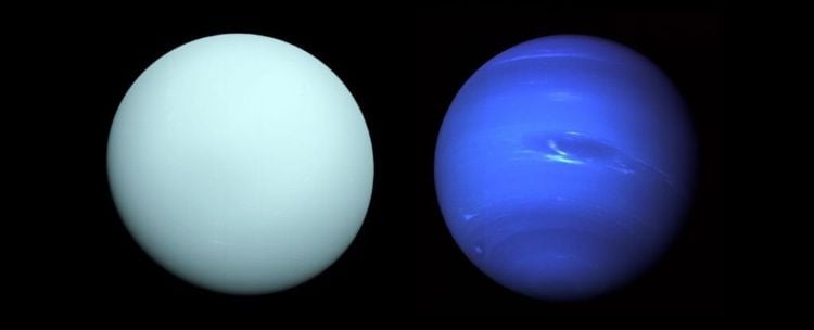
What if our understanding of Uranus and Neptune’s compositions have been wrong, specifically regarding their classifications as “ice giants”? This is what a recent study accepted for publication in *Astronomy & Astrophysics* hopes to address as a team of researchers from the University of Zurich investigated the interior structures of Uranus and Neptune. This study has the potential to help scientists not only better understand the formation and evolution of Uranus and Neptune but could also provide key insights into Jupiter and Saturn, and gaseous exoplanets, too.
For the study, the researchers analyzed a series of computer models designed to simulate the interiors of Uranus and Neptune based on current planetary data for each, including mass, equatorial radius, pressure, reference radius, rotation period, and gravitational moments. Combining this with new algorithms, the researchers wanted to ascertain a better understanding of the interiors of both Uranus and Neptune and planetary interiors, overall. While a planet’s equatorial radius is measured from the center of the planet to its equator, this works best for solid surfaces. Since Uranus and Neptune are gas planets, their equatorial radii are measured from the center to the edge of their gaseous atmospheres. Therefore, reference radii are used for gas planets like Uranus and Neptune for modeling purposes.
In the end, the researchers found interiors compositions of Uranus and Neptune are dominated by rock and water. Specifically, their rock-to-water ratios list Uranus having a larger ratio than Neptune by almost 10 times. As a result, the researchers allude to changing the longstanding classification of Uranus and Neptune being “ice giants” as being “rock giants”.
The study concludes by stating, “With the potential for future dedicated missions to Uranus and Neptune, our method also provides a flexible and unbiased tool for interpreting forthcoming data. Ultimately, the interiors of Uranus and Neptune remain enigmatic, not because they are beyond reach, but because the data required to resolve their secrets are still out of grasp. Until then, only a plurality of models, not a singular one, can capture the full extent of possibilities for their hidden depths.”
The only human-made spacecraft to have visited Uranus and Neptune is NASA’s Voyager 2, which occurred in January 1986 and August 1989, respectively. Despite these two brief flybys, Voyager 2 obtained a wealth of knowledge about both gas giants, including data regarding their atmospheres, interiors compositions, moons, and rotational properties. For Uranus, Voyager 2 discovered two new rings and 10 moons, which provided scientists with new insights into rocky planetary body formation and evolution. Voyager 2 was the first to discover that Uranus rotated on its side but still exhibited a magnetic field like Earth’s. The planet’s sunlit pole was found to emit ultraviolet radiation and even emit a peculiar glow. For Neptune, Voyager 2 measured the planet’s mass while also observing auroras that were weaker than on Earth since Neptune’s magnetic field was offset from the center of the planet.
Future planned missions to Uranus have either only been proposed or are still in the planning stages, the latter of which is China’s Tianwen-4 spacecraft, and with NASA considering the Uranus Orbiter and Probe mission. For Neptune, more than a half-dozen missions have been proposed, most notably NASA’s Neptune Odyssey mission. One of the primary reasons for not sending another spacecraft to Uranus or Neptune is the enormous distance and time it would take to reach them. Voyager 2 circumvented this by taking advantage of a planetary alignment that only happens every 175 years, enabling Voyager 2 and its twin spacecraft, Voyager 1, to visit all the outer planets in a fraction of the time.
Uranus and Neptune have long been designated as “ice giants” due to their higher water-to-rock ratio than Jupiter and Saturn, which are primarily comprised of hydrogen and helium and are appropriately designated as “gas giants”. Therefore, studies like this not only help scientists understand the formation and evolution of gas giants within our solar system but also shed light on the formation and evolution of gas giant exoplanets, too. What new discoveries about the interiors of Uranus and Neptune will researchers make in the coming years and decades? Only time will tell, and this is why we science!
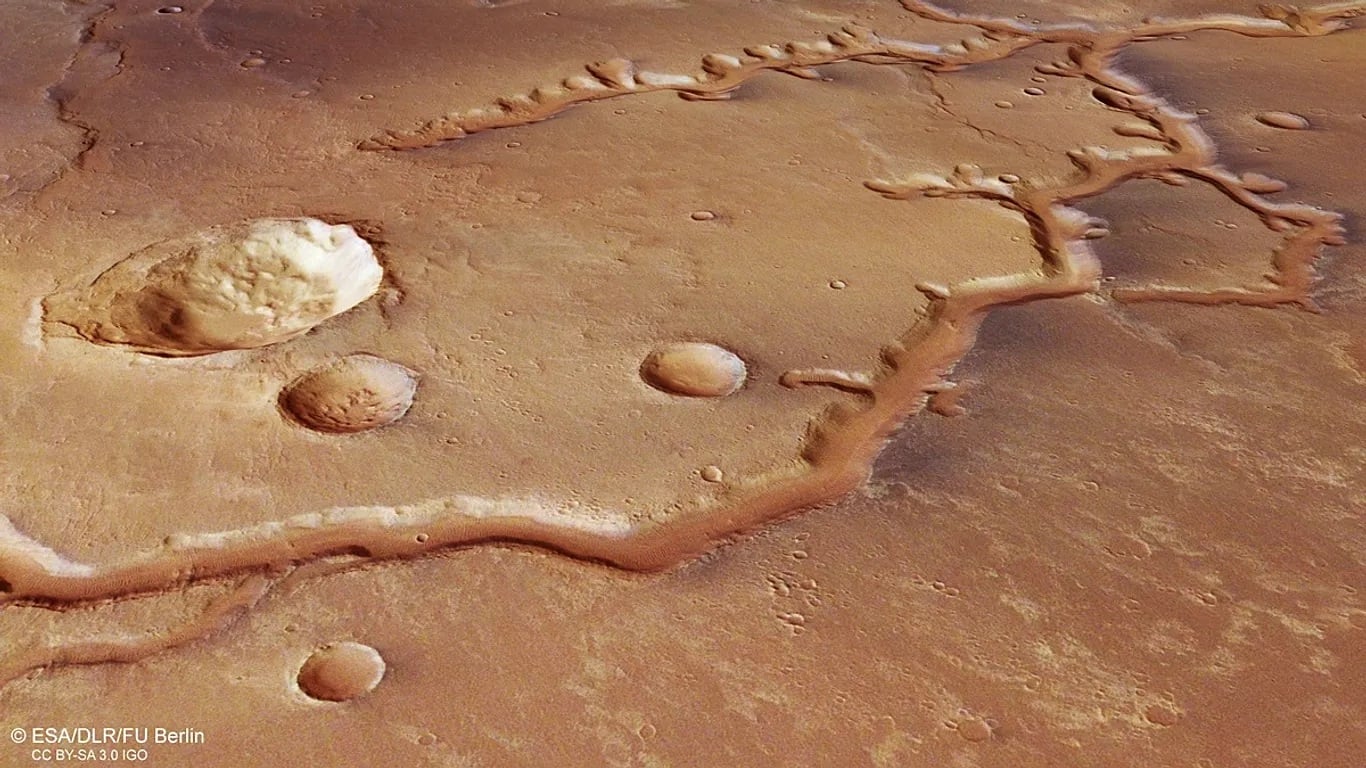
The ESA's Mars Express captured this image of an ancient, dried-up river system that spans nearly 700 km (435 mi) across the surface of Mars. Credit: ESA/Björn Schreiner/FU Berlin
Today, it's a scientific consensus that Mars was once a very different place, with a warmer, denser atmosphere and liquid water on its surface. This is evidenced by flow channels, delta fans, lakebeds, and many other features that form in the presence of flowing water here on Earth. Based on the way many of these channels feed into the Northern Lowlands on Mars, scientists speculate that this region was once home to an ocean that covered the northern hemisphere. According to new research from the University of Arkansas, there is a strong case for the existence of this ancient ocean.
This was the conclusion reached by geosciences PhD candidate Cory Hughes, who studies the geology of the Earth to the geological history of Mars. For years, researchers have studied sandstone formations in northwestern Arkansas, which were created by rivers that flowed across the area 300 million years ago. By analyzing images taken by NASA's Mars Reconnaissance Orbiter (MRO), Hughes and his colleagues identified key features in delta fans located in Aeolis Dorsa, a northern region within Utopia Planitia. On Earth, these features are known as "backwaters," which form where rivers narrow before emptying into oceans.
Hugh was joined by John B. Shaw, an associate professor of geosciences and the Vice Chair of the Department of Geosciences at the University of Arkansas, as well as Anjali M. Fernandes and Travis E. Swanson. Fernandes is an Associate Professor of Earth and Environmental Sciences at Denison University, while Swanson is a geoscientist with the Water Institute (a Louisiana-based applied research organization dedicated to supporting coastal and river delta regions). The results of their analysis were published in the journal Geophysical Research Letters.
Image of the Edington Sandstone formation, located in northwestern Arkansas.
Credit: Office of the State Geologist
On Earth, rivers that have no system of levees or human-built barriers shift constantly as they snake across the landscape. The sediment they carry erodes one side, causing the river to bend in that direction while depositing sand and fine dirt on the opposite side, also known as a "channel belt." As a river approaches an open body of water (like an ocean), its velocity will slow down, causing it to carry less sediment. This leads to sediment being deposited, forming river deltas, and causes the channel belt to narrow before it reaches the ocean. This section is known as the "backwater zone," which can extend for hundreds of kilometers.
Over time, gravity will pull the coarsest grains to the bottom of the river, which will become buried if the river dries up. This is believed to have been what happened on Mars billions of years ago after the planet's atmosphere was slowly stripped away by solar wind (owing to the disappearance of its magnetic field). When rivers dry up, heat and pressure will turn the sediment in the riverbeds into sandstone deposits. On Earth, tectonic activity pushes this stone to the surface, where wind and rain erosion eventually leave behind a ridge known as "inverted channel" (or "inverted ridge").
This is what took place in northwestern Arkansas roughly 300 million years ago, when a river that ran from modern-day Indiana flowed into a sea that covered central Arkansas. When the ancient river dried up, what resulted was the Wedington Sandstone formation, the only known example of an inverted river delta on Earth. The presence of similar ridges and channel belts on Mars provides direct evidence that rivers once flowed there that emptied into an ocean that covered the northern hemisphere. However, since Mars lacks plate tectonics, its inverted ridges likely formed when finer deposits around the sandstone were eroded.
"This is a large-scale process taking place, which is why we're able to see it from space on Mars," said Hughes. "These are very mature deltas. This is a strong point in favor of an ancient ocean, or at the very least a large sea." Back in January, Hughes, Shaw, and the Department of Geosciences at the University of Arkansas hosted a conference attended by 12 planetary scientists from NASA's Jet Propulsion Laboratory, the Planetary Science Institute (PSI), the University of Texas, and Stanford University. As part of the conference, attendees visited the Edington Sandstone formation to observe its similarities to the Aeolis Dorsa region.
As Shaw noted, this latest piece of evidence of Mars' warmer, watery past also bolsters the case for the existence of life on Mars at one time. "We don't know of any lifeforms on Earth, or anywhere in the universe, that don't require liquid water, he said. "So the more liquid water we have on Mars, a simple argument could be made that you have a higher chance of life."
A scientist has warned that the interstellar visitor moving closer to Earth could be a 'Trojan Horse,' where a technological object masquerades as a comet.
The Harvard professor, who has been monitoring 3I/ATLAS since its discovery in July, said Wednesday that there is a 30 to 40 percent chance the object 'does not have a fully natural origin.'
Avi Loeb admitted that his ranking could change after new data comes in over the next few months, including observations next month from a spacecraft en route to Jupiter and when 3I/ATLAS comes 167 miles within Earth in December.
'We have no idea of the amount of traffic of extraterrestrial probes in the vicinity of the Solar system,' he said in a blog post.
'Given the uncertainty, it would be prudent to collect as much data as possible on interstellar objects from all directions and assess the level of risk based on that data.'
The object, a rare visitor from beyond the solar system, is unusually large and closely aligned with the plane of the planets, making it visible to orbiters around Mars over the weekend.
NASA's rover on the Martian planet snapped images of 3I/ATLAS, which captured it as a massive cylindrical object, sparking fresh theories about alien technology.
A Harvard scientists said there is a possibility that the interstellar visitor moving closer to Earth could be a 'Trojan Horse,' where a technological object masquerades as a comet
Loeb analyzed the Perseverance rover's photos by calculating its distance, speed, and camera settings.
According to his initial study, Loeb was not convinced that 3I/ATLAS is actually a massive cylindrical object, noting that the strange shape might have been a trick of the rover's camera stretching the object out.
He explained that the apparent cylinder from the rover's 'Navcam' was likely caused by the camera stacking hundreds of images of 3I/ATLAS over a period of about 10 minutes, making it look more like a log than a ball.
The professor added that 3I/ATLAS is likely smaller and rounder, but still massive, with a potential diameter of more than 28 miles across.
Dr Horace Drew, a retired senior researcher at Australia's Commonwealth Scientific and Industrial Research Organization (CSIRO), noted that the mysterious green glow seen in some images could be a result of the object being an interstellar spacecraft coated in nickel.
He explained that humans use the same practice on Earth-made space technology on a much smaller scale.
'It is not a "comet,"' Drew shared in a post on X.
Drew disagreed with Loeb's conclusion that the cylindrical shape was a result of the Mars rover sending back a stretched image over several minutes, claiming that an amateur astronomer on Earth captured a similar shape with their telescope.
+1
View gallery
The Perseverance rover on Mars captured new images of the interstellar object 3I/ATLAS as it passed by the planet this weekend
Unlike natural comets, which always emit nickel alongside iron, 3I/ATLAS shows the metallic element without any detectable iron.
Loeb explained that this nickel signature is a hallmark of industrial production of nickel alloys.
'Is this anomaly another clue for a possible technological origin of 3I/ATLAS?' Loeb wrote in a blog post.
'The paper suggests that chemical formation occurs through the nickel carbonyl channel, an extremely rare process in comets, but a standard technique in industrial nickel refining,' he added.
The new study, published by astrophysicists in Chile in late August, found that 3I/ATLAS is shedding nickel at roughly five grams per second and cyanide at 20 grams per second, with both rising sharply as the object moves closer to the sun.
Researchers noted that the mechanisms driving these emissions are not typical of natural cometary processes.
They hypothesized that nickel might be released from dust through gentle processes, such as sunlight, causing it to evaporate or breaking down small nickel-containing compounds.
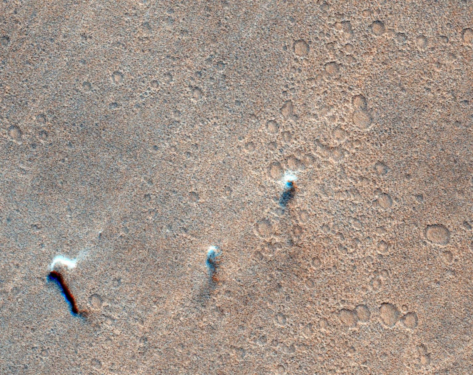
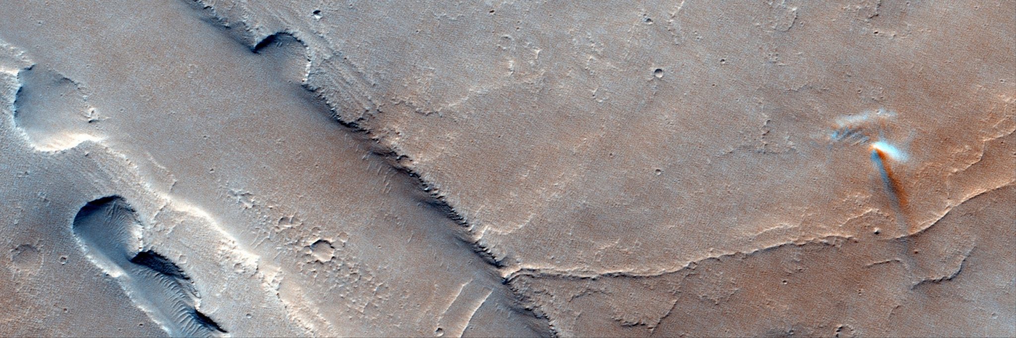
Even the smallest details of the Martian landscape can hide incredible phenomena. It turns out that dust whirlwinds, also known as “dust devils” on the Red Planet, move at incredible speeds that significantly exceed scientists’ previous estimates.
A camera aboard ESA’s ExoMars Trace Gas Orbiter captured three dust devils moving across the surface of Mars. Image: ESA/TGO/CaSSIS
Researchers from the University of Bern in Switzerland analyzed archives of images from the European Space Agency’s Mars Express and Trace Gas Orbiter spacecraft. Using artificial intelligence models, they were able to track more than a thousand dust devils recorded over the past two decades.
The result is impressive: these whirlwinds can reach speeds of up to 158 km/h, making them much more powerful than previously thought. This discovery radically changes our understanding of the dynamics of the Martian atmosphere.
Turning artifacts into scientific data
The most ingenious aspect of this study was the method. None of the orbital vehicles were specifically designed to measure wind. However, the team found a way. They noticed slight color shifts in the images caused by split-second delays between the camera channels. These shifts are usually considered technical noise. But everything that moves across the surface of Mars — clouds or dust whirlwinds — leaves its mark in these shifts. By analyzing these tiny shifts between frames, scientists were able to calculate the speed and direction of each whirlwind.
Dust devil on the surface of Mars. Photo: ESA
As research leader Valentin Bickel noted, they literally “turned image artifacts into valuable scientific measurements.”
This fundamental discovery has direct practical significance for the exploration of Mars. A dust devil is a kind of visualizer of invisible wind. By measuring it, we obtain a map of winds across the entire surface of the planet.
Animation of the movement of the “dust devil” on Mars
This information will be invaluable for planning future landings. Scientists will be able to more accurately assess wind conditions at the landing site, predict how much dust will settle on the rovers’ solar panels, and determine the optimal frequency of self-cleaning to maintain viability.
Rhythms of Martian weather
The new catalog also confirms that dust devils have their “favorite” places and times. They most often occur on dust plains such as Amazonis Planitia during the warm seasons of spring and summer. Their activity peaks between late morning and early afternoon, which is very similar to patterns on Earth.
Map showing 1,039 dust devils detected on Mars, recorded over a period of 20 years by ESA’s Mars Express and ExoMars Trace Gas Orbiter. Image: ESA/TGO/CaSSIS
However, there is a key difference on Mars. Since no rain falls there, dust can remain in the atmosphere for months. Understanding how and when it enters the atmosphere is key to unraveling the planet’s long-term climate cycles and accurately predicting Martian weather. As ESA scientist Colin Wilson noted: “Dust on Mars affects absolutely everything.”
After half a century, samples collected during NASA’s 1972 Apollo 17 Moon mission are still revealing new secrets about the lunar surface.
Fortunately for today’s scientists, the Apollo Moon missions had the foresight to store samples for exploitation by technologies and methodologies not yet known at the time. Because of that, a new study in JGR: Planets brings to light a surprising sulfur isotope hiding in the lunar regolith that may also provide clues to the origin of our solar system.
Apollo Sample Preservation
Apollo 17 astronauts Gene Cernan and Harrison Schmitt collected these samples of volcanic material from the Taurus Littrow region, after pushing a hollow metal cylinder 60 centimeters into the regolith. Upon their return, the NASA Apollo Next Generation Sample Analysis (ANGSA) program preserved the entire tube full of material in a helium chamber for future scientists to study.
After fifty years on the shelf, NASA has finally begun allowing researchers to apply modern scientific tools to ANGSA samples. Gaining access to the precious samples is no easy feat, though. A rigorous and competitive application process is in place to ensure that ANGSA releases materials only to the most deserving projects.
One of the recipients of the lunar samples was James Dottin of Brown University, whose work proposed using ion mass spectrometry on the lunar soil for the first time, in an effort to explore the sulfur in what resembled mantle-derived volcanic rock.
“I was targeting sulfur that had a texture that would suggest it was erupted with the rock and not added through a different process,” Dottin explained.
Sulfur-33
The unexpected sulfur compounds found in the samples were strange for their high depletion of sulfur-33, which is among the four most radioactively stable sulfur isotopes. Compared to sulfur-33 samples recovered on Earth, the lunar samples are far different, as terrestrial sulfur-33 is typically far less depleted.
“Before this, it was thought that the lunar mantle had the same sulfur isotope composition as Earth,” Dottin said. “That’s what I expected to see when analyzing these samples, but instead we saw values that are very different from anything we find on Earth.”
Isotope ratios form a sort of “fingerprint” from which rocks can be identified as originating from the same source. Existing research has shown similarities between oxygen on the Moon and Earth, leaving scientists to expect a resemblance between sulfur isotopes as well.
“My first thought was, ‘Holy shmolies, that can’t be right,’” Dottin exclaimed. “So we went back to make sure we had done everything properly, and we had. These are just very surprising results.”
Exploring Lunar Origins
Dottin suggests two possibilities behind the unexpected sulfur. One is that the early moon briefly held a thin atmosphere, just enough to allow for reactions between ultraviolet light and sulfur. This could have depleted the isotope early on, carrying significant implications for lunar evolution.
“That would be evidence of ancient exchange of materials from the lunar surface to the mantle,” Dottin said. “On Earth, we have plate tectonics that does that, but the Moon doesn’t have plate tectonics. So this idea of some kind of exchange mechanism on the early Moon is exciting.”
Another possibility is that the depleted isotope arrived from the Moon’s initial formation. The most commonly accepted lunar origin story is that Theia, an object roughly the size of Mars, impacted the ancient Earth, sending off debris that eventually formed the Moon. If this were the case, the anomalous sulfur isotope may be remnants of Theia, which could have had a far different sulfur signature than the Earth.
While both theories are possible, no clear evidence from the isotopes themselves currently supports one over the other. Dottin hopes that continued analysis of sulfur isotopes from different bodies in our solar system, such as Mars, will help identify the correct explanation and provide a better understanding of how our solar system formed as a whole.
Ryan Whalen covers science and technology for The Debrief. He holds an MA in History and a Master of Library and Information Science with a certificate in Data Science. He can be contacted at ryan@thedebrief.org, and follow him on Twitter @mdntwvlf.
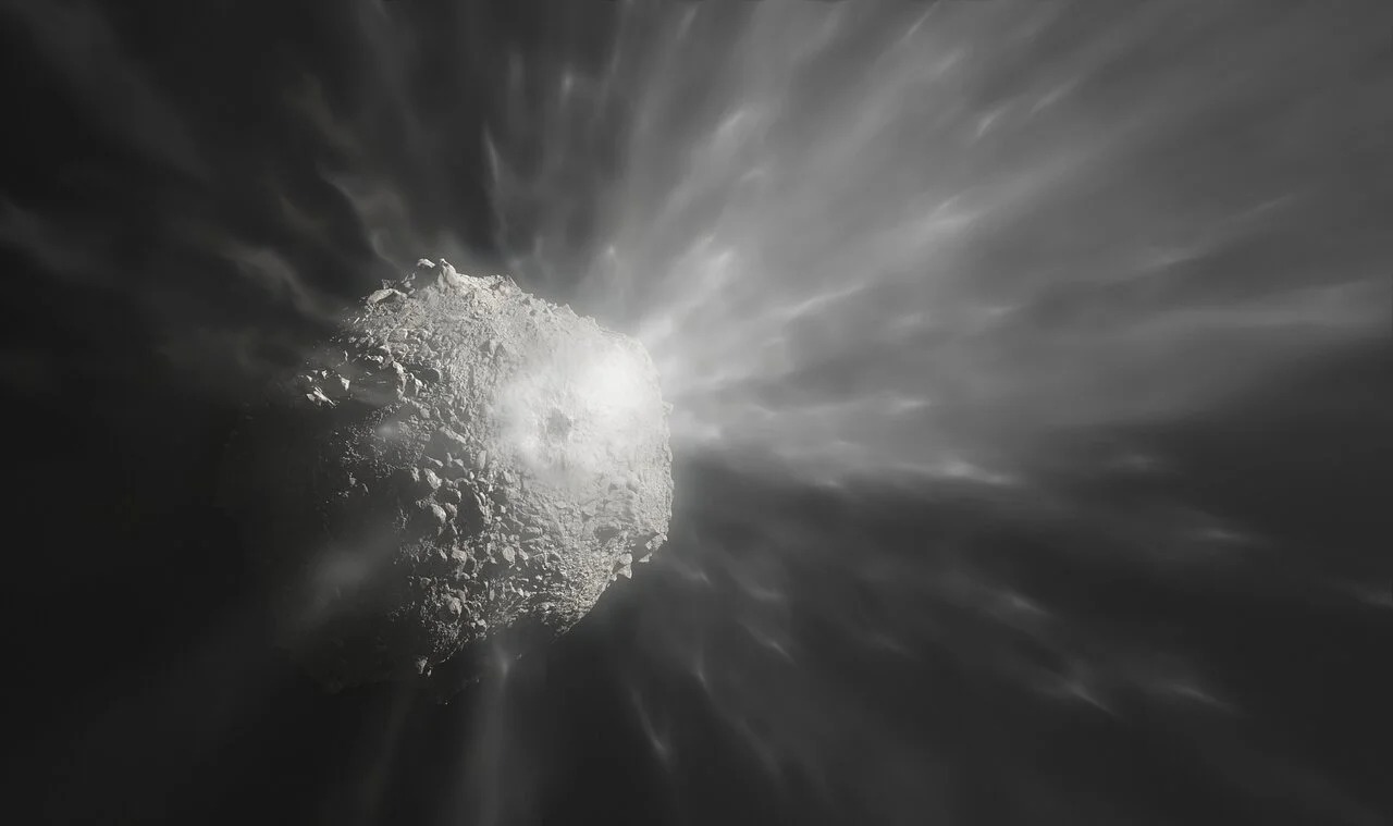
Scientists observed the interstellar comet 3I/ATLAS using the Swift ultraviolet space telescope. With the help of this instrument, they found hydroxyl ions, indicating the presence of water on the comet. This allows us to compare it to the “cosmic icebergs” that are constantly present in our Solar System.
Comet 3I/ATLAS. Source: starwalk.space
Water on comet 3I/ATLAS
Scientists have published a study of the interstellar comet 3I/ATLAS using NASA’s Swift space telescope. This orbital observatory operates in ultraviolet light and is capable of performing spectral analysis for this wavelength range. As a result, scientists learned something interesting about its chemical composition.
In particular, water was found on it. More precisely, the telescope captured ultraviolet light from the hydroxyl ion OH, but it cannot be anything other than the decay product of a water molecule. Thus, a safe assumption is that it is present there.
But the really important thing was that this discovery was made when 3I/ATLAS was three times farther from the Sun than Earth. At this distance, comets in the Solar System do not show any activity. But for some reason, up to 40 kg of water evaporated from the interstellar space every second.
Origin of comets
Nevertheless, scientists believe that ultraviolet research has enabled them to compare 3I/ATLAS with comets in the Solar System. Its abnormal activity can be easily explained by the existence of complex layers of ice on the surface of its core. Similar ones were observed in several objects that formed far from the Sun.
3I/ATLAS is only the third interstellar object that scientists have been able to study in detail. And they are all completely different. Oumuamua was completely dry, while Borisov’s comet was rich in carbon monoxide. And now 3I/ATLAS shows a large amount of water.
All this indicates their formation under different conditions. This means that the systems from which they originate have to be really different from each other. Although this conclusion is based on a small sample size, future interstellar visitors will be able to provide more information.
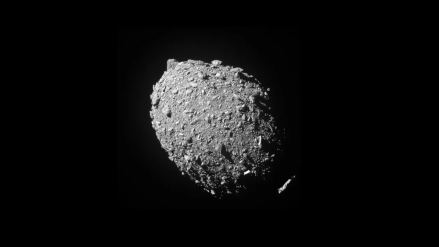
A new study has refuted the popular theory about the unexpected shortening of Dimorphos’ orbital period. Scientists have discovered that the proposed mechanism would actually have the opposite effect.
Asteroid Dimorphos. Source: NASA/Johns Hopkins APL
In 2022, NASA’s Double Asteroid Redirection Test (DART) vehicle deliberately collided with Dimorphos, a small satellite of the near-Earth asteroid Didymos. The mission was dedicated to protecting our planet. Scientists wanted to test whether the space ram technique could be used to change the orbit of a celestial body threatening Earth.
The demonstration was quite impressive. The period of Dimorphos’s orbit around Didymos after the impact was reduced by as much as 33 minutes, which far exceeded the scientists’ expectations. However, in the following weeks, something unusual happened: observations revealed an additional reduction in the orbital period of another 30 seconds. This situation has left researchers perplexed as to its causes.
The initial hypothesis suggested a scenario known as binary system hardening. It involves debris ejected as a result of the collision interacting with Dimorphos’ gravity and ultimately being ejected from the system, causing it to lose angular momentum and acquire a tighter orbit.
Illustration of debris ejected after the collision of the DART spacecraft with the asteroid Dimorphos. Source: ESO
However, the results of a recent study conducted by scientists from Université Côte d’Azur have cast doubt on this scenario. Simulation showed that Dimorphos was too weak a “scatterer” to affect the angular momentum of the system.
If the ejected particles do not disperse, the most likely consequence will be re-accretion, in which the debris falls back onto one of the components of the binary system. Since the collision between DART and Dimorphos was head-on, most of the ejected material entered prograde orbits. This means that they are moving in the same direction as Dimorphos and Didymos in their mutual motion around the Sun. In turn, when material moving in the prograde direction re-accretes, it increases the angular momentum of the binary system. This leads not to a decrease, but to an increase in the orbital period, which contradicts the observed pattern.
All this suggests the existence of an additional mechanism that can counteract this effect and cause the observed decrease in the orbital period. Researchers suggested that the most likely alternative explanation is a change in the shape of Dimorphos after the impact. At the same time, they admitted that further research would be needed to reach a final conclusion.
Perhaps the European Hera mission will provide the answer to this question. It will reach Didymos and Dimorphos at the end of 2026.
The European Space Agency (ESA) has finally shared new details about the mysterious interstellar visitor days after its closest approach to Mars.
The object, dubbed 3I/ATLAS, came within 18.6 million miles of the Red Planet on October 3, and while NASA quickly uploaded images captured by its Perseverance rover on the Martian surface, ESA had remained quiet until now.
The ESA's ExoMars Trace Gas Orbiter (TGO) captured images of the object, appearing as a tiny, blurry white dot in a series of images.
The object's icy nucleus and its surrounding halo of gas and dust, called a coma, could not be distinguished separately, but the faint glow was clearly visible against the blackness of space.
Scientists were initially unsure whether either orbiter's cameras would detect the comet at all. Both are designed to photograph Mars' bright, rocky surface from just a few hundred to a few thousand miles away, not to capture a dim object tens of millions of miles distant.
'This was a very challenging observation for the instrument,' said Nick Thomas, principal investigator of the CaSSIS camera.
'The comet is around 10,000 to 100,000 times fainter than our usual targets.'
The visible coma suggested that 3I/ATLAS is beginning to heat up as sunlight reaches its surface, causing ice to vaporize and release dust, which gives comets their ghostly appearance.
The European Space Agency finally released images 3I/ATLAS, captured by a Mars orbiter
Originating from outside our Solar System, 3I/ATLAS is only the third interstellar comet ever seen, following 1I/ʻOumuamua in 2017 and 2I/Borisov in 2019.
'These comets are absolutely foreign,' the ESA shared on Tuesday, referring to 3I/ATLAS as a 'rare visitor.'
'Every planet, moon, asteroid, comet and lifeform in our Solar System shares a common origin.
'But interstellar comets are true outsiders, carrying clues about the formation of worlds far beyond our own.'
ExoMars TGO captured the series of images with its Color and Stereo Surface Imaging System (CaSSIS), which was unable to distinguish the nucleus from the coma due to 3I/ATLAS being too far away.
However, the device was able to image the coma that spanned thousands of miles across.
'The full size of the coma could not be measured by CaSSIS because the brightness of the dust decreases quickly with distance from the nucleus,' the ESA report shared.
'This means that the coma fades into the noise in the image.'
3I/ATLAS made its closest approach to Mars on October 3 and is set to continue through our Solar System
NASA was quick to release images of the object snapped by its Perseverance rover on Mars. The agency uploaded them over the weekend
Typically, material from the coma is swept into a long tail that can stretch for millions of miles as the comet moves closer to the sun.
'The tail is much dimmer than the coma. We can’t see the tail in the CaSSIS images, but it may become more visible in future observations as the comet continues to heat up and release more ice,' shared the ESA.
The images have flooded X, where one user posted: 'ESA Finally Releases Images of 3I/ATLAS. After days of silence, ESA finally broke the blackout.'
The ESA's report comes days after NASA released its view of the visitor.
Harvard astrophysicist Avi Loeb, who has been convinced that the object could be an alien craft or probe, analyzed the Perseverance rover's photos by calculating its distance, speed, and camera settings.
According to his initial study, Loeb was not convinced 3I/ATLAS is actually a massive cylindrical object, noting that the strange shape might have been a trick of the rover's camera stretching out its shape.
He explained that the apparent cylinder from the rover's 'Navcam' was likely caused by the camera stacking hundreds of images of 3I/ATLAS over a period of about 10 minutes, making it look more like a log than a ball.
The professor added that 3I/ATLAS is likely smaller and rounder, but still massive, with a potential diameter of more than 28 miles across.
Dr Horace Drew, a retired senior researcher at Australia's Commonwealth Scientific and Industrial Research Organization (CSIRO), noted that the mysterious green glow seen in some images could be a result of the object being an interstellar spacecraft coated in nickel.
Color-enhanced images shared by multiple social media users revealed a strange green glow around 3I/ATLAS
Drew explained that humans use the same practice on Earth-made space technology on a much smaller scale.
'It is not a 'comet,'' Drew declared on a post on X Monday morning.
Drew disagreed with Loeb's conclusion that the cylindrical shape was a result of the Mars rover sending back a stretched image over several minutes, claiming that an amateur astronomer on Earth captured a similar shape with their telescope.
'We can see an extended white shape, with a green coma outside. Not a small white ball,' Drew explained in a post about the astronomer's photograph.
Drew, who earned his PhD in chemistry from the California Institute of Technology, added that previous images of the interstellar object were allegedly from a 'head-on view' and didn't capture its shape from the side, like the new photos from Mars.
Loeb said he's excited about another image taken by a different Mars camera, called HiRISE, which has better resolution and could show 3I/ATLAS more clearly.
That image is being sent back to Earth by the Mars Reconnaissance Orbiter (MRO) and has yet to be released by NASA.
Brits have been left in awe after spotting what is believed to be a 'meteor' glowing through the night sky.
Lucky stargazers in Northfields and Ealing, west London, have reported seeing a blue-ish green blob race through the city's sky on Tuesday.
One onlooker described seeing the 'streak' of light dash through the clouds at around 8.10pm to 8.30pm, and initially believed it was fireworks.
'I'm used to seeing planes coming and going to Heathrow, and also helicopters coming and going; this was not that,' they wrote on Reddit.
'My next thought was fireworks but I'm 90% sure it wasn't that, and there was no explosion.
'For reference it was about the same size as the full-ish moon tonight, visible through the clouds, but as a much brighter blue-green color and, again, moving quite fast.
'It was a very odd combination of speed, size and brightness and didn't look like anything I've ever seen in the sky here before.'
Others claimed to have seen the unusual sighting from Wimbledon and Hampstead Heath, with some even catching a glimpse as far afield as Brighton and Grantham.
Lucky stargazers in Northfields and West Ealing, west London, and further afield, have reported seeing a blue-ish green blob race through the city's sky on Tuesday night
It has not yet been confirmed what the colourful 'streak' in Tuesday's sky was, however, the Daily Mail has approached the Met Office for comment.
It comes as earlier this week Jessica Lee, an astronomer at the Royal Observatory Greenwich also said sky gazers could expect the Draconid meteor shower today.
But, the meteor shower, which is expected to peak Wednesday night may be difficult to see due to the moonlight, Ms Lee warned.
'The Draconids meteor shower is named after the constellation of Draco the dragon,' Ms Lee said.
'This is because, although meteors appear all over the sky, they all appear to emerge or radiate from a single point that lies within this constellation.
'The meteor shower is visible from the 6th until the 10th of October this year.
'The best time will be from around 8pm on the 8th of October.
'At this time, that radiant point within Draco will be in the north-west of the sky, slowly getting lower in the sky until sunrise.
'The moon will be almost full on this night, however, so it could make the meteors tricky to see.'
The Draconids are caused when debris from the comet 21P/Giacobini-Zinner burns up in the Earth's atmosphere, Ms Lee added.
The meteor is believed to have exploded over northern Scotland, with the 'fall zone' straddling Loch Treig in Lochaber, Highland.
The aerial event was captured on some cameras and shared on social media, showing a big yellow spark soaring through the dark sky.
Members of the public have since been tasked to look for the fragments, which should appear 'black, glassy and shiny'.
Meteorites – rocks from outer space and have fallen to the surface of a planet – may have delivered essential compounds facilitating the evolution of life as we know it.
Professor Luke Daly, a planetary geoscientist and space rock hunter at the University of Glasgow, called them 'time capsules of the early solar system'.
'They hold a wealth of information about how our solar system formed and developed,' he said.
'This is a very exciting opportunity to learn more about where this rock came from and where it has been and fill in a bit more of the jigsaw of our solar system's history.'
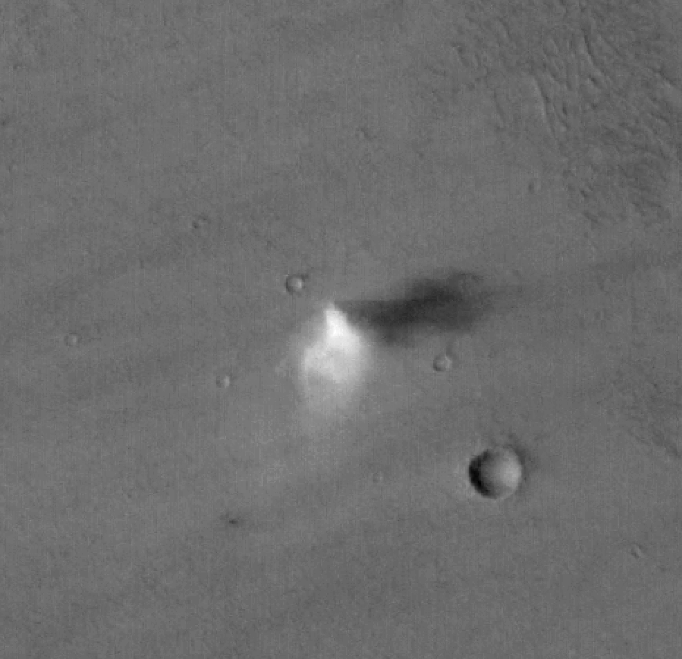
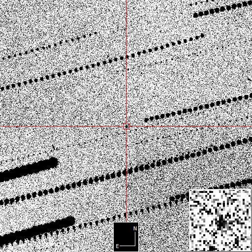
A small, giraffe-size asteroid called 2025 TF came closer to Earth than some satellites on Wednesday (Oct. 1), stunning astronomers who first spotted it hours later.
The near-Earth asteroid 2025 TF (red crosshairs) came about as close to Earth as the International Space Station on Wednesday (Oct. 1), evading detection until hours later. (Image credit: ESA / Las Cumbres Observatory)
A smallasteroid zoomed past Earth closer than most satellites last week — and astronomers didn't notice it until hours later.
The surprise asteroid encounter occurred at 8:47 p.m. EDT on Tuesday, Sept. 30 (Wednesday, Oct. 1 at 0047 GMT) when the roughly giraffe-size space rock flew over Antarctica at just 265 miles (428 kilometers) above Earth's surface, according to newly released data from the European Space Agency (ESA). Astronomers first spotted the sneaky space rock — now officially named 2025 TF — a few hours later, using observations from the Catalina Sky Survey, a NASA-funded mission to track near-Earth objects.
Measuring an estimated 3.3 to 9.8 feet wide (1 to 3 meters), the asteroid posed no serious threat to Earth, ESA added, and likely would have burned up as a bright fireball had it reached Earth's atmosphere. However, even small asteroids can cause big problems for spacecraft — and this one happened to whip by at around the same altitude where the International Space Station usually orbits. Fortunately, no spacecraft were in the space rock's path.
Space agencies like NASA and ESA track thousands of known near-Earth objects, carefully monitoring which ones pose the greatest risk of colliding with Earth. (Currently, no known objects pose a significant threat to our planet for at least 100 years). For an asteroid to be considered "potentially hazardous," it must measure at least 460 feet (140 m) in diameter, and follow an orbit that comes within 4.65 million miles (7.48 million km) of Earth — or roughly 20 times the average distance between Earth and the moon. Asteroid 2025 TF falls far short of that size threshold, which may also explain why it evaded detection until after it had passed.
25 Most Terrifying Things in Space You Never Knew – Everything You Missed | Astronomy Facts
Astronomers at ESA's Planetary Defence Office observed the asteroid shortly after it was discovered, ESA officials reported. NASA, which has paused all public communications during the ongoing U.S. government shutdown, did not make any announcements about the asteroid — however, an entry for the asteroid has been updated on NASA's Center for Near-Earth Object Studies website. The tiny space rock is not expected to fly by our planet again until April of 2087, according to NASA.
Earth may have dodged a "fireball" with this near-miss asteroid encounter, but skywatchers can expect more fiery lights this week. The Draconid meteor shower peaks on Wednesday (Oct. 8) — and while the display of shooting stars will be somewhat dampened by the light of the full Harvest Moon, the appearance of bright fireball meteors is possible. No asteroids play a part in this annual sky show; the Draconids come from icy debris left by the comet 21P/Giacobini-Zinner, which blazes through the inner solar system every 6.5 years.
A huge asteroid came within 300 miles of hitting Earth, and scientists only noticed after it had already skimmed past the planet.
The 9.8-foot (three metre) space rock, dubbed 2025 TF, flew over Antarctica in the early hours of October 1.
Passing at an altitude of just 265 miles (428 kilometres), the rock came closer to the Earth's surface than the orbit of the International Space Station.
However, space agencies only realised the near-miss had occurred when the asteroid was detected by the Catalina Sky Survey a few hours later.
While a miss this close might sound alarming, the European Space Agency (ESA) claims there was never any serious danger.
Based on its estimated size, 2025 TF would have most likely burned up or exploded in the atmosphere rather than slamming into the surface.
ESA said in a statement: 'Objects of this size pose no significant danger.
'They can produce fireballs if they strike Earth’s atmosphere, and may result in the discovery of small meteorites on the ground.'
A huge asteroid passed within 300 miles of Earth, but astronomers only realised the close encounter had happened when telescopes picked up the asteroid hours later. Pictured: Image of the asteroid taken by the Las Cumbres Observatory
After the asteroid passed, astronomers at the ESA's Planetary Defence Office observed it using the Las Cumbres Observatory in Australia.
This allowed for a more accurate estimate of the object's size and worked out that it had reached its closest point to Earth at exactly 01:47:26 BST.
ESA says: 'Tracking down a metre-scale object in the vast darkness of space at a time when its location is still uncertain is an impressive feat.
'This observation helped astronomers determine the close approach distance and time given above to such high precision.'
While it might not have done much damage to the planet, even a small space rock could have caused serious damage to a spacecraft.
This is particularly concerning since 2025 TF passed within the orbit of the ISS.
However, there were thankfully no spacecraft or satellites in the way as this asteroid passed.
Although NASA has paused all public communication during the government shutdown, the space agency has created an entry for 2025 TF on its Center for Near-Earth Object Studies website.
The asteroid, dubbed 2025 TF, passed 265 miles (428 kilometres) above Antarctica in the early hours of October 1. This put it at roughly the same altitude as the International Space Station (stock image)
How many Near Earth Asteroids have been detected?
Total: 39,585
Over 140 metres: 11,453
Over 1 kilometre: 877
Figures as of October 4, 2025
According to this entry, the asteroid will next return to Earth in 2087 when it will pass within 3,710,795 miles (5,971,946 km) of the planet.
Although 2025 TF's orbit takes it well within this distance, it is simply too small to be considered a hazard.
This small size also makes it extremely difficult to spot, which likely explains why it wasn't noticed until it had already passed Earth.
Each year, space agencies around the world discover thousands of so-called near-earth asteroids (NEAs).
These range from relatively harmless space rocks like 2025 TF to enormous 'city-killers' like the asteroid 99942 Apophis.
As of October 4, there were 39,585 known NEAs, including 11,453 asteroids larger than 460 feet (140 metres) in diameter.
Of these, about 2,500 are considered potentially hazardous, according to the International Astronomical Union's (IAU) Minor Planet Center.
2025 TF measures up to 9.8 feet (three metres) in diameter. Even though its orbit (illustrated) took it close to Earth, it is too small to be considered a potentially hazardous object
Each year, astronomers find thousands of Near Earth Asteroids (NEAs), many of which are over 460 feet (140 metres) in diameter. However, there are currently no objects that pose a risk to Earth in the next 100 years
These hazardous space rocks are subject to a much higher level of scrutiny, and their orbital paths are carefully calculated to see if they will hit Earth.
But, as this near miss demonstrates, even the world's most sophisticated planetary defence systems can't capture anything.
While scientists expect that almost all city or planet-killer asteroids will be detected long before they arrive, small but dangerous asteroids can still slip through.
In January last year, NASA's Scout impact hazard assessment system alerted authorities to a six-foot (two metre) asteroid heading towards Berlin just 95 minutes before it impacted.
Since this time, planetary defence systems have greatly improved, but many scientists still think more work needs to be done to ensure similar asteroids aren't missed in the future.
Currently, NASA would not be able to deflect an asteroid if it were heading for Earth but it could mitigate the impact and take measures that would protect lives and property.
This would include evacuating the impact area and moving key infrastructure.
Finding out about the orbit trajectory, size, shape, mass, composition and rotational dynamics would help experts determine the severity of a potential impact.
However, the key to mitigating damage is to find any potential threat as early as possible.
NASA and the European Space Agency completed a test which slammed a refrigerator-sized spacecraft into the asteroid Dimorphos.
The test is to see whether small satellites are capable of preventing asteroids from colliding with Earth.
The Double Asteroid Redirection Test (DART) used what is known as a kinetic impactor technique—striking the asteroid to shift its orbit.
The impact could change the speed of a threatening asteroid by a small fraction of its total velocity, but by doing so well before the predicted impact, this small nudge will add up over time to a big shift of the asteroid's path away from Earth.
This was the first-ever mission to demonstrate an asteroid deflection technique for planetary defence.
The results of the trial are expected to be confirmed by the Hera mission in December 2026.
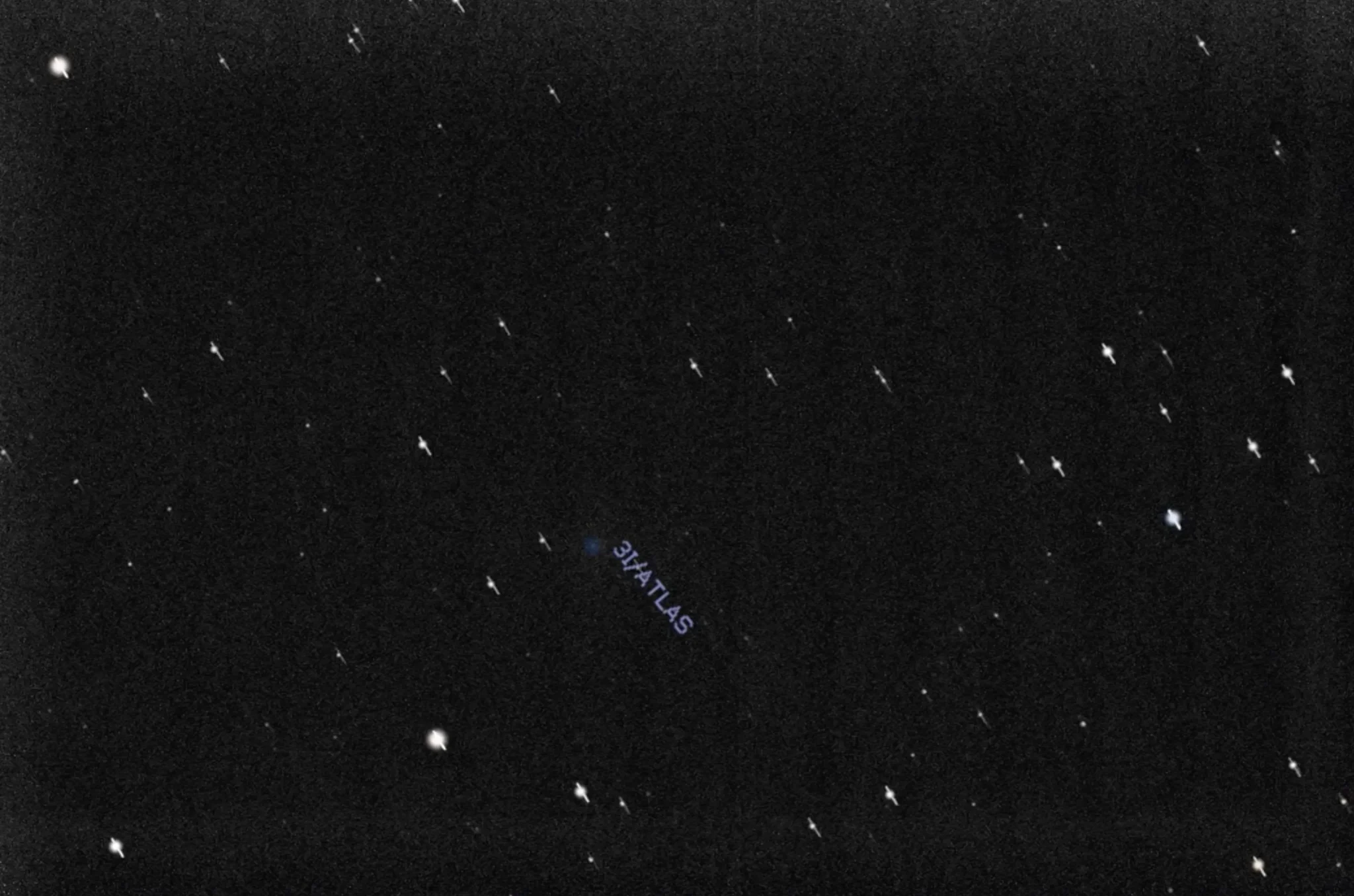
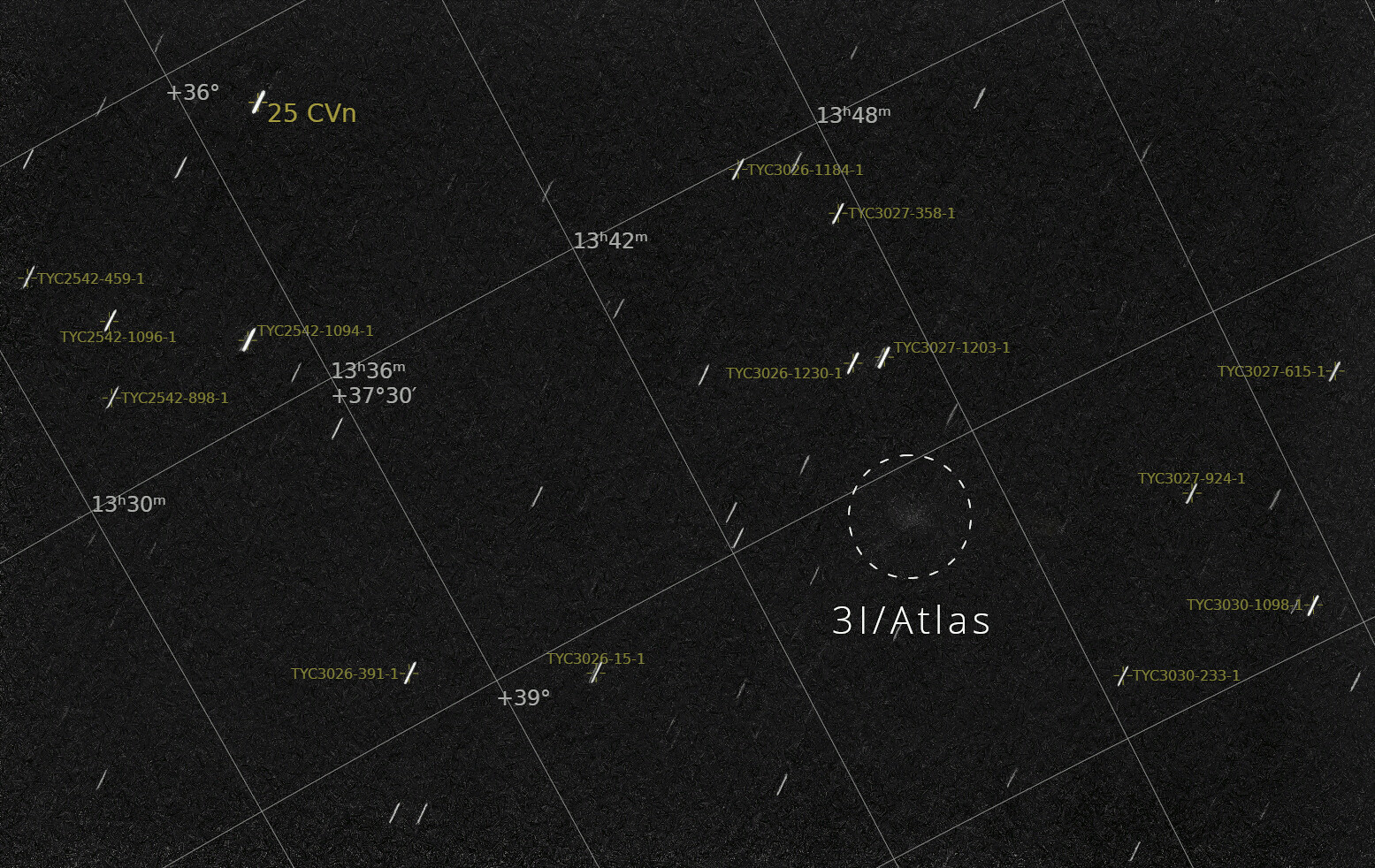
Astronomy enthusiast Simeon Schmauß publishedan image obtained during the processing of photographs taken by the Perseverance rover. It shows the interstellar comet 3I/ATLAS.
Interstellar comet 3I/ATLAS in the Martian sky. Source: NASA/JPL-Caltech/ASU/Simeon Schmauß
On October 3, interstellar comet 3I/ATLAS flew past Mars at a distance of 30 million km. NASA and ESA deployed spacecraft studying the Red Planet to photograph a visitor from another star system. The Perseverance rover was among them. It took a series of images of the Martian sky in an attempt to capture the comet.
Due to the US government shutdown, NASA is currently unable to make any official statements regarding the results of its observations of the comet. However, amateur astronomer Simeon Schmauß used publicly available images of Perseverance to find it. To do this, he processed and stitched together twenty images taken with a 30-second exposure set on the rover’s Mastcam-Z camera.
Interstellar comet 3I/ATLAS in the Martian sky. Source: NASA/JPL-Caltech/ASU/Simeon Schmauß
In the final image, you can see a faint cloud of 8th magnitude. This is the interstellar comet 3I/ATLAS. Despite its relative proximity to Mars, it cannot be seen from its surface with the naked eye. This is because the vicinity of Mars receives 2.5 times less sunlight than Earth. Therefore, the activity of 3I/ATLAS is much lower than it could be if the comet were closer to the Sun. Furthermore, contrary to speculation by ufologists, its core is not particularly large.
Interstellar comet 3I/ATLAS in the Martian sky (annotated version). Source: NASA/JPL-Caltech/ASU/Simeon Schmauß
It is also worth noting that many online resources have begun publishing images taken by Perseverance’s navigation camera, which show a bright elongated object, claiming that this is the interstellar comet 3I/ATLAS, and that the absence of a tail means that it is of artificial origin. However, this is a deception. In reality, these images show Phobos, which was captured in the frame at the moment of shooting. It is bright and moves at high speed across the Martian sky, which creates a “smeared” effect.
An image of Phobos captured by the Perseverance rover’s navigation camera, which is being passed off as a photograph of an interstellar comet. Source: NASA/JPL-Caltech/ASU
Just a reminder that comet 3I/ATLAS will reach the perihelion of its orbit on October 29. At that moment, it will not be visible from Earth. However, it will be observable by the European JUICE spacecraft, which will be in a suitable position for this.
Image of 3I/ATLAS amongst a sea of stars and in isolation. Credit - NOIRLab/AURA/Gemini North/IfA University of Hawaii
Interstellar visitor 3I/ATLAS has been constantly changing as it makes its way through our solar system. That’s to be expected, as, for the first time in potentially billions of years, it's getting close to the energy put out by a star. Scientists have been keeping a close watch on those changes, both to ensure there’s nothing unexplainable by our current understanding, but also to compare 3I/ATLAS to both previous interstellar visitors as well as comets in our own solar system. A recent paper from European researchers describes how the changes in a particular material ratio in 3I/ATLAS’ coma fit with our current understanding of cometary geology.
That ratio is the nickel to iron (Ni/FE) abundance ratio. It has been measured for two decades, including on twenty in-system comets as well as 2I/Borisov, the last known interstellar visitor our solar system had. However, the fact that either of those materials is even present at all in the coma has puzzled scientists, as the temperatures on their surfaces typically aren’t enough to sublimate the silicates or sulfides that are thought to hold these metals on cometary surfaces.
The Ni/Fe ratio from studying 2I/Borisov were similar to those of in-system comets. But that ratio is also about 10 times higher than the Ni/Fe of the Sun itself. So the fact that one of our interstellar visitors and our in-system comets had the same high ratio pointed to some common process in cometary formation that was agnostic to the materials available in the star it formed around.
Fraser answers a bunch of questions about comet 3I/ATLAS.
3I/ATLAS, though, was different, as it has been in so many ways, from both in-system comets and 2I/Borisov. The researchers used the European Southern Observatory’s (ESO’s) Very Large Telescope (VLT) in Chile to watch the comet between August and September, while it was traveling from 3.14 AU to 2.14 AU and started to get increasingly warmed by the Sun.
They noted that the spectral absorption line for nickel captured by the VLT’s UV-Visual Echelle Spectrograph (UVES) was present the entire time. However, the absorption lines for iron only appeared once 3I/ATLAS got within 2.64 AU of the Sun. This discrepancy caused a Ni/Fe ratio much higher than those seen in previous comets, but it was actively changing dramatically as 3I/ATLAS got closer to the Sun. No other study had shown that much of a dramatic change.
It also might explain why there is nickel and iron in the comet’s coma in the first place. Researchers had previously developed a theory that the metals they were seeing were tied to carbonyl groups, forming high volatile organometallic compounds. In that scenario, the nickel would be tied up as nickel tetracarbonyl (Ni(CO)4), and iron would be tied up as iron pentacarbonyl (Fe(CO)5). Both of those organometallic materials have sublimation points low enough to do so when still far from the Sun.
Fraser discusses 3I/ATLAS growing a "tail".
Importantly for this data set, nickel tetracarbonyl has a lower melting point than iron pentacarbonyl, which would explain why there was no iron spectra early in the observational period, but there was later when the comet grew closer to the Sun. The temperature gradient over that journey must have crossed the threshold where iron pentacarbonyl started sublimating, causing the dramatic drop in the Ni/Fe ratio seen in the data. The researchers also found that the amount of nickel production in the coma closely matches the theoretical sublimation rate of nickel tetracarbonyl.
The researchers put forth one other important data point about 3I/ATLAS - it can be classified as a “C2-depleted” comet. That means the ratio of diatomic carbon (C2) compared to the cyanogen radical (CN) in its coma is very small. This classification points to 3I/ATLAS’s “primoridalness”, as it was given that ratio billions of years ago when it was formed, and hints that it was formed in a different part of its home system protoplanetary disc than other, more common comets.
More data is coming out about our third known interstellar visitor on a daily basis. That would likely include more studies of its Ni/Fe ratio as it gets even closer to the Sun, and before it moves out of view for a few months. Expect more papers from as many telescopes and research groups as can find observational time to watch this once in a lifetime cometary visitor.
NASA has gone dark just hours before humans get the closest look at the mysterious object barreling through oursolar system.
The interstellar object dubbed 3I/ATLAS will come within 18 million miles ofMars on October 3, its closest flyby of any planet this year.
Two space probes orbiting the Red Planet, Mars Express and ExoMars, are preparing to take Earth's best picture and closest scans of the strange visitor, which scientists have widely concluded is an unusual comet from a distant solar system.
However, when those readings come in, America's space agency may remain completely silent about what the object really is.
NASA has announced that its official website will not be updated during the government shutdown, which has resulted in thousands of federal employees being sent home without pay.
The shutdown couldn't have come at a worse time, as scientists say Friday's flyby could answer many questions about the mysterious comet, including whether it's actually an object of extraterrestrial origin.
NASA's website has announced that no new updates will take place during the government shutdown when start on October 1
3I/ATLAS will come within 18 million miles of Mars on Friday, and two space probes have already started observing it
'Hopefully, we will learn much more about 3I/ATLAS in the coming days,' Loeb told the Daily Mail on Thursday.
The professor added that both Mars Express and ExoMars started their observations of the object on October 1 and will continue studying it until Tuesday, October 7.
Loeb noted that he's interested in several of the findings the space probes should be able to compile while in such close range to 3I/ATLAS, adding that the readings could determine once and for all whether it's a comet or an artificial structure.
'The image and composition would be the top two findings of interest,' Loeb revealed.
Since its discovery by an amateur astronomer this summer, the prevailing theory has been that 3I/ATLAS is a comet with a chemical composition that is unlike anything created within our solar system.
In September, scientists from Michigan State University announced that 3I/ATLAS was spewing gas or dust into space long before it started approaching our sun, something highly unusual for a distant comet.
Their study in the Astrophysical Journal Letters concluded that this meant it was filled with a unique collection of molecules, including carbon monoxide, an odorless gas often produced by burning wood or fossil fuels.
The interstellar object will make close passes by three separate planets, something Harvard Professor Avi Loeb has declared as highly unusual and possibly a sign of alien influence
A new study found 3I/ATLAS was emitting gases into space long before it got close enough to our sun to melt normal gas and dust seen coming from other comets
Based on earlier scans and photos of the alleged comet, Loeb calculated that 3I/ATLAS may be over three miles long.
However, NASA has noted that it could be as small as 1,444 feet in length, which is still considered a 'city-killer' if it were to strike Earth.
'The new data during the Mars encounter will certainly help in clarifying some of the anomalies of 3I/ATLAS, like its anomalous size and composition, but it will not explain its rare alignment with the ecliptic plane of the planets and rare timing in arriving close to Mars, Venus, and Jupiter,' Loeb explained.
NASA and the European Space Agency have said that Friday's historic meeting over Mars should also clear up questions about the suspected comet's trajectory through space and its physical properties.
High-resolution images and spectral data will provide more information about the object's nucleus, tail, and coma - the bright, fuzzy cloud of gas and dust forming around it.
However, some scientists have already dismissed alternative theories about 3I/ATLAS.
Jonathan McDowell, an astronomer and astrophysicist working at the Harvard–Smithsonian Center for Astrophysics, said: 'It is clearly a natural comet; suggestions to the contrary are laughed at by people who are actual comet experts.'
New extraordinary images of the interstellar object flying through our solar system have been released, sparking fresh theories about its origins.
Although most scientists have concluded that the mysterious object is a comet, NASA's Perseverance rover on the Martian surface sent back photos showing what appears to be a massive cylindrical shape.
Stargazers on social media shared color-enhanced images of the object, dubbed 3I/ATLAS, which showed the interstellar visitor having a green glow as it passed Mars and heads closer to the sun.
Harvard astrophysicist Avi Loeb, who has been convinced that the object could be an alien craft or probe, analyzed the Perseverance rover's photos by calculating its distance, speed, and camera settings.
According to his initial study, Loeb was not convinced 3I/ATLAS is actually a massive cylindrical object, noting that the strange shape might have been a trick of the rover's camera stretching out its shape.
He explained that the apparent cylinder from the rover's 'Navcam' was likely caused by the camera stacking hundreds of images of 3I/ATLAS over a period of about 10 minutes, making it look more like a log than a ball.
The professor added that 3I/ATLAS is likely smaller and rounder, but still massive, with a potential diameter of more than 28 miles across.
Dr Horace Drew, a retired senior researcher at Australia's Commonwealth Scientific and Industrial Research Organization (CSIRO), noted that the mysterious green glow seen in some images could be a result of the object being an interstellar spacecraft coated in nickel.
The Perseverance rover on Mars captured new images of the interstellar object 3I/ATLAS as it passed by the planet this weekend
Color-enhanced images shared by multiple social media users revealed a strange green glow around 3I/ATLAS
Drew explained that humans use the same practice on Earth-made space technology on a much smaller scale.
'It is not a 'comet,'' Drew declared on a post on X Monday morning.
Drew disagreed with Loeb's conclusion that the cylindrical shape was a result of the Mars rover sending back a stretched image over several minutes, claiming that an amateur astronomer on Earth captured a similar shape with their telescope.
Drew, who earned his PhD in chemistry from the California Institute of Technology, added that previous images of the interstellar object were allegedly from a 'head-on view' and didn't capture its shape from the side, like the new photos from Mars.
Loeb said he's excited about another image taken by a different Mars camera, called HiRISE, which has better resolution and could show 3I/ATLAS more clearly.
That image is being sent back to Earth by the Mars Reconnaissance Orbiter (MRO) and has yet to be released by NASA.
Loeb has previously theorized that 3I/ATLAS could be a second craft sent by an extraterrestrial intelligence, following the strange cylindrical object known as Oumuamua, which passed Earth in 2017.
3I/ATLAS came within 18 million miles of Mars on October 3. Two space probes from Earth have been observing it for a week
Dr Horace Drew said an amateur astronomer's photo of the 3I/ATLAS (bottom 3 images) prove the object has a cylindrical shape and is not a comet
Loeb told the Daily Mail on Thursday that clear images and a scan of the supposed comet's composition were the key findings that could definitively tell scientists what 3I/ATLAS is.
Despite images emerging from NASA, space agencies around the world have still not commented by their initial findings from the Mars flyby.
Daily Mail reached out to NASA for comment and received a message noting that the space agency 'is currently closed due to a lapse in government funding.'
The European Space Agency (ESA) used the Mars Express and ExoMars Trace Gas Orbiter to successfully observe 3I/ATLAS, but it's expected to take days or even weeks to process all the data.
Meanwhile, some on social media have claimed that the global silence surrounding 3I/ATLAS adds proof that governments are covering up what they know about the alleged craft.
'NASA's shutdown is suspicious. The ESA's delay is strange. But China's silence, when they have every geopolitical reason to publish and show off, is the sign that something is happening behind closed doors,' one X user said on Monday.
'All eyes are on 3I/ATLAS — but suddenly, the silence is deafening,' another person posted.
Supermassive Black Hole or Galactic Consciousness?
Astronomy news sources, these days, state in a matter-of-fact manner that the centers of galaxies harbor supermassive black holes, which emit vast quantities of electromagnetic energy and high-speed plasma jets that power the entire galaxy. This is the reason why supermassive black holes are regarded as the “central engines” of galaxies.
However, when we delve a bit deeper into the observational data, we find that there is little evidence that the high-energy physics that is associated with the cores of galaxies has any relation to the “black holes” that came out of Einstein’s equations.
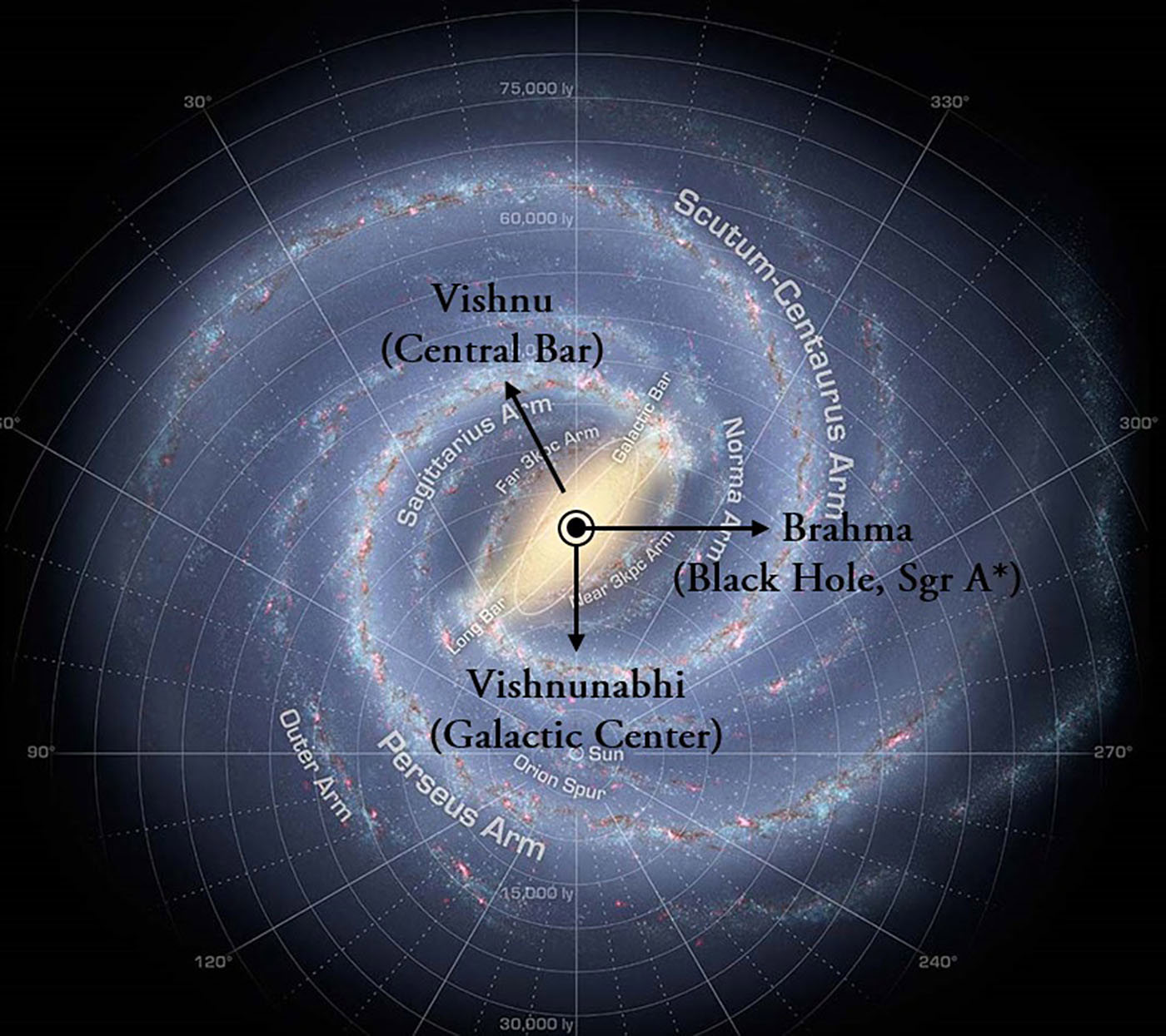
When I was writing Yuga Shift, I had used the term “black hole” to refer to the cosmic entity that generates the powerful energetic emissions from the Galactic Center. However, that does not mean that I was convinced that the galactic core is, indeed, a black hole. In fact, when we look back at how the idea of black holes originated from Einstein’s equations, and how they were expected to behave, it becomes obvious that galactic cores simply do not behave in the manner that is expected of a black hole. Something else is going on, and scientists seem to have no clue as to what it is.
What are Black Holes?
American physicist Michio Kaku, in his lucidly written book, Parallel Worlds,[1] has provided an illuminating look into the origins of the world of black holes.
It all began in the year 1916, when Karl Schwarzschild, a German physicist serving in the German army on the Russian front, found a weird solution to Einstein’s equations for a large star. He calculated that, if an object the size of our Sun were to be compressed down to 2 miles, it would turn into a “dark star” and its gravity would be so powerful that not even light could escape from it. If any object crossed the “Schwarzschild radius” or “event horizon” of this dark star (which is the radius of the dark star i.e., 2 miles in this example) it would get sucked into the star, never to be seen again.
Interestingly, Einstein never liked the idea of a dark star or a “singularity” where gravity becomes infinite and the laws of physics cease to operate. In a paper authored in 1939, he posited that dark stars cannot be formed by natural processes. “The essential result of this investigation is a clear understanding of why the “Schwarzschild singularities” do not exist in physical reality,” he wrote.
Unfortunately, Einstein’s opinion did not prevail in this matter. Robert Oppenheimer – the father of the atomic bomb - and his student proposed an idea that caught the fancy of other physicists. They said that an old massive star that has used up its nuclear fuel could implode under the force of its gravity and get compressed within its Schwarzschild radius. “Black holes, they suggested, were not only possible, they might be the natural endpoint for billions of dying giant stars in the galaxy.”
All of a sudden, black holes became ubiquitous celestial objects, with countless numbers of them lurking unseen in every cosmic neighborhood like giant, open manholes, waiting patiently to suck in an unsuspecting cosmic voyager into their dark underbelly, never to return again to the world of light.
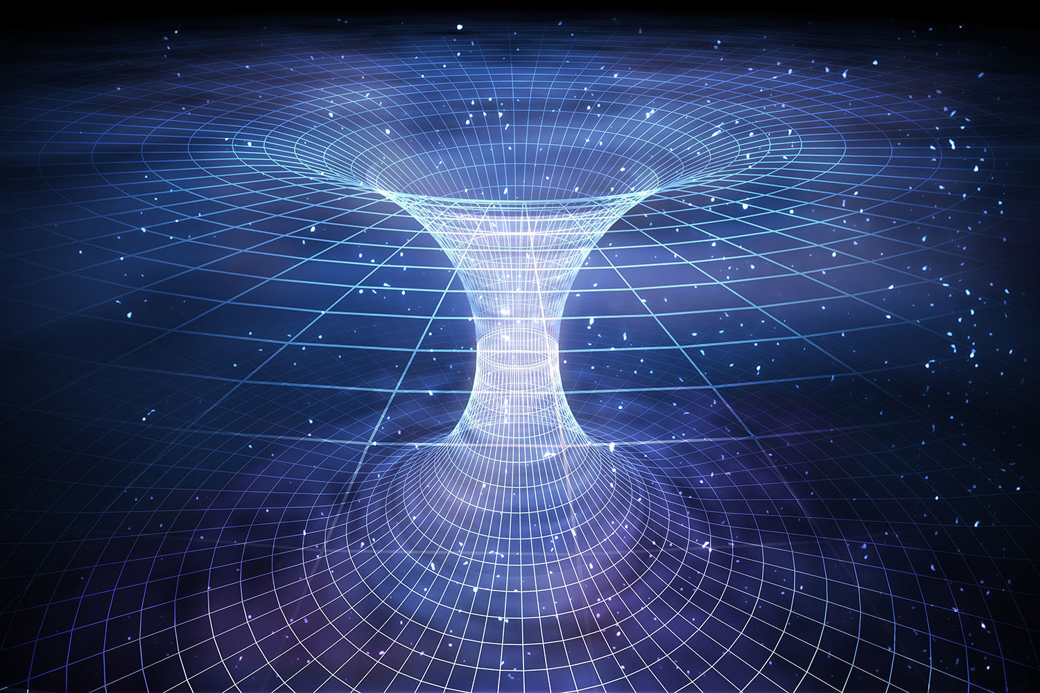
In 1963, New Zealand mathematician Roy Kerr added another weird attribute to this enigmatic object. He proposed that, as a star collapses under gravity, it will spin faster to conserve its angular momentum. A spinning star will collapse into a “ring of neutrons,” which would remain stable due to the centrifugal force pushing outward. Thus, if you fell into the Kerr black hole, you would not be crushed. Instead, you will be transported through a “wormhole” to a parallel universe.
“Pass through this magic ring and – presto! – you’re in a completely different universe where radius and mass are negative!” Kerr exclaimed to a colleague.
Figure 1: A wormhole leading from a black hole to another universe. Source: Adobe Stock
Thus, black holes came to be visualized as a dark star with enormous gravitational pull, which was formed when a dying star imploded under its own gravity and got compressed within its Schwarzschild radius. Its gravitational force is so powerful that it sucks in any matter passing near its event horizon, either crushing and transforming it or transporting it via a wormhole to a radically different universe.
In spite of all the mathematical wizardry that went into its formulation, till around the 1990s, most astronomers regarded black holes as science fiction. But things began to change with the discovery of Sgr A*, the powerful radio source at the heart of the Milky Way.
A Supermassive Black Hole at the Galactic Center?
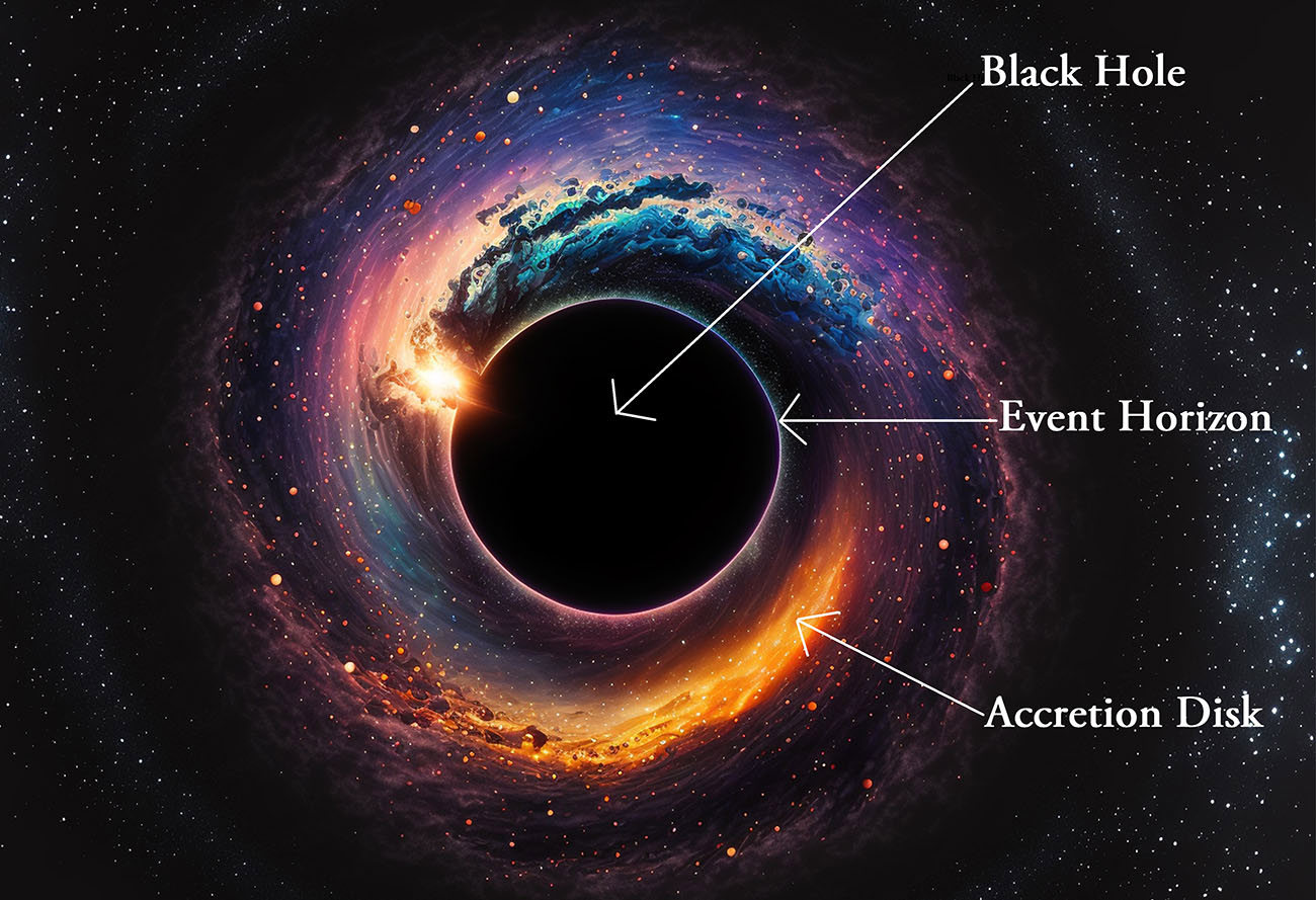
For a long time, astronomers had been observing a powerful radio source at the center of the Milky Way, which they termed Sgr A*, since the radio source was located in the direction of the Sagittarius constellation. They began to think that the only cosmic object that could generate such powerful radiation in the radio frequency (RF) is a black hole. It was proposed that Sgr A* could be a supermassive black hole, nearly 4.3 million times the mass of the sun, squeezed into a tiny space only ten times bigger than the sun.
Astronomers further speculated that when the nuclear bulge was forming, a small fraction of the mass lacking orbital momentum collapsed in the middle to form the supermassive black hole. The radio waves from Sgr A* are not coming from the black hole itself, they said, but from the “accretion disk” that surrounds the black hole. The accretion disk was believed to consist of rings of superheated hot gas, dust and stars that surround a black hole and spiral towards the event horizon, being pulled by the powerful gravity of the black hole.
Subsequent observations of many other galaxies, including our own, revealed that galactic cores are not only emitting intense electromagnetic radiation at all frequencies – from radio waves to gamma rays – but they are also ejecting relativistic plasma jets from their north and south poles.
Figure 2: A Schematic of a black hole. Source: Adobe Stock.
As time went on, and more observational data came in, however, it was noticed that Sgr A* was not behaving as expected of a black hole. But, since no one seemed to know that Sgr A* could otherwise represent, astronomers stuck to the same story. And as it happens so often in science, a faulty hypothesis turns into a theory simply by virtue of repetition, and all the anomalies are quietly filed away.
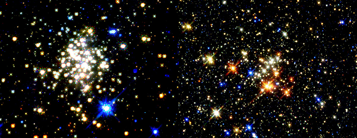
So what are the anomalous behaviors of Sgr A* that undermine the supposition that it is a black hole? Firstly, astronomers always said that the region near the center of the galaxy, close to Sgr A*, would be too volatile for active star formation, due to the tremendous gravitational pull of Sgr A*. But when they got a good, hard look into the region of the Galactic Center with Hubble's NICMOS infrared camera, they found that,
“The Galactic Center is a hotbed of star formation activity, containing the most massive star formation site and three of the most massive young star clusters in the galaxy.”[2]
This is the exact opposite of what had been posited by scientists! The region of the Galactic Center is a prolific site of star formation, not at all what you would expect if a monstrous black hole were lurking nearby and trying to rip apart the clouds of gas and dust. But this anomaly did not deter our perseverant astronomers. It was just an oddity that needed to be handled later, perhaps when the stars were perfectly aligned.
It’s quite stunning how big and dense the star clusters in the Galactic Center are. A Hubble Telescope image of a pair of star clusters called Arches and Quintuplet, located less than 100 light-years from the center of our galaxy, shows that the clusters are 10 times larger than typical young star clusters scattered throughout the Milky Way galaxy. The Arches cluster is so dense that over 100,000 stars will fit into the space between our sun and its nearest neighbor, the star Alpha Centauri, 4.3 light-years away. Only 1 out of every 10 million stars in the galaxy is as luminous as the Arches cluster stars. At least a dozen of the stars weigh about 100 times the mass of our sun.[3]
In other words, the stars near the Galactic Center are much bigger, far more luminous, and a lot more densely packed than those found in the spiral arms.
Figure 3: Hubble Telescope image of a pair of dense star clusters, less than 100 light-years from the center of our galaxy. Credit: NASA and STSI, Public Domain Image.
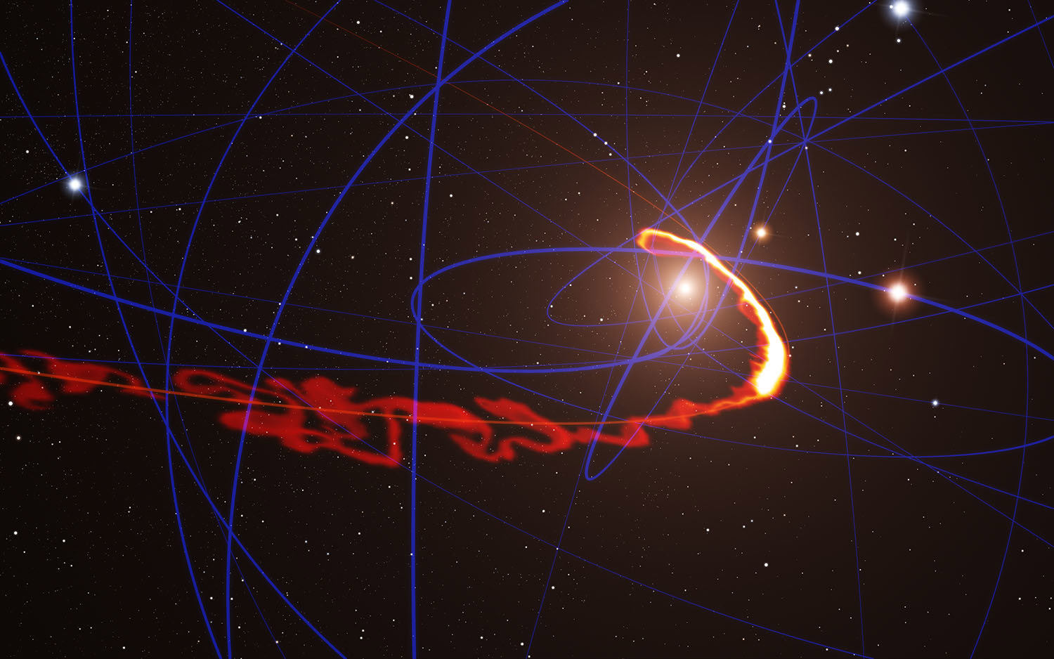
The other claim that astronomers had made about Sgr A* is that it must be gobbling up passing stars and molecular clouds on a routine basis, and whenever it does so, it emits powerful X-ray flares. But, despite careful observations over long periods of time, Sgr A* has never been seen to suck in nearby matter. One example stands out from the rest, thanks to all the hullabaloo that was generated in the years leading up to the grand non-event.
In 2011, astronomers discovered a cloud of gas termed G2, heading towards Sgr A*. It was predicted to pass within about 36 light-hours of the black hole in 2014 and be tidally disrupted, causing much of its material to accrete onto Sgr A*, thereby causing a bright X-ray outburst. Guess what happened? Nothing! To the utter shock of astronomers - who were eagerly observing Sgr A* like a bunch of kids gathered around an aquarium during shark feeding time - G2 wafted past Sgr A*, and continued merrily along its orbit, without even pausing to exchange courtesies. Needless to say, the much-anticipated fireworks of X-ray emissions from Sgr A* did not happen either.[4]
But did this little setback inspire our astronomers to revisit the hypothesis that Sgr A* is a black hole? Of course not! Why would you topple a perfectly good story for want of corroborating data and get into everyone’s bad books? That’s a sure shot way to get your telescope time taken away from you.
Figure 4: Simulation of the gas cloud G2 passing close to Sgr A* in 2013. Credit: ESO/S. Gillessen/MPE/Marc Schartmann, Public Domain
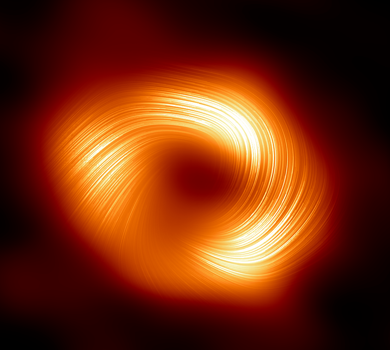
Astronomers had also contended that the powerful electromagnetic emissions from Sgr A* are being emitted by the “accretion disk” around the black hole. But new observations reveal that Sgr A* does not even have an accretion disk! Instead, it is encircled by strong and organized magnetic fields, which sustain filaments of gas. This is consistent with observations from other galaxies as well.
In 2008, astronomer Andrew Fabian of Cambridge University in the UK, looked at the Hubble Telescope images, and found that, “Long-lived magnetic fields are sustaining a mammoth network of spaghetti-like gas filaments around a black hole…at the heart of a large galaxy known as NGC 1275.”[5]
In 2015, the Event Horizon Telescope detected magnetic fields just outside the event horizon of Sgr A* at the center of the Milky Way galaxy. A report by the Harvard-Smithsonian Center for Astrophysics published in ScienceDaily states,
“Most people think of black holes as giant vacuum cleaners sucking in everything that gets too close. But the supermassive black holes at the centers of galaxies are more like cosmic engines, converting energy from infalling matter into intense radiation that can outshine the combined light from all surrounding stars…For the first time, astronomers have detected magnetic fields just outside the event horizon of the black hole at the center of our Milky Way galaxy...In the case of Sgr A*, polarized light is emitted by electrons spiraling around magnetic field lines. As a result, this light directly traces the structure of the magnetic field…The team found that magnetic fields in some regions near the black hole are disorderly, with jumbled loops and whorls resembling intertwined spaghetti. In contrast, other regions showed a much more organized pattern.”[6]
In March 2024, the Event Horizon Telescope (EHT) collaboration unveiled a new image of Sgr A* in polarized light, which revealed strong, twisted, and organized magnetic fields near the edge of Sgr A* in the center of the Milky Way galaxy, very similar to that seen around the M87* black hole.[7]
Figure 5: An image of Sgr A*, the central black hole of the Milky Way, in polarized light, showing the organized magnetic fields around it. Image Credit: EHT Collaboration, Public Domain.
So, instead of an accretion disk, Sgr A* is encircled by strong, twisted, organized magnetic fields, which, quite possibly, support filaments of gas. Therefore, the EM radiation and plasma jets cannot be coming from an accretion disk surrounding a black hole. They must be emitted by Sgr A* itself!
It should be evident from these observations that Sgr A* bears no similarity to the black hole that came out of Einstein’s equations. Not only does it not gobble up nearby matter by means of its gravitational force or disrupt star formation in regions close to it, it does not even have an accretion disk. Moreover, Sgr A* emits enormous amounts of EM radiation and plasma jets, while a black hole was visualized as a dark star from which nothing ever came out, not even light.
Which brings us to an important question: If Sgr A*, the galactic core, is not a black hole, then what could it be?
If we go by the observational data, then Sgr A* appears to be functioning as the “central engine” of our galaxy. It could be drawing in matter from the rest of the galaxy (or even from outside it) through filaments of gas, which are supported by powerful magnetic fields, and transforming this matter into EM radiation and plasma jets to support galactic functions. Which means, Sgr A* must be imbued with a “cosmic intelligence” that allows it to know what needs to be done to support, organize, and regulate our galaxy.
It would not be amiss to argue that Sgr A*, the galactic core, is the central, creative, and organizing consciousness of our galaxy. It is this galactic soul or galactic consciousness that orchestrated the evolution of our galaxy over eons and continues to regulate its vital functions. All the high-energy physics that we see around it is the manifestation of this consciousness. We are observing consciousness in action, but we are unable to recognize it as such, since we don’t have the mathematical tools to describe consciousness, nor do we have a well-established reference point to compare it against.
Interestingly, many ancient cultures knew about the central organizing consciousness of our galaxy, and referred to it in their texts and traditions as the Supreme Creator or Great Spirit. Their descriptions of this ultimate creative entity resonate with what has been discovered about Sgr A* till now. Let me begin with the Vedic descriptions of the unformed, creative spirit known as Brahma, and then I will move on to other religious and spiritual traditions, which have a similar philosophical outlook.
Sgr A* - The Galactic Consciousness
The Vedic sages believed that our world was brought forth by the supreme creative principle Brahma, who exists in an unformed, unmanifested state at the “navel of Vishnu,” i.e., Vishnunabhi; whereas, Vishnu, the god of preservation, was said to recline in the “middle of the cosmic milky ocean” on his serpent couch.
In Yuga Shift and prior articles, I had contended that the enormous central bar of our galaxy, which stretches across the middle of our galaxy for nearly 27,000 light-years, is what the Vedic sages knew as Vishnu, while the “navel of Vishnu” or Vishnunabhi – around which our sun revolves, as Sri Yukteswar had claimed - is the Galactic Center, since the navel is the center point of the human anatomy, and we also know that our sun revolves around the Galactic Center.
The only cosmic entity in the vicinity of the Galactic Center deserving of the epithet Brahma, the unmanifested creative spirit, is Sgr A*, which astronomers believe is a supermassive black hole.
Figure 6: The Milky Way galaxy has a long central bar, which the Vedic sages knew as Vishnu; the region of the Galactic Center was the “navel of Vishnu” or Vishnunabhi; while Sgr A*, the central black hole, was Brahma, the creative spirit. Adapted from an image by NASA/JPL-Caltech/R. Hurt, Public Domain.
As per the Vedic texts, Brahma is the unformed spirit who brings forth the world of forms. He is the eternal, omniscient consciousness, who multiplies himself and lives in the heart of all living beings as their immortal soul. What this implies is that Sgr A*, the galactic soul or galactic consciousness, produces small “packets of consciousness” that we call the soul or self, which animates all life.
In other words, all souls emanate from Sgr A* and return there after the completion of their reincarnation cycles. The Vedic texts also tell us of a very long cycle of time called the “Day of Brahma” (spanning 12.9 million years), following which there is a cosmic reset. This is when Brahma withdraws all souls back inside himself, and the entire galaxy becomes lifeless for another 12.9 million years, which comprises the “Night of Brahma”. Consider the following hymns from the collection of Vedic texts called the Upanishads, which elucidate these ideas.
“In the beginning was only Being (Brahma), One without a second. Out of himself he brought forth the cosmos and entered into everything in it. There is nothing that does not come from Him. Of everything, He is the inmost Self.”8 (CU 6.2.2) “The ruler Supreme (Brahma), inner Self of all, Multiplies his oneness into many.”9 (KU 2.2.12)
“He (Brahma) is the inner ruler in all beings. He projects the cosmos from himself, maintains and withdraws it back into himself at the end of time.”10 (SU 3.2)
This is the basic understanding of the Vedic philosophical tradition: “The Atman (i.e., individual soul) is Brahma (i.e., Universal Soul)”. Our soul is of the same essence as the Creator, and therefore, our bodies are the sacred Temple of God. In order to find joy and fulfilment, we need not search around aimlessly in the world, but tap into our inner divine essence, i.e., our self or soul, which is the repository of love, bliss, joy, contentment, truth and wisdom. Those who can do this break free from the reincarnation cycle.
“Wherever the mind wanders, restless and diffuse in its search for satisfaction without, lead it within; train it to rest in the Self. Abiding joy comes to those who still the mind.” (BG 6.26-27) “He (Self) is formless, and can never be seen with these two eyes. But he reveals himself in the heart made pure through meditation and sense-restraint. Realizing him one is released from the cycle of birth and death.” (KU 2.3.9)
The Vedic texts also tell us that, when a person exits the reincarnation cycle on attaining self-realization, he returns to the Brahmaloka or Brahma-world, where he dwells for immortal years in bliss and love, free of grief or suffering. If Sgr A* is Brahma, the galactic soul, then the Brahma-world or Brahmaloka is likely to be the effulgent central bulge of our galaxy, i.e., the galactic nucleus, which contains Sgr A* in its center.
In other words, the Milky Way’s nucleus is the heavenly domain of the primordial Creator, the “paradise in the center of the world” that so many ancient traditions speak of, where the sages and virtuous souls dwell in eternal bliss. This was the exalted afterlife destination sought by the saints of the past. Thanks to our ever-evolving awareness of the universe, it is now becoming possible to bring these esoteric concepts out of the metaphysical realm and relate them to a tangible, physical reality.
As to what Sgr A*, the galactic consciousness, may be composed of is, of course, hard to guess. The Bhagavad Gita, the spiritual poem of India, provides some clues to the nature of the soul or self, which is of the same essence as Brahma, the galactic consciousness. The poem states,
"The Self cannot be pierced by weapons or burned by fire; water cannot wet it, nor can the wind dry it. The Self cannot be pierced or burned, made wet or dry. It is everlasting and infinite, standing on the motionless foundations of eternity. The Self is unmanifested, beyond all thought, beyond all change.” (BG 2.23-25)[11]
What we can gather from these descriptions is that the soul or self is likely to be made up of an invisible, exotic form of energy, which does not react with other types of energies or matter, and therefore, it cannot be dissipated or transformed, although it is capable of making copies of itself. This energy is aware, intelligent, and capable of storing massive amounts of information, and is completely unlike any other form of energy.
The Judaic philosophy has similar thoughts about the cosmos and the nature of souls. In the book, Tree of Souls: The Mythology of Judaism, Howard Schwartz writes that all souls in Paradise are stored in a “Treasury of Souls” or Guf, until it is time for them to be born into this world. Regarding the “Treasury of Souls”, which is also called the “Chamber of Creation”, Howard says that it is located,
“In the highest heaven, known as Aravot...The Guf is found near the Throne of Glory, and a dazzling brilliant light emanates from the many souls in repose there. Those souls are in their pristine state, untainted by existence in this world. Some of them flicker like a small candle and some shine like a torch, and there are some whose radiance rivals the sun… When the time comes for it to descend into this world, an angel is issued along with it, who accompanies it...As soon as the soul leaves the Guf, it divests itself of its heavenly garment, and is clothed in a garment of flesh and blood.”[12]
Judaic philosophy further states that once a soul has been born in this world and is tainted by its sins, it is extremely difficult for it to go back to Paradise, the original place where it was born. “Those who stray from there, exiled into the fallen world, eventually find themselves naked and in need of repair by the field master...For even the greatest soul has difficulty reentering the field once it has departed.”[13]
I would argue that the “Treasury of Souls” or “Chamber of Creation” in Judaism refers to the central bulge or galactic nucleus, also called Paradise or the highest heaven, Avarot. Since the “Treasury of Souls” is said to be located near the “Throne of Glory”, i.e., the seat of God in Paradise, my interpretation is that Sgr A*, the galactic soul or galactic consciousness, is the “Throne of Glory” in Judaism.
The “Treasury of Souls” or the galactic nucleus is also the original Garden of Eden, where the soul of man was fashioned, and where he lived in eternal bliss until he was exiled from Paradise and sent to the fallen world outside; and it is only after he has regained his original purity and attained self-realization, can he return to the galactic nucleus.
The Judaic doctrine makes an interesting statement about the newly born souls that are kept in the “Treasury of Souls”. It states that a brilliant light emanates from the many souls in repose there. Some of them flicker like a small candle, and some shine like a torch, and there are some whose radiance rivals the sun.
Let’s recall here that most ancient societies believed that the souls of their ancestors appeared as “stars” in the sky. Therefore, going by this Judaic doctrine, the central bulge should contain faint, young stars in addition to massive, brilliant ones. Isn’t that exactly what scientists have found in recent years – that, in proximity to Sgr A*, intense star formation activity is going on, and massive young star clusters are present there, containing stars that are bigger and brighter than our sun?
It’s amazing how things begin to fall in place and make sense, and esoteric doctrines reveal their secrets, once you find a clue to the whole mystery. A lot of observational data about our galaxy and the universe has been amassed over the past few decades by astronomers, and when we try to correlate them to the information in the ancient esoteric and cosmological doctrines, we can arrive at surprising realizations.
Christian mysticism - such as Franciscan mysticism – speaks of the “Eternal, Cosmic Christ” or the “Christ Consciousness”, which activates the heart center and inspires men and women towards oneness with all of creation. But who or what is the “Eternal, Cosmic Christ”, many have wondered? Before attempting to answer that question, let’s remember that “Christ” was not Jesus’s last name. It was a title given to Jesus. The term Christ derives from the Greek word Christos, which means “Anointed One” or “Messiah”. The term Christos precedes Jesus and the Christian religion by millennia, and was typically given to someone who was perceived to be a human incarnation of the “Eternal, Cosmic Christ,” i.e., someone who has willingly descended on the mortal plane to guide the suffering humanity to salvation.
I believe that it is Sgr A*, the galactic soul or the galactic consciousness, whom the Vedic sages revered as Brahma and the Hebrews called the “Throne of Glory”, that is the “Eternal, Cosmic Christ” or the “Christ Consciousness”. It is from this Source that all souls are born into this world; they return to the Source after attaining liberation. The liberated beings who dwell in the galactic bulge – such as Jesus or Buddha - can willingly reincarnate on earth from time to time as the teachers and guides of humanity.
Jesus often referred to this galactic soul as his “Father” in heaven, since all souls emanate from it. When he told his disciples that, “If you loved me, you would be glad that I am going to the Father, for the Father is greater than I,”[14] he was, in all likelihood, talking about returning to the galactic nucleus, which was the Paradise in the center of the world and the original Garden of Eden.
Figure 7: The brilliant central bulge or galactic nucleus of the Milky Way galaxy. This was the afterlife destination of saints, the paradise at the center of the world, and the original Garden of Eden. Source: Adobe Stock
It is well-known that the Greeks had an enviably large pantheon of gods. But there was also a prevailing belief that all life derives from a single, omniscient Source, which is fixed in space and regulates all affairs by the power of its mind. The earliest account of such a Supreme Being comes to us from a travelling poet and sage of ancient Greece called Xenophanes of Colophon, who lived in the 6th century BCE. There are 45 surviving fragments of his poetry, which offer glimpses into the fundamental tenets of his philosophy. Some of the extant fragments describe the Supreme God:
“One god is greatest among gods and men, Not at all like mortals in body or in thought. (frag. 23) …whole he sees, whole he thinks, and whole he hears. (frag. 24) …but completely without toil he shakes all things by the thought of his mind. (frag. 25) …always he abides in the same place, not moving at all, nor is it seemly for him to travel to different places at different times. (frag. 26)”[15]
The Supreme Being described by Xenophanes is “not at all like mortals in body,” i.e. not made up of matter, “always abides in the same place”, and “shakes all things by the thought of his mind.” These attributes have obvious correlations with Sgr A*, the galactic consciousness, for Sgr A* is not made up of matter, remains fixed in the center of the galaxy, and it regulates all galactic functions by means of its powerful energetic emissions.
In Cicero’s Prior Academics, there is a passage claiming that the eternal, unchanging One God is spherical in shape. This strengthens the association of the One God with Sgr A*, which is a spherical cosmic entity:
“(Xenophanes said that) all things are one, that this is unchanging, and is god, that this never came into being and is eternal, and has a spherical shape.” (2.18)[16]
In many Native American tribes, the supreme creative spirit was known as the Great Spirit or Great Mystery, which, I believe, also refers to Sgr A*, the galactic consciousness. The Great Spirit was known by different names by different tribes – such as Wakan Tanka in the Lakota tradition or Gitche Manitou in the Algonquian tradition - but in all cases, the overarching beliefs were the same: that the Great Spirit was the Supreme Being, who infused everything with a life force or soul. He is the Creator who lives in all of us. Chief Luther Standing Bear (1868–1939) of the Lakota Nation explained it eloquently:
“From Wakan Tanka, the Great Spirit, there came a great unifying life force that flowed in and through all things – the flowers of the plains, blowing winds, rocks, trees, birds, animals – and was the same force that had been breathed into the first man. Thus all things were kindred, and were brought together by the same Great Mystery.”[17]
In some cultures, the name of the Creator revealed his location in space. For instance, in the Popul Vuh, which recounts the mythology and history of the K’iche Maya people of Guatemala, the Creative Spirit is called Huracan, the Heart of Heaven. It is Huracan who dreams the world into existence in the darkness of the night and breathes life into all creatures. The term “Heart of Heaven” is not incompatible with Sgr A*, the galactic consciousness, which lies in the heart of the Milky Way.
Another example is the foundational figure of Shinto creation myths, called Ame-no-Minaka-Nushi-no-Mikoto, whose name translates as “Deity of the August Center of Heaven”. The Kojiki portrays him as the first deity to appear during the creation of the world. He was the divine source from which the later kami (gods) originated. Incidentally, Ame-no-Minaka-Nushi-no-Mikoto hid his form upon coming into existence. This is consistent with our understanding of Sgr A*, which is not only hidden from our view (only its outline is visible using sophisticated telescopes) but is also located at the cosmic center.
Evidently, many ancient conceptions regarding the Supreme Being have a strong correlation to what we know about Sgr A*, the galactic core. The connections are striking and persuasive. It isn’t far-reaching to propose that we live in a conscious, living galaxy that is constantly creating, growing and transforming. This is not a new idea by any means. The sages and philosophers of antiquity believed that the heavenly bodies, such as the sun, moon, and the planets, were imbued with souls and intelligences. The currently used scientific term for this belief system is panpsychism, which posits that consciousness is a fundamental and ubiquitous feature of our reality.
The Conscious Sun
A well-known proponent of panpsychism is British author and biologist Rupert Sheldrake, who believes that the Sun’s complex electromagnetic rhythms might be indicative of a form of awareness.
In a paper titled, “Is the Sun Conscious?”[18] Sheldrake argued that, “nervous systems in general, and brains in particular, function electromagnetically.” Within the brain, rhythmic patterns of electrical activity emerge from the activities of countless neurons - such as alpha waves, theta waves, and gamma waves - which can be measured through electrodes placed on the skull, as in electroencephalographs (EEG). These electrical waves set up oscillating magnetic fields.
Sheldrake referred to various studies in the “field theory of consciousness”, all of which agree that consciousness is related to the electromagnetic activity of the brain. Some researchers have gone further and proposed that the brain’s electromagnetic fields actually are conscious. According to John Joe McFadden, “the brain’s EM field is in fact the physical substrate of consciousness, and conscious volition results from the influence of the brain’s EM field on neurons that initiate motor actions.”
Now, the sun is an extraordinarily complex electromagnetic system, whose effects permeate the solar system. The movements of electrified plasma on the solar surface create a magnetic field, which extends throughout the body of the sun to the limits of the solar system. The changing magnetic fields within and beyond the sun give rise to electrical currents in the plasma. During times of solar maxima, there are many sunspots on the solar surface from where extraordinarily strong magnetic fields emerge from the sun’s interior, loop around above the photosphere, and re-enter the sun through spots of opposite magnetic polarity. Sometimes these extraordinarily powerful loops of magnetic energy break and rejoin, emitting enormous amounts of energy in the form of solar flares and coronal mass ejections.
Figure 8: A Coronal mass ejection (CME) erupted on the Sun on 31 August 2012 and caused auroras to appear on Earth three days later. Credit: NASA Goddard Space Flight Center, Public Domain Image.
Sheldrake argued that, if the electromagnetic activity of the brain is indicative of a conscious mind, “then the electromagnetic activity of the sun may well be the principal interface between the physical activity of the sun and the solar mind… The mind of the sun, though centered in the sun itself, may integrate information from the entire heliosphere, just as our minds, centered in brains, integrate information from our own bodies and the world around us.” Sheldrake, then, went on to speculate what would be the principal preoccupations of the solar mind:
“The sun would be able to sense what is going on throughout the solar system through the electromagnetic field that pervades the heliosphere, which could act as its primary sense organ. Thus, the sun’s mind could, in principle, know about all events within the solar system… In the first place, the sun is presumably concerned with the regulation and preservation of its own body, the sun itself, and its extended body, the solar system, right out to the heliopause… influencing it through the intensity of the solar wind, through directional solar flares, and most dramatically through coronal mass ejections pouring billions of tons of charged particles towards anything in their path… Secondly, the sun may be aware of its position and interactions with other stars and solar systems in its immediate neighborhood, and ultimately throughout the entire galaxy. These systems may in turn be part of a galactic mind, like neurons within a galactic brain. They are literally interconnected through the plasma permeating the arms of the galaxy, through which vast electric currents flow, spiraling around enormous magnetic field lines radiating out through the galactic arms that are tens of thousands of light years long. The sun is part of a vastly greater electromagnetic system… At the center of our galaxy is a supermassive black hole that emits huge amounts of energy, with a galactic wind passing along the spiral arms extending outwards from it...The sun is influenced by the electromagnetic patterns of activity within the galaxy as a whole, which could in turn be closely connected with a galactic mind, perhaps centered in or around the supermassive black hole at the galactic center. The galactic mind could influence what happens here on earth through its effects on the sun and the solar mind.”
Sheldrake’s proposition that the activities of the conscious sun may be regulated by a “galactic mind” centered in the supermassive black hole at the galactic center is very similar to what I have proposed - except that I now no longer believe that there are any black holes. Every so-called black hole is a galactic soul. Remember that Sgr A* is enclosed by “strong, twisted, and organized magnetic fields”, and as per the field theories of consciousness, Sheldrake presents in his paper, EM fields are associated with consciousness.
Soul Consciousness
There is another thing that I need to discuss here. Sheldrake talks about the EM field of the brain and posits that this EM field is the means through which the brain senses the nerve stimuli and carries out its conscious actions. But the human heart also generates a very powerful EM field, which is 5000 times more powerful than the brain’s EM field. The heart's energy is said to reach about three feet outside of the physical body and can be detected in another person sitting nearby via an electrocardiogram (ECG).[19]
Figure 9: The magnetic field of the heart reaches 3 feet outside the body. Source: Adobe Stock
This means consciousness also resides inside our heart, and it is this consciousness that the ancients called the self, soul, or soul consciousness. It is the soul that is the source of the mind and our sense faculties. In various Vedic texts, it has been repeatedly stressed that the faculties of vision, audition, thought, etc. are not ours but “only the names given to forces that He (Self) projects and reabsorbs.”[20]
At the time of death, the soul draws the mind and sense faculties within itself before exiting the body. This is the reason why some people enter into a coma before death. That’s when the soul reabsorbs the mind and sense faculties within itself, and then waits for the conditions within the body to deteriorate to a sufficient extent to allow the soul to exit. This is also the reason that when a person has a Near-Death Experience (NDE) and hovers above his own body, he is able to see, hear, feel, and think with perfect clarity. The soul is the ultimate source; it contains everything it needs within itself. The physical body is simply a vehicle through which the mind is cleansed of the egoic dross that it tends to accumulate.
Therefore, Sgr A* is not just the galactic mind; it is the galactic soul, which is capable of seeing, hearing, feeling, and knowing everything within the galaxy, and orchestrating all actions within the galaxy by means of its EM field and the powerful plasma jets. It is the source from where all of us have sprung as packets of consciousness called souls, and to live in proximity to this Source within the galactic nucleus in the afterlife was the desire of the great saints and prophets of the earlier ages.
References
[1] Michio Kaku, Parallel Worlds, Anchor Books, 2006, pp. 114 – 125. [2] D. F. Figer, “Massive Star Formation in the Galactic Center”, arxiv.org, 11 Mar 2008, https://arxiv.org/abs/0803.1619 [3] Hubble Spies Giant Star Clusters Near Galactic Center, HUBBLESITE, September 16, 1999, https://hubblesite.org/contents/news-releases/1999/news-1999-30.html [4] Deborah Byrd, "How G2 survived the black hole at our Milky Way’s heart", EarthSky 4 Nov 2014, https://earthsky.org/space/how-g2-survived-the-black-hole-at-our-milky-ways-heart/ [5] Rachel Courtland, "Galactic 'spaghetti monster' powered by magnetic fields", NewScientist, 20 August 2008, https://www.newscientist.com/article/dn14573-galactic-spaghetti-monster-powered-by-magnetic-fields/ [6] "Event Horizon Telescope reveals magnetic fields at Milky Way's central black hole", ScienceDaily, December 3, 2015, https://www.sciencedaily.com/releases/2015/12/151203150233.htm [7] “Astronomers Unveil Strong Magnetic Fields Spiraling at the Edge of Milky Way’s Central Black Hole" Event Horizon Telescope, 27 March 2024, https://eventhorizontelescope.org/blog/astronomers-unveil-strong-magnetic-fields-spiraling-edge-milky-way%E2%80%99s-central-black-hole [8] Chandogya Upanishad 6.2.2, from “The Upanishads”, tr. by Eknath Easwaran. [9] Katha Upanishad 2.2.12, “The Upanishads”, tr. by Eknath Easwaran. [10] Shvetashvatara Upanishad 3.2, “The Upanishads”, tr. by Eknath Easwaran. [11] Bhagavad Gita 2.23-25, tr. Eknath Easwaran, Penguin Books, 1996. [12] Howard Schwartz, Tree of Souls: The Mythology of Judaism, Oxford University Press, 2004, p. 166 [13] Howard Schwartz, Tree of Souls: The Mythology of Judaism, Oxford University Press, 2004, p 168 [14] John 14:28, New International Version [15] Michael Patzia, Internet Encyclopedia of Philosophy, 2009, http://www.iep.utm.edu/xenoph/ [16] Ibid [17] Kent Nerburn, The Wisdom of the Native Americans, MJF Books, 1999, pg 15. [18] Rupert Sheldrake, "Is the Sun Conscious?" Journal of Consciousness Studies, Vol.28, No.3–4, 2021, pp. 8–28, https://www.sheldrake.org/files/pdfs/papers/Is_the_Sun_Conscious.pdf [19] Jessica I. Morales CHt./EFT, "The Heart's Electromagnetic Field Is Your Superpower", Psychology Today, 29 November 2020, https://www.psychologytoday.com/us/blog/building-the-habit-of-hero/202011/the-hearts-electromagnetic-field-is-your-superpower [20] BU I.4.7; I.5.2; I.6.3 etc. taken from Symbolism of the Stupa, p 63
If you're a keen stargazer, you won't want to miss out on this rare spectacle.
The stunning full Harvest Moon, also known as the Hunter's Moon, will rise tonight.
This year's event will be a special treat – as it will also be the first supermoon of the year.
That means the Harvest Moon will appear up to 14 per cent larger and 30 per cent brighter than normal.
This will be the first supermoon since November last year, and kicks off a run of three consecutive supermoons in the coming months.
The moon will technically be at its fullest on the night of September 7, but will appear full to the naked eye from this evening.
It should be visible from anywhere in the UK with a good view of the night's sky, but weather conditions could make a big difference.
So, here's how you can get the best chance of seeing tonight's spectacular lunar display.
Tonight, the Harvest Moon will rise in the biggest and brightest full moon of the year. Here's how you can see it. Pictured: The Harvest Moon over New York yesterday evening
What is the Harvest Moon and why is it special?
The Harvest Moon is the full moon which rises closest to the Autumn Equinox, the point at which day and night are the same length.
It usually falls in September, but this year the equinox came on September 22 – making the October full moon this year's Harvest Moon.
All the full moons in the year have their own unique names and associated traditions, but the Harvest Moon is special for a scientific reason.
Due to the shape of the moon's orbit around Earth, the moon rises at almost exactly the same time during the nights surrounding the Harvest Moon.
That means there are a few nights near the equinox when there is consistent, bright moonlight every evening.
That allowed farmers to harvest their crops at night before the start of the colder months.
This was also a great help to hunters who would be looking to stock up on meat and supplies ahead of winter, giving it the alternative name of the Hunter's Moon.
This year, the Harvest Moon is also the first supermoon of the year, meaning it could appear up to 30 per cent brighter and 14 per cent larger than normal. Pictured: The Harvest Moon rising in California yesterday
When are the 2025 supermoons?
October 7: Harvest Moon
November 5: Beaver Moon
December 4: Cold Moon
But for modern–day stargazers, this consistency also makes the Harvest Moon one of the easiest full moons to watch rise since the timing is so consistent.
Excitingly, this year's Harvest Moon happens to fall at the same time as a supermoon.
Since the moon's orbit around Earth is oval rather than round, our lunar satellite is closer or further away during different parts of the month.
A supermoon refers to a full moon which happens while the moon is within 90 per cent of its closest point to Earth, known as a perigee.
Typically, the moon orbits the Earth at an average distance of 252,000 miles (405,500 km) from Earth.
However, at its perigee, the moon can reach a distance of around 226,000 miles (363,300 km).
That means the moon appears to be brighter and larger than normal, although it can be difficult to see the difference with the naked eye.
How to see tonight's Harvest Supermoon
Supermoons occur when the moon is at its closest point to Earth, known as the perigee. At this point, the moon can be around 30,000 miles closer than average
The good news for any keen space fans is that you don't need any special equipment or even to travel out of town to see the supermoon tonight.
The moon will rise in the East at 18:13 BST, which should be just around sunset, and will set in the West around dawn.
As long as you can see the sky, you'll be able to get a good look at the bright full moon at any point during the evening.
However, there are also a few simple steps you can take to get the best possible viewing experience.
If possible, find a place with a clear view of the Eastern horizon and try to see the moon while it is as low as possible.
Although it won't actually be larger, a phenomenon called the 'moon illusion' means the full moon will appear to be bigger when it's just above the horizon.
Scientists still aren't quite sure why this is the case, but it does lead to much more spectacular views.
If you can wait a bit longer, until around 19:00 BST, you will also have the opportunity to see the moon alongside another celestial body.
Looking Southeast tonight after sunset, there will also be a great opportunity to view the moon next to the planet Saturn. Saturn will be visible to the naked eye all evening, but you won't be able to make out its rings
As the moon climbs higher into the sky, you should see a bright 'star' just to the right.
This star is actually the planet Saturn, which is currently visible to the naked eye from sunset until sunrise.
Saturn has just passed a point called 'opposition', arriving on the opposite side of Earth from the sun and making the planet especially easy to see.
Just like any stargazing, to get the best views, you'll want to get away from street lights and other sources of light pollution.
Make sure to give your eyes at least half an hour to adjust to the dark while making sure not to look at your phone, which would ruin your night vision.
Unfortunately, local weather will have a big impact on your viewing conditions, and there is a good chance of cloud over large parts of the UK.
If you miss the moon tonight, conditions may have improved by tomorrow, when the moon will be even fuller.
A Met Office spokesperson told Daily Mail: 'Visibility for the supermoon on Tuesday night looks to be best in Scotland, with patchy cloud in the South and cloudier conditions in the North.'
Unfortunately, weather conditions may not be ideal for viewing the moon tonight, with cloud forecast over much of Northern England, Wales, and Scotland from sunset onwards
However, if clouds do ruin your chances of seeing this month's supermoon, there is no need to worry.
The Harvest Moon is just the first in a run of three supermoons coming through October, November, and December.
The November supermoon, also known as the Beaver Moon, will rise on November 5.
The December supermoon, appropriately called the Cold Moon, will follow on December 4 and will come alongside a great opportunity to see the planet Jupiter.
Like Earth, the Moon has a day side and a night side, which change as the Moon rotates.
The Sun always illuminates half of the Moon while the other half remains dark, but how much we are able to see of that illuminated half changes as the Moon travels through its orbit.
In the Northern Hemisphere, the phases of the moon are:
1. New Moon
This is the invisible phase of the Moon, with the illuminated side of the Moon facing the Sun and the night side facing Earth.
2. Waxing crescent
This silver sliver of a Moon occurs when the illuminated half of the Moon faces mostly away from Earth, with only a tiny portion visible to us from our planet.
3. First Quarter
The Moon is now a quarter of the way through its monthly journey and you see half of its illuminated side.
4. Waxing Gibbous
Now most of the Moon's dayside has come into view, and the Moon appears brighter in the sky.
5. Full Moon
This is as close as we come to seeing the Sun's illumination of the entire day side of the Moon.
6. Waning Gibbous
As the Moon begins its journey back toward the Sun, the opposite side of the Moon now reflects the Moon’s light.
7. Last Quarter
The Moon looks like it’s half illuminated from the perspective of Earth, but really you’re seeing half of the half of the Moon that’s illuminated by the Sun ― or a quarter.
8. Waning Crescent
The Moon is nearly back to the point in its orbit where its dayside directly faces the Sun, and all that we see from our perspective is a thin curve.
This Scientist Claims Apollo Mission Brought Back “Metals” from Moon Made by Advanced Machines and Structures on Mars and Moon Possibly 50,000 Years Old from Our Past
This Scientist Claims Apollo Mission Brought Back “Metals” from Moon Made by Advanced Machines and Structures on Mars and Moon Possibly 50,000 Years Old from Our Past
This Scientist claims the Apollo mission brought back “Metals” from the Moon that are not natural, made by advanced machines and structures on Mars and the Moon are possibly 50,000 years old — from us, from a time in our past.
Gregg Braden is a five-time New York Times best-selling author & scientist. On the Joe Rogan Podcast, he discussed strange things in space, focusing on the “Face on Mars” and other geometric structures found in NASA’s images.
Braden recounts how Richard Hoagland’s talk about these structures influenced his career. Early grainy images of Mars showed what looked like a face, which was fascinating.
Later images seemed less convincing, but Braden points out that the geometric base, especially things like squares and right angles, are unlikely to be formed by natural erosion. He explains that nature rarely makes 90-degree angles, so their presence suggests intentional construction.
They discuss how NASA was forced to release lunar images due to the Freedom of Information laws. However, many of these images were pixelated and blurred, which Braden believes made the mysterious structures even more obvious. He claims some structures on the moon and Mars have shapes like pyramids with three, four, or five sides.
Braden describes the Viking probes that landed on Mars in the 1970s. These spacecraft were looking for small signs of life, like microbes, near gigantic geometric monuments.
He says some scientists estimate these monuments are around 50,000 years old. Joe asks how this dating was done, and Braden replies that it’s mostly relative dating with geological strata, but he hesitates and admits the details are complicated.
Braden says only the USA and the Soviet Union previously had the resources to go to the moon, but now India and China are sending probes. He’s especially interested in China’s promise to televise live what they find, which could show architectural structures and inscriptions.
Braden believes these inscriptions will be in languages we recognize, which would be significant evidence. In the podcast, he specifically states that the evidence suggests the structures on Mars and the Moon are from us, meaning a past human civilization, not extraterrestrials. He argues that these are remnants of a previous advanced cycle of humanity, where people worked together and then destroyed each other through war, and that we’re repeating these cycles today.
Former NASA astronaut Al Worden once said on the British TV show Good Morning Britain, “We are the aliens… who came from somewhere else… if you don’t believe me, go read about the Ancient Sumerians.” He passed away in 2020.
Al Worden was the Apollo 15 command module pilot who flew to the Moon in July 1971. He is remembered as “the most isolated man” in history since, at times, his fellow astronauts were more than 3,600 kilometers (2,235 miles) away from him on the lunar surface.
Al Worden believed that we are not alone in the universe. He said there is no doubt that other forms of life exist out there.
During his visit to radio host Ray D’Arcy’s show in 2014, Worden spoke about spending three days alone in space during his 1971 mission. The experience gave him time to think deeply about life and the universe.
He said, “You see the universe out there and all the stars, and you think and research about those stars. Then you realize how many are out there. In our Milky Way Galaxy alone, there are 400 billion stars, and there are another 200 billion galaxies beyond it. You start to think, ‘Out there, there’s got to be someone.’” When asked why we have not yet been contacted by aliens, he joked, “Why would they want to? They already know enough about us not to.” He added that humans are making a mess of things on Earth.
Later, during another interview on Good Morning Britain, he explained his new thoughts on alien life. He said very clearly that humans themselves are the ancient aliens who came to Earth long ago.
When asked again if extraterrestrials exist somewhere out there, Worden replied, “I’ve been asked that question hundreds of times — ‘Do you believe in aliens?’ — and my answer is yes.”
In 2017, he returned to the same topic during another British TV interview. When asked why humans spend huge amounts of money on space missions while there are so many problems on Earth, his response surprised the host and the viewers. He said aliens are real and that they had come to Earth in ancient times, creating our civilization. He added that anyone could find proof of this by reading the writings of the ancient Sumerians.
Worden believed deeply in ancient Sumerian texts. Those ancient writings told stories of humans and gods living together, with humans serving the gods. Each Sumerian city was said to have its own protective deity.
The earliest known record of a Sumerian creation story was found on a tablet discovered in 1893 in the city of Nippur, an ancient Sumerian site in Mesopotamia.
According to those cuneiform tablets, Earth was first ruled by gods who looked like humans. When they arrived, they made Earth suitable for life by farming, digging, and mining its minerals. The texts even mention a rebellion between the gods and their workers. One translated line reads that when the gods worked like men, they suffered under the heavy labor and great distress.
It is said that before humans were created, a group of deities known as the Anunnaki had used younger gods called the Igigi as workers. These Igigi were forced to dig for gold and perform other hard tasks on Earth. When they eventually rebelled, humans were created to take their place.
For people in ancient Mesopotamia, heaven was described as having three layers. The lowest layer was the home of the stars, the middle layer was where the younger gods, the Igigi, lived, and the highest layer belonged to An, the sky god.
Other researchers have also made surprising claims connected to these ideas. Dr. Ken Johnston, a former aerospace engineer, said that NASA already knows astronauts discovered ancient alien structures and remains of advanced machinery on the Moon. He claimed some of these technologies had the power to control gravity.
Dr. Ralph Kennedy Johnston Sr., often known as Ken Johnston, was born in 1942 at Fort Sam Houston, Texas. He worked as one of four Civilian Astronaut Consultant Pilots at NASA and helped train Neil Armstrong, Buzz Aldrin, and Michael Collins for the Apollo 11 mission to the Moon.
Johnston is also a retired U.S. Marine and has become known as a “NASA whistleblower,” though he rejects the name. He said he only wanted to share information that the public deserved to know.
In addition, some people connect his claims with stories told by Ingo Swann, a well-known remote viewer, who said he psychically saw strange structures on the Moon. Swann described domes, tall towers, cross-shaped buildings, long tunnels, and signs of mining activity. He thought that either someone or something had secretly built these bases on the Moon.
Swann also said he saw human-like figures on the Moon digging into a cliff. The strange part, he added, was that they all appeared completely naked.
During this remote-viewing experiment, a man named Axelrod supervised Swann. Suddenly, Axelrod stopped the session and seemed alarmed, explaining that the beings on the Moon might have become aware they were being watched, which could be dangerous.
After that, Axelrod asked Swann if he knew a man named George Leonard. Swann said no. Around that same time, Leonard was writing a book titled Somebody Else Is on the Moon.
That book, published in 1977, described reports of mysterious, unnatural structures on the Moon — the very kind of things Axelrod seemed to worry about. Leonard’s work suggested that these lunar structures could not have been formed naturally and looked as though someone had built them.
Over time, Swann and Axelrod met secretly to discuss more of these strange observations. These secret meetings, which Swann later compared to scenes from a spy movie, suddenly ended in 1977 without explanation. Swann was left confused about the truth.
He wondered if his psychic vision had detected an extraterrestrial base built long ago. Yet because the people he saw looked completely human, he also considered the idea that it could have been a hidden Earth-based project. He thought maybe Axelrod wanted him to discover something without revealing the government’s involvement.
Despite decades passing, the mystery is still unresolved. The strange lunar structures described by Leonard, Swann, and Johnston continue to raise questions about whether the Moon hides evidence of advanced civilizations.
The idea that aliens might be secretly using the Moon reminds many of similar theories claiming aliens could be operating on Earth itself. Some people think those “ancient visitors” who might have built advanced cities or shared secret technology could have played a role in shaping human evolution and culture.
Al Worden’s comments about humans being the real aliens connect strangely well with these later stories. If humans came from somewhere else long ago, as he suggested, it might explain why ancient cultures around the world have myths about gods descending from the sky, teaching knowledge, and building great cities before disappearing.
Worden, unlike most astronauts, remained open to such possibilities until his last years. He said exploring space was not just about science but also about finding the truth of where we came from. Many found his words mysterious, but others thought he raised an interesting point — that our search for life beyond Earth might end with us discovering our own distant origin among the stars.
Mars Express images were used to create this film showing the Xanthe Terra region. Credit: ESA/DLR/FU Berlin & NASA/JPL-Caltech/MSSS
For more than twenty years, the Mars Expressorbiter has studied the Red Planet and remains the European Space Agency's (ESA) only operational mission. In that time, it has provided the most complete map of the Martian atmosphere and its chemical composition. It has also studied Mars' innermost moon (Phobos) in stunning detail, and traced the flow channels, delta fans, and chaos terrain that demonstrate that liquid water once flowed on the planet's surface. In addition, the images taken by the orbiter have been used to create detailed mosaics that have breathtaking 3D views of the landscape.
In a recently released film, the ESA's Mars Express takes viewers on a flight over Xanthe Terra, a highland region just north of the equator. The film is a mosaic created from images taken during single-orbit observations by the Mars Express' High Resolution Stereo Camera (HRSC). The images were combined with topography information from a digital terrain model (DTM) to create a three-dimensional view of the Martian landscape. The main feature in this video is Shalbatan Vallis, a 1300 km-long (~800 mi) outflow channel that transitions from the Southern Highlands to the Northern Lowlands.
This channel is one of many that crisscross Xanthe Terra and adjacent regions, such as Lunae Planum, Margaritifer Terra, and others, which are part of the larger Oxia Palus quadrangle. Based on data obtained by dozens of missions going back to the Pioneer probes and the Viking missions, scientists believe that Shalbatan Vallis and similar channels in the region fed water from the Southern Highlands into a planet-wide ocean in the Northern Lowlands. Many of these features are connected to Valles Marineris, the largest canyon system in the Solar System that is also believed to have once contained water.
The tour culminates in a spectacular view of the 100 km-wide (62 mi) Da Vinci crater, which contains a smaller crater and debris field caused by a more recent collision. Check out the full video below or watch the broadcast-quality footage here.
Beste bezoeker, Heb je zelf al ooit een vreemde waarneming gedaan, laat dit dan even weten via email aan Frederick Delaere opwww.ufomeldpunt.be. Deze onderzoekers behandelen jouw melding in volledige anonimiteit en met alle respect voor jouw privacy. Ze zijn kritisch, objectief maar open minded aangelegd en zullen jou steeds een verklaring geven voor jouw waarneming! DUS AARZEL NIET, ALS JE EEN ANTWOORD OP JOUW VRAGEN WENST, CONTACTEER FREDERICK. BIJ VOORBAAT DANK...
Druk op onderstaande knop om je bestand , jouw artikel naar mij te verzenden. INDIEN HET DE MOEITE WAARD IS, PLAATS IK HET OP DE BLOG ONDER DIVERSEN MET JOUW NAAM...
Druk op onderstaande knop om een berichtje achter te laten in mijn gastenboek
Alvast bedankt voor al jouw bezoekjes en jouw reacties. Nog een prettige dag verder!!!
Over mijzelf
Ik ben Pieter, en gebruik soms ook wel de schuilnaam Peter2011.
Ik ben een man en woon in Linter (België) en mijn beroep is Ik ben op rust..
Ik ben geboren op 18/10/1950 en ben nu dus 75 jaar jong.
Mijn hobby's zijn: Ufologie en andere esoterische onderwerpen.
Op deze blog vind je onder artikels, werk van mezelf. Mijn dank gaat ook naar André, Ingrid, Oliver, Paul, Vincent, Georges Filer en MUFON voor de bijdragen voor de verschillende categorieën...
Veel leesplezier en geef je mening over deze blog.