The purpose of this blog is the creation of an open, international, independent and free forum, where every UFO-researcher can publish the results of his/her research. The languagues, used for this blog, are Dutch, English and French.You can find the articles of a collegue by selecting his category. Each author stays resposable for the continue of his articles. As blogmaster I have the right to refuse an addition or an article, when it attacks other collegues or UFO-groupes.
Druk op onderstaande knop om te reageren in mijn forum
Zoeken in blog
Deze blog is opgedragen aan mijn overleden echtgenote Lucienne.
In 2012 verloor ze haar moedige strijd tegen kanker!
In 2011 startte ik deze blog, omdat ik niet mocht stoppen met mijn UFO-onderzoek.
BEDANKT!!!
Een interessant adres?
UFO'S of UAP'S, ASTRONOMIE, RUIMTEVAART, ARCHEOLOGIE, OUDHEIDKUNDE, SF-SNUFJES EN ANDERE ESOTERISCHE WETENSCHAPPEN - DE ALLERLAATSTE NIEUWTJES
UFO's of UAP'S in België en de rest van de wereld Ontdek de Fascinerende Wereld van UFO's en UAP's: Jouw Bron voor Onthullende Informatie!
Ben jij ook gefascineerd door het onbekende? Wil je meer weten over UFO's en UAP's, niet alleen in België, maar over de hele wereld? Dan ben je op de juiste plek!
België: Het Kloppend Hart van UFO-onderzoek
In België is BUFON (Belgisch UFO-Netwerk) dé autoriteit op het gebied van UFO-onderzoek. Voor betrouwbare en objectieve informatie over deze intrigerende fenomenen, bezoek je zeker onze Facebook-pagina en deze blog. Maar dat is nog niet alles! Ontdek ook het Belgisch UFO-meldpunt en Caelestia, twee organisaties die diepgaand onderzoek verrichten, al zijn ze soms kritisch of sceptisch.
Nederland: Een Schat aan Informatie
Voor onze Nederlandse buren is er de schitterende website www.ufowijzer.nl, beheerd door Paul Harmans. Deze site biedt een schat aan informatie en artikelen die je niet wilt missen!
Internationaal: MUFON - De Wereldwijde Autoriteit
Neem ook een kijkje bij MUFON (Mutual UFO Network Inc.), een gerenommeerde Amerikaanse UFO-vereniging met afdelingen in de VS en wereldwijd. MUFON is toegewijd aan de wetenschappelijke en analytische studie van het UFO-fenomeen, en hun maandelijkse tijdschrift, The MUFON UFO-Journal, is een must-read voor elke UFO-enthousiasteling. Bezoek hun website op www.mufon.com voor meer informatie.
Samenwerking en Toekomstvisie
Sinds 1 februari 2020 is Pieter niet alleen ex-president van BUFON, maar ook de voormalige nationale directeur van MUFON in Vlaanderen en Nederland. Dit creëert een sterke samenwerking met de Franse MUFON Reseau MUFON/EUROP, wat ons in staat stelt om nog meer waardevolle inzichten te delen.
Let op: Nepprofielen en Nieuwe Groeperingen
Pas op voor een nieuwe groepering die zich ook BUFON noemt, maar geen enkele connectie heeft met onze gevestigde organisatie. Hoewel zij de naam geregistreerd hebben, kunnen ze het rijke verleden en de expertise van onze groep niet evenaren. We wensen hen veel succes, maar we blijven de autoriteit in UFO-onderzoek!
Blijf Op De Hoogte!
Wil jij de laatste nieuwtjes over UFO's, ruimtevaart, archeologie, en meer? Volg ons dan en duik samen met ons in de fascinerende wereld van het onbekende! Sluit je aan bij de gemeenschap van nieuwsgierige geesten die net als jij verlangen naar antwoorden en avonturen in de sterren!
Heb je vragen of wil je meer weten? Aarzel dan niet om contact met ons op te nemen! Samen ontrafelen we het mysterie van de lucht en daarbuiten.
20-03-2025
Is the Future of Flying Supersonic? Inside NASA’s Push to Make Air Travel Faster Than Ever
Is the Future of Flying Supersonic? Inside NASA’s Push to Make Air Travel Faster Than Ever
The X-59 is one of the most tangible representations of a new quest to bring back supersonic flight for commercial passengers.
At a media eventin January, NASA and Lockheed Martin dropped a curtain to reveal an experimental jet that could someday change the way people fly. As inspirational music played and fog crept across the floor, a plane with a long nose came into view.
The aircraft, the X-59, will hopefully fly faster than the speed of sound — and do so relatively quietly. While the dream of routine supersonic flight for civilians seems like a futuristic one, it’s actually old. If supersonic flight sounds familiar, then you might recall the Concorde: the iconic, glamorous, ultra-expensive, and ultra-fast plane that British Airways and Air France flew from 1976 to 2003. Remarkably, the Concorde’s first flight was in 1969, the same year that astronauts first landed on the moon. So now, in the near future, could supersonic commercial flight once again be a real thing? If so, the X-59 is one of the most tangible representations of a new push to bring back supersonic flight for commercial passengers.
Turning a sonic boom into a “gentle thump”
As incredible as the Concorde was — it once zipped from New York to London in two hours and 52 minutes — it was also incredibly noisy. The sonic boom it created was so loud that the aircraft was forbidden from flying over land while going supersonic. Even today, while some military aircraft can travel faster than the speed of sound, civilian planes, because of noise, haven’t been able to exceed Mach 1 — the speed of sound — over land in the U.S. since the FAA banned it in 1973.
That’s where the X-59 comes in. It will ideally be able to fly faster than the speed of sound, but won’t make a traditional sonic boom when it does so. The X-59 is the centerpiece of a NASA program called Quesst. That program has one overarching goal: to gather data about how people on the ground react when the X-59 passes overhead at supersonic speeds, which it will hopefully accomplish in a quieter manner than a traditional supersonic aircraft. Instead of a disconcerting boom, crack, or bang sound, the X-59 will ideally make a “gentle thump sound,” says Peter Coen, NASA’s Quesst mission integration manager. When a plane flies at supersonic speeds, the aircraft generates shock waves that join up and form two bigger waves. The X-59’s design, NASA hopes, will prevent shockwaves from forming in such a dramatic and loud way.
It will do this thanks to specific aspects of its physical shape that should help the aircraft slice through the air without creating shockwaves that merge. For example, the plane has a very sleek long nose, and it doesn’t even have a windshield — the pilots will rely on a camera and monitor system instead to see in front of them. No windshield means no surface for the air to pile up against.
NASA is taking a slow and deliberate approach to the X-59 and its subsequent tests: It hopes to be able to present data to an international aviation committee well in advance of a 2031 meeting.
The plan is for it to start flying this year, although its initial flights will be slower than the speed of sound. If it is indeed quiet enough that people on the ground tolerate the sound once it does start going supersonic, the data gathered by NASA via the X-59 could hopefully lead to changes both in the U.S. and internationally that would allow for quieter supersonic flight over land. “We want to replace the speed limit with a sound limit,” says Coen.
But others aren’t so sure this will all work. If commercial supersonic does make a comeback, “it’s going to be extraordinarily controversial,” says Janet Bednarek, a professor at the University of Dayton who has a specialty in aviation history. She cites environmental concerns, price accessibility, and the public’s sensitivity to noise as potential issues — even if the noise is indeed quieter, like the thump sound that NASA is hoping for. “I’m skeptical,” she says as to whether people will accept a sound that’s more thump-like than boom-like.
The X-59 may be nearly 100 feet long, but it seats just one person: a test pilot. So while it will never carry passengers, perhaps its design will influence aircraft makers to create larger aircraft that could hold scores of people. “My hope, and NASA’s hope, is that eventually, this will lead to larger civil aircraft products — something the size of the Concorde or larger, that can perform supersonic overland operations as part of their design,” Coen adds. The Concorde carried around 100 people.
NASA is taking a slow and deliberate approach to the X-59 and its subsequent tests: They hope to be able to present data to an international aviation committee well in advance of a 2031 meeting so that at that event in nine years, its members might agree on a new permissible sound limit for supersonic flight.
Plight of the Concorde
But a handful of companies are charging ahead now, focused on creating new ways for passengers to fly at ultra-fast speeds in aircraft that would still create sonic booms as they flew, and would thus have to operate supersonically on routes over water, just like Concorde.
The most prominent outfit tackling this is called Boom Supersonic, which is working on a plane they’ve dubbed Overture. Overture, if it enters service, would seat up to 80 passengers, and fly at 1.7 times the speed of sound. (The company hopes that the aircraft’s first flight is in 2027.) “At Boom, we’re guided by one audacious mission, and that’s to make the world dramatically more accessible,” Kathy Savitt, the company’s president and chief business officer, said at an event in 2022 when announcing that Boom would build its Overture jets in Greensboro, North Carolina.
The most prominent outfit tackling supersonic flight is called Boom Supersonic, which is working on a plane they’ve dubbed Overture. Overture, if it enters service, would seat up to 80 passengers, and fly at 1.7 times the speed of sound. (The company hopes that the aircraft’s first flight is in 2027.)
That sentiment is the big reason behind the push for supersonic commercial flight — that the world would be a better place, and smaller, if we could get to its far-flung corners more quickly. “If you can spend less time traveling, you can spend more time at the place where you were going, doing what you have to, or want to, do,” Coen, of NASA, says. Or perhaps you venture somewhere you wouldn’t otherwise have visited, because the travel time is faster.
“Technically, we could do it today, I think that’s pretty clear,” says William Crossley, the head of Purdue University’s School of Aeronautics and Astronautics. “We’d be limited on where you can fly, based on the rules about flying supersonically — there’s, rightly so, a great concern about the noise from sonic booms.” What that means is that unless a supersonic aircraft incorporates sound-mitigating lessons from NASA’s X-59, it’s going to have to operate over water when cruising at Mach 1 or higher.
A big concern, he adds, is the cost of a ticket. “Economically, it’s going to be a really difficult proposition to make it inexpensive enough for lots of people to use it,” Crossley says. One of the main reasons for that is that flying at supersonic speeds requires more fuel since the aircraft experiences more drag from the air around it as it goes faster. “The drag on the aircraft rises really quickly as you go to the speed of sound, and then once you get past it, it actually drops off — but it’s never as low as it is when you fly below the speed of sound,” he explains. More drag, more fuel, more cost, higher ticket prices.
Jon Ostrower, the editor-in-chief of The Air Current, a website focused on aviation and aerospace news and analysis, echoes Crossley. The issue boils down to “a passenger’s willingness to pay more to fly faster,” he says. That’s different from what people pay more for today, which is the comfort, service, and status that comes with an upgrade to business or first class. You don’t get there faster, but the experience is better than it would be in economy. Maybe the time even feels like it went by quicker.
“I think it’s really important to remember that the most single durable trend in all of aviation is not speed but efficiency and cost,” Ostrower adds. He says this trend applies to both mainstream airlines and budget carriers — it’s all about “reducing cost of operation.”
“The question is,” he adds, “is that trend breakable?”
Faster than a speeding bullet
Concorde, although a product of 20th-century aviation technology, offers clues about what supersonic flight for civilians could be like if it comes back. It could actually fly twice the speed of sound, at more than 1,000 miles per hour. It cruised much higher in altitude than commercial planes do today — at 58,000 or even 60,000 feet. (Boom says Overture will also fly at 60,000 feet.) And Concorde was not for everyone. Its former chief pilot, Mike Bannister, noted in a book he wrote about flying the aircraft that “Many passengers told me that Concorde was just like a club — albeit a very exclusive one.” He estimated their passengers were typically 80 percent business travelers.
The Concorde once flew from New York to London in two hours and about 52 minutes, a record. Compare that to today’s average flight time for the same route in the same direction: a pokey six hours and 13 minutes, according to Flightradar24.
Michael M. Santiago/Getty Images News/Getty Images
Boom’s Overture aircraft aims to fly at 1.7 times the speed of sound, and Concorde zipped along at Mach 2, but others are looking at something even more rarefied and extreme: hypersonic flight. Hypersonic refers to traveling at five times the speed of sound or more, and a company called Hermeus is one of the firms chasing that kind of travel. “Long-term vision: Radically accelerate air travel with Mach-5 aircraft. So, cross the Atlantic Ocean in 90 minutes and then a little under three hours across the Pacific,” says AJ Piplica, the founder and CEO of the company. He says that this kind of ultra-zippy travel could lead to “a significant amount of social and economic growth at a global scale” and is “one of the big knobs you can turn for improving humanity.”
Hermeus is turning littler knobs before trying to turn the passenger-flight hypersonic one, though. It is starting with uncrewed aircraft called Quarterhorse and Darkhorse; the plane that could carry people someday is called Halcyon. Piplica thinks that both supersonic and hypersonic passenger flight could be a real thing in the “early 2030s.”
Halcyon wouldn’t even have regular windows. “Windows at very high speeds are very, very hard,” he says; that’s because of the heat the aircraft experiences at those speeds. He thinks that augmented reality could solve the problem by piping in an outside view to a headset in lieu of windows. “Literally, just wear a Vision Pro,” he says. (He adds that the plane will have “at least one window.”)
“Aviation tends to have a lot of sticky dreams...we can get anywhere in an hour — really, really fast. And the people who are in aviation just don’t want to give up on those dreams.”
As for cost, he thinks the goal will be for them to produce an aircraft system that “can be operated profitably at business-class prices.” Likewise, Boom is aiming to have airlines charge “fares similar to first and business class,” a spokesperson says by email. It’s a tough field: another company, Aerion, had hoped to build a supersonic business jet, but it folded in 2021.
“Aviation tends to have a lot of sticky dreams,” the University of Dayton’s Janet Bednarek says, with one of those recurring dreams being that “we can get anywhere in an hour — really, really fast. And the people who are in aviation just don’t want to give up on those dreams.”
The dream is easy to understand, though. The Concorde once flew from New York to London in two hours and about 52 minutes, a record. Compare that to today’s average flight time for the same route in the same direction: a pokey six hours and 13 minutes, according to Flightradar24.
“There actually is value in going that fast,” reflects Crossley, of Purdue University, about supersonic travel in general. “I think making the world smaller is a really big deal.” And if it happens, it will probably be something that people have to pay for in big ways.
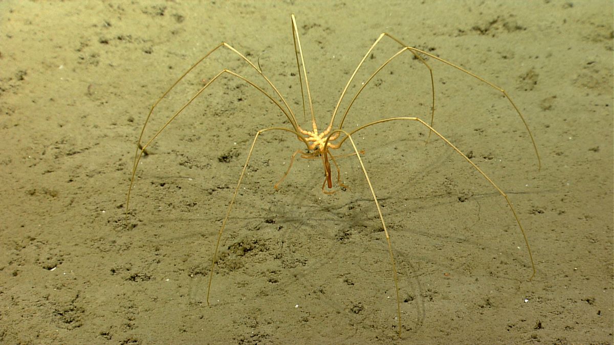
The giant sea spiders can have leg spans of up to 20 inches (51 centimeters).
There are roughly 1,500 known species of sea spider, with some measuring up to 20 inches in leg span.
(Image credit: Science History Images/Alamy)
Scientists have captured stunning video of a dinner-plate-size sea spider crawling on the seafloor off the South Sandwich Islands, a chain of volc
Sea spiders, also known as pycnogonids, are distant cousins of the creepy-crawly arachnids we see scuttling about on land. These creatures can have leg spans of up to 20 inches (51 centimeters) — nearly double those of the largest land spiders, whose leg spans top out at around 12 inches (30 cm).
According to the Schmidt Ocean Institute, which shared the footage, the spider's massive size is a result of deep-sea gigantism, the tendency for deep-sea creatures to grow significantly larger than their shallow-water relatives. In this case, the pycnogonid was filmed at a depth of 6,903 feet (2,104 meters).
"Immense pressure and frigid temperatures, while insurmountable obstacles to land-lovers like humans, allow some animals to have very slow metabolisms and the ability to reach gargantuan proportions," Schmidt Ocean Institute representatives wrote in a Facebook post.
Larger animals can also move faster and farther to find food or to locate a mate, which is important when both are scarce.
Deep-sea gigantism is particularly prevalent toward the poles, where freezing temperatures facilitate slower metabolisms. Schmidt Ocean Institute representatives described sea spiders as both "abundant" and "abundantly large" in polar regions.
There are roughly 1,500 species of sea spider known to science and likely many more yet to be discovered, according to the post. Sea spiders inhabit oceans around the world and range just a few millimeters to the size of a serving platter. The species of spider in the video from the Schmidt Ocean Institute has not been specified.
The largest members of this group are usually found at depths between 7,200 and 13,100 feet (2,200 to 4,000 m), according to the Monterey Bay Aquarium Research Institute.
Instead of spinning webs or creating burrows as land spiders do, sea spiders use a specialized tube-like mouth structure, called a proboscis, to slurp up prey such as sea anemones, jellies and other invertebrates.
This latest footage was taken by remotely operated vehicle pilots as part of the Schmidt Ocean Institute's South Sandwich Islands expedition, a mission to locate and describe new species in these frigid waters. According to the institute, scientists have discovered only 10% of ocean life.
RELATED VIDEO
Sea Spider 🌊 The Giant Spider Of The Sea!
Top 10 Most UNUSUAL Deep Sea Creatures Ever Discovered
Top 10 Most Bizarre Deep Sea Creatures Ever Discovered
Het is Tijd om te Stoppen met Verbaasd te Zijn over Verrassend Weer: Een Wetenschappelijke Analyse
Het is Tijd om te Stoppen met Verbaasd te Zijn over Verrassend Weer: Een Wetenschappelijke Analyse
De wereld heeft de afgelopen decennia een opmerkelijke toename in extreme weersomstandigheden ervaren, variërend van ongebruikelijke hittegolven en zware regenval tot intense stormen en droogtes. Dit fenomeen roept de vraag op waarom we nog steeds verrast zijn door deze 'verrassende' weersomstandigheden, vooral gezien de wetenschappelijke consensus rond klimaatverandering. Deze analyse onderzoekt de relatie tussen klimaatverandering en extreme weersomstandigheden, de rol van media en publieke perceptie, en de noodzaak van aanpassingen in de manier waarop we over weer en klimaat denken.
1. De Wetenschap van Klimaatverandering
Klimaatverandering verwijst naar langdurige veranderingen in temperatuur en weerspatronen op aarde. Wetenschappelijke studies, waaronder die van het Intergovernmental Panel on Climate Change (IPCC), tonen aan dat menselijke activiteiten, zoals de verbranding van fossiele brandstoffen en ontbossing, de belangrijkste drijfveren zijn van de opwarming van de aarde. Dit leidt tot veranderingen in de atmosfeer, oceanen en landoppervlakken, wat op zijn beurt extreme weersomstandigheden kan veroorzaken. De gevolgen van deze veranderingen zijn verstrekkend en beïnvloeden ecosystemen, menselijke gezondheid, voedselzekerheid en economieën wereldwijd.
1.1. Mechanismen van Extreme Weersomstandigheden
Extreme weersomstandigheden zijn het resultaat van complexe interacties tussen verschillende meteorologische factoren. Een voorbeeld hiervan is de toename van de gemiddelde temperatuur, die leidt tot meer verdamping van water en intensere regenval. Deze veranderingen kunnen resulteren in overstromingen en andere natuurrampen die gemeenschappen zwaar kunnen belasten. Evenzo kunnen veranderingen in de zeetemperatuur de frequentie en intensiteit van orkanen beïnvloeden. Warmer zeewater biedt meer energie voor stormen, wat leidt tot krachtigere en destructievere orkanen.
Daarnaast kunnen veranderingen in windpatronen en atmosferische druksystemen ook bijdragen aan extreme weersomstandigheden. De verschuiving van de jetstream, bijvoorbeeld, kan leiden tot langdurige periodes van droogte in sommige gebieden en overmatige neerslag in andere. Dit soort extremen is niet alleen een bedreiging voor de natuur, maar heeft ook directe gevolgen voor de landbouw, infrastructuur en menselijke gezondheid. Het is essentieel dat we deze mechanismen begrijpen om te erkennen dat wat we nu als 'verrassend' beschouwen, steeds vaker zal voorkomen.
1.2. De Rol van de Mens
De rol van de mens in klimaatverandering kan niet genoeg worden benadrukt. De verbranding van fossiele brandstoffen voor energie, vervoer en industrie is de grootste bron van broeikasgasemissies, met name kooldioxide (CO2) en methaan (CH4). De uitstoot van deze gassen leidt tot een versterking van het broeikaseffect, wat de aarde opwarmt. Ontbossing, een andere belangrijke factor, vermindert de hoeveelheid CO2 die door bomen en andere planten kan worden opgenomen. Hierdoor komt er meer CO2 in de atmosfeer, wat de opwarming verder versnelt.
Daarnaast zijn er ook andere menselijke activiteiten die bijdragen aan klimaatverandering. Landbouwpraktijken, zoals het gebruik van kunstmest en het houden van vee, stoten aanzienlijke hoeveelheden broeikasgassen uit. De productie van voedsel en de bijbehorende logistiek dragen ook bij aan de uitstoot van CO2 en andere schadelijke gassen. Het begrijpen van deze oorzaken is cruciaal voor het ontwikkelen van effectieve strategieën om de impact van klimaatverandering te verminderen.
1.3. Gevolgen van Klimaatverandering
De gevolgen van klimaatverandering zijn al zichtbaar en zullen naar verwachting in de toekomst verergeren. Eén van de meest zorgwekkende gevolgen is de stijging van de zeespiegel, veroorzaakt door het smelten van gletsjers en ijskappen, evenals de thermische uitzetting van water bij hogere temperaturen. Dit bedreigt laaggelegen kustgebieden en kan leiden tot grootschalige verplaatsingen van mensen en verlies van land.
Daarnaast heeft klimaatverandering invloed op de biodiversiteit. Veel soorten kunnen zich niet snel genoeg aanpassen aan de veranderende omstandigheden, wat leidt tot uitsterven en verstoring van ecosystemen. Dit heeft niet alleen gevolgen voor de natuur, maar ook voor de mensen die afhankelijk zijn van deze ecosystemen voor voedsel, water en andere hulpbronnen.
Extreme weersomstandigheden, zoals hittegolven, droogtes en zware stormen, brengen ook aanzienlijke risico's met zich mee voor de volksgezondheid. Hittegolven kunnen leiden tot een verhoogde sterfte onder kwetsbare bevolkingsgroepen, terwijl de verspreiding van ziekten door insecten zoals muggen kan toenemen door warmer weer en veranderende neerslagpatronen.
1.4. Aanpassing en Mitigatie
Om de gevolgen van klimaatverandering aan te pakken, zijn zowel aanpassing als mitigatie (Mitigatie is een term die vaak wordt gebruikt in de context van risico- en milieubeheer. Het verwijst naar het proces van het verminderen of verzachten van de ernst of impact van een probleem, risico of negatieve gevolgen. In het geval van klimaatverandering bijvoorbeeld, kan mitigatie inhouden dat er maatregelen worden genomen om de uitstoot van broeikasgassen te verminderen, zoals het bevorderen van hernieuwbare energiebronnen of het verbeteren van energie-efficiëntie. Het doel van mitigatie is om de schade die kan ontstaan door bepaalde risico's of negatieve effecten te beperken.) noodzakelijk. Aanpassing houdt in dat we ons aanpassen aan de onvermijdelijke gevolgen van klimaatverandering, zoals het verbeteren van de infrastructuur om overstromingen te weerstaan of het ontwikkelen van droogtebestendige gewassen. Dit vereist samenwerking tussen overheden, gemeenschappen en bedrijven om effectieve strategieën te implementeren die de kwetsbaarheid verminderen.
Mitigatie daarentegen richt zich op het verminderen van de uitstoot van broeikasgassen en het verminderen van de impact van menselijke activiteiten op het klimaat. Dit kan worden bereikt door de overstap naar hernieuwbare energiebronnen, zoals zonne- en windenergie, en door het bevorderen van energie-efficiëntie. Daarnaast is het belangrijk om duurzame landbouwpraktijken te implementeren en ontbossing tegen te gaan.
1.5. De Rol van Technologie en Innovatie
Technologie en innovatie spelen een cruciale rol in de strijd tegen klimaatverandering. Nieuwe technologieën kunnen helpen bij het verminderen van emissies en het verbeteren van de efficiëntie van energieverbruik. Bijvoorbeeld, elektrische voertuigen en slimme energienetwerken kunnen bijdragen aan een duurzamer transportsysteem en energiebeheer.
Bovendien kunnen innovaties in carbon capture en opslag (CCS) bijdragen aan het verminderen van de hoeveelheid CO2 in de atmosfeer. Door CO2 af te vangen bij de bron en het veilig op te slaan, kunnen we de impact van fossiele brandstoffen verder verminderen. De ontwikkeling van alternatieve eiwitbronnen, zoals plantaardige en kweekvlees, kan ook helpen om de ecologische voetafdruk van de voedselproductie te verkleinen.
1.6. De Kracht van Samenwerking
Klimaatverandering is een wereldwijd probleem dat samenwerking op alle niveaus vereist. Internationale verdragen, zoals het Klimaatakkoord van Parijs, zijn essentieel om landen te verenigen in de strijd tegen klimaatverandering. Dit akkoord stelt doelstellingen vast voor de vermindering van broeikasgasemissies en stimuleert landen om hun inspanningen te intensiveren.
Daarnaast is het belangrijk dat lokale gemeenschappen en bedrijven ook betrokken worden bij de mitigatie- en aanpassingsstrategieën. Educatie en bewustwording zijn cruciaal om individuen aan te moedigen duurzame keuzes te maken en bij te dragen aan de oplossing. Het creëren van een cultuur van duurzaamheid en verantwoordelijkheidsbesef helpt niet alleen bij het aanpakken van klimaatverandering, maar versterkt ook de sociale cohesie en veerkracht van gemeenschappen.
1.7. Conclusie
Klimaatverandering is een complex en urgent probleem dat diepgaande gevolgen heeft voor onze planeet en de mensen die erop leven. Het begrijpen van de mechanismen achter klimaatverandering en extreme weersomstandigheden is essentieel voor het ontwikkelen van effectieve strategieën om deze uitdagingen aan te gaan. Door middel van samenwerking, technologie en innovatieve benaderingen kunnen we werken aan een duurzame toekomst. Het is van vitaal belang dat we nu handelen om de gevolgen voor toekomstige generaties te beperken en ervoor te zorgen dat onze aarde een leefbare plek blijft voor iedereen.
Trajecten van tropische cyclonen in de Noord-Atlantische Oceaan van 1851 tot 2019
(Bron: Niilfanion)
2. Publieke Perceptie en Media
De manier waarop het publiek reageert op extreme weersomstandigheden is vaak beïnvloed door mediarepresentaties en culturele percepties. Wanneer een ongewoon weerfenomeen zich voordoet, kan de media het sensationeel presenteren, wat leidt tot een tijdelijke golf van verontwaardiging en verbazing. Deze sensationele berichtgeving heeft de potentie om de publieke perceptie te vervormen en een gevoel van schok te creëren dat niet in overeenstemming is met de wetenschappelijke realiteit. Bij extreme weersomstandigheden zoals orkanen, overstromingen of hittegolven zien we vaak dat de media de dramatiek van de situatie benadrukken. Dit kan leiden tot angst en bezorgdheid, maar ook tot een kortstondige interesse in het onderwerp.
In de huidige digitale tijdperk wordt deze dynamiek verder versterkt door sociale media. Berichten verspreiden zich in een razendsnel tempo en mensen delen hun ervaringen en reacties, vaak zonder dat ze de tijd nemen om de feiten te verifiëren. Dit kan resulteren in een sneeuwbaleffect van verkeerde informatie en sensatiezucht. Het gevolg is dat de publieke perceptie van extreme weersomstandigheden vaak gebaseerd is op emotie en niet op feitelijke kennis.
2.1. De Rol van de Media
Media spelen een cruciale rol in het vormgeven van de publieke perceptie van weer en klimaat. Sensationele berichtgeving over extreme weersomstandigheden kan bijdragen aan een kortstondige opwinding, maar leidt vaak niet tot diepgaand begrip van de onderliggende wetenschappelijke principes. Dit creëert een kloof tussen wetenschappelijke kennis en publieke bewustwording. Wanneer de media zich richten op de meest schokkende of verontrustende aspecten van een weerfenomeen, kan dit ertoe leiden dat de complexiteit van klimaatverandering en de verschillende factoren die bijdragen aan extreme weersomstandigheden worden genegeerd.
Bijvoorbeeld, in de berichtgeving over een zware storm wordt vaak de focus gelegd op de schade en de onmiddellijke gevolgen voor de bevolking. De oorzaak van de storm, zoals klimaatverandering, wordt zelden in detail besproken. Dit kan een vertekend beeld creëren van de relatie tussen menselijk handelen en de natuur. Het publiek krijgt daardoor een onvolledig beeld van de situatie, wat het moeilijk maakt om weloverwogen beslissingen te nemen over bijvoorbeeld noodmaatregelen of duurzaam gedrag.
Bovendien kunnen media-instanties soms terugvallen op clichématige beelden en verhalen die niet de diversiteit en nuance van de werkelijkheid weergeven. Het gebruik van stereotype beelden kan ook bijdragen aan een simplistisch begrip van de gevolgen van extreme weersomstandigheden. Zo worden mensen in kwetsbare gemeenschappen vaak afgebeeld als passieve slachtoffers, terwijl zij in werkelijkheid actief betrokken zijn bij hun eigen hulp en herstel. Dit kan de publieke perceptie verder vervormen en leiden tot een gebrek aan empathie en begrip voor de complexiteit van de situatie.
2.2. De Impact van Sociale Media
Sociale media hebben de dynamiek van de berichtgeving over extreme weersomstandigheden veranderd. Platforms zoals Twitter, Facebook en Instagram stellen gebruikers in staat om informatie in real-time te delen, wat kan leiden tot een snellere verspreiding van nieuws. Hoewel dit positieve aspecten heeft, zoals het vergroten van het bereik van belangrijke informatie, kan het ook de verspreiding van desinformatie bevorderen. De snelheid waarmee berichten worden gedeeld, maakt het moeilijk om feiten van fictie te onderscheiden.
Bovendien kunnen virale berichten en memes de publieke perceptie verder beïnvloeden. Wanneer een bericht of afbeelding viraal gaat, kan dit de aandacht van het publiek afleiden van de feitelijke situatie en in plaats daarvan leiden tot een focus op sensationele of komische elementen. Dit kan de ernst van de situatie bagatelliseren en het publiek een vertekend beeld geven van de realiteit. Het gebruik van humor of sarcasme kan in sommige gevallen een copingmechanisme zijn, maar het kan ook bijdragen aan een gebrek aan urgentie in de manier waarop mensen extreme weersomstandigheden en de gevolgen daarvan benaderen.
2.3. Oplossingen voor een Betere Informatievoorziening
Om de kloof tussen wetenschappelijke kennis en publieke perceptie te verkleinen, is het essentieel dat media verantwoordelijk omgaan met hun berichtgeving over extreme weersomstandigheden en klimaatverandering. Dit kan onder andere door het aanbieden van diepgaandere analyses en het betrekken van experts bij de berichtgeving. Media kunnen ook educatieve campagnes opzetten om de complexiteit van klimaatverandering beter uit te leggen en het publiek te informeren over de oorzaken en gevolgen van extreme weersomstandigheden.
Daarnaast is het belangrijk dat het publiek zelf kritisch leert omgaan met informatie, vooral op sociale media. Onderwijs over mediawijsheid en het belang van feitelijke verificatie kan bijdragen aan een beter begrip van de werkelijkheid. Door het publiek te stimuleren om verder te kijken dan sensationele koppen en om bronnen te controleren, kan de algehele perceptie van extreme weersomstandigheden en klimaatverandering verbeteren. Op deze manier kan de rol van de media in het informeren van het publiek niet alleen bijdragen aan een beter begrip, maar ook aan een actievere betrokkenheid bij het aanpakken van klimaatgerelateerde uitdagingen.
Can we stop being surprised by extreme weather? #climateresearch
3. De Psychologie van Verrassing
Mensen zijn van nature geneigd om te reageren op verrassingen met verbazing en ontkenning. Dit psychologische mechanisme kan worden verklaard door cognitieve biases zoals het 'normalcy bias', waarbij individuen de waarschijnlijkheid van ongebruikelijke gebeurtenissen onderschatten. Het idee dat 'dit niet kan gebeuren in mijn leven' leidt tot een gebrek aan voorbereiding en een onvermogen om de ernst van de situatie te erkennen. Wanneer mensen geconfronteerd worden met onverwachte gebeurtenissen, zoals natuurrampen, pandemieën of economische crises, kunnen ze vaak niet direct de impact van deze gebeurtenissen begrijpen. Dit leidt tot een vertraging in de reactie en kan de gevolgen verergeren.
De normalcy bias kan ook voortkomen uit een diepgeworteld verlangen naar stabiliteit en voorspelbaarheid. Mensen zijn sociale wezens die gebaat zijn bij routine en structuur. Wanneer deze structuren plotseling worden verstoord, kan dit leiden tot een gevoel van onbehagen en desoriëntatie. De neiging om terug te vallen op vertrouwde denkpatronen kan voorkomen dat individuen zich aanpassen aan nieuwe realiteiten. Dit is bijzonder problematisch in tijden van crisis, waar snel handelen en flexibiliteit essentieel zijn voor overleving en herstel.
3.1. Het Gevoel van Controle
Mensen willen vaak een gevoel van controle over hun omgeving, en het idee van een 'normaal' klimaat biedt deze illusie. Wanneer dat 'normale' klimaat wordt verstoord door extreme weersomstandigheden, zoals hittegolven, overstromingen of orkanen, kan dit leiden tot angst en verwarring. De ervaring van het verliezen van controle over de eigen omgeving kan traumatisch zijn en heeft vaak diepgaande psychologische gevolgen. Het is cruciaal dat individuen de nieuwe realiteit van een veranderend klimaat erkennen om zich aan te passen en veerkracht te ontwikkelen.
Er is een sterke correlatie tussen de perceptie van controle en psychologisch welzijn. Wanneer mensen het gevoel hebben dat ze invloed hebben op hun situatie, zijn ze geneigd om proactiever te reageren op bedreigingen. Dit kan zich uiten in het nemen van preventieve maatregelen, zoals het aanleggen van noodvoorraden of het volgen van weerberichten. Aan de andere kant, wanneer mensen zich machteloos voelen, kan dit leiden tot angst, depressie en zelfs apathie. Dit gebrek aan controle kan hen weerhouden van het ondernemen van noodzakelijke stappen om zichzelf en hun gemeenschappen te beschermen.
3.2. De Rol van Sociale Media
In de moderne wereld speelt sociale media een cruciale rol in hoe mensen informatie ontvangen en verwerken, vooral in tijden van crisis. De snelheid waarmee informatie zich verspreidt kan zowel een zegen als een vloek zijn. Aan de ene kant kunnen mensen snel op de hoogte worden gebracht van gevaarlijke situaties, terwijl ze aan de andere kant ook worden blootgesteld aan een overvloed aan desinformatie. Deze desinformatie kan de reeds bestaande cognitieve biases versterken, waardoor het nog moeilijker wordt om de ernst van een situatie te erkennen.
Bovendien kunnen sociale media ook leiden tot een gevoel van groepsdruk. Wanneer mensen zien dat anderen niet reageren op een crisis of de situatie bagatelliseren, kan dit hun eigen perceptie beïnvloeden. Dit kan hen ontmoedigen om hun zorgen serieus te nemen of om actie te ondernemen. Het effect van sociale bevestiging kan de neiging om te ontkennen of te minimaliseren versterken, wat weer bijdraagt aan de normalcy bias.
3.3. Omgaan met Verrassing en Onzekerheid
Het is van groot belang dat individuen strategieën ontwikkelen om beter om te gaan met verrassingen en de daarmee gepaard gaande onzekerheden. Educatie en bewustwording zijn essentieel. Door mensen voor te lichten over de mogelijke gevolgen van klimaatverandering en andere crises, kunnen we hen aanmoedigen om voorzichtiger en proactiever te zijn. Training in crisismanagement kan ook een waardevolle aanvulling zijn, zodat mensen beter voorbereid zijn op onvoorziene gebeurtenissen.
Daarnaast is het bevorderen van een community-geest cruciaal. Samenwerken met anderen kan helpen om een gevoel van controle terug te winnen en de angst te verlichten. Dit kan door lokale initiatieven, zoals buurtpreventieteams of gezamenlijke noodplannen, te ondersteunen. Wanneer mensen zich verenigd voelen in hun inspanningen om zich voor te bereiden op en te reageren op crises, kan dit hun veerkracht aanzienlijk vergroten.
Conclusie
De psychologie van verrassing en de bijbehorende reacties zijn complex en diepgeworteld in onze menselijkheid. Het begrijpen van deze mechanismen is essentieel voor het ontwikkelen van effectieve strategieën om ons voor te bereiden op de uitdagingen van de toekomst. Door de normalcy bias te erkennen en ons bewust te zijn van de rol van sociale media, kunnen we beter voorbereid zijn op de verrassingen die het leven ons kan bieden.
Het is cruciaal dat we onze benadering van weer en klimaat veranderen. In plaats van verrast te zijn door extreme weersomstandigheden, moeten we ons voorbereiden op hun frequentie en intensiteit. Dit omvat veranderingen in infrastructuur, beleidsvorming en educatie. De huidige trends wijzen op een toenemende ernst van klimaatverandering, wat ons dwingt om onze strategieën te herzien en aan te passen aan de nieuwe realiteit. Dit is niet alleen een kwestie van overleven, maar ook van het creëren van veerkrachtige gemeenschappen die in staat zijn om de uitdagingen van de toekomst aan te gaan.
4.1. Beleidsaanbevelingen
Overheden en beleidsmakers moeten proactief beleid ontwikkelen dat gericht is op het verminderen van de impact van extreme weersomstandigheden. Dit kan onder meer het verbeteren van de infrastructuur, het versterken van rampenplannen en het investeren in duurzame energiebronnen omvatten. Een belangrijk aspect van dit beleid is het integreren van klimaatrisico's in alle facetten van de beleidsvorming, van stadsplanning tot landbouwbeleid. Dit betekent dat er ook een nauwe samenwerking moet zijn tussen verschillende sectoren, zoals milieu, economie en sociale zaken.
Daarnaast is het van wezenlijk belang dat er financiële middelen beschikbaar komen voor de uitvoering van deze beleidsmaatregelen. Dit kan door middel van subsidies voor innovatieve technologieën, belastingvoordelen voor duurzame initiatieven en investeringen in groene infrastructuur. Het is ook essentieel om publieke en private partnerschappen te stimuleren, zodat de verantwoordelijkheden voor aanpassing en voorbereiding breed worden gedeeld.
4.2. Infrastructuurverbeteringen
De infrastructuur van een land moet bestand zijn tegen de gevolgen van extreme weersomstandigheden. Dit houdt in dat bestaande structuren zoals wegen, bruggen en gebouwen moeten worden versterkt of aangepast aan de nieuwe klimaatrealiteit. Bijvoorbeeld, het aanleggen van waterdoorlatende bestrating kan helpen om overstromingen te verminderen en de afvoer van regenwater te verbeteren. Ook kunnen dijken en andere waterkeringen worden verhoogd en versterkt om beter bestand te zijn tegen stijgende zeespiegels en extreem weer.
Bovendien moet er aandacht zijn voor het herstel van natuurlijke ecosystemen, zoals wetlands en bossen, die als natuurlijke buffer fungeren tegen overstromingen en erosie. Het beschermen en herstellen van deze gebieden kan niet alleen helpen bij het verminderen van de impact van extreme weersomstandigheden, maar ook bijdragen aan de biodiversiteit en het welzijn van lokale gemeenschappen.
4.3. Opvoeding en Bewustwording
Naast infrastructuur en beleid is ook educatie een cruciaal element in onze voorbereiding op extreme weersomstandigheden. Het publiek moet zich bewust zijn van de risico's die klimaatverandering met zich meebrengt en hoe zij zich daarop kunnen voorbereiden. Dit kan door middel van voorlichtingscampagnes, workshops en trainingen die gericht zijn op het verhogen van de weerbaarheid van individuen en gemeenschappen.
Scholen en onderwijsinstellingen spelen hierin een belangrijke rol. Door klimaateducatie te integreren in het curriculum kunnen jongeren worden voorbereid op een toekomst waarin klimaatverandering een centrale rol speelt. Het aanleren van praktische vaardigheden, zoals noodplannen opstellen en duurzaam leven, kan hen helpen om actief bij te dragen aan een veerkrachtigere samenleving.
4.4. Samenwerking en Vernieuwing
Tot slot is samenwerking op zowel lokaal als internationaal niveau van groot belang. Klimaatverandering kent geen grenzen en de aanpak ervan vereist collectieve inspanningen. Het delen van kennis, technologie en middelen tussen landen kan leiden tot innovatieve oplossingen en effectievere aanpassingsstrategieën. De rol van internationale organisaties en samenwerkingsverbanden kan hierdoor niet worden onderschat.
Door een integrale aanpak te hanteren die beleidsvorming, infrastructuurverbeteringen en educatie combineert, kunnen we niet alleen de impact van extreme weersomstandigheden beperken, maar ook een fundament leggen voor een duurzame en veerkrachtige toekomst. Het is tijd om actie te ondernemen en ons voor te bereiden op de uitdagingen die ons te wachten staan.
5. BESLUIT
Het is tijd om te stoppen met verbaasd te zijn over verrassend weer. De wetenschap van klimaatverandering biedt ons de tools en kennis om de realiteit van extreme weersomstandigheden te begrijpen en ons daarop voor te bereiden. Dit is niet alleen een kwestie van wetenschappelijk onderzoek, maar ook van maatschappelijke verantwoordelijkheid. De steeds frequentere en intensere weersomstandigheden, zoals hittegolven, overstromingen, en orkanen, zijn niet langer een ver van ons bed-show. Ze zijn een tastbare realiteit die ons dagelijks leven beïnvloedt. Het is cruciaal dat we deze veranderingen niet alleen herkennen, maar ook actief aanpakken.
Door de kloof tussen wetenschappelijke kennis en publieke perceptie te overbruggen, kunnen we een samenleving creëren die beter is uitgerust om te gaan met de uitdagingen van een veranderend klimaat. Dit vraagt om een gezamenlijke inspanning van wetenschappers, beleidsmakers, en de gemeenschap als geheel. We moeten de wetenschap van klimaatverandering toegankelijk maken voor iedereen, ongeacht hun achtergrond of opleidingsniveau. Dit kan door het organiseren van voorlichtingscampagnes, het ontwikkelen van educatieve programma's en het stimuleren van maatschappelijke betrokkenheid.
Daarnaast is het van groot belang dat we begrijpen dat klimaatverandering niet alleen een kwestie is van milieu, maar ook van sociale rechtvaardigheid. De meest kwetsbare groepen in onze samenleving, zoals mensen met lage inkomens en minderheden, worden vaak het hardst getroffen door de gevolgen van extreme weersomstandigheden. Daarom moeten we bij onze aanpak van klimaatverandering ook aandacht besteden aan de sociale en economische ongelijkheden die het probleem verergeren. Een inclusieve benadering is noodzakelijk om ervoor te zorgen dat iedereen kan profiteren van de oplossingen die we ontwikkelen.
6. Aanbevelingen voor Verdere Studie
Toekomstig onderzoek moet zich richten op de communicatie van klimaatwetenschap, de rol van onderwijs in klimaatbewustzijn en de ontwikkeling van strategieën voor effectieve aanpassing aan extreme weersomstandigheden. Dit zal ons in staat stellen om de impact van klimaatverandering beter te begrijpen en te mitigeren.
In de eerste plaats moeten we ons concentreren op de manier waarop we klimaatwetenschap communiceren. Dit houdt in dat we jargon en complexe terminologie vermijden die het voor het grote publiek moeilijk maakt om de boodschap te begrijpen. Wetenschappers en communicatiespecialisten moeten samenwerken om duidelijke, beknopte en overtuigende boodschappen te formuleren die mensen aanspreken. Het gebruik van visuele hulpmiddelen, zoals infographics en video's, kan ook helpen om ingewikkelde concepten toegankelijker te maken.
Daarnaast is het cruciaal dat we de rol van onderwijs in klimaatbewustzijn verder onderzoeken. Scholen en universiteiten spelen een sleutelrol in het vormen van de opvattingen van de volgende generatie. Curriculumontwikkeling moet gericht zijn op het integreren van klimaatverandering in verschillende vakken, zodat studenten niet alleen de wetenschap erachter begrijpen, maar ook de sociale en economische impact ervan. Praktische ervaringen, zoals projecten in de lokale gemeenschap, kunnen studenten helpen om klimaatverandering als een urgent probleem te zien dat directe actie vereist.
Een andere belangrijke aanbeveling is het ontwikkelen van strategieën voor effectieve aanpassing aan extreme weersomstandigheden. Dit betekent dat we niet alleen moeten focussen op mitigatie ( afzwakking, beperking ), maar ook op hoe we ons kunnen aanpassen aan de gevolgen van klimaatverandering die al zichtbaar zijn. Dit kan inhouden dat we infrastructuur ontwerpen die beter bestand is tegen extreme weersomstandigheden, zoals waterdichte gebouwen en verbeterde afwateringssystemen. Ook moeten er strategieën worden ontwikkeld voor de bescherming van ecosystemen die ons kunnen helpen bij het bestrijden van de gevolgen van klimaatverandering, zoals natuurgebieden die overstromingen kunnen absorberen.
Verder is het van belang om te kijken naar de rol van technologie in de strijd tegen klimaatverandering. Innovaties zoals hernieuwbare energie, energie-efficiënte technologieën en slimme steden kunnen bijdragen aan zowel mitigatie als aanpassing. Onderzoek naar deze technologieën moet worden gestimuleerd en gefinancierd om ervoor te zorgen dat we gebruik kunnen maken van de beste beschikbare middelen in onze strijd tegen klimaatverandering.
Tot slot moeten we ook kijken naar de internationale samenwerking. Klimaatverandering is een globaal probleem dat niet binnen de grenzen van landen of regio's kan worden opgelost. Effectieve samenwerking tussen landen is cruciaal om de gevolgen van klimaatverandering aan te pakken. Dit omvat het delen van kennis, technologie en middelen, evenals het ontwikkelen van gezamenlijke strategieën voor mitigatie en aanpassing.
De uitdagingen die klimaatverandering met zich meebrengt, zijn groot, maar ze zijn niet onoverkomelijk. Door de wetenschap van klimaatverandering te omarmen en de kloof tussen kennis en publieke perceptie te overbruggen, kunnen we een veerkrachtige samenleving opbouwen. Met de juiste educatie, communicatie en samenwerking kunnen we de weg inslaan naar een duurzame toekomst. Het is aan ons, nu, om actie te ondernemen en de nodige stappen te zetten voor een beter klimaat, zowel voor onszelf als voor de generaties die na ons komen.
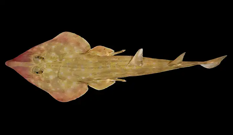
Over 800 new species discovered in world's biggest ocean mission
A new species of guitar shark, Rhinobatos sp., was identified at depths around 200 metres off the coasts of Mozambique and Tanzania by world-renowned shark expert David Ebert, also known as the ‘Lost Shark Guy’ (Ocean Census Species Discovery Awardee). This is only the 38th known guitar shark species worldwide, a group so at-risk that two-thirds of its species are threatened.
Over 800 new species discovered in world's biggest ocean mission
The Nippon Foundation Nekton Ocean Census has detailed the discovery of 866 new marine species, including a guitar shark, a deep-sea mollusc, and the first octocoral found in the Maldives, as part of its wider mission to transform the approach to ocean science.
This squat lobster, Galathea sp., is the first of its genus recorded in the southeastern Pacific Ocean, near Easter Island (Rapa Nui).
A new species of guitar shark, a deep-sea mollusc with potential in cancer treatment development, and the first octocoral to be discovered in the Maldives; these are just three of the more than 800 marine species newly discovered by scientists working across the world’s largest mission to unlock the mysteries of life in the ocean.
Marking a “significant step” in advancing our understanding of ocean biodiversity, the 866 new species to be detailed in total this week is just a fraction of the some 100,000 species that the mission – working under the The Nippon Foundation-Nekton Ocean Census umbrella – aims to uncover in the coming years.
The overarching goal of this mission is to not only elucidate the mysteries of the ocean but to transform marine science and its approach to new species identification, by accelerating the process and closing the critical gaps in knowledge of life underwater before it’s too late.
The mission was born of the belief that one of the biggest hurdles marine biology faces in engaging both the public and private sectors is the long and drawn-out process for identifying new species, taking up to – in some cases – 14 years for formal identification to be made complete.
By this point, the Nippon Foundation and Nekton have argued, many of the species actually go extinct before they are even documented. It’s this that formed the basis of the mission – an international collaborative effort comprising some 800 scientists from over 400 institutions around the world launched in April 2023 with the aim of transforming and accelerating these current approaches.
“The ocean covers 71% of our planet, yet it is said that only 10% of marine life has been discovered so far, leaving an estimated 1 to 2 million species still undocumented,” said Mitsuyuki Unno, executive director of the Nippon Foundation. “These latest findings demonstrate how international collaboration can advance our understanding of ocean biodiversity.”
The Ocean Census global alliance has conducted – to date – ten global expeditions and hosted eight Species Discovery Workshops, awarding 19 Species Discovery Awards to taxonomists worldwide.
Among the findings, a new species of shark, sea butterfly, mud dragon, bamboo coral, water bear, octocoral, sponge, shrimp, crab, reef fish, squat lobster, pipehorse, limpet, hooded shrimp, sea spiders, and brittle stars encompassing dozens of taxonomic groups have now all been registered to the Ocean Census Biodiversity Data Platform.
The beta platform, developed in partnership with the UN Environment Programme World Conservation Monitoring Centre is now accessible to researchers and the public alike.
Mollusc_Granulina nekton - The Nippon Foundation-Nekton Ocean Census _ Jesus Ortega, Leopoldo Moro
Found at 3,053 m (10,016 ft) in the Jøtul Vent Field, this deep-sea limpet thrives in extreme environments.
Image courtesy of The Nippon Foundation-Nekton Ocean Census/Martin Hartley.
A new species of Pygmy pipehorse found in Sodwana Bay, South Africa.
Image courtesy of The Nippon Foundation-Nekton Ocean Census/Richard Smith.
Using divers, submersibles, and remotely operated vehicles all these new species were identified from depths of one to 4,990 metres. Among the most notable discoveries were:
A new species of guitar shark – only the 38th known species of guitar shark worldwide found at around 200m depths off Mozambique and Tanzania by the world-renowned shark expert, David Ebert;
A Turridrupa magnifica – a marine gastropod at 200 to 500m depths off New Caledonia and Vanatau by Dr Peter Stahlschmidt, and a species that produces peptides with potential applications in pain relief and cancer treatment;
And a new octocoral – found in the Maldives by Aishath Sarah Hashim & Aminath Nasath Shanaan from the Maldives Marine Research Institute; one of only five known species of this genus and the first recorded in the Maldives.
The mission has gone many lengths to highlight the current problems surrounding the identification and classification process when it comes to new species, primarily that it can take years between being first encountered by scientists, being formally described and being published in a scientific journal.
Sponge_Janulum sp.- The Nippon Foundation-Nekton Ocean Census _ Michelle Kelly
“Too many species remain in limbo for years because the process of formally describing them is too slow,” said Professor Lucy Woodall, head of science at Ocean Census. “We urgently need to change that and adding the Species Discovery step gives us a way to rapidly start the process.
“Every new species – whether a shark or a sponge – deepens our understanding of marine ecosystems and the benefits they provide for the planet.”
Since the launch of the mission in 2023, Ocean Census has managed to pioneer new methods, forge new partnerships, and establish a new global network of participating scientists. Endorsed under the United Nations Ocean Decade, the Ocean Census has formed such partnerships with national marine research institutes, museums, universities, philanthropic organisations, and technology partners.
Oliver Steeds, director of the Ocean Census, said: “Our estimates suggest that discovering 100,000 new species could require at least $1bn. We are laying the groundwork to make large-scale species discovery a reality, but our impact will ultimately be determined by how this knowledge is used to support marine protection, climate adaptation, and biodiversity conservation.”
For the year ahead, the Ocean Census now plans to provide dozens more Species Discovery Awards, undertake ten new expeditions, and host seven additional Species Discovery Workshops across the Pacific, Indian, and Southern Oceans.
All further data will be added to the Ocean Census Biodiversity Data Platform.
RELATED VIDEOS
More than 100 new marine species discovered
A glimpse at some of the 100 new deep sea species discovered off the coast of Chile
Scientists discover 100 new maritime species off New Zealand | DW News
Marine researchers have uncovered what could be the most expansive cloned organism ever documented—an enormous seaweed specimen stretching over 300 miles along Sweden’s Baltic coast. This massive clone, identified as a “super female” of Fucus vesiculosus, better known as bladderwrack, has reshaped what scientists understand about marine ecosystems and genetic survival.
A Hidden Giant Beneath the Waves
At first, DNA analysis led researchers to believe they had identified a different species of seaweed, but closer examination confirmed that this vast organism is, in fact, bladderwrack. This discovery is remarkable because bladderwrack is a foundational species in the Baltic, forming underwater forests that serve as critical habitats for snails, crustaceans, and other marine life.
Unlike its counterparts in saltier oceans, this particular Fucus vesiculosus has adapted to the Baltic’s lower salinity levels, allowing it to spread extensively. While bladderwrack typically reproduces sexually, the conditions of the Baltic Sea have favored an unusual survival strategy—cloning. This means that rather than mixing genetic material, the organism has been duplicating itself, producing an immense network of genetically identical individuals.
The clone of bladderwrack in the Baltic Sea was long assumed to be a separate species, which was called narrow seaweed.
The Role of Climate in Bladderwrack’s Future
With climate change affecting ocean temperatures and salinity, the future of this record-breaking seaweed is uncertain. “The Baltic Sea is entering a period of warmer and possibly even fresher seawater,” explained marine biologist Kerstin Johannesson, co-lead author of the study published in Molecular Ecology. “Every species must adapt to these changes, including the dominant bladderwrack.”
Although its cloning ability has allowed it to thrive, this very mechanism might also be its greatest vulnerability. Without genetic diversity, the massive clone may struggle to withstand environmental shifts, leaving it at risk of disease or habitat changes.
Despite these challenges, the bladderwrack “super female” remains a crucial part of the Baltic ecosystem. “This clone comprises millions of individuals,” said study co-author Ricardo Pereyra. “In some areas, it is completely dominant, while in others, it coexists with sexually reproduced bladderwrack.”
While other large clones have been identified in the Baltic, none compare to the scale of this one. Its longevity and dominance highlight the complexity of marine ecosystems and raise new questions about how cloned organisms might survive in a rapidly changing world.
For now, the world’s largest clone continues to shape the Baltic’s underwater landscape, providing shelter and stability for marine life. Whether it can endure future environmental shifts remains to be seen.
Russian fisherman reels in bizarre ‘Alien-Like’ fish
Russian fisherman reels in bizarre ‘Alien-Like’ fish
In the depths of the ocean, where countless strange fish and creatures dwell in perpetual darkness, they remain unseen, unless unexpectedly caught. This was the case during an expedition by a Russian deep-sea fisherman, who was stunned when he reeled in a bizarre creature that strikingly resembled an alien’s head.
The eerie catch was made by Roman Fedortsov during an expedition in the northern Pacific Ocean.
The fisherman shared the video of the strange creature with his followers, with viewers comparing the bulbous fish to an extraterrestrial or even Krang, the villain from Teenage Mutant Ninja Turtles.
Fisherman Fedortsov has previously made headlines thanks to other weird and wonderful catches which you can view at Dailymail.
Despite its eerie appearance, the fish was not an alien or a mutant but rather a species known as the smooth lumpsucker, a deep-sea fish recognized for its distinctive, gelatinous look.
Fisherman horrified after catching baffling ‘alien’ animal from the ocean depths
Fisherman horrified after catching baffling ‘alien’ animal from the ocean depths
What would really happen if the Gulf Stream collapsed? Scientists warn major global current is WEAKENING - raising concerns of a real-life Day After Tomorrow
What would really happen if the Gulf Stream collapsed? Scientists warn major global current is WEAKENING - raising concerns of a real-life Day After Tomorrow
As anyone who has seen 'The Day After Tomorrow' can attest, the world would look dramatically different if the Gulf Stream gave way.
In the 2004 blockbuster film starring Jake Gyllenhaal, an enormous 'superstorm' triggered by the collapse of the Gulf Stream sets off catastrophic natural disasters.
Around the world, people are frozen under layers of snow, drowned in massive tsunamis and dramatically crushed under vehicles thrown by tornados.
Now, scientists at the Met Office warn that Earth's system of ocean currents is 'weakening', although it is unlikely to collapse this century.
The Gulf Stream is only a small part of a much wider system of currents, officially called the Atlantic Meridional Overturning Circulation or AMOC.
Described as 'the conveyor belt of the ocean', it transports warm water near the ocean's surface northwards from the tropics up to the northern hemisphere, keeping Europe, the UK and the US east coast temperate.
Lead author Dr Jonathan Baker, a senior scientist at the Met Office, said: 'The AMOC has a crucial role in regulating our climate; without it, northwest Europe’s temperatures would be much cooler.
'Although our study shows that collapse over the next 75 years is unlikely, the AMOC is very likely to weaken, which will present climate challenges for Europe and beyond.'
In the 2004 blockbuster film starring Jake Gyllenhaal , an enormous 'superstorm' triggered by the collapse of the Gulf Stream sets off catastrophic natural disasters
Characters are frozen under layers of snow, drowned in massive tsunamis and dramatically crushed under vehicles thrown by tornados
'If the AMOC were to collapse, it could also lead to significant cooling in northwest Europe and chaotic weather patterns worldwide, affecting crops yields and ecosystems,' Dr Baker said.
The academic stress that his study found the AMOC is unlikely to collapse this century, but a weakened AMOC poses 'serious climate challenges'.
'A weaker AMOC could alter global rainfall patterns, disrupt marine ecosystems, reduce the ocean's ability to store carbon, and accelerate sea level rise along the US east coast,' he said.
Professor David Thornalley, a climate scientist at University College London who was not involved with the study, said temperatures would plummet if the AMOC collapsed.
'An AMOC collapse could cause more weather extremes, so as well as overall colder-than-average conditions, we also expect that there would be more winter storms caused by stronger westerly winds,' he told MailOnline.
'Unfortunately people would die due to stronger winter storms and flooding, and many old and young would be vulnerable to the very cold winter temperatures.'
However, in the UK, the effects would be 'minor' compared with elsewhere around the world, Professor Thornalley added.
'A collapse in AMOC would cause a shift in the tropical rainfall belt which would massively disrupt agriculture and water supplies across huge swathes of the globe,' he said.
The Gulf Stream is only a small part of a much wider system of currents, officially called the Atlantic Meridional Overturning Circulation (AMOC). This map indicates surface currents (solid curves) and deep currents (dashed curves) that form a portion of the AMOC. Colours of curves indicate approximate temperatures
In the Hollywood blockbuster The Day After Tomorrow (pictured), ocean currents around the world stop as a result of global warming, triggering a new ice age on Earth
What is the AMOC?
The Gulf Stream is a small part of a much wider system of currents, officially called the Atlantic Meridional Overturning Circulation or AMOC.
Described as 'the conveyor belt of the ocean', it transports warm water near the ocean's surface northwards - from the tropics to the northern hemisphere.
When the warm water reaches the North Atlantic (Europe and the UK, and the US east coast), it releases the heat and then freezes. As this ice forms, salt is left behind in the ocean water.
Due to the large amount of salt in the water, it becomes denser, sinks, and is carried southwards – back towards the tropics – in the depths below.
Eventually, the water gets pulled back up towards the surface and warms up in a process called upwelling, completing the cycle.
Scientists think AMOC brings enough warmth to the northern hemisphere that without it, large parts of Europe could enter a deep freeze.
'Many millions would be affected and suffer from drought, famine and flooding, in countries that are already struggling to deal with these issues. There would be huge numbers of climate refugees, geopolitical tensions would rise.'
Jonathan Bamber, a professor of Earth observation at the University of Bristol, agreed that if the AMOC were to collapse, the climate of northwest Europe would be 'unrecognisable compared to what it is today'.
'It would be several degrees cooler so that winters would be more typical of Arctic Canada and precipitation would decrease also,' he told MailOnline. 'Very harsh, cold winters would certainly be a threat to life.'
In 'The Day After Tomorrow', a collapse of the AMOC takes place over a matter of days and the fictional weather immediately switches to extreme cold.
Thankfully, such a rapid transition will not happen in real life, said Penny Holliday, head of marine physics and ocean circulation at the National Oceanography Centre in Southampton.
'If the AMOC does reach a tipping point it will happen over several decades at least,' she told MailOnline.
'However a slowdown of the AMOC, whether it is fast-acting or takes place over many decades, will lead to the generation of more extreme and violent weather systems that have the potential to cause deaths and major damage.'
Already, researchers have suggested that AMOC will weaken or collapse at some point in the 21st century as greenhouse gas emissions increase.
This illustration from the new Nature study depicts the AMOC’s upwelling pathways - where deep, cold water rises toward the surface - in the present day
Formally known as the Atlantic Meridional Overturning Circulation (AMOC), it powers the Gulf Stream that brings warm water from the Gulf of Mexico to the northeastern US coast
However, the extent of AMOC weakening is uncertain with wide variation across climate models, according to the researchers at the Met Office.
To find out more, the team, led by Dr Jonathan Baker, used 34 computer models to assess the AMOC’s response to extreme changes in greenhouse gas concentrations and rising sea levels.
Their findings, published in the journal Nature, reveal the AMOC would weaken, but is likely to withstand future global warming and won't collapse this century.
This is because strong Southern Ocean winds act like a powerful pump, continuously pulling deep water to the surface, keeping the system running even under extreme climate change.
Met Office says that the effect of a weaker AMOC is included when making projections of future climate change for the UK.
Interestingly, a weaker AMOC will bring less warm water northwards, and this will partly offset the warming effect of the greenhouse gases over western Europe.
For the gradual weakening that is likely over the 21st century, but the overall effect is still a warming.
Professor Rowan Sutton, director of the Met Office Hadley Centre who was not involved with the study, said it brings 'important new insights' into AMOC's future.
'The Day After Tomorrow' is based on the 1999 book The Coming Global Superstorm by Art Bell and Whitley Strieber
Professor Rowan Sutton, director of the Met Office Hadley Centre who was not involved with the study, said it brings 'important new insights' into AMOC's future.
'It shows that aspects of the AMOC may be more robust to a changing climate than some previous research has suggested,' he said.
'However, it doesn’t change our expectation that the AMOC will weaken over the twenty first century, and that this weakening will have important impacts on climate.'
But study author Geoff Vallis, climate scientist at the University of Exeter, said it does 'not in any way mean that global warming is not a severe problem for society and our planet'.
'I think it very unlikely that my house will burn down in the coming years; however, I still buy insurance to guard against that risk,' Professor Vallis said.
What will happen if the AMOC global ocean current collapses?
UK
Studies suggest that the collapse of AMOC would lead to plummeting temperatures in the UK.
Britain is currently kept toasty by the Gulf Stream which carries warm water from the Gulf of Mexico to the seas around the UK.
If this were to fail, Britain could be plunged into extreme cold with winter temperatures falling by up to 15°C (27°F).
Average summer temperatures would be 3°C to 5°C (5.4°F to 9°F) lower than they are now, while winters could be 10°C to 15°C (18°F to 27°F) colder.
The brunt of this change would be felt by northern areas such as Scotland which will become much colder than the South.
Europe
The effects of an AMOC collapse would be particularly strong in Northwestern Europe and the Nordic regions.
Scientists warn that the 'cold blob', an anomalous region of cold, could expand and deepen over the region.
The area would be gripped by freezing temperatures so cold that sea ice could creep South from the Arctic.
Extreme weather will become more common, with violent storms and intense rainfall becoming more frequent.
The effects could be so strong that scientists warn it could threaten the viability of agriculture in Northern Europe.
US
The US will avoid most of the freezing consequences of AMOC collapse but will not escape unscathed.
Scientists predict that the failure of the ocean currents would lead to major additional sea-level rises on the Atlantic coastline.
Research has suggested major cities such as New York, New Orleans, and Miami could be threatened by flooding.
Estimates already suggest that up to 448,000 people could be displaced.
Additionally, changing weather patterns could lead to 'upheaval' for coastal ecosystems and fisheries.
Worldwide
If AMOC collapses the tropical rainfall belt, an area of high rainfall positioned around the tropics will shift southwards.
This shift could lead to widespread enormous disruptions to agriculture and water supplies in the region.
That change could trigger widespread famine and drought in some regions with devastating floods in others.
In turn, experts suggest that this will lead to a massive increase in the number of climate refugees fleeing their home countries and escalating geopolitical tensions in the region.
RELATED VIDEOS
JUST 2 DEGREES: WHAT HAPPENS IF THE GULF STREAM COLLAPSES?
Gulf Stream Atlantic oceanic currents could collapse as early as 2025: Study | WION Climate Tracker
Gulf Stream Collapse Could Cause Major Climate Shift
Watch bizarre sky phenomenon: A result of geoengineering?
Watch bizarre sky phenomenon: A result of geoengineering?
Have you ever looked up and seen the sky split into two distinct colors, one side glowing red while the other remains a dull gray? At first glance, it may seem like a natural optical effect, but it is not!
Watch video of this bizarre sky phenomenon below.
This phenomenon has been observed before, and many believe it is not just a random occurrence. Instead, it could be the result of large-scale geoengineering projects, deliberate interventions in Earth's climate system. These efforts, often carried out under the guise of combating climate change, may actually be disrupting natural atmospheric processes.
Strange, unnatural-looking clouds, such as square formations and other unusual weather anomalies, may also be linked to these operations.
Additionally, the infamous chemtrails are a product of weather manipulation, involving the release of chemicals into the lower stratosphere. Proponents argue that these methods help mitigate global warming, but that is not true, these sprayings really doing more harm than good.
While mainstream narratives push the climate change (hoax) agenda and link climate change to human activity and greenhouse gas emissions, an increasing number of scientists step forward and explain that natural Earth cycles, particularly its position relative to the sun, play a significant role in climate shifts. They point to Milankovitch cycles—long-term variations in Earth's orbit and axial tilt, which have historically played a key role in global temperature changes.
Interestingly, it seems that some high-ranking government officials are beginning to question the effects of geoengineering. If action is taken to regulate or halt these practices, we may once again witness unaltered, natural skies. Until then, all we can do is observe, question, and seek the truth.
Glaciers Worldwide are Melting Faster Causing Sea Levels to Rise More
The GlaMBIE collaboration has compiled all major studies and observations to provide an estimate of the world’s glacier mass change over the last two decades. Credit: ESA/Planetary Visions
Glaciers Worldwide are Melting Faster Causing Sea Levels to Rise More
Anthropogenic climate change is creating a vicious circle where rising temperatures are causing glaciers to melt at an increasing rate. In addition to contributing to rising sea levels, coastal flooding, and extreme weather, the loss of polar ice and glaciers is causing Earth’s oceans to absorb more solar radiation. The loss of glaciers is also depleting regional freshwater resources, leading to elevated levels of drought and the risk of famine. According tonew findings by an international research effort, there has been an alarming increase in the rate of glacier loss over the last ten years.
Combining data from multiple sources, the Glambie team produced an annual time series of global glacier loss from 2000 to 2023. In 2000, glaciers covered about 705,221 square km (272,287 mi2) and held an estimated 121,728 billion metric tons (134,182 US tons) of ice. Over the next twenty years, they lost 273 billion tonnes of ice annually, approximately 5% of their total volume, with regional losses ranging from 2% in the Antarctic and Subantarctic to 39% in Central Europe. To put that in perspective, this amounts to what the entire global population consumes in 30 years.
In short, the amount of ice lost rose to 36% during the second half of the study (2012 and 2023) compared to the first half (2000-2011). Glacier mass loss over the whole study period was 18% higher than the meltwater from the Greenland Ice Sheet and more than double that from the Antarctic Ice Sheet. Michael Zemp, a noted glaciologist who co-led the study, said in an ESA press release:
“We compiled 233 estimates of regional glacier mass change from about 450 data contributors organized in 35 research teams. Benefiting from the different observation methods, Glambie not only provides new insights into regional trends and year-to-year variability, but we could also identify differences among observation methods. This means that we can provide a new observational baseline for future studies on the impact of glacier melt on regional water availability and global sea-level rise.”
This photograph, taken in 2012, shows the Golubin Glacier in Kyrgyzstan, in Central Asia. Credit: M. Hoelzle (2012)
Globally, glaciers collectively lost 6,542 tonnes (7,210 tons) of ice, leading to a global sea-level rise of 18 mm (0.7 inches). However, the rate of glacier ice loss increased significantly from 231 billion tonnes per year in the first half of the study period to 314 billion tonnes per year in the second half – an increase of 36%. This rise in water loss has made glaciers the second-largest contributor to global sea-level rise, surpassing the contributions of the Greenland Ice Sheet, Antarctic Ice Sheet, and changes in land water storage. Said UZH glaciologist Inés Dussaillant, who was involved in the Glambie analyses:
“Glaciers are vital freshwater resources, especially for local communities in Central Asia and the Central Andes, where glaciers dominate runoff during warm and dry seasons. But when it comes to sea-level rise, the Arctic and Antarctic regions, with their much larger glacier areas, are the key players. However, almost Thione-quarter of the glacier contribution to sea-level rise originates from Alaska.”
These results will provide environmental scientists with a refined baseline for interpreting observational differences arising from different methods and for calibrating models. They hope this will help future studies of global ice loss by narrowing the projection uncertainties for the twenty-first century. These research findings are the culmination of many years of cooperative studies and observations, which included the use of satellites that were not specifically designed to monitor glaciers globally. As co-author Noel Gourmelen, a lecturer in Earth Observation of the Cryosphere at the University of Edinburgh, said:
“The research is the result of sustained efforts by the community and by space agencies over many years, to exploit a variety of satellites that were not initially specifically designed for the task of monitoring glaciers globally. This legacy is already producing impact with satellite missions being designed to allow operational monitoring of future glacier evolution, such as Europe’s Copernicus CRISTAL mission which builds on the legacy of ESA’s CryoSat.”
The study also marks an important milestone since it was released in time for the United Nations’ International Year of Glaciers’ Preservation and the Decade of Action for Cryospheric Sciences (2025–2034). Said Livia Jakob, the Chief Scientific Officer & Co-Founder at Earthwave, hosted a large workshop with all the participants to discuss the findings. “Bringing together so many different research teams from across the globe in a joint effort to increase our understanding and certainty of glacier ice loss has been extremely valuable. This initiative has also fostered a stronger sense of collaboration within the community.”
The study also illustrates the importance of collective action on climate change, which is accelerating at an alarming rate. Research that quantifies glacial loss, rising sea levels, and other impacts is key to preparing for the worst. It’s also essential to the development of proper adaptation, mitigation, and restoration strategies consistent with the recommendations made by the UN Intergovernmental Panel on Climate Change (IPCC).
A strange, unexpected discovery deep beneath the Pacific Ocean may hold the key to a new geological dating method. Scientists analyzing seabed samples have detected an unexplained surge in beryllium-10 (¹⁰Be) concentrations—an anomaly that could revolutionize how we synchronize Earth’s ancient history.
A research team from Helmholtz-Zentrum Dresden-Rossendorf (HZDR), working alongside TUD Dresden University of Technology and the Australian National University (ANU), stumbled upon this unexpected find while studying ferromanganese crusts—metal-rich layers that build up over millions of years in the ocean depths. The implications of this discovery could be groundbreaking, as it may provide a global time marker that helps geologists align geological records spanning millions of years.
A New Cosmic Clock Hidden Beneath the Pacific?
Dating ancient events on Earth is a complex challenge. While radiocarbon dating is highly effective for organic materials, its range is limited to about 50,000 years. For anything older, scientists turn to alternative isotopes like beryllium-10, which forms when cosmic rays interact with oxygen and nitrogen in Earth’s upper atmosphere. Over time, it settles into sediments, serving as a natural time capsule for past events.
Using Accelerator Mass Spectrometry (AMS), the research team meticulously measured ¹⁰Be concentrations in the crust samples. What they found was staggering—at around 10 million years in age, the samples contained nearly double the expected amount of beryllium-10.
After ruling out contamination, the team narrowed the possible causes down to two leading theories:
Massive Shifts in Ocean Circulation – Around 10 to 12 million years ago, Earth underwent dramatic changes in ocean currents, particularly near Antarctica. A shift in these currents could have redistributed beryllium-10, concentrating it in specific regions like the Pacific Ocean.
A Nearby Supernova– Another possibility is that an explosion from a dying star showered Earth with increased cosmic radiation, triggering a spike in ¹⁰Be production. If this is the case, it would represent a rare astrophysical fingerprint embedded in our planet’s geological record.
”Only new measurements can indicate whether the beryllium anomaly was caused by changes in ocean currents or has astrophysical reasons,” says HZDR physicist Dr. Dominik Koll. ”That is why we plan to analyze more samples in the future and hope that other research groups will do the same.”
Could This Be a Universal Time Marker?
One of the greatest challenges in geochronology is synchronizing different geological archives—such as ice cores, rock formations, and deep-sea sediments. If the beryllium-10 anomaly is found to be widespread, it could become a game-changing reference point for aligning Earth’s historical timeline with unprecedented precision.
For now, scientists are expanding their research to analyze additional deep-sea samples from different locations. If their results confirm this anomaly on a global scale, this could represent a major step forward in how we decode Earth’s history.
“For periods spanning millions of years, such cosmogenic time markers do not yet exist. However, this beryllium anomaly has the potential to serve as such a marker,” Koll concluded.
RELATED VIDEOS
Giant Mysterious ‘Gravity Hole’ Anomaly In The Indian Ocean Discovered@TheCosmosNews
Top 10 Deep Ocean Mysteries That Scientists Are Still Trying to Solve
Thanks to technology, space travel, and climate change, the world around us is changing faster than ever - and experts believe that humanity will change with it.
Now, artificial intelligence (AI) reveals what the humans of the future might look like.
With Google's ImageFX AI image generator, MailOnline has used predictions from leading scientists to imagine how the human race might evolve.
According to the experts, humans will look a lot more uniform in the future.
They predict the average person will have darker skin and look more like someone from the modern-day cultural melting pots of Mauritius or Brazil.
And, in good news for everyone, experts say that the humans of 3025 could be more attractive than we are today.
With Google's ImageFX AI image generator, MailOnline has used predictions from leading scientists to imagine how the human race might evolve. The researchers predict the average person will have darker skin and look more like someone from the modern-day cultural melting pots of Mauritius or Brazil
Researchers predict that people wil become more uniform and more attractive as sexual selection replaces survival of the fittest
How will humans change in 1,000 years?
Shorter height
Darker skin
More uniform features
Less genetic diversity
Increased technological integration
Smaller brains
Lower rates of mood disorders
Potential adaptations for life in space
People will be shorter
In the past, the biggest force driving evolution came from humans dying before they had the chance to reproduce and pass on their genes.
However, thanks to modern medicine, more and more people are living long enough to have children.
This means that a different force will determine which genes become more common.
Essentially, this means that people who have more children are more likely to pass on their genes.
Interestingly, some scientists have suggested that this could make humans shorter in the future.
While Professor Thomas is clear that this is just 'one theory among many' it has been proposed that early sexual maturation has been linked to smaller height.
In the future humans might become smaller as the evolutionary drive towards fecundity trades early sexual maturation off against physical size
Some scientists have suggested that humans could be shorter in the future
Reaching sexual maturity early allows organisms to have more offspring across their lifespan but this appears to be traded off against decreased size.
'Their lives are relatively short because it's a tough life in the rainforest, so they've traded off sexual maturation against physical growth.'
If people who mature earlier end up having more children, the genes which cause both early maturation and shorter stature could increase in the population.
However, Professor Thomas stresses that this idea hasn't been tested in population studies so the connection may not hold outside of specific environments.
More attractive
As fewer people die, the biggest factor driving evolution will be how many children someone can have.
Strangely, one potential effect of this is that it might end up making men more attractive.
In 1,000 years, women having more choice over their partners will create selective pressure for traits that are found attractive. That may mean the average person becomes more attractive, successful, or intelligent
As women choose their partners more freely, more attractive men will pass on their genetics. This could mean that the human race becomes more attractive over time
Professor Thomas says: 'The natural state of affairs in mammals is really for females to do all the choosing.
'But when you have strong patriarchies, as we do in many places around the world, then the males end up doing a lot of the choosing and controlling.'
'Thankfully we're moving into a world where females do the choosing, and they're going to choose males who they like for one reason or another,' says Professor Thomas.
'It might be for brains, success, because they look good, or look muscly but as there's more female choice you would expect those traits to increase.'
So, over the next few thousand years, as more attractive men pass on their genes more successfully, humanity might get that little bit more handsome.
Darker skin and more uniform looks
One of the biggest changes that experts expect to see is that humanity will become much more uniform in appearance.
As humanity becomes more mixed and cultural or racial barriers are broken down, humans will tend towards having darker skin and more uniform features
For large parts of human history, individual populations have remained relatively isolated from one another.
However, compared to the past, people from different ethnicities are already mixing together much more often.
Dr Jason Hodgson, senior lecturer on bioinformatics and big data at Anglia Ruskin University, told MailOnline: 'One thing that might happen in the future is the breaking down of population structure.
'Current trends in the US, at least, suggest that interracial marriages are becoming more common. Assuming this pattern continues you will see less population structure.'
On an individual level, this means the average human of the future will become more genetically diverse since they will inherit traits in a greater number of populations.
However, at the population level, this could lead to less variation.
'In terms of appearance, you would then see that people are more intermediate,' says Dr Hodgson.
In the future, interracial partnerships and long-distance migration are likely to become more common. This might mean humans start to look more like the people of modern-day Mauritius or Brazil where many cultures have mixed for several generations
'If we think about one of the few traits that varies by population – skin colour – most people would be a bit brown, for example.'
Professor Thomas points out that a good point of reference would be the modern population of Brazil or Mauritius where lots of ethnic groups have already mixed for several generations.
Technologically enhanced
Powerful new technologies might give humans the ability to shape our own evolution.
Dr Hodgson says: 'I would question whether evolution will be allowed to proceed naturally in the distant future.
'We currently have the technology to do targeted gene editing with CRISPR-Cas9. This gives us the ability to largely change the genome as we want.'
Although Dr Hodgson points out that almost all scientists today consider this to be unethical, future generations might not be so scrupulous.
There are already companies offering 'designer baby' services in the US which claim to help parents select for traits like height, intelligence, and gender.
Tools like gene editing and technological enhancements will make people healthier, more intelligent, and more attractive. At the same time, people will be able to use technology to choose more about how they look as it is incorporated into their bodies
If these technologies are allowed to spread without check, then genetic traits that were once rare in the population could become significantly more common.
Dr Hodgson says: 'In the distant future you might see very significant change, and it could potentially happen on the scale of a single generation.'
Using technologies like CRISPR-Cas9, which allows scientists to cut and paste sections of DNA, humans might even be able to take on new genetic traits from elsewhere in the animal kingdom.
For example people might choose to give themselves darker skin with higher levels of melanin to help protect against harmful UV radiation.
Fashions and cultural trends will also change the way people look as technology lets people choose more about their appearance.
Dr John Hawks, an anthropologist from the University of Wisconsin-Madison, told MailOnline: 'If we look to the future, the cultural and technological changes are almost certainly going to be stronger than the genetic changes across humanity.
'Many of those affect appearance: you can imagine color-changing tattoos, all kinds of body modification, new modes of expression that come from blending bodies with technology.'
Smaller brains
Our increasing dependence on technology may mean that people in the future develop rapidly through biological augmentation. At the same time, more technology may impact our physiology in surprising ways
Professor Robert Brooks, an evolutionary biologist from the University of New South Wales, Syndey, told MailOnline he would expect to see human brains get smaller over time.
Professor Brooks' theory suggests that as computers take over more of the computational, factual, and social dimensions of living, the advantage of having a big brain decreases.
At the same time, the energy cost to mothers of bigger brains and the increased risks during childbirth due to larger heads remain the same.
Writing for The Conversation, Dr Nicholas Longrich, a palaeontologist and evolutionary biologist from the University of Bath, compared humans' future development to that of a domesticated animal.
Dr Longrich wrote: 'Arguably we’re becoming a kind of domesticated ape, but curiously, one domesticated by ourselves.'
He continues: 'Sheep lost 24 per cent of their brain mass after domestication; for cows, it’s 26 per cent; dogs, 30 per cent.
'This raises an unsettling possibility. Maybe being more willing to passively go with the flow (perhaps even thinking less), like a domesticated animal, has been bred into us, like it was for them.'
Hunched backs and clawed hands
It has also been suggested that more time spent with technology and worsening lifestyles could lead humans to develop characteristics like a hunched back or clawed hands. But these traits would not be genetic. Pictured: An artist's impression of the average Briton 25 years from now
Other studies have suggested that increased use of technology could lead to other non-evolutionary changes.
This could include humans having more pronounced hunches from looking at computers all day or developing crooked and overdeveloped hands from using phones.
As we spend more time using technology and social media, more people may end up getting six hours or less of sleep.
In 25 years, Dr Bostock predicts that the average Briton will have chronic back pain, thinning hair, sagging skin, swollen legs and red, baggy eyes.
They will also suffer from thinning muscle in the arms and legs and become increasingly prone to flu due to a weak immune system.
However, these changes wouldn't occur at the genetic level since there would be no evolutionary advantage to pass them on.
Adaptations for space
In the distant future, humans may develop long arms, tall bodies, and large eyes to survive in the low gravity and dim light of distant planets
In the very far future, humans who venture into space might even become so different from the humans on Earth that they could be considered a new species
Dr John Hawks, an anthropologist from the University of Wisconsin-Madison, told MailOnline: 'The human population of Earth is very large and diverse, but long-term space travel does create the potential of small founder populations that remain separated for millennia.
'Establishing a sustainable human population in another star system after a voyage of thousands of years would not be easy. But such a scenario would give rise to the possibility of speciation.'
On Mars, humans would receive only 66 per cent of the sunlight and 38 per cent of the gravitational force they are exposed to on Earth.
To adapt to space, humans might become taller and develop longer arms in order to perform better in low gravity.
Even on the International Space Station, NASA says that astronauts can grow by about three per cent in the first few days in space as their spines strech out in low gravity.
The timeline of human evolution can be traced back millions of years. Experts estimate that the family tree goes as such:
55 million years ago - First primitive primates evolve
15 million years ago- Hominidae (great apes) evolve from the ancestors of the gibbon
7 million years ago- First gorillas evolve. Later, chimp and human lineages diverge
5.5 million years ago - Ardipithecus, early 'proto-human' shares traits with chimps and gorillas
4 million years ago - Ape like early humans, the Australopithecines appeared. They had brains no larger than a chimpanzee's but other more human like features
3.9-2.9 million years ago - Australoipithecus afarensis lived in Africa.
2.7 million years ago - Paranthropus, lived in woods and had massive jaws for chewing
2.6 million years ago - Hand axes become the first major technological innovation
2.3 million years ago - Homo habilis first thought to have appeared in Africa
1.85 million years ago - First 'modern' hand emerges
1.8 million years ago - Homo ergaster begins to appear in fossil record
800,000 years ago- Early humans control fire and create hearths. Brain size increases rapidly
400,000 years ago - Neanderthals first begin to appear and spread across Europe and Asia
300,000 to 200,000 years ago - Homo sapiens - modern humans - appear in Africa
54,000 to 40,000 years ago- Modern humans reach Europe
RELATED VIDEOS
Science Reveals What We’ll Look Like in 1,000 Years
What Will Future Humans Look Like in 1,000 Years? | Unveiled
Experts blame climate change for the unusually-hot start to 2025 globally, despite an emerging La Niña weather phenomenon.
La Niña – the large-scale cooling of the ocean surface temperatures in the central and eastern equatorial Pacific Ocean – leads to variations in global weather.
'January 2025 is another surprising month, continuing the record temperatures observed throughout the last two years,' said Samantha Burgess, deputy director of C3S.
'Copernicus will continue to closely monitor ocean temperatures and their influence on our evolving climate throughout 2025.'
January 2025 was the warmest January on record globally, with an average surface air temperature of 55.81°F (13.23°C). This map shows where Earth suffered extremes in terms of heat last month, compared to the 1991-2020 reference period
Looking forward, 2025 could set a record for the hottest months the world has ever seen, similar to the run of records set in 2024.
Last December, November, October and September were all the second-hottest for that respective month, according to CS3, while August 2024 was the joint-warmest August globally, tied with August 2023.
C3S looks at temperature readings from a variety of instruments, such as weather stations, balloons and satellites.
The department's readings refer to the average air temperature for the whole planet over the whole month – so lower than a single typically 'hot' temperature reading.
According to CS3, which is based in Bonn in Germany, last month was 3.15°F (1.75°C) above the January average for 1850-1900.
This is the designated 'pre-industrial' reference period to which modern temperatures are compared, prior to widespread industrialization when humans started significantly impacting the atmosphere by burning fossil fuels.
It was also the 18th month in the last nineteen months for which the global-average surface air temperature was more than 2.7°F (1.5°C) above the pre-industrial level.
January 2025 beats both the previous two Januarys in terms of global average air temperature - not to mention all Januarys on record
Looking forward, 2025 could set a record for the hottest months the world has ever seen. Pictured, Sao Paulo, Brazil, January 26, 2025
Experts blame climate change for an unusually-hot start to the year, despite an emerging La Niña weather pattern. Pictured, La Jolla Shores beach, San Diego, California, January 10, 2025
The hottest Januarys on record
January 2025 - 55.81°F (13.23°C)
January 2024 - 55.65°F (13.14°C)
January 2020 - 55.43°F (13.02°C)
January 2016 - 55.38°F (12.99°C)
January 2017- 55.13°F (12.85°C)
Note: Figures listed are global average air temperature for the month
Looking at Europe specifically, the average temperature over European land for January 2025 was 35.24°F (1.8°C), according to CS3.
This makes last month the second warmest January in Europe only after January 2020, which was 4.75°F (2.64°C) above average.
Europe last month was also 4.51°F (2.51°C) above the 1991-2020 average for January.
European temperatures were notably above average over southern and eastern Europe, including western Russia, but were below average over Iceland, the UK and Ireland, northern France, and northern Scandinavia.
The Met Office has already said that the UK’s January average mean temperature was 3°C, which is 0.9°C lower than the current long-term average.
Meanwhile, conditions were wetter than average across regions of western Europe, as well as parts of Italy, Scandinavia and the Baltic countries, leading to flooding in some regions, reveals CS3.
Conversely, drier than average conditions were recorded in northern UK and Ireland, eastern Spain, and north of the Black Sea.
Outside Europe, temperatures were notably above average over northeast and northwest Canada, Alaska, Siberia southern South America, Africa and much of Australia and Antarctica.
In January 2025, it was wetter than average in Pictured, Guaratiba beach amid a heat wave in Rio de Janeiro, Brazil, on January 19, 2025
Meanwhile, temperatures were below average in the US, the easternmost regions of Russia, the Arabian Peninsula and mainland Southeast Asia.
It was wetter than average in Alaska, Canada, central and eastern Russia, eastern Australia, south-eastern Africa, southern Brazil, with regions experiencing floods and associated damage.
Drier than average conditions established in southwestern US and northern Mexico, northern Africa, the Middle East, across Central Asia and in eastern China as well as in much of southern Africa, southern South America and Australia.
C3S also revealed that the the global average sea surface temperature (SST) was 69.4°F (20.78°C) last month.
This marks the second-highest SST value on record for January, 0.34°F (0.19°C) below the January 2024 record.
CS3 also warns that January 2025 saw Arctic sea ice reaching its lowest monthly extent for January – at six per cent below average – due to warmer temperatures.
Carbon emissions and the greenhouse effect: A primer
The greenhouse effect is the reason our planet is getting too hot to live on.
CO2 released by human activity is accumulating as an 'insulating blanket' around the Earth, trapping more of the sun's heat in our atmosphere.
Without the natural greenhouse effect, heat would pass outwards from the Earth¿s surface into space - making it too cold to live. But emissions of gases such as CO2 and methane push the greenhouse effect too far - acting as a blanket that traps heat
CO2 - and other greenhouse gases - are emitted by actions such as burning fossil fuels like coal for energy, burning forests to make way for livestock and
Fertilisers containing nitrogen produce nitrous oxide emissions - another greenhouse gas.
Meanwhile, fluorinated gases are emitted from equipment and products that use these gases.
Such emissions have a very strong warming effect, up to 23,000 times greater than CO2.
Sources: European Commission/BGS/NASA
The January data was “surprising” even to climate change experts at Copernicus, the European climate change service, which noted that it was the 18th month in the last 19 where the global-average surface air temperature was more than 1.5°C above the pre-industrial level.
“January 2025 is another surprising month, continuing the record temperatures observed throughout the last two years, despite the development of La Niña conditions in the tropical Pacific and their temporary cooling effect on global temperatures,” said Samantha Burgess, Copernicus Strategic Lead for Climate.
For many in the northern hemisphere January 2025 will be remembered by “wetter-than-average conditions” over western Europe, as well as parts of Italy, Scandinavia and the Baltic countries, Copernicus said, highlighting “heavy precipitation” and flooding in some regions.
Regional variations
On the other hand, drier than average conditions were recorded in the northern UK and Ireland, eastern Spain and north of the Black Sea.
Beyond Europe, it was wetter than average in Alaska, Canada, central and eastern Russia, eastern Australia, southeastern Africa, and southern Brazil, with regions experiencing floods and associated damage.
But drier-than-average conditions took hold in southwestern United States and northern Mexico, northern Africa, the Middle East, across Central Asia and in eastern China as well as in much of southern Africa, southern South America and Australia.
Global temperature rise is primarily attributed to humans burning fossil fuels which have led to record concentrations of greenhouse gases in the atmosphere. Other factors are also key, including deforestation.
World's Hottest Year Is 2024? | World News | Latest English News | World News
The sheer scale of Earth's plastic problem has been laid bare in a new study.
Researchers from the British Antarctic Survey (BAS) have discovered microplastics in the snow near some of Antarctica's deep field camps.
This is the first time these tiny pieces of plastic - some as small as a red blood cell - have been found in such remote locations.
An initial analysis suggests that the microplastics have come from local sources.
'This could come from outdoor clothing, or the ropes and flags that are used to mark safe routes in and around the camp,' said Dr Clara Manno, an ocean ecologist at BAS.
Worryingly, the implications of microplastics in this frozen wilderness remain unclear.
'Despite stringent regulations on materials entering Antarctica, our findings reveal microplastic contamination even in remote and highly controlled areas,' said Dr Kirstie Jones-Williams, co-author of the study.
'This underscores the pervasive nature of plastic pollution—demonstrating that nowhere on Earth is truly untouched.'
Researchers from the British Antarctic Survey (BAS) have discovered microplastics in the snow near some of Antarctica's deep field camps
This is the first time these tiny pieces of plastic - some as small as a red blood cell - have been found in such remote locations
(stock image)
For the study, the researchers analysed samples collected from three field camps at the Union Glacier and the Schanz Glacier - two remote areas at the South Pole.
Previous studies have relied on scientists hand-picking particles and fibres out of samples for analysis.
Instead, the BAS team used a newer technique that involves melting snow through filter paper and scanning it at a higher resolution.
Their analysis revealed microplastics at concentrations ranging from 73 to 3,099 particles per liter of snow.
The vast majority (95 per cent) of the particles were smaller than 50 micrometres - the size of most human cells.
According to the researchers, this suggests previous studies may have underestimated the true extent of microplastic pollution in Antarctica, due to the less sensitive detection methods.
'With these developing techniques, we're now able to analyse microplastics of a much smaller size than before,' said Dr Emily Rowlands, co-author of the study.
'In fact, we found microplastic abundance in these snow samples to be 100 times higher than in previous studies of Antarctic snow samples.'
For the study, the researchers analysed samples collected from three field camps at the Union Glacier and the Schanz Glacier - two remote areas at the South Pole
An initial analysis suggests that the microplastics have come from local sources. Pictured: An example of an Antarctic field camp
Across all three sites, the researchers identified several common plastic types, including polyamide (used in textiles), polyethylene terephythalate (found in bottles and packaging), polyethylene, and synthetic rubber.
While the researchers believe the microplastics come from local sources, they admit that further research is needed to confirm this.
'We need to do more research to fully understand the sources of microplastic pollution in Antarctica – how much of it is local, and how much is transported over long distances so we can explore how best to reduce this plastic pollution in one of the most pristine places on Earth,' Dr Manno said.
Concerningly, the true implications of the microplastics are not yet fully understood.
Some previous studies have suggested that microplastics could cause snow to melt more quickly, while another revealed that the particles could be reducing the amount of carbon transported to the seafloor by krill.
Antarctica is also home to a range of animals including penguins, seals, and fish - many of which have already been found to contain microplastics.
The researchers hope the findings will help to shed light on the urgent need to slow the spread of plastic pollution worldwide.
'Our research highlights the need to leverage existing Antarctic presence for sustained monitoring,' Dr Jones-Williams added.
'As the world seeks accountability through the United Nations Environment Assembly Global Plastics Treaty, regular assessments in such pristine environments could provide critical evidence for policy and action.'
According to an article published in the International Journal of Environmental Research and Public Health, our understanding of the potential human health effects from exposure to microplastics 'constitutes major knowledge gaps.'
Humans can be exposed to plastic particles via consumption of seafood and terrestrial food products, drinking water and via the air.
However, the level of human exposure, chronic toxic effect concentrations and underlying mechanisms by which microplastics elicit effects are still not well understood enough in order to make a full assessment of the risks to humans.
According to Rachel Adams, a senior lecturer in Biomedical Science at Cardiff Metropolitan University, ingesting microplastics could cause a number of potentially harmful effects, such as:
Inflammation: when inflammation occurs, the body's white blood cells and the substances they produce protect us from infection. This normally protective immune system can cause damage to tissues.
An immune response to anything recognised as 'foreign' to the body: immune responses such as these can cause damage to the body.
Becoming carriers for other toxins that enter the body: microplastics generally repel water and will bind to toxins that don't dissolve, so microplastics can bind to compounds containing toxic metals such as mercury, and organic pollutants such as some pesticides and chemicals called dioxins, which are known to causes cancer, as well as reproductive and developmental problems. If these microplastics enter the body, toxins can accumulate in fatty tissues.
Scientists from the University of Michigan have developed a new way to find sources of ocean microplastics and track their movements using NASA satellite data. Credits: University of Michigan
This deep-sea polar worm looks like it can't decide if it's dressed for a glitzy party or a gruesome massacre.
The Antarctic scale worm has a retractable mouthpart containing sharp jaws it uses to tear prey into pieces.
(Image credit: Smithsonian NMNH)
Name:Antarctic scale worm (Eulagisca gigantea
Where it lives: Below 1,640 (500 meters) deep in Antarctica's Southern Ocean
What it eats: Unknown. Probably other animals and/or organic debris.
Why it's awesome: With their shimmering golden coats, these worms almost look glamorous — until you see their horrifying jaws, which resemble the mouth of the xenomorph from "Alien."
The worms are named after the scales (known as elytra) that cover their bodies. These scales look a bit like human teeth, adding to the worms' dazzling-yet-gruesome appearance.
Growing up to 8 inches (20 centimeters) long, Antarctic scale worms are a type of ocean-dwelling polychaete, or bristle worm (polychaete is Latin for "many bristles"). Related to earthworms and leeches, there are over 8,000 named polychaete species.
They have segmented bodies, with loads of little bristles sticking out of each section.
The scale worm lives deep in the Antarctic ocean and they grow up to 8 inches long. (Image credit: Smithsonian NMNH)
Different polychaete species use their bristles for different purposes, according to the Monterey Bay Aquarium Research Institute (MBARI). In this case, Antarctic scale worms' shimmering golden hairs could help them crawl or swim through the water, or defend themselves from threats. It's unclear why their bristles are golden.
Their most remarkable body part, however, is often hidden. Their purplish "head" isn't actually a head at all but a retractable mouth they keep tucked away until they're ready to feast. The worms unfurl this proboscis to reveal a set of jaws almost 3 inches (7 cm) wide complete with large, sharp teeth, according to Australian Geographic.
We don't know exactly what they eat, but according to "The Illustrated Encyclopaedia of 'Ugly' Animals" (Wren & Rook, 2020) their large teeth mean they are likely "quick and aggressive hunters."
Although it was discovered in 1939, very little is known about this deep-sea species. Like other bristle worms, it probably plays an important role in keeping the ocean healthy. Bristle worms "are fabulous recyclers and builders, creating massive reef structures and tangles of tubes that house a myriad of other animals including crabs, snails, and (of course!) other worms," MBARI representatives wrote.
From Snowpiercer to The Day After Tomorrow, countless movies and series have put forward their vision of how climate change might reshape the world.
Worryingly, scientists predict that the reality might be far more shocking than anything imagined by a Hollywood studio.
Now, artificial intelligence (AI) reveals what this might look like.
With Google's ImageFX AI image generator, MailOnline has used the latest scientific research to predict how the world will be in 2100.
As greenhouse gas levels continue to increase, scientists predict that entire cities will be plunged under water.
Meanwhile, climbing temperatures and punishing heatwaves could kill millions of people around the globe.
Professor Julienne Stroeve, a climate scientist from University College London, told MailOnline: 'The largest impacts that affect all of us are sea level rise and changes in weather extremes.
'All of these will increase through the century if we do not do anything to reduce greenhouse gas emissions.'
Scientists say that the real impacts of climate change could be far more shocking than anything imagined in a Hollywood studio. Now AI has revealed what that might look like
Rising temperatures
Scientists have known for years that human-caused climate change is leading to a warmer climate.
As greenhouse gases like carbon dioxide and methane build up in the atmosphere, they act like a blanket covering the planet, trapping heat from the sun and leading to rising temperatures.
Scientists predict that global temperatures could rise by as much as 4.4°C (7.92°F) above the pre-industrial average in the worst-case scenario. This would lead to widespread drought in water-shortage-prone countries like France
What will life be like in 2100?
Hotter
* Temperatures could be up to 4.4°C (7.92°F) higher
Wilder weather
* Greater risk of flash floods, heatwaves, and tropical storms
Higher sea levels
* Sea levels could rise by 6.2ft (1.9 metres)
More wildfires
* Extreme fires could be 50 per cent more likely by 2100
More polluted air
* Changes in the climate will make air pollution more of a problem
Millions dead
* Estimates suggest that climate change could kill 30 million people globally by 2100
In the middle scenario, CO2 emissions stay around current levels until the mid-century before declining towards net-zero by 2100.
Meanwhile, in the very high emissions scenario, the world does not take measures to curb greenhouse gas emissions and CO2 levels actually increase by 2100.
Since 1990, arid regions have expanded by an area a third larger than India and now cover 40 per cent of the Earth's land excluding Antarctica.
If nothing is done to reduce greenhouse gas emissions, the number of people living in drylands will more than double from 2.3 billion to 5 billion in 2100.
Likewise, one 2023 paper predicted that the risk of 'flash droughts', in which drought conditions occur abnormally fast, will increase from 32 per cent to 53 per cent in Europe by 2100.
That means that countries like France which already struggle with systematic water shortages are more likely to face devastating droughts.
Melting Ice and higher sea levels
As the atmosphere gets warmer over the next 75 years, the seas will also begin to warm.
In the 1980s, scientists recorded that ocean temperatures were rising at a rate of about 0.06°C per decade.
Looking ahead, the researchers say is 'plausible' that the ocean temperature increase seen over the past 40 years will be exceeded in just the next 20 years.
In turn, that will lead to potentially devastating impacts for all life on Earth.
Professor Stroeve says: ‘Summer sea ice for sure will be gone well before 2100 but there will be several months of ice-free conditions, not just one month.
By 2100, scientists say the Arctic will be 'unrecognisable' with sea ice totally vanishing in the summer, leaving months of ice-free waters (AI impression)
Antarctic sea ice also hit near-record lows during 2024. Reduced sea ice means that less energy from the sun is reflected back out of the atmosphere, triggering even faster rates of warming
'This will warm up the Arctic even faster, leading to more melting from Greenland and faster sea level rise, destabilization of the permafrost areas, and disruption of the thermohaline [deep ocean currents] circulation.'
For any people or animals that rely on snow and ice, Professor Stroeve says this rate of change will simply be too fast to adapt to.
'The Arctic will be unrecognizable from its contemporary state,' says Professor Stroeve.
'Further, the ice-free conditions exposes the coastlines to waves from storms, and that combined with permafrost thaw results in entire communities to be moved.'
As the oceans warm, they will also expand, combining with fresh water from the melting ice caps to drive up sea levels.
Researchers from Nanyang Technological University (NTU) in Singapore have predicted that global sea levels could rise by a staggering 6.2ft (1.9 metres) by 2100 if carbon dioxide (CO2) emissions continue to increase.
In the European Alps, glaciers will be reduced by 75 per cent by volume and snow will be absent for much of the year (AI impression)
Global heating will melt the icecaps and cause the oceans to expand, leading to rising sea levels. UK cities like Hull (pictured in AI impression) could be completely submerged as the sea level rises by a staggering 6.2ft (1.9 metres) by 2100
Meanwhile, in the US, people living on the East Coast would be hit the hardest - with large portions of New York City, Boston, Atlantic City and Miami submerged.
By 2100, one of the biggest ways we will feel the impact of climate change will be in the massive increase in extreme weather events.
Dr Suzanne Bartington, associate professor of environmental health at the University of Birmingham, told MailOnline: 'Climate change is significantly increasing the frequency and intensity of extreme weather events, including heatwaves, heavy rainfall, droughts, wildfires which affect physical and mental health.'
As the atmosphere gets warmer, it is able to hold onto more water vapour before releasing it as precipitation leading to much heavier rainfall.
A Met Office study predicts that weather rivalling the wettest day ever recorded could become ten times more likely by 2100 thanks to climate change in a medium emissions scenario.
Even as sea levels rise, plunging cities like London underwater, scientists predict that there will be a significant increase in flooding. The UK will receive up to 35 per cent more precipitation in winter and record-breaking days of rain will be 10 times more likely
The increased temperature led to record-breaking amounts of water vapour in the atmosphere which created more severe storms and flooding around the world
At the same time, changing weather patterns mean that some places will experience very little rain at other times of the year.
By 2070, the Met Office predicts that average summer rainfall in the UK could decrease by up to 47 per cent.
Meanwhile, the same study found that there could be up to 35 per cent more precipitation in winter.
When these sudden bursts of rain hit areas where drought has already hardened the ground, the risk of flash flooding becomes extremely high.
Unfortunately, we do not need AI to help us imagine such a scenario.
Last year, Spain was hit by the worst ecological disaster in the country's history as flash floods tore through Valencia and the surrounding regions.
In the future, the situation is likely to become even more dire.
In Valencia, Spain a combination of high temperatures and a long time without rain led to devastating flash floods which killed at least 213 people. This photo shows residents and volunteers carry out clearing duties in the flood-hit municipality of Paiporta, Valencia province, Spain, November 4, 2024
Studies have shown that the Mediterranean region - which is home to more than 510 million people - is warming 20 per cent faster than the global average.
The UN predicts that, outside of summer, the Mediterranean will see up to 20 per cent more rainfall events by 2080.
Typhoons, hurricanes, and tropical storms, which are all essentially the same weather phenomena, are caused when warm moist air rises from the ocean.
As human-caused climate change warms the oceans where these form, there is more energy to drive the storm - leading to ever more powerful events.
Last year, a group of researchers called for the standard scale used to measure hurricanes, the Saffir-Simpson Windscale, to be extended to include these abnormally-strong storms.
For places like Japan, Indonesia, the Philippines, and the southern states of the US, these devastating storms may become much more common by 2100.
Warmer waters also mean more intense tropical storms in Asia and above the Gulf of Mexico. This puts cities like Toyko (depicted here by AI), which already experiences typhoons, at serious risk
During 2023 and 2024 a natural weather phenomenon called the El Niño Southern Oscillation created exceptionally high sea surface temperatures. This event occurs once every 14 years, leading to warmer temperatures. However, the end of El Niño does not mean that temperatures will begin to decline
Raging wildfires
While some parts of the world will be battered by intense storms, others will be baked by stifling droughts and heatwaves.
Scientists predict that this combination of intense heat and low rainfall will turn some regions into 'tinderboxes' - regions susceptible to wildfires.
Worryingly, there are clear signs that this process has already begun.
The devastating Los Angeles wildfires started on January 7 and spread quickly, killing at least 28 people and destroying more than 10,000 homes, racking up billions in costs and leaving thousands of people homeless.
At the time the fires started, LA was experiencing its driest start to the year since records began in 1944.
As of January, Los Angeles Airport had recorded just 0.03-inch (0.08cm) of rain since October 1, creating 'severe drought' conditions across Los Angeles County.
Extreme wildfires are predicted to become 50 per cent more frequent by 2100 as drier, hotter conditions create highly flammable conditions. In cities like LA, these fires could cause huge destruction. This is an ultra-realistic AI depiction of Los Angeles affected by climate change
The devastating Los Angeles wildfires (pictured in this photo) started on January 7 and spread quickly, killing at least 28 people and destroying more than 10,000 homes, racking up billions in costs and leaving thousands of people homeless
By 2100, the UN Environment Programme predicts that climate change and changing land usage will make wildfires more intense and more frequent.
Studies suggest that cities like Delhi (pictured) which already has deadly levels of air pollution could face even worse conditions. Warmer air and less rain mean pollution stays in the air longer
Due to mass urbanisation, industrialisation, and population growth cities like Delhi, India (pictured) now have worse pollution than ever before
Studies have predicted that air pollution will lead to 260,000 deaths by 2100 as a result of the changes caused by climate change
In countries experiencing rapid industrial growth, poor environmental regulation has allowed pollution to reach unsafe levels.
Over the last few years, Delhi's air pollution levels have exceeded 100 micrograms per cubic meter - 20 times higher than the WHO recommendations.
By 2100, many researchers expect these conditions to get worse for many people around the globe.
Less rain and warmer temperatures mean that pollution tends to stay in the air for longer.
This means that climate change will increase the amount of ground-level ozone and fine particle pollution we breathe - leading to lung disease, heart conditions, and strokes.
Research published in Nature Climate Change found that if climate change continues, air pollution will cause an extra 60,000 deaths worldwide by 2030 and 260,000 deaths by 2100 as a result.
Millions dead
Through a combination of these factors, scientists believe that the world will see millions of extra deaths by 2100 thanks to human-caused climate change.
Excess heat alone is predicted to cause 5.8 million extra deaths in Europe by 2100. The worst affected city will be Barcelona (depicted in this AI impression) where 246,000 net extra deaths are forecast
As the climate warms, more and more people will be exposed to the effects of deadly heatwaves.
This will be particularly harmful in areas which have never had to adapt to extreme heat conditions in the past.
Even under the most optimistic scenario, an additional 8,000 people will be killed by the heat every year while an extra 80,00 could die in the worst-case scenario.
Dr Bartington says: 'Under current climate policies it is expected that heat-related deaths will increase, particularly among older people in the context of an ageing population.'
Between 2015 and 2099, heat alone will lead to 5.8 million extra deaths with the worst affected city in Europe being Barcelona - with 246,082 net deaths.
That is even after accounting for the number of people that climate change would save from death in the cold European winters - challenging the popular theory that global heating could be a net positive for cold countries.
Combined with rising air pollution, the effects on life around the globe could be even worse.
Even in the most likely scenario, an additional 10.8 million people could die each year due to heat while 19.5 million might be killed by air pollution.
Given that these figures do not even consider the increased risk of extreme weather, wildfires, and famine caused by disruption to agriculture, the true toll of climate change could be higher still.
The Paris Agreement, which was first signed in 2015, is an international agreement to control and limit climate change.
It hopes to hold the increase in the global average temperature to below 2°C (3.6ºF) 'and to pursue efforts to limit the temperature increase to 1.5°C (2.7°F)'.
It seems the more ambitious goal of restricting global warming to 1.5°C (2.7°F) may be more important than ever, according to previous research which claims 25 per cent of the world could see a significant increase in drier conditions.
The Paris Agreement on Climate Change has four main goals with regards to reducing emissions:
1) A long-term goal of keeping the increase in global average temperature to well below 2°C above pre-industrial levels
2) To aim to limit the increase to 1.5°C, since this would significantly reduce risks and the impacts of climate change
3) Governments agreed on the need for global emissions to peak as soon as possible, recognising that this will take longer for developing countries
4) To undertake rapid reductions thereafter in accordance with the best available science
Humanity is officially one second closer to world annihilation, scientists say.
The Doomsday Clock has been revealed – and it now sits at 89 seconds to midnight, one second closer than last year.
It's also the closest the clock has ever been to midnight in its 78-year history, meaning we're nearer to world-ending catastrophe than ever before.
The Bulletin of Atomic Scientists, which decides where the hands are set, cited the Russia-Ukraine war, ongoing conflicts in the Middle East, the threat of nuclear war, climate change, a looming bird flu pandemic and AI arms race for the update.
The Chicago-based nonprofit created the Doomsday Clock in 1947 during the Cold War tensions that followed World War II to warn the public about how close humankind was to destroying the world.
'We set the clock closer to midnight because we do not see sufficient positive progress on the global challenges we face,' said Daniel Holz, board member and physicist at the University of Chicago.
'Setting the Doomsday Clock at 89 seconds to midnight is a warning to all world leaders,' he added.
Since 2023, it has been set at 90 seconds to midnight, but this year scientists predicted it would move forward to reflect the troubling global outlook.
Scientists unveiled the 2025 update for the 'Doomsday Clock' today, revealing that it has moved one second closer to midnight. Pictured with the clock, former President of Colombia Juan Manuel Santos (left) and Robert Socolow (right), professor emeritus at Princeton University and member of the Atomic Scientists' Science and Security Board
The Bulletin of Atomic Scientists, which decides where the hands are set, cited the Russia-Ukraine war, ongoing conflicts in the Middle East, the threat of nuclear war, climate change, a looming bird flu pandemic and AI arms race
Why has the Doomsday Clock gone forward?
Moving the Doomsday Clock one second closer on Tuesday signified humanity's failures to make progress from the global threats in the past 12 months.
The Russia-Ukraine war, Israel's ongoing conflicts in the Middle East, and the threat of nuclear war, climate change and AI all mean the clock has gone forwards for the first time in two years.
'The factors shaping this year's decision – nuclear risk, climate change, the potential misuse of advances in biological science and a variety of other emerging technologies such as artificial intelligence – were not new in 2024,' Holz said.
'But we have seen insufficient progress in addressing the key challenges, and in many cases this is leading to increasingly negative and worrisome effects.'
Russia's 2022 invasion of Ukraine launched Europe's bloodiest conflict since World War II, while there's a growing sense 'a nation may end up using nuclear weapons'.
'The war in Ukraine continues to loom as a large source of nuclear risk,' Holz said.
'That conflict could escalate to include nuclear weapons at any moment due to a rash decision or through accident and miscalculation.'
+14
View gallery
The Doomsday Clock was set at 89 seconds to midnight, the closest the Clock has ever been to midnight in its 78-year history. The symbolic clock edges closer to midnight to reflect human-made global catastrophes
An Israeli attack on al-Hudari family house reduces the building into rubble in Gaza City, Gaza on January 05, 2025
Harrowing fires in California this month were related to climate change, according to scientists. Pictured, a home is engulfed in flames, Los Angeles, January 8, 2025
President Donald Trump speaking in the White House's Roosevelt Room flanked by Masayoshi Son, Chairman and CEO of SoftBank Group Corp; Larry Ellison, Executive Charmain Oracle and Sam Altman, CEO of Open AI on January 21, 2025, to announce $500B AI investment.
Most recent changes to the Doomsday Clock
2025: 89 seconds to midnight
2023: 90 seconds to midnight
2020: 100 seconds to midnight
2018: 2 minutes to midnight
2017: 2.5 minutes to midnight
2015: 3 minutes to midnight
Russian President Vladimir Putin in November lowered the threshold for a nuclear strike in response to a broader range of conventional attacks, a move the Kremlin described as a signal to the West.
Russia's updated doctrine set a framework for conditions under which Putin could order a strike from the world's biggest nuclear arsenal.
The Middle East has been another source of instability with the Israel-Gaza war and broader regional hostilities involving countries including Iran.
'We are watching closely and hope that the ceasefire in Gaza will hold,' Holz said.
Meanwhile, nuclear-armed China has stepped up military pressure near Taiwan, and nuclear-armed North Korea continues with tests of various ballistic missiles.
Climate change poses another existential threat. Last year was the hottest in recorded history, according to scientists at the UN World Meteorological Organization. The last 10 years were the 10 hottest on record, it said.
'While there has been impressive growth in wind and solar energy, the world is still falling short of what is necessary to prevent the worse aspects of climate change,' Holz said.
Last year also saw staggering advancements in artificial intelligence, prompting increasing concern among some experts about its military applications and its risks to global security.
The 2025 Clock time signals that the world is on a course of unprecedented risk, and that continuing on the current path is a form of madness
2024 also saw advancements in artificial intelligence (AI) that have contributed to the decision to move the time forward (file photo)
2024 was the hottest year on record, beating the record set by 2023. The average global temperature in 2024 reached 15.1°C (59.2°F), 0.72°C (1.3°F) warmer than the 1991-2000 average
Governments have addressed the matter in fits and starts. In the US, then-President Biden in October signed an executive order intended to reduce the risks that AI poses to national security, the economy and public health or safety.
His successor Donald Trump revoked it last week, and also announced a private-sector $500 billion investment in AI infrastructure.
'Advances in AI are beginning to show up on the battlefield in tentative but worrisome ways, and of particular concern is the future possibility of AI applications to nuclear weapons,' Holz said.
'In addition, AI is increasingly disrupting the world's information ecosystem. AI-fueled disinformation and misinformation will only add to this dysfunction.'
What is the Doomsday Clock?
The Doomsday Clock is a symbolic timepiece showing how close the world is to a human-made global catastrophe, as deemed by experts.
Every year, the clock is updated based on how close we are to the total annihilation of humanity ('midnight').
If the clock goes forward and gets closer to midnight (compared with where it was set the previous year), it suggests humanity has got closer to self destruction.
Moving the Doomsday Clock one second closer on Tuesday signified humanity's failures to make progress from the global threats of 2024. Scientists noted that a looming pandemic was part of their decision
In 2024, the hands did not move to reflect an unchanging global situation
But if it moves back, further away from midnight, it suggests humanity has reduced the risks of global catastrophe in the past 12 months.
On some years, such as 2024, the hands of the clock haven't moved at all – which suggests the global situation has not changed.
The clock is set by the Bulletin of the Atomic Scientists, a nonprofit organization based in Chicago that publishes an academic journal.
Although symbolic and not an actual clock, the organization does unveil a physical 'quarter clock' model at an event when revealing if and how the hands have moved.
After the unveiling, the model can be found located at the Bulletin offices in the Keller Center, home to the University of Chicago Harris School of Public Policy.
Every January, the Bulletin of Atomic Scientists reveals its annual update to the Doomsday Clock – even if the hands are not moved.
When was the Doomsday Clock created?
The Doomsday Clock goes back to June 1947, when US artist Martyl Langsdorf was hired to design a new cover for the Bulletin of the Atomic Scientists journal.
The Doomsday Clock goes back to June 1947, when US artist Martyl Langsdorf was hired to design a new cover for the Bulletin of the Atomic Scientists journal
Dr Leonard Rieser, Chairman of the Board of the Bulletin of the Atomic Scientists, moves the hand of the Doomsday Clock back to 17 minutes before midnight at offices near the University of Chicago on November 26, 1991
With a striking image on the cover, the organization hoped to 'frighten men into rationality', according to Eugene Rabinowitch, the first editor of the journal.
It came amid a backdrop of public fear surrounding atomic warfare and weaponry, just two years after the Second World War ended.
Langsdorf initially considered drawing the symbol for uranium before sketching a clock to convey a sense of urgency.
She set it at seven minutes to midnight because 'it looked good to my eye', Langsdorf later said.
On the cover of later issues in subsequent years, the hands of the clock were adjusted based on how close we are to catastrophe.
After the Soviet Union successfully tested its first atomic bomb in 1949, Rabinowitch reset the clock from seven minutes to midnight to three minutes to midnight.
Since then, it has continued to move forwards and backwards.
In 2009, the Bulletin ceased its print edition, but the clock is still updated once a year on its website and is now a much-anticipated highlight of the scientific calendar.
The Doomsday Clock’s time is set by the Bulletin of the Atomic Scientists’ Science and Security Board (SASB) in consultation with its Board of Sponsors, which includes nine Nobel Laureates. Factors included nuclear weapons threats, the climate crisis, biological threats, and disruptive technologies like artificial intelligence (file photo)
Who decides what time to set the Doomsday Clock at?
Shortly after it was first created, Bulletin Editor Eugene Rabinowitch decided whether or not the hands should be moved.
Rabinowitch was a scientist, fluent in Russian, and a leader in the conversations about nuclear disarmament, meaning he was in frequent discussions with scientists and experts all over the world.
After considering the discussions, he would decide whether the clock should be moved forward or backward, at least in the first few decades of the clock's existence.
When he died in 1973, the Bulletin's Science and Security Board took over, made up of experts on nuclear technology and climate science, and has included 13 Nobel Laureates over the years.
The panel meets twice a year to discuss ongoing world events, such as the war in Ukraine, and whether a clock change is necessary.
When were the hands furthest away from midnight?
In 1991, following the end of the Cold War, the Bulletin set the clock hands to 17 minutes to midnight.
The end of the war saw the US and the Soviet Union sign the Strategic Arms Reduction Treaty.
This meant the countries would cut down their nuclear weapons arsenal, reducing the threat of nuclear war.
Unfortunately, the hands have not been as far away from midnight since then – and they do not look like moving back to this position any time soon.
How close has the clock been to midnight in the last 75 years?
The closer to midnight the Doomsday Clock moves, the closer humanity is to annihilation.
A terrifying new study has predicted just how many people in Europe will die from climate change by the end of the century.
In total, 5.8 million Europeans will be killed by excess heat between 2015 and 2099, scientists at London School of Hygiene & Tropical Medicine predict.
However, the experts warn that their study doesn't include the effects of catastrophic weather events caused by climate change, such as wildfires and tropical storms – so the actual total will be even higher.
While the team admit that rising temperatures will stop people dying of the cold, overall, the rise in heat deaths will outweigh fewer cold deaths.
Barcelona will see the highest temperature-related death toll by the end of the century, they say, followed by Rome, Napes and Madrid.
'Our results stress the urgent need to aggressively pursue both climate change mitigation and adaptation to increased heat,' said lead author Dr Pierre Masselot.
'This is especially critical in the Mediterranean area where, if nothing is done, consequences could be dire.
'By following a more sustainable pathway, we could avoid millions of deaths before the end of the century.'
A terrifying new study reveals how many people in Europe will die from climate change by the end of the century (file photo)
According to the researchers, some people think that rising temperatures due to global warming will mean fewer people will die of the cold.
This has created the assumption that climate change is 'beneficial' in that it will result in a 'net decrease' in temperature-related deaths.
In other words, the theory agrees that a certain number of people will die of heat, but a greater number of people who would otherwise have died of the cold will be saved.
However, the new study shows that this theory – which is often cited in opposition to 'vital mitigation policies' – is not true, at least in Europe.
'The increase in heat-related deaths consistently exceeds any decrease in cold-related deaths across all considered scenarios,' the experts say in their paper, published in Nature Medicine.
For the new study, Dr Masselot and colleagues analysed temperature and mortality data to predict future temperature-related deaths in 854 European cities between 2015 and 2099.
For each city, the researchers worked out a 'net' figure – the amount of deaths caused by heat minus deaths 'saved' from the cold.
Under a scenario where there's high greenhouse gas emissions (where CO2 emissions double by 2100) and no adaption to heat there will be a total of 5,825,746 excess deaths in Europe due to heat, they found.
Heat-related deaths include heat stress and severe dehydration, while cold-related deaths include hypothermia and frostbite. Pictured, heat in Rome in July 2023
The researchers say: 't. Questions remain as to whether climate change can result in a net decrease in temperature-related mortality'. Pictured, heatwave in Warsaw, Poland August 17, 2024
Top 10 European cities to see the highest temperature-related death tolls by 2099
Barcelona (Spain) - 246,082
Rome (Italy) - 147,738
Naples (Italy) - 147,248
Madrid (Spain) - 129,716
Milan (Italy) - 110,131
Athens (Greece) - 87,523
Valencia (Spain) - 67,519
Marseille (France) - 51,306
Bucharest (Romania) - 47,468
Genoa (Italy) - 36,338
Note:Figures are 'net' increase - so the amount of deaths caused by heat minus deaths 'saved' from the cold
However, 3,480,336 deaths due to the cold will be avoided, giving an overall 'net' mortality rate in Europe by 2099 of 2,345,410.
Researchers say the most vulnerable areas of Europe to heat deaths will be further south – namely the Mediterranean region and the Balkans.
The European city with the highest temperature-related death toll by the end of the century will be Barcelona – at 246,082.
Next will be Rome with 147,738, followed by Naples (147,248), Madrid (129,716), Milan (110,131) and Athens (87,523).
On the other hand, most cities in the British Isles and Scandinavian countries, such as London, Copenhagen and Stockholm will see a 'net decrease' in deaths – meaning more people will be 'saved' from the cold than those killed by the heat.
For example, in London 75,864 people will be killed by the heat but 103,320 will be saved from the cold – an overall net decrease of -27,455.
'London and the UK generally tends to have high vulnerability to cold, and also a lower exposure to heat,' Dr Pierre Masselot told MailOnline.
'In our model, this translates by a slight decrease of deaths in future climate.'
These graphs plot net changes in temperature-related excess death rates from 2015 to 2099 under no adaptation to heat for three SSP scenarios across 854 cities
The new study focuses on daily mean temperature and does not account for specific weather events that could modify the estimated death toll - such as extreme nighttime temperatures and humidity conditions
However, with no adaptation to heat, the increase in heat-related deaths consistently exceeds any decrease in cold-related deaths across Europe, the study found.
Overall, the study shows that even when taking cold-related deaths into account, 2.3 million Europeans will perish due to the heat by 2099.
It also focuses on daily mean temperature and does not account for specific weather events that could modify the estimated death toll.
So the total number of European climate change deaths would likely be bigger once it includes events such as climate induced flooding and wildfires.
It's worth noting the study does not look at the global picture, only Europe.
'Our study, based on a comprehensive assessment of 854 European cities, provides clear evidence that net mortality will increase even under the mildest climate change scenario,' the team conclude in their paper.
'This demonstrates the potential health benefits linked with the implementation of stringent mitigation strategies to strongly reduce greenhouse gas emissions as well as adaptation strategies aimed at the most vulnerable countries and population groups.'
Carbon emissions and the greenhouse effect: A primer
The greenhouse effect is the reason our planet is getting too hot to live on.
CO2 released by human activity is accumulating as an 'insulating blanket' around the Earth, trapping more of the sun's heat in our atmosphere.
Without the natural greenhouse effect, heat would pass outwards from the Earth’s surface into space - making it too cold to live. But emissions of gases such as CO2 and methane push the greenhouse effect too far - acting as a blanket that traps heat
CO2 - and other greenhouse gases - are emitted by actions such as burning fossil fuels like coal for energy, burning forests to make way for livestock and
Fertilisers containing nitrogen produce nitrous oxide emissions - another greenhouse gas.
Meanwhile, fluorinated gases are emitted from equipment and products that use these gases.
Such emissions have a very strong warming effect, up to 23,000 times greater than CO2.
Global warming is quickly spiralling out of control, the Met Office has warned.
According to the forecaster, Earth is 'off-track' to limit global warming to 1.5°C (2.7°F) - a key goal set out by the Intergovernmental Panel on Climate Change (IPCC) in the Paris Agreement.
Last year, measurements taken at Mauna Loa, Hawaii, revealed the fastest annual rise in carbon dioxide (CO2) since records began back in 1958.
What's more, satellite measurements showed a 'very large rise' of CO2 across the globe.
These were due to widespread hot, dry conditions, partly linked to El Niño and partly to other factors - including climate change, according to the Met Office.
'Last week, it was confirmed that 2024 was the warmest year on record, with annual average temperatures higher than 1.5°C above pre-industrial levels for the first time,' said Professor Richard Betts, who led the production of the forecast.
'While this does not represent a failure to achieve the Paris Agreement target, as that would require breaching warming 1.5°C over a longer period and we may see a slightly cooler year in 2025, the long-term warming trend will continue because CO2 is still building up in the atmosphere.'
Last year, measurements taken at Mauna Loa, Hawaii, revealed the fastest annual rise in carbon dioxide (CO2) since records began back in 1958
The study comes just one week after 2024 was confirmed to have been the hottest year on record. Pictured: wildfires in the West Hills section of Los Angeles on January 9
The measurements taken at Mauna Loa revealed a rise in CO2 of 3.58 parts per million (ppm) in 2024.
This far exceeded the Met Office's prediction of 2.84ppm (± 0.54ppm).
Worryingly, if global warming is to be limited to 1.5°C (2.7°F), calculations by the IPCC indicate that CO2 needs to be slowing by 1.8ppm per year.
It's not all doom and gloom.
Looking ahead, the CO2 rise between 2024 and 2025 is forecast to be less extreme than last year at 2.26 ± 0.56 ppm.
According to the Met Office, this is due to a partial re-strengthening of carbon sinks linked to a shift from El Niño to La Niña conditions.
However, even this slower rise will be too fast to limit global warming to 1.5°C.
'La Niña conditions are expected to cause forests and other ecosystems to soak up more carbon than last year, temporarily slowing the atmospheric CO2 rise,' Professor Betts added.
Worryingly, if global warming is to be limited to 1.5°C (2.7°F), calculations by the IPCC indicate that CO2 needs to be slowing by 1.8ppm per year
Hottest years on record
2024 (59.2°F/15.1°C)
2023 (58.96°F/14.98°C)
2016 (58.66°F/14.814°C)
2020 (58.65°F/14.807°C)
2019 (58.60°F/14.78°C)
2017 (58.50°F/14.723°C)
2022 (58.42°F/14.682°C)
2021 (58.38°F/14.656°C)
2018 (58.35°F/14.644°C)
2015 (58.34°F/14.637°C)
(Figures in brackets refer to global average air temperature for the year)
'However, stopping global warming needs the build-up of greenhouse gases in the air to come to a complete halt and then start to reduce.
'Large, rapid emissions cuts could limit the extent to which global warming exceeds 1.5°C.
'But this needs urgent action internationally.'
The new study comes just one week after a report published by the Copernicus Climate Change Service (C3S), revealed that temperatures last year were 0.12°C (0.22°F) above 2023, the previous warmest year on record.
That makes 2024 the first calendar year on record to exceed 1.5°C above the pre-industrial level.
Although this single year does not mean the targets of the Paris Agreement have already been missed, experts say that humanity is now 'dangerously close' to this milestone.
The data shows that an exceptionally hot start to the year brought the average global air temperature in 2024 to 15.1°C (59.2°F).
While temporary patterns like El Niño helped push temperatures into the extremes, scientists say human-caused climate change remains the 'primary driver' of extreme temperatures.
And with the rate of carbon dioxide entering the atmosphere even higher than in previous years, the planet's warming shows no signs of slowing any time soon.
Dr Friederike Otto, a climate policy expert from Imperial College London, says: 'This record needs to be a reality check.
'The climate is heating to levels we've spent years trying to avoid because countries are still burning huge amounts of oil, gas and coal.'
The Paris Agreement, which was first signed in 2015, is an international agreement to control and limit climate change.
It hopes to hold the increase in the global average temperature to below 2°C (3.6ºF) 'and to pursue efforts to limit the temperature increase to 1.5°C (2.7°F)'.
It seems the more ambitious goal of restricting global warming to 1.5°C (2.7°F) may be more important than ever, according to previous research which claims 25 per cent of the world could see a significant increase in drier conditions.
The Paris Agreement on Climate Change has four main goals with regards to reducing emissions:
1) A long-term goal of keeping the increase in global average temperature to well below 2°C above pre-industrial levels
2) To aim to limit the increase to 1.5°C, since this would significantly reduce risks and the impacts of climate change
3) Governments agreed on the need for global emissions to peak as soon as possible, recognising that this will take longer for developing countries
4) To undertake rapid reductions thereafter in accordance with the best available science
A Christian 'prophet' who predicted the assassination attempt onDonald Trump three months prior to his near-miss in Pennsylvania has an alarming new prediction.
Brandon Dale Biggs, an Oklahoma pastor, claims God showed him another vision that would rock the heart of America this spring.
'It was so big, there were 1,800 people who died [along that stretch],' Biggs said in the video. All the houses on cinder blocks were completely shaken to the foundation, they just fell.'
He claimed the Lord told him that the New Madrid earthquake would hit three days after 'they try to divide Jerusalem with the two-state solution,' which is a proposed approach to resolving the Israeli–Palestinian conflict in the Middle East.
Briggs' visions suggested that the earthquake would happen in the spring as he saw 'Sycamore leaves on the trees...trying to come out.. like they were fresh.'
Biggs shared his eerie prediction in a video posted posted April 2024 — three months before the Trump assassination attempt in Butler, Pennsylvania rally on July 13.
Brandon Dale Biggs, an Oklahoma pastor, claims he receives visions from God about future events. He predicted the assassination of Donald Trump three months prior
The 150-mile-long New Madrid Seismic Zone (NMSZ) stretches through parts of Missouri , Arkansas , Tennessee , Kentucky and Illinois. A pastor who claims to see visions from God said a major earthquake will hit the area
In that same video, in which he was interviewed by Christian author Steve Cioccolanti, Biggs revealed how he foresaw the attempt on the now president-elect's life.
'This bullet flew by his ear, and it came so close to his head that it busted his eardrum,' he said
Also during the segment, Biggs said he saw red waves in Michigan and Oklahoma during the 2024 Election, which went on to happen in both states.
Now that those predictions have come and passed, portions of the video showing Biggs discussing the major earthquake in the New Madrid Seismic Zone (NMSZ) have resurfaced.
'[The] New Madrid earthquake [is] so big [and] when it happens the Mississippi River starts it goes out another direction,' he said.
In 1811 and 1812, the fault line unleashed a trio of powerful jolts - measuring magnitudes 7.5 to 7.7 - that rattled the central Mississippi River Valley.
Biggs shared his visions with pastor and Christian author Steve Cioccolanti, saying how he foresaw the attempt on the now president-elect's life. He said he saw a bullet pass through Trump's ear. The prediction was shared in a video posted in April 2024
Chimneys fell and boats capsized. Farmland sank and turned into swamps. The death toll is unknown, but experts don't believe there were mass casualties because the region was sparsely populated then.
Were that to happen today, more than 5,000 people would be killed, but the pastor's '10 magnitude' would possibly see a death toll ranging in the hundreds of thousands to millions, according to experts.
Experts have also said that there is a 'virtually zero' likelihood of such a major earthquake.
The strongest earthquake ever recorded was the 1960 Valdivia earthquake in Chile (magnitude 9.5), which occurred in a subduction zone.
The NMSZ is a mid-continental fault system, not a subduction zone that sits on the coast that is prone to much larger earthquakes.
While a 10 magnitude is not off the table, scientists have speculated it would only be possible long a fault system that is at least 6,200 miles long.
The NMSZ stretches for 150 miles.
But the scientific data has not caused Biggs to backpedal on his prophecy.
He told Cioccolanti that he saw Chinook helicopters flying in to bring aid, saying: 'They were flying so low that they were shaking the houses.'
'The Lord told me that when they try to divide Jerusalem with the two-state solution... you will see a three-day window,' said the pastor. 'That the time for people to flee.'
2024: 'Prophet' predicts events in Las Vegas and New Orleans
Biggs released a video two months ago where he saw visions of an attack in New Orleans, which happened on January 1
During the same vision, Biggs said an attack would also happen in Las Vegas. Matthew Livelsberger detonate explosives he packed into a Cybertruck outside the Trump International Hotel in Las Vegas
Scientists have said that the NMSZ is likely to see a major earthquake in the next 50 years, which would be a 6.0 magnitude or higher.
'They were not able to bring in supply trucks from east to west,' Briggs said, noting that was because there were no bridges left standing.
He added that all aid came by airplanes, but food and medicine. was transported through the Mississippi.
'it was so bad, I remember it lasted for months,' said Briggs.
While the prediction was made last year, the pastor shared another vision in October that appeared to also come true.
'I just seen a glimpse of Vegas,' he said in the video with his eyes closed.
'Oh, these are are these all on the same day. I pray over Las Vegas.
'It is interesting, I now just seen a glimpse of New Orleans Bourbon Street, it it is an attack simultaneously.
It’s a wrap forCES 2024! We told you AI would be the loudest buzzwordat the show, finding its way into all kinds of consumer tech, and we were right. AI was everywhere, but the future isn’t only AI.
At Inverse, we obsess over the past, present, and future of technology. The past shows us the progress we’ve made, the present keeps us grounded in reality, and the future opens our eyes to what’s possible.
CES 2024 had plenty of announcements for devices that you’ll be able to buy in the next 12 months, but it was the experimental, ambitious, and far-flung tech innovations that had us at the edge of our seats. The future is exciting only when you have dreamers trying to build it with wild ideas and products, after all. Not all of these 18 CES 2024 tech innovations will stick the landing, but we hope most of them do.
CES 2024 had Qi 2 chargers aplenty, but looking further out, what we really want is for our gadgets to charge wirelessly over the air without contact with a pad. Enter Infinix’s AirCharge, a base that can supply 7.5W of power to devices. Over-the-air charging tech has a long way to go — the AirCharge only works up to a distance of 20cm or about 7.87 inches — but it is double the distance of similar technology from Oppo, according to Engadget.The progress is slow, but we’re making some. Hopefully, air charging will be mainstream by the end of the decade.
Automakers are obsessed with self-driving car tech, but if you think about it, better self-parking features should be the higher priority. Hyundai’s Mobion EV has an “e-Corner System” aka crab-walking tech, which is exactly the kind of feature every car should have. Many cars now have self-parallel-parking or some kind of assistance for backing into a parking space, so why not the ability for the wheels to rotate and shift the car into a cramped space?
Everyone loves a new TV, but one trend that is gaining traction is hiding the black screen in plain sight. Samsung’s Frame TV has done a good job disguising TVs as picture frames. The natural next step might be TVs that fold up and contract into an art piece or media center. C Seed’s N1 does just that, unfolding into a 137-inch 4K TV with micro-LEDs and then compressing into an unassuming metal sculpture.
15. Xpeng AeroHT eVTOL Flying Car
FREDERIC J. BROWN/AFP/Getty Images
Still waiting for flying cars? XPeng AeroHT’s electric vertical takeoff and landing (eVTOL) might be the closest thing on the horizon. The flying car is basically a supercar with rotors strapped to the top. Xpeng AeroHT, an eVTOL-focused sibling to Xpeng Motors, says the eVTOL flying car isn’t a concept and is preparing to mass produce it for a launch in 2025, with pre-orders in the fourth quarter of the year. We’ve heard similar promises from other companies, but if the company does pull it off, we’ll finally be able to cross flying cars off our list of sci-fi tech that’s made a reality.
14. Sennheiser Momentum Sport Wireless Earbuds
Sennheiser
Smartwatches have proven to be an excellent form factor for health and fitness-tracking functionality. However, the next wearable for sensors to call home might be wireless earbuds. Sennheiser's Momentum Sport give us an early look at the near future with real-time body temperature and heart rate monitoring. It also makes us wonder: Can technology miniaturization lead to wireless earbuds, not smartwatches, becoming the more dominant companion to our phones?
Compared to the rest of the innovations in this roundup, Intel’s Thunderbolt 5 is pretty boring. While it won’t garner the same kind of attention as a transparent TV, Thunderbolt 5 will be the backbone that enables next-gen computing. We’re looking at data transfers of 80Gbps and 120Gbps for video output in a USB-C port. The first laptop with Thunderbolt 5 at CES 2024 was Razer’s Blade 18, but expect laptops and desktops to adopt the new protocol fairly soon.
12. Samsung Ballie and LG Agent Personal Robots
Samsung, LG
Samsung’s Ballie and LG’s AI Agent personal robots promise to understand our needs using computer vision and AI. Ballie can patrol the home and project videos onto surfaces. The AI Agent can also patrol homes and functions more like an autonomous smart home hub on wheels, capable of doing stuff like switching the lights on and off for you. Amazon’s Astrorobot may have fizzled out, but the dream of home robots doing our bidding so we can live more leisurely lives.
VR headsets and smart glasses may displace TVs and monitors one day, but until that happens, gaming companies are going bigger with their physical screens. The biggest one announced at CES 2024 was Acer’s Predator Z57, a 57-inch curved ultra-wide behemoth. With an 8K resolution and 120Hz, the 32:9 aspect ratio monitor shows gamers have a preference for even larger screens. Check back in a few years and 57-inchers will be as commonplace as 27-inch monitors are today.
10. Honda Sallon and Space-Hub EV Concepts
Getty Images: Andrej Sokolow/picture alliance and FREDERIC J. BROWN/AFP
We don’t see eye to eye with Elon Musk about a great many things, but we do agree on one thing: the future of cars should look like they’re from the future. We’re not saying the Cybertruck’s sharp, brutalist design is not it, but most people would prefer EVs with a curvier body. Something more like the Saloon and Space-Hub concepts that are part of Honda’s Zero Series EVs. From gull-wing doors to spacious cabins with massive glass roofs to infinity head and tail lights, Honda's EV concepts are more like a step into zen retreat than a vehicle to escape the apocalypse.
9. MSI Claw A1M Handheld PC
MSI
Sony’s PS5 continues to sell well for a gaming box that you put under your TV, but Valve’s Steam Deck, along with the dozens of Windows-powered handheld PCs released in the last year, strongly favors the hybrid console design that Nintendo popularized with the Switch. MSI’s Claw A1M is a first look at what will surely be a trend of more increasingly powerful Windows handheld PCs; it’s already got the Asus ROG Ally beat in a number of ways. Handheld PCs like the Claw A1M prove you don't need to decide between performance and portability. You can get both in one device.
8. Lenovo ThinkBook Plus Gen 5 Hybrid Windows Laptop and Android Tablet
Lenovo
You can always count on Lenovo to show up at CES with a form factor that, at the very least, has a shock factor. Case in point: the ThinkBook Plus Gen 5 Hybrid. It’s a Windows 11 laptop with a display that snaps off and functions as an Android tablet — two birds with one stone. What we’re saying is that different platforms can play nice, and we want to see more companies making hardware that acknowledges the strengths of each one.
Have you ever looked at a foldable phone and wished that it could fold all the way backward? Samsung's Flex In & Out concept takes the foldable screen of the Galaxy Z Flip 5 and pairs it with a hinge that lets you bend it 360 degrees. How practical such a screen and design will be in a commercial device is questionable, but it’s nice to see that Samsung is still working hard to come up with new phone form factors. Somebody has to!
6. Volkswagen EVs with ChatGPT
Volkswagen
We told you that AI would be the major theme of CES 2024, flowing through everything, even if it might seem unnecessary. So it’s no surprise to see Volkswagen integrating ChatGPT into its IDA voice assistant. Leveraging large language models (LLMs), you'll be able to talk to your car with natural language, like Michael Knight did with his car KITT in Knight Rider, as opposed to commanding a voice assistant like it’s some robot serf. As AI makes its way into every computer we own, we'll look back in the distant future at this integration and chuckle at how tame it was.
5. Xreal Air 2 Ultra and Asus AirVision M1 Smart Glasses
Xreal, Asus
In about three weeks, we'll find out whether Apple Vision Pro really is the start of the “spatial computing” era. Even if it isn’t, we feel confident that video glasses such as Xreal’s Air 2 Ultra and Asus’ AirVision M1 that offer multiple high-res virtual screens are here to stay. They’re also more nails in the coffin for physical TV and monitor screens. We’re starting to think physical screens might not have many years left in this world.
4. Samsung Micro-LED and LG OLED T Transparent TVs
Ethan Miller/Getty Images News/Getty Images, LG
If folding TVs don’t become mainstream (the C Seed N1 is $200,000), we could settle for transparent TVs. Both Samsung's Transparent Micro LED TV and LG’s OLED T tout holographic-like visual experiences. The idea is the same as any folding or rollable TV — fully or partially hiding it so your home can look more like photos featured in an interior design magazine. Transparent TVs are still 2D for now, but give them a few years, and maybe they’ll be capable of 3D holograms.
3. Segway Xyber and Xafari E-Bikes
Segway Xyber and Xafari e-bikes announced at CES 2024
Are these e-bikes or e-motorcycles? Both? Now that the e-bike revolution is well on its way, e-bikes like Segway’s Xyber and Xafari will blur the lines between what requires and doesn't require a motorcycle license. Honestly, we're all for beefier e-bikes with motorcycle-like builds, suspension, speed, and range. We’re also into the Cybertruck-like aesthetic.
2. Razer Project Esther Haptics Gaming Cushion
Razer
Video games have been chasing immersion since Pong, and while the term can mean many things (more realistic graphics, controls, and in-game physics), tactile feedback is one that always comes up. Razer’s Project Esther is a cushion for gaming chairs with 16 “Sensa HD” vibration actuators. The idea is that you can feel the action of a game around your body instead of only on your controller. You can think of Project Esther as a mini version of the 4D movie theater experiences that vibrate your chair. Do we want to feel like we've been shot in the back? Razer thinks so, or its designers have watched Ready Player One too many times.
1. Rabbit R1 AI Pocket Companion
Rabbit
AI, specifically generative AI through ChatGPT and chatbots and “copilots” that make use of LLMs took the world by storm in 2023. This year, the AI hardware arrives. Leading the pack is Rabbit’s R1, a $199 “pocket companion” designed by Teenage Engineering that doesn't just understand what it “sees” through its rotating camera and “hears” via its two far-field microphones, but can take actions on them on your behalf. Essentially, the R1 will control your apps and services instead of you having to tap and click your way through. Having pre-sold over 30,000 units since its announcement, maybe Rabbit is on to something here; maybe it’s really time we move away from apps and let AI do repetitive computing for us.
Beste bezoeker, Heb je zelf al ooit een vreemde waarneming gedaan, laat dit dan even weten via email aan Frederick Delaere opwww.ufomeldpunt.be. Deze onderzoekers behandelen jouw melding in volledige anonimiteit en met alle respect voor jouw privacy. Ze zijn kritisch, objectief maar open minded aangelegd en zullen jou steeds een verklaring geven voor jouw waarneming! DUS AARZEL NIET, ALS JE EEN ANTWOORD OP JOUW VRAGEN WENST, CONTACTEER FREDERICK. BIJ VOORBAAT DANK...
Druk op onderstaande knop om je bestand , jouw artikel naar mij te verzenden. INDIEN HET DE MOEITE WAARD IS, PLAATS IK HET OP DE BLOG ONDER DIVERSEN MET JOUW NAAM...
Druk op onderstaande knop om een berichtje achter te laten in mijn gastenboek
Alvast bedankt voor al jouw bezoekjes en jouw reacties. Nog een prettige dag verder!!!
Over mijzelf
Ik ben Pieter, en gebruik soms ook wel de schuilnaam Peter2011.
Ik ben een man en woon in Linter (België) en mijn beroep is Ik ben op rust..
Ik ben geboren op 18/10/1950 en ben nu dus 75 jaar jong.
Mijn hobby's zijn: Ufologie en andere esoterische onderwerpen.
Op deze blog vind je onder artikels, werk van mezelf. Mijn dank gaat ook naar André, Ingrid, Oliver, Paul, Vincent, Georges Filer en MUFON voor de bijdragen voor de verschillende categorieën...
Veel leesplezier en geef je mening over deze blog.