The purpose of this blog is the creation of an open, international, independent and free forum, where every UFO-researcher can publish the results of his/her research. The languagues, used for this blog, are Dutch, English and French.You can find the articles of a collegue by selecting his category. Each author stays resposable for the continue of his articles. As blogmaster I have the right to refuse an addition or an article, when it attacks other collegues or UFO-groupes.
Druk op onderstaande knop om te reageren in mijn forum
Zoeken in blog
Deze blog is opgedragen aan mijn overleden echtgenote Lucienne.
In 2012 verloor ze haar moedige strijd tegen kanker!
In 2011 startte ik deze blog, omdat ik niet mocht stoppen met mijn UFO-onderzoek.
BEDANKT!!!
Een interessant adres?
UFO'S of UAP'S, ASTRONOMIE, RUIMTEVAART, ARCHEOLOGIE, OUDHEIDKUNDE, SF-SNUFJES EN ANDERE ESOTERISCHE WETENSCHAPPEN - DE ALLERLAATSTE NIEUWTJES
UFO's of UAP'S in België en de rest van de wereld Ontdek de Fascinerende Wereld van UFO's en UAP's: Jouw Bron voor Onthullende Informatie!
Ben jij ook gefascineerd door het onbekende? Wil je meer weten over UFO's en UAP's, niet alleen in België, maar over de hele wereld? Dan ben je op de juiste plek!
België: Het Kloppend Hart van UFO-onderzoek
In België is BUFON (Belgisch UFO-Netwerk) dé autoriteit op het gebied van UFO-onderzoek. Voor betrouwbare en objectieve informatie over deze intrigerende fenomenen, bezoek je zeker onze Facebook-pagina en deze blog. Maar dat is nog niet alles! Ontdek ook het Belgisch UFO-meldpunt en Caelestia, twee organisaties die diepgaand onderzoek verrichten, al zijn ze soms kritisch of sceptisch.
Nederland: Een Schat aan Informatie
Voor onze Nederlandse buren is er de schitterende website www.ufowijzer.nl, beheerd door Paul Harmans. Deze site biedt een schat aan informatie en artikelen die je niet wilt missen!
Internationaal: MUFON - De Wereldwijde Autoriteit
Neem ook een kijkje bij MUFON (Mutual UFO Network Inc.), een gerenommeerde Amerikaanse UFO-vereniging met afdelingen in de VS en wereldwijd. MUFON is toegewijd aan de wetenschappelijke en analytische studie van het UFO-fenomeen, en hun maandelijkse tijdschrift, The MUFON UFO-Journal, is een must-read voor elke UFO-enthousiasteling. Bezoek hun website op www.mufon.com voor meer informatie.
Samenwerking en Toekomstvisie
Sinds 1 februari 2020 is Pieter niet alleen ex-president van BUFON, maar ook de voormalige nationale directeur van MUFON in Vlaanderen en Nederland. Dit creëert een sterke samenwerking met de Franse MUFON Reseau MUFON/EUROP, wat ons in staat stelt om nog meer waardevolle inzichten te delen.
Let op: Nepprofielen en Nieuwe Groeperingen
Pas op voor een nieuwe groepering die zich ook BUFON noemt, maar geen enkele connectie heeft met onze gevestigde organisatie. Hoewel zij de naam geregistreerd hebben, kunnen ze het rijke verleden en de expertise van onze groep niet evenaren. We wensen hen veel succes, maar we blijven de autoriteit in UFO-onderzoek!
Blijf Op De Hoogte!
Wil jij de laatste nieuwtjes over UFO's, ruimtevaart, archeologie, en meer? Volg ons dan en duik samen met ons in de fascinerende wereld van het onbekende! Sluit je aan bij de gemeenschap van nieuwsgierige geesten die net als jij verlangen naar antwoorden en avonturen in de sterren!
Heb je vragen of wil je meer weten? Aarzel dan niet om contact met ons op te nemen! Samen ontrafelen we het mysterie van de lucht en daarbuiten.
Era -Arqueologia recently announced that archaeological excavations that took place in the Perdigões complex in the Évora district of Portugal revealed a “unique structure in the Prehistory of the Iberian Peninsula”. In fact, nothing similar has ever been found in Portugal before now.
The Perdigões structure was a prehistoric ceremonial site that was found in the middle of a complex of 12 ditch enclosures and “articulates with the visibility of the megalithic landscape that extends between the site and the elevation of Monsaraz, located to the east, on the horizon,” as described by António Valera who was the archaeologist in charge of the excavations.
The site was used for religious ceremonies, burials, and for rituals as several pits with sacrificial items had been recovered. People would travel long distances to attend ceremonies and festivals at the location which was a good way for them to socialize and strengthen their bonds with each other.
Woodhenge at North Newnton.
The circular shaped structure has been nicknamed “Woodhenge” in reference to Stonehenge except this one was made from wood. “A possible access to the interior of this structure is oriented towards the summer solstice, reinforcing its cosmological character,” Valera explained, adding, “this situation is also known in other European countries as ‘woodhenges’ and ‘timber circles’, where astronomical alignment entrances are frequent, underlining the close relationship between these architectures and the Neolithic views of the world .”
It has been described as a “monumental wooden construction, of which the foundations remain, with a circular plan and more than 20 metres in diameter,” Valera noted. While this “Woodhenge” is the first of its kind to be found in Portugal, it is incredibly similar to other structures found in the central part of Europe and the British Isles – like Stonehenge. This may indicate that the people of Perdigões were in communication with those living in locations far from them and that those living across Europe were much more connected with each other during the Neolithic period than previously thought.
Woodhenge is the wooden version of Stonehenge.
The complex dates back from around the end of the Middle Neolithic Period (about 3400 BC) to the start of the Bronze Age period (around 2000 BC) – a time frame that lasted approximately 1,400 years. This time period brings up the possibility that the ancient Bell Beaker culture may have constructed “Woodhenge” as they are believed to have originated in Portugal and their culture thrived from around 3500 BC to 2500 BC.
Valera finished off by stating the importance of finding this structure, “discovery reinforces the already high scientific importance of the Perdigões enclosure complex in the international context of European Neolithic studies while increasing its heritage relevance,” which was recognized as a National Monument in 2019. Several pictures of “Woodhenge” can be seen here.
According to a new study, some people alive today carry genes from an ancient ancestor that has yet to be identified. In fact, this unknown species may have been around as far back as a million years ago.
According to the study, sometime between 200,000 and 300,000 years ago, ancient humans mated with Neanderthals – quite a long time before Homo sapiens migrated from Africa to Europe approximately 50,000 years ago. Adam Siepel, who is a computational biologist at Cold Spring Harbor Laboratory and one of the authors of the paper, explained to Live Science, “Our best conjecture is that an early group of anatomically modern humans left Africa then encountered and interbred with Neanderthals, perhaps in the Middle East,” adding, “This lineage [of humans] would then have been lost — either gone extinct, or absorbed by the Neanderthals, or migrated back to Africa.”
Understanding the complex history of our ancient ancestors is no easy task. It’s been known for a long time that humans and Neanderthals mated while they were both living in Europe and prior to Neanderthals going extinct about 40,000 years ago.
And despite being extinct for tens of thousands of years, some humans today still carry Neanderthal genes. In fact, according to a 2010 study, researchers found that between 1% and 4% of the genes found in people currently living in Asia, Europe, and Oceania belonged to their Neanderthal ancestors. In a more recent 2014 study, at least 20% of DNA found in today’s humans could be from Neanderthals.
And we can’t forget about Denisovans who, up until around 15,000 years ago, shared caves and mated with early humans. In fact, about 1% of the Denisovan genomes came from an unknown ancestor which points to interbreeding. Additionally, around 15% of the interbreeding sequences that the researchers located in Denisovan DNA have also been found in today’s humans.
As for this mysterious DNA that some humans carry today, it would have originated when Neanderthals mated with the unknown species, and then carried it along to when they mated with early humans and through the evolutionary line right down to today’s population. Siepel added that this mysterious ancestor could have belonged to Homo erectus, but since they have no DNA from that species to compare it to, it’s just a theory for now.
Based on this new information, interbreeding surely wasn’t a rare event. Siepel finished off by stating, “A picture is emerging of a series of distinct but related populations moving around the globe and frequently interacting with one another, with occasional interbreeding events that produced hybrid offspring.” “These hybrid offspring might in some cases have suffered from reduced fitness — this is an area of controversy — but apparently many of them were healthy enough to survive and reproduce, leaving a patchwork of archaic and modern human DNA in Neanderthals, Denisovans and modern humans.”
If you lived in the elevated safety of the clouds, why would you worship the god of the underworld? That’s just one of the many questions being asked by archeologists on the top of the Cerro de Peña mountain in central Mexico after finding carvings dedicated to the god of the underworld in an area occupied before the Spaniards arrived by a culture known as the “Cloud People.” (No, not THAT kind of cloud!)
“When we reach the top we can see the ceremonial area, that is, where the temples and palaces of rulers were located.”
José Alfredo Arellanes, a researcher at the National Institute of Anthropology and History (INAH), was describing to El Universal what he found after climbing for 2.5 hours to reach the peak of the Cerro de Peña mountain, 1,845 meters (6053 ft) above sea level in what is now the state of Puebla. About 2,500 years ago, this was quite possibly the home of people of the Teotihuacan and Zapotec cultures for 1,000 years. And then, in the sixth century CE, long before the Europeans arrived, they abandoned it and the ceremonial area remained hidden by the jungle until Arellanes found its remains. (Photos here.)
Una de las piedras talladas encontradas en la antigua comunidad Zapoteca en México.
EFE
“You can see what are inscriptions on the north, northeast and top slopes, those inscriptions are from the ñiuñe script Ñiuñe in Mixteco translates as hot or hot land and it is a unique style.”
Arellanes reveals that he found two steles (free-standing stones) with 87 glyphs either engraved or painted on them. He also found evidence that the area once held seven pyramids and a court for ancient ball games. The inscriptions referred to the Mixtecos, the people living in Mixtecapan (Mixtec country) or Mixtlán (place of clouds) which was thought to cover 40,000 square km (15,444 sq miles) in the current states of Guerrero and Puebla.
“There is a stone carved with an image of an iguana, and just like an eagle, and on the other side of the rock there is a Bat God or God of the Night, just as she has the shape of a woman.”
Bat God
Gabriel García, a guide for the Archaeological Center, explains that Arellanes found images of creatures of the clouds – and eagle – on the same stele as an image of the Bat God of the underworld. He believes that other archeologists will find more evidence of the Cloud People, but they must first get approval of local authorities like Aracely Garcia, the councilor of the municipality which contains the ceremonial area, who want to preserve it for everyone while protecting it from exploitation.
“Vestiges or images carved in stone is what makes the place special and therefore (we must) invite people to get to know our Archaeological Center, better known as Cerro de la Peña.”
Good idea. The area surrounding Cerro de Peña is home to 6 million people, of which one million are of indigenous cultures. They’ve already been invaded by money-grubbing, artifact-stealing invaders once – this time they plan to protect their heritage legally.
Biblical archeology – the recovery and scientific investigation of artifacts dating to or referenced in the Old Testament (Hebrew Bible), New Testament or other writings of early Judaism and Christianity – must by definition deal with the clash of facts and beliefs. That shouldn’t stop it, which is why it’s good to see many scientific media sources covering the announcement by Hebrew University archeology professor Yosef Garfinkel that he has identified three small male figurines associated with horse statues dating to the 10th and 9th centuries BCE as the first known depictions of the biblical Israelite God, Yahweh.
“The concept of a male god represented as a rider first appeared in Late Bronze Age Ugarit, an ancient port city on the Mediterranean Sea in northern Syria. The Canaanite god Baal is described as rkb ‘rpt, “rider of the clouds,” 16 times in various Ugaritic texts.
The exact term also appears in Psalm 68:4. In the biblical tradition there are several descriptions, or metaphors, of the male god Yahweh as a rider, such as Deuteronomy 33:26; 2 Kings 2:11-12; 2 Kings 23:11; Psalm 45:4; and Isaiah 19:1. For example, Psalm 68:4 reads, “Sing to God, sing praises to his name; lift up a song to him who rides upon the clouds.””
Too bad there were no pictures in the Dead Sea Scrolls
Anticipating skepticism, Garfinkel explains in a press release on the Biblical Archeology Society website announcing his detailed study in the Biblical Archeology Review how these huge out-of-proportion heads, found at two different sites near Jerusalem, differ from the more commonly depicted Canaanite god Baal (not on a horse) and notes that, although the Old Testament and the Ten Commandments ban idols, that didn’t stop people from making them anyway, and these may predate such bans. These faces (see the photos here) are described as large males with beards having square flat-topped heads, protruding noses, earring holes and bulging eyes – not exactly the white-haired, flowing bearded God on the ceiling of the Sistine Chapel.
Archaeologists have found male figurine heads at the sites of Khirbet Qeiyafa and Moẓa, both in the Kingdom of Judah.
Map: Biblical Archaeology Society.
What does God look like? In the Bible, the Israelites are commanded to not create images of God—but did they follow this command? This male figurine head comes from the site of Khirbet Qeiyafa in ancient Judah and has been dated to the tenth century B.C.E. With prominent eyes, ears, and a nose, it measures about 2 inches tall. The head may represent a male deity, possibly even the God of the Bible.
Photo: Clara Amit, Israel Antiquities Authority.
With prominent eyes, ears, and noses, these male figurine heads come from the site of Moẓa near Jerusalem. Dated to the late tenth or early ninth century B.C.E., they measure about 1.2 and 1.4 inches tall.
Photo: Clara Amit, Israel Antiquities Auth
ority.
This horse figurine also comes from the site of Moẓa and dates to the late tenth or early ninth century B.C.E.
Photo: Clara Amit, Israel Antiquities Authority.
“The heads of the figurines from Moẓa and Khirbet Qeiyafa are outstanding in their large size in relation to almost all known anthropomorphic figurines uncovered—from the prehistoric era to the Iron Age. The facial elements (eyes, ears, nose, mouth, and beard) are emphasized and well modeled.”
Garfinkel says the bulging eyes were added later, earrings were obviously hung from the ears and some holes in the heads may have been for other adornments. He speculates that these heads belonged to common people or peasants rather than royals or the rich, which explains their plainness despite depicting a god.
“Although we cannot rule out the possibility that the human heads from Motza and Qeiyafa depicted gods, they have no markings, symbols or attributes (such as horns, crescents, bulls), found on figures and visual representations throughout the ancient Near East, that would identify them as divine figures. Furthermore, when gods were depicted on animals, they did not sit on them (they do not need the transport) – they stood on them!”
In the Times of Israel, Tel Motza (where the heads were found) excavation co-directors Shua Kisilevitz (Israel Antiquities Authority and Tel Aviv University) and Oded Lipschits (Tel Aviv University) strongly disagree with Garfinkel’s proposal, starting with the fact that they predate any other know depictions of Yahweh – which is why Garfinkel says they’re the earliest.
“There was a ban on the cult images of Yahweh. It was introduced during the eighth century B.C.E., and it reflects a local development. This is because these figurines, resembling the literature of ancient Canaan and Israel, have been discovered in contexts dating to the tenth and ninth centuries B.C.E., but not in the eighth century and afterward.”
Obviously, these heads are subject to interpretation and Garfinkel would be wise to find more supporting archeological materials to go with his biblical links. Still, the hunt for artifacts from what is indisputably a turning point in human history should go on, whether they contradict or conflict with religious beliefs or not.
On Friday, Elon Musk got on Twitter and states bluntly..."Aliens built the pyramids, obv." That tweet got over 533K likes and 93K retweets. I have to say, he is of course...correct. Located in Giza, Egypt are three huge pyramids, almost untouched by time and estimate to have been built over 5,000 years ago. Its an easy answer to come to because its the logical one. Even today, with our advanced technology and inventions...Giza is too poor to be able to afford such equipment necessary to create the great pyramid, let alone get the money to pay the workers for years of labor thats obviously needed.
Let me explain seven facts that prove aliens built the pyramids. 1. The stones were 2 tons to 50 tons, and Egyptians had not learned of the wheel and the boats they used could not possible carry such weight across the Nile river. But aliens could. 2. The three pyramids were all built directly facing true magnetic north. The compass was not yet created, so this should be impossible. But aliens could do it. 3. The three pyramids of the Giza pyramid complex are aligned exactly with the position of three stars of the Belt of Orion. As the science of astronomy would not have been that developed thousands of years back, but aliens could do this. 4. The perimeter of the Great Pyramid when divided by two times the height of the monument gives a number which exactly equal to pi, and it is matching till the 15th decimal place. But aliens could do it. 5. There are hieroglyphs present in the wall carvings in the Temple of Seti I at Abydos that resembles the helicopter exactly. There are cravings of other modern day vehicles on the same wall carving as well. The hieroglyphic carving includes a submarine, and a spaceship. Aliens could predict the future, since they have seen such evolution on other worlds. 6. To build a structure which has blocks weighing up to 50 tons on top of the sand, and not have it sink in 5,000 years...is impossible for humans, even the humans of today. But aliens could do it. 7. The Great Pyramid at Giza's latitude, 29.9792458°N, perfectly matches up to the speed of light, which is 299,792,458 meters per second.
For any scientist to say that Egyptians have the ability to make a great pyramid today...I say prove it. They neither have the focus, the unity, they finances, equipment nor to engineering skills to successfully achieve such a remarkable structure today. The Egyptians can talk the talk, anyone can, but they cannot walk the walk, no human can. Scott C. Waring - Taiwan
Experts, who were led by the University of Brighton, performed a chemical analysis on a piece of a stone from Stonehenge in order to determine where exactly they originated from. They tested a sample from a sarsen stone that was recently returned to the United States after being taken during repair work to the site in the 1950s and what they found was quite interesting. The large sandstone boulders (which are 30 feet in height and weigh around 20 tonnes) came from Wiltshire’s West Woods which is located about 15 miles north of Salisbury Plain.
But first, let’s talk about why a sample was taken in the 1950s. There were, in fact, three samples that were removed from Stonehenge in 1958 by Van Moppes (Diamond Tools) Ltd of Basingstoke so that metal ties could be put inside of stone 58 for reinforcement as it contained several fractures. In fact, stones 57, 58, and 158 (the lintel stone) had all fallen over in the year 1797. Robert Phillips, who was an employee with the company, took one of the three cores, but in 2018, he returned the core sample to England. The second core sample is at the Salisbury Museum while the third one has never been found.
West Woods
Now getting back to the testing of the samples, experts revealed that based on a non-destructive X-ray technique, they were able to analyze the sarsen stones that are still standing at Stonehenge and found that 50 of the 52 contained the same chemistry meaning that they came from the same location around 2500 BC. Then they extracted samples from the piece that was taken in 1958 and compared its composition to other samples of sarsen boulders from twenty different areas around England. After the comparisons were complete, they were able to determine that the stones came from West Woods.
This is pretty exciting news, as Susan Greaney, who is an English Heritage senior properties historian as well as an author of the paper, described the findings as a “real thrill”. She went on to say, “Now we can start to understand the route they might have traveled and add another piece to the puzzle,” adding that those who built Stonehenge “wanted the biggest, most substantial stones they could find and it made sense to get them from as nearby as possible”.
David Nash, who is from the University of Brighton and another author of the study, weighed in by stating, “It has been really exciting to harness 21st century science to understand the Neolithic past and finally answer a question that archaeologists have been debating for centuries.”
In other Stonehenge news, a new study has revealed that Stonehenge’s smaller “bluestones” actually came from the northern part of Preseli Hills and were transported to Salisbury Plain by land instead of by water. It’s been known for quite a while that Stonehenge was made up of local stones as well as some from Preseli Hills in Wales.
Are you ready to ride a woolly mammoth … or at least see one or a herd running free in a park? That day just got one step closer this week with the announcement that well-preserved skeletal remains of a teenage woolly mammoth were discovered in Siberia – and the foot bones still had some ligaments attached. Because the skeleton pieces are in such good shape, there’s hope the rest of it and others may be found in the area, perhaps even a head containing preserved brain matter. Is this the missing link to Mammoth Park?
“Fragments of a skeleton with soft tissues of an extinct animal were found on the shore of Lake Pechevalavato in the vicinity of the village of Seyakha, Yamal District, by local residents. The head of the village Stanislav Vanuito immediately informed the scientists about the unique find.”
In a press release by the Scientific Center for the Study of the Arctic, director Dmitry Frolov announced the discovery of the remains by people living near Lake Pechevalavato in northern Siberia. (Video of the find here, photos and maps here.) He said he is sending a team of scientists from the center study the remains and mark the spot in the lake bed where they were found to help future searchers. The Yamal District is a hot spot for mammoth remains, which is good news for researchers but bad for the environment – it means the permafrost is melting at a fast pace and exposing the skeletons and artifacts from thousands of years ago (not to mention methane gas), as the Moscow Times reports.
The bones were retrieved from Russia's remote Yamal Peninsula.
(AP: Governor Of Yamalo-Nenets Region Of Russia Press Office/Artem Cheremisov)
“Temperatures above the Arctic Circle have soared to nearly 40 degrees Celsius this summer as climate scientists warn that melting permafrost could release mass amounts of greenhouse gases into the atmosphere.”
While they hope to get an accurate date on when this particular young mammoth died – possibly proving some survived past the generally accepted date of their extinction 10,000 years ago – the scientists at the center also hope the soft tissue and brain matter can one day facilitate the cloning or resurrection of the creatures. They also want to get the remains out of the ground and into the lab before another bad sign of the times happens, as The Guardian reported in 2019.
“Woolly mammoth ivory preserved in the permafrost in Russia’s Yakutia region make up 80% of Russia’s trade in a largely unregulated market worth as much as £40m each year, according to Russian officials.”
While $52,000 per year may not sound like much, a global warming increase will increase that too. It’s already happening in the Yakutia district in northeast Siberia, where ivory demand by China resulted in over 100 tons of mammoth remains being excavated, stripped of ivory and sold. It’s estimated that the Yakutia has 500,000 tons of mammoth remains still in the ground … for now. The demand for regulation of excavation is high, but money talks in Siberia too.
Let’s hope that demand doesn’t drive the already controversial cloning or resurrection of the mammoth as well.
Is it worth a mammoth ride?
NOTE: all videos, selected and posted by peter2011
International researchers have found proof that the Mediterranean Seawas 3.6 degrees Fahrenheit (2 degrees Celsius) hotter during the time of theRoman Empire , from 1 to 500 AD, the warmest it has been over the past two millennia. The researchers claim that their investigation can show the relationship between climate change and important social and cultural changes, including the rise and fall of empires.
A multidisciplinary team of Spanish and Italians researchers were part of a project for “the Intergovernmental Panel on Climate Change (IPCC) to assess the impact of historically warmer conditions between 2.7°F and 3.6°F (1.5°C to 2°C),” reports the Daily Mail . It is very challenging to retrieve information about past temperatures of the sea.
According to the Daily Mail , the experts believe that “the study of the fossil archives remains the only valid tool to reconstruct past environmental and climatic changes as far back as 2,000 years ago.” Due to the fact that it is enclosed, the Mediterranean Sea is more likely to be impacted by global climate change. “The sea occupies a ‘transitional zone’, combining the arid zone of the subtropical high and humid north-westerly air flows,” explains the Daily Mail .
The research team retrieved planktonic organisms from the sea floor off the coast of Sicily. The map shows the location of the sample (red triangle) and the location of marine records used for comparison (red circles).
Planktonic Organisms Hold Information About Past Sea Water Temperatures
The team recorded ratios of magnesium to calcite in planktonic singled cell organisms, called foraminifera Globigerinoides ruber, and this provided much-needed data. In 2014 the RV CNR-Urania research vessel was able to retrieve a skeletonized Globigerinoide ruber from the sea floor in the Sicily Channel, at a depth of 1500 feet (490 m). Professor Isabel Cacho, of the University of Barcelona, is quoted by Mirage News as saying that a chemical analysis of the “carbonated skeleton allows us to reconstruct the evolution of the temperature of the surface water mass over time.” This is because the organism only lives in warm marine habitats.
The data suggested that between 2000 and 1500 years ago the Mediterranean Sea temperatures were warmer than at any time since. It is believed that the sea was warmer because of increased solar activity. It was almost certainly not a result of global warming caused by greenhouse gases, such as carbon emissions. “For the first time, we can state the Roman period was the warmest period of the last 2,000 years, and these conditions lasted for 500 years,” explains Cacho in Mirage News . The study was correlated with data from other samples taken from other locations in the Mediterranean Sea, which confirmed their hypothesis.
The data collected from the Sicily Channel was compared to data from other locations in the Mediterranean Sea, and superimposed on a graph showing the main historic periods discussed in the study.
Cooling Sea Water Linked to Fall of Roman Republic
The Mediterranean was cool and humid until 100 BC, in what is known as the sub-Atlantic phase. The sea began to cool markedly after 50 BC. This has been linked to the eruption of Mount Okmok, off the coast of Alaska, that threw ash into the atmosphere leading to the cooling of the earth.
This cooling may be linked to the collapse of the Roman Republic and the rise of the new imperial system in Rome. Augustus established the Roman Empire in 27 BC, after his victory at Actium. This was to endure for 500 years, during which time the Roman Empire dominated the Mediterranean world. The team wrote in Scientific Reports that “this climate phase corresponds to the so-called ‘Roman Climatic Optimum’,” characterized by mild and wet weather.
During his reign as emperor of the Roman Empire, from 27 BC until his death in 14 AD, Augustus increased the size of the empire substantially.
Warm Mediterranean Sea Temperatures Associated With Golden Age of Rome
The researchers believe that the Roman Climatic Optimum phase coincides with “the development of the expansion of the Roman Empire ,” explains Mirage News . The warm period has also been associated with the Golden Age of Rome, both culturally and economically.
Evidence for the warming of the Mediterranean during this period is also supported by separate studies from the Atlantic. The warm period may have helped to boost the Empire’s agricultural production , which was critical for the prosperity and stability of pre-industrial societies and even increased their military capabilities.
After the fall of the western Roman Empire, “a general cooling trend developed in the region with several minor oscillations in temperature,” clarifies the Daily Mail . This could have contributed to the decline of classical civilization after 500 AD. In Scientific Reports , the researchers write that the cooling was “also associated with socio-cultural changes in the central Mediterranean region.” The climate became drier and this meant that agriculture was not as productive and could not sustain cities in particular.
Destruction, by the English painter Thomas Cole, was painted to show the fall of the Roman Empire.
Can Climate Change Cause the Rise and Fall of Empires?
Combined with other research studies, this study has helped to demonstrate a potential link between climate change and the rise and fall of empires and civilizations . Quoted in the Daily Mail , those involved in the study explain that their work “offers ‘critical information’ to identify past interactions between climate changes and evolution of human societies and 'their adaptive strategies’.” Moreover, their work can also help to understand the history of other empires that once thrived in the Mediterranean region, and the effects of changes in climatic temperatures.
Top image:Mediterranean Sea. Credit: Sergii Figurnyi / Adobe Stock
Humans settled in the Americas much earlier than previously thought, according to new finds from Mexico.
They suggest people were living there 33,000 years ago, twice the widely accepted age for the earliest settlement of the Americas.
The results are based on work at Chiquihuite Cave, a high-altitude rock shelter in central Mexico.
Archaeologists found nearly 2,000 stone tools, suggesting the cave was used by people for at least 20,000 years.
Ice age
During the second half of the 20th Century, a consensus emerged among North American archaeologists that the Clovis people had been the first to reach the Americas, about 11,500 years ago.
The ancestors of the Clovis were thought to have crossed a land bridge linking Siberia to Alaska during the last ice age.
This land bridge - known as Beringia - subsequently disappeared underwater as the ice melted.
And these big-game hunters were thought to have contributed to the extinction of the megafauna - large mammals such as mammoth, mastodon and various species of bear that roamed the region until the end of the last ice age.
Break down
As the "Clovis First" idea took hold, reports of earlier human settlement were dismissed as unreliable and archaeologists stopped looking for signs of earlier occupation.
But in the 1970s, this orthodoxy started to be challenged.
In the 1980s, solid evidence for a 14,500-year-old human presence at Monte Verde, Chile, emerged.
Image copyrightDEVLIN A. GANDYImage captionThe entrance to the rock shelter in Zacatecas, Mexico
Now, Ciprian Ardelean, from the Universidad Autónoma de Zacatecas, Mexico, Tom Higham, from the University of Oxford, and colleagues have found evidence of human occupation stretching back far beyond that date, at the Chiquihuite site in the central-northern Mexican Highlands.
"This is a unique site, we've never seen anything like it before," Prof Higham, the director of Oxford's Radiocarbon Accelerator Unit, told BBC News.
"The stone-tool evidence is very, very compelling.
"Anyone can see that these are deliberately manufactured stone tools and there are lots of them.
"The dating - which is my job - is robust.
"And so, it's a very exciting site to have been involved in."
Dating techniques
The team excavated a 3m-deep (10ft) stratigraphic section - a sequence of soil layers arranged in the order they were deposited - and found some 1,900 stone artefacts made over thousands of years.
Researchers were able to date bone, charcoal and sediment associated with the stone tools, using two scientific dating techniques.
The first, radiocarbon dating, relies on the way a radioactive form of the element carbon (carbon-14) is known to decay over time.
The second, optically stimulated luminescence (OSL), works by measuring the last time sediments were exposed to light.
Image copyrightDEVLIN A. GANDYImage captionScientists sampled the cave sediments for DNA
Using two different techniques "added a lot of credibility and strength, particularly to the older part of the chronology", Prof Higham said.
"The optical dates and [radiocarbon] dates are in good agreement," he said.
And the findings could lead scientists to take a fresh look at controversial early occupation sites elsewhere in the Americas.
"In Brazil, there are several sites where you have stone tools that look robust to me and are dated 26-30,000, similar dates to the Chiquihuite site," Prof Higham said.
"This could be an important discovery that could stimulate new work to find other sites in the Americas that date to this period."
A different perspective
Prof David Meltzer, from Southern Methodist University in Dallas, Texas, who was not involved in the research, said the findings were "interesting". But he explained: "It is not enough to argue that the stone specimens could be cultural (artefacts), one has to show that they are not natural." Natural processes could mimic some types of stone tool, Prof Meltzer said.
Second, he explained: "With a stone tool tradition that long-lasting, one expects it would have been far more widespread in the region, raising the question of why that technology hasn't been spotted elsewhere," adding: "Perhaps more important, with modern humans one expects to see evidence of technological and cultural change over such a long span of time."
Finally, he said, "the cave is 1,000 metres above the valley floor, but leaving aside the issue of why not camp closer to the valley floor, why keep coming back to that same place on 'a relatively constant basis' over such a long period of time? I find that curious. Not many sites have that kind of long term repeated occupation, unless there is something quite useful / available at the spot".
Travel options
Between 26,000-19,000 years ago, sea levels were low enough for people to cross easily from Siberia to America via the Beringian land bridge. But what about during earlier times?
"Before 26,000 years ago, the latest data suggest that Beringia might have been a rather unattractive place for humans to be. It might well have been boggy and very difficult to traverse," said Prof Higham.
"We still think the most likely scenario is for people to have come on a coastal route - hugging a coast - perhaps with some kind of maritime technology."
While people seem to have been in the Americas before 26,000 years ago, they were probably thin on the ground. It's only much later, between 14,000 and 15,000 years ago, that populations increase substantially.
It coincides with the temperature spike at the end of the last Ice Age, when jumps of around 7C are seen in just a short space of time.
Native Americans
The scientists also used "environmental DNA" techniques to look for human genetic material in the cave sediments.
But they could not find a strong enough signal.
Previous DNA evidence has shown the Clovis people shared many similarities with modern Native Americans.
And scientists will now want to understand how these older populations relate to later human groups who inhabited the continent.
Those up on their real Aztec history know that the derogatory phrase “Montezuma’s revenge” refers to the consequences bestowed on the descendants of Europeans for the murder of the greatest Aztec emperor by the Spanish conquistador Hernan Cortes. They also know that his real name was Moctezuma II (also Motecuhzoma Xocoyotzin, which means Moctezuma the Younger) and his imprisonment and mysterious death — possibly in the crossfire of a battle between Spaniards and Aztecs — occurred in his own palace of Axayácatl. While its general location was long thought to be buried somewhere under Mexico City, it has never been found … until now.
“Below the subflooring of the house of Cortés, more than 3 meters deep, the remains of another floor of basalt slabs, but from pre-Hispanic times, were detected. Given its characteristics, the specialists deduced that it was part of an open space in the former Palace of Axayácatl, probably a courtyard.”
Moctezuma II
A press release from Mexico’s National Institute of Anthropology and History describes the recent discovery and identification of a house built by Hernan Cortes next to what is now known to be the remains of the courtyard of Moctezuma II’s Palace of Axayácatl. (Photos here.) The discovery was made during excavations being done as part of renovations to the historic Nacional Monte de Piedad, which was once a pawnshop dating back to 1775 but most recently housed a charitable nonprofit organization. Urban archeologists Raúl Barrera Rodríguez and José María García Guerrero led the excavations.
Archaeologists found the remains of a basalt slab floor from the Aztec palace.
Sculptures from the Aztec palace were reused to build the house of conquistador Hernan Cortes.
(Image credit: Raúl Barrera R./PAU-INAH)
“Barrera and García emphasize that the vestiges of the nascent Viceregal era correspond to reused materials from the Old Houses of Axayácatl. These premises, like so many other structures of the Sacred Precinct of Tenochtitlan, were destroyed by the Spanish and their indigenous allies, almost to their foundations.”
The archeologists identified materials in the construction of the living quarters of Cortes that were taken from destroyed Aztec buildings, including from the palace of Moctezuma II’s father, Axayacatl – a desecration and destruction of Aztec culture that continued long after Cortes was gone. A wall in one room contained “two pre-Hispanic dressed stones carved with sculptures” depicting a feathered serpent (Quetzalcóatl – the Plumed Serpent god) and a headdress of feathers. They also found pottery and earthenware was dated to the time of Moctezuma II.
Quetzalcóatl
Sadly, Moctezuma II had welcomed Cortes and his men to stay at the palace and in its adjacent houses, only to see the beginning of their destruction before he was imprisoned and killed. Unfortunately, this discovery of his palace so far has not revealed any more clues as to how died or where his remains were taken. The best accounts of the time say he was either killed immediately by a stone hitting his head or died later of multiple wounds that were not treated. His body was said to have been removed and possibly cremated.
In the press release, Raúl Barrera decries the “paucity” of material evidence of the existence of the palaces of Axayácatl and Moctezuma II because of the utter destruction of the main buildings “both for symbolic and practical purposes.” “Practical” as in the near genocide of an ancient culture and the destruction of its heritage for quick-and-easy building materials.
It’s not the water. Perhaps Moctezuma II is exacting revenge in some other way. Any ideas?
For the first time, researchers have found the underwater remains of a land animal that is believed to be an ancient ancestor of elephants. The remains were discovered by the Obruk Cave Research Group at the bottom of the Yamula Dam which is located in the central province of Kayseri, Turkey.
In a statement released by the Kayseri Metropolitan Municipality on their Facebook page, they stated that they believe the 7.5 million-year-old fossil belongs to an ancient ancestor of today’s elephants. “For the first time in the world, a land animal’s fossil was found underwater at the Yamula Dam,” the statement read in part, adding that it’s quite rare to find such a large and mostly undamaged fossil deep beneath the water.
Ali Ethem Keskin, who is a Turkish cave diver, stated, “They (experts) can identify which part belongs to which animal species from the photographs I take… However, these samples may be fragmented and deformed as they remain underwater,” adding, “I need to underline that fossils of sea creatures were previously discovered. However, for the first time in the world, fossils of a land creature thought to belong to the ancestors of elephants have been pictured underwater.”
While diving underwater, Keskin took several pictures of the remains which include a foot bone from the ancient land animal. Several of the pictures can be seen here as well as here.
A land animal's fossil was found underwater at the Yamula Dam
Photograph: Kayseri Büyükşehir Belediyesi
İHA
İHA
Yamula Dam
Additional excavations were conducted close to the Yamula Dam two years ago and experts have found numerous fossils belonging to elephants, such as jawbones and skulls. As a matter of fact, in October of 2019, there were reports of anthropologists unearthing 8 million-year-old fossils located not too far from the Yamula Dam (in the Barsama area which is 43.5 miles away). The remains consisted of several animals including a giraffe, rhinoceros, tricorn horse, and a bovidae species.
Other fossils had been previously unearthed closer to the Yamula Dam and they were all from the same time period. The only difference was that the ones found in the Barsama area belonged to smaller animals than the remains that were found close to the Yamula Dam.
Researchers from the Israel Antiquities Authority and Tel-Hai College have found ancient rock art that was created by a mysterious culture.
Around Golan Heights and the Galilee area in Israel, several rock structures have been discovered that date back thousands of years. However, very little information is known about who created these structures that are called dolmens which are giant megalithic burial tombs with a huge flat stone that is laid on top of the ones that are upright. Thousands of these megalithic structures were constructed in the northern part of Israel and the wider region between 4,000 to 4,500 years ago during the Intermediate Bronze Era.
The rock art that the researchers discovered on four dolmens included geometric shapes, animals, and a human face. (A picture and a video can be seen here.) Professor Gonen Sharon, who is the head of the M.A. Program in Galilee Studies at Tel-Hai and who co-authored the paper, explained this further, “Several years ago, a panel of rock art engravings was discovered on the inner wall of a huge dolmen in a field surrounding Kibbutz Shamir.”
The chance discovery of lines carved into the boulders of an ancient tomb in what is now the Israeli-occupied Golan Heights could offer new insight into an enigmatic culture that thrived thousands of years ago.
The dolmen in the Yehudiya Nature Reserve.
(photo credit: YANIV BERMAN/IAA)
(Not the dolmens mentioned in this article.)
In fact, the dolmen that was found near Kibbutz Shamir is the biggest one that has ever been found in the Middle East. Another interesting fact is that 14 tridents (three-pronged spears) were carved into the stone of its ceiling.
Sharon went on to say, “This was the first time rock art was documented in the context of dolmens in the Middle East. Following this discovery, we started a research project to locate and document dolmen art throughout the Land of Israel. We surveyed dozens of dolmens in Upper Galilee and the Golan in an attempt to uncover the world of this mysterious culture that existed more than 4000 years ago, and left behind only dolmens as evidence of their rich culture.”
A dolmen that was found in the Yehudiya Nature Reserve contained pictures of seven horned animals that were drawn on the walls of the burial chamber. Three of the animals were facing towards the east and three were facing west. Two of the animals – most likely a male and a female – were directly facing each other. The seventh horned animal was drawn in the inside part of one of the panels and was facing the other six animals. “It is clear that the way they are positioned meant something to the artist,” stated Uri Berger who is the other co-author of the paper.
Another example of a dolmen (not the ones mentioned in this article.)
The researchers are optimistic that the geometric shapes, animals, and human face drawings that were discovered in Kiryat Shmona will aid them in finding out more information on the mysterious culture that created them.
Berger finished off by stating, “To date, many dolmens were identified in Israel and in neighboring countries, but we knew almost nothing about the civilization of these super-builders beyond the remains of the enormous structures they left behind as evidence of their existence in the region.” “The engravings in the rock open a window, for the first time, to the culture behind the construction of these dolmens.”
Researchers suggest 110-120 million year old fossil footprints were made by ancient crocodiles that walked on 2 hind legs about the same length as adult human legs.
A reconstruction of an ancient landscape of South Korea, showing crocodiles that walked on 2 legs and left tracks studied by scientists today.
An international team of researchers has announced that a trackway of ancient footprints – first thought to belong to a pterosaur – might have been made by ancestors of today’s crocodiles that walked on two hind legs, like dinosaurs. The fossil footprints, which the researchers estimate are 110 to 120 million years old, were discovered in the Jinju rock formation, near Sacheon City in South Korea. University of Queensland paleontologist Anthony Romilio is a co-author of the new study, which was published June 11, 2020, in the peer-reviewed journal Scientific Reports.
The footprints measure around 24 centimeters (9 inches), suggesting the track-makers had legs about the same height as human adult legs. These were long animals that we estimate were over 3 meters (10 feet) in length.
A reconstruction of ancient South Korean crocodile track-makers.
While footprints were everywhere on the site, the researchers noticed that there were no handprints. Study leader Kyung Soo Kim, from Chinju National University of Education, said:
Typical crocodiles walk in a squat stance and create trackways that are wide. Oddly, our trackways are very narrow looking – more like a crocodile balancing on a tight-rope.
When combined with the lack of any tail-drag marks, it became clear that these creatures were moving bipedally.
They were moving in the same way as many dinosaurs, but the footprints were not made by dinosaurs. Dinosaurs and their bird descendants walk on their toes. Crocodiles walk on the flat of their feet leaving clear heel impressions, like humans do.
Researchers initially questioned the absence of hand impressions from the trackways, given that today’s typical crocodiles are “four-legged” or quadrupedal. Romilio said:
Fossil crocodile tracks are quite rare in Asia, so finding an abundance of nearly one hundred footprints was extraordinary.
As an animal walks, the hind feet have the potential of stepping into the impression made by the hand and ‘over-printing’ it, but we find no evidence of this at these Korean sites.
It isn’t due to poor preservation either, because these fossils are spectacular, they even have the fine details of the toe-pads and scales on their soles preserved.
Fossilized trackways made by ancient South Korean bipedal crocodiles. Image via Seul Mi Bae.
Biologist Michela Johnson studies crocodylomorphs – extinct ancestors of modern crocodiles – at the University of Edinburgh. She told New Scientist that the fossilized tracks appear to have very distinct, chunky-looking toes, in addition to impressions from crocodile-like scales. She added:
But modern crocodiles have at least some webbing between toes in their back feet, whereas these tracks don’t appear to have any.
Bottom line: Researchers say that a trackway of 110-120 million year old fossil footprints may have been made by ancient crocodiles that walked on two hind legs about the same length as adult human legs.
Aztec palace's remains uncovered off Mexico City's main Zócalo plaza
Aztec palace's remains uncovered off Mexico City's main Zócalo plaza
REUTERSImage captionThe palace, found under a historic pawnshop, was also used by Spanish conquistador Hernán Cortés
The remains of an ancient Aztec palace have been discovered under a stately building in Mexico City.
During renovations at the building off the capital's central Zócalo plaza, workers found basalt slab floors.
The floors were part of an open space in the palace of Aztec ruler Axayácatl, Mexico's National Institute of Anthropology and History (INAH) said.
The palace was also used as the home of Spanish conquistador Hernán Cortés after the fall of the Aztec empire.
Excavators have found evidence of the home Cortés had at the palace site.
Archaeologists say it is likely to have reused materials from Axayácatl's palace - which, like other sacred Aztec buildings, was razed by the Spanish conquistadors.
Image copyright - INAHImage captionArchaeologists say the floor is likely to have formed part of a courtyard
Axayácatl reigned between 1469 and 1481 and was the father of Montezuma, one of the empire's last rulers.
"Below the subflooring of the house of Cortés, more than three metres deep, the remains of another floor of basalt slabs, but from pre-Hispanic times, were detected," INAH said.
"Given its characteristics, the specialists deduced that it was part of an open space in the former palace of Axayácatl, probably a courtyard."
Image copyrightREUTERSImage caption
The floors were part of an open space in Axayácatl's palace
Image copyright - INAHImage caption
The palace was found during renovation work on a stately building in Mexico City
Cortés arrived in what is now Mexico in 1518 as commander of a mission to explore the region - rumoured among Europeans to hold great wealth - for Spanish colonisation.
He and his men laid siege to the Aztec capital Tenochtitlán in 1521. When the city surrendered, the Spanish colonisers destroyed it.
The building which stands on the site now - the Nacional Monte de Piedad - is a historic pawnshop that was built in 1755.
Nan Madol is the only known ancient city ever built on top of a coral reef. The unique site is located in the Federated States of Micronesia. (see map below) Pedro Fernandes de Quiros, of Portugal, was the first European to set foot on the island and see the ruins of Nan Madol in 1595.
Construction is thought to have started 1,500 years ago and the Saudeleur people built 92 islands in the water next to Pohnpei. The site core with its stone walls encloses an area approximately 1.5 km long by 0.5 km wide and it contains nearly 100 artificial islets—stone and coral fill platforms—bordered by tidal canals. The name Nan Madol means “spaces between” and is a reference to the canals that crisscross the ruins.
Reef of Heaven
The original name was Soun Nan-leng (Reef of Heaven), according to Gene Ashby in his book Pohnpei, An Island Argosy. These incredible structures truly represent ancient man’s creativity, intelligence and it is a feat – akin to the building of the pyramids in Eygpt. Until today, researchers and archaeologists have observed these megalithic constructions and asked themselves, how was this built.
What is even more puzzling is the fact that researchers have yet not identified the origin of some of the stones used in the construction of Nan Madol, adding to the mystery of this incredible complex of incredible structures – unknown to most of us.
Carbon dating indicates that the construction of Nan Madol began around 1200 CE, while excavations show that the area may have been occupied as early as 200 BCE.
There are many theories present as tho who built these structures. In his book, Lost City of Stones (1978) writer Bill S. Ballinger theorizes the city was built by Greek sailors c.300 BCE. On the other hand, David Hatcher Childress, an author of travel guides, speculates that Nan Madol is connected to the lost continent of Lemuria.
Unexplained construction
Rufino Mauricio, Pohnpei’s only archaeologist, has dedicated his life to studying and preserving the ruins, which are built of 750,000 tons of black basaltic rock.
“Nan Madol is one of the most significant sites not yet on the World Heritage List,” says Richard Engelhart, an archaeologist and former UNESCO adviser for Asia and the Pacific.
But what makes these structures even more incredible is that given the size of Pohnpei’s population at the time — fewer than 30,000 people — the construction of Nan Madol is an even larger and more remarkable effort than the Great Pyramids were for the ancient Egyptians.
The even bigger mystery is how did the builders of Nan Madol manage to transport the stones from the identified quarries to the construction site? And why would the constructors even bother transporting these incredible stones in the first place, (Oh, and by the way, these stones range in weight from five to ten tons) when they could have found a construction site that was closer to the quarries?
It truly is a mystery.
Nan Madol represents the remains of megalithic architecture in the region, it has left archaeologists baffled by the arraignment and quality of the stones and it truly is a mysterious but yet beautiful place on Earth.
What was the real purpose of this megalithic site located in Micronesia? That is one question that still needs an answer.
Evidence found of epic prehistoric Pacific voyages
Evidence found of epic prehistoric Pacific voyages
Discussions of contacts between the Americas and Polynesia have often focused on Easter Island
New evidence has been found for epic prehistoric voyages between the Americas and eastern Polynesia.
DNA analysis suggests there was mixing between Native Americans and Polynesians around AD 1200.
The extent of potential contacts between the regions has been a hotly contested area for decades.
In 1947, Norwegian explorer Thor Heyerdahl made a journey by raft from South America to Polynesia to demonstrate the voyage was possible.
Until now, proponents of Native American and Polynesian interaction reasoned that some common cultural elements, such as a similar word used for a common crop, hinted that the two populations had mingled before Europeans settled in South America.
Opponents pointed to studies with differing conclusions and the fact that the two groups were separated by thousands of kilometres of open ocean.
Alexander Ioannidis from Stanford University in California and his international colleagues analysed genetic data from more than 800 living indigenous inhabitants of coastal South America and French Polynesia.
They were looking for snippets of DNA that are characteristic of each population and for segments that are "identical by descent" - meaning they are inherited from the same ancestor many generations ago.
"We found identical-by-descent segments of Native American ancestry across several Polynesian islands," said Mr Ioannidis.
"It was conclusive evidence that there was a single shared contact event."
Thor Heyerdahl made a Pacific journey on a balsa raft to show the voyage was possible
In other words, Polynesians and Native Americans met at one point in history, and during that time children with both Native American and Polynesian ancestry were born.
Statistical analyses confirmed the event occurred around AD 1200, at about the time Pacific islands were originally being settled by Polynesians.
Asked who he thought made contact first, Mr Ioannidis ventured that it may have been Polynesian navigators reaching South America.
"Because the timing is exactly at the time that the Polynesians were embarking on their longest voyages of discovery and soon after they discovered Easter Island, which is extremely remote, and also later settling New Zealand and Hawaii, they had no idea there was going to be a continent eventually and they were going to run out of islands, so I think they probably did find a continent," he said.
"They would sail upwind when they were trying to discover new islands, the anthropologists I believe say this, because if they didn't find an island they could return home - that way, they could return home swiftly. They were sailing across 1,000km of open ocean here."
The team were also able to localise the source of the Native American DNA to indigenous groups in modern-day Colombia.
Previous studies of the genomes (the full complement of DNA in the nuclei of human cells) of people from these regions have focused around contact on Easter Island - famous for its giant stone faces - because it is the closest inhabited Polynesian island to South America.
However, the study in Nature journal supports the idea that first contact occurred on one of the archipelagos of eastern Polynesia - as proposed by Heyerdahl.
Wind and current simulations have shown that drift voyages departing from Ecuador and Colombia are the most likely to reach Polynesia, and that they arrive with the highest probability in the South Marquesas islands, followed by the Tuamotu Archipelago.
Both of these archipelagos lie at the heart of the region of islands where the researchers found an ancestral genetic component from Colombian Native Americans.
Previously, researchers had noted superficial similarities between monolithic statues in Polynesia and others found in South America.
But other evidence comes from a correspondence between the word for sweet potato (a crop that originated in South America), which is "kumala" in Polynesia and "cumal" in, for example, the language used by the Cañari people of Ecuador.
Heyerdahl embarked on his "Kon-Tiki" raft expedition from Callao, Peru, on 28 April 1947 with five companions. They sailed on the raft for 101 days, traversing 6,900km (4,300 miles) of ocean before smashing into a reef at Raroia in the Tuamotus on 7 August 1947.
Could the answer to one of the world’s greatest mysteries have been under our noses all this time?
The legendary lost island of Atlantis. Everyone’s heard of it and everyone’s got an opinion.
Was it just an elaborate fiction given to us by the Greek philosopher Plato in 360 BC? Or was it a ‘mother culture’ - a real place with an advanced Stone Age civilization?
The answer is both.
Plato’s legend is clearly exaggerated. It contains many historical errors and combines two places into one tale, yet at its core there is a grain of truth. After all, the legend of Atlantis had already been passed down by word of mouth for thousands of years before Plato himself first heard it, so it’s hardly surprising that some details got distorted over time.
Truth became history, history became legend, and legend became myth. But almost 12,000 years later the grain of truth survives.
Atlantis: Three Key Factors
When you strip back the Atlantis legend to its very core, there are three key factors:
The legend originated in Egypt
Atlantis was an island in the Atlantic Ocean
The Atlantians were an advanced Stone Age seafaring people, a ‘mother culture’
Name a place on Earth from Antarctica to Africa, Sweden to South America, and someone will have claimed it was Atlantis.
Scientists roll their eyes whenever a new Atlantis theory emerges because the three key factors—the Egyptian connection, the Atlantic location, and the advanced Stone Age civilization—are the first casualties of the next fanciful claim. It seems that every time someone finds so much as a brick underwater, they claim they have found Atlantis.
Scientists rightly demand proof. Surely if such a mother culture existed, a civilization which predated the Greeks and the Egyptians, then there must be some physical evidence.
Academics claim Atlantis was a fable, yet this doesn't stand up to scrutiny. Ancient Egyptian texts describe how their ancestors came from a sacred island in the Atlantic Ocean that was devastated in a great flood.
Others claim that Atlantis sunk to the bottom of the ocean, eliminating all evidence. However, geologists who have mapped the entire Atlantic seabed are adamant that this there is simply no room for a lost sunken island. They insist that it’s not scientifically possible and that any claims of a large, sunken island lack credibility.
Therefore, if the Atlantis mother culture ever did exist, there must still be evidence above ground, not just wild speculation.
So how do we solve this riddle?
By bypassing Plato’s tale altogether and going right to the source: Ancient Egypt .
The Surprising Location of Atlantis
Ancient Egyptian texts describe how Egypt’s ancestors came from a sacred island in the Atlantic Ocean that was devastated in a great flood.
Sound familiar? That’s what the team from Keystone University thought.
In the largest investigation ever conducted into the legend of Atlantis, Keystone’s research team used cutting-edge techniques from multiple disciplines and reviewed thousands of ancient texts, including rare manuscripts from Egypt, Greece, and Ireland.
As a result, they have compiled over 1,000 pieces of evidence to support a surprising, yet oh-so-obvious location for the lost island of Atlantis.
Ireland.
A 17th century artwork of Olof Rudbeck dissecting the world and revealing the “secret location” of Atlantis. He is surrounded by well-known figures of antiquity such as Plato, Aristotle, and Homer.
This is not the first time that Ireland has been cited as Atlantis. In 2004, Dr. Ulf Erlingsson, a renowned, prizewinning Swedish scientist, published the book ‘ Atlantis from a Geographer’s Perspective’ and a scientific paper which both claimed that Ireland was the legendary lost island. Furthermore, he claimed that the physical description and measurements of Plato’s Atlantis perfectly matched Ireland.
His claims exposed him to the scorn and ridicule of his peers, who informed him that writing seriously about Atlantis was tantamount to professional suicide for an academic. Yet he went ahead anyway. When interviewed he said, “Sometimes a scientist has to do what a scientist has to do.”
The Keystone team agree with Erlingsson’s findings. In addition, their research includes many additional pieces of evidence that simply weren’t available to Erlingsson when he wrote his book 16 years ago.
It’s a well-known historical fact that the Egyptian civilization predated the Greeks by thousands of years.
It’s also well-known that Ireland’s Stone Age constructions were built long before the Egyptian pyramids and temples.
A virtually unknown, yet well-evidenced theory is that the builders of Newgrange, Ireland’s spectacular Stone Age temple, used boats to transport dozens of huge boulders to the site from Clogherhead, which is over 30 km (18.64 miles) away. Some of these boulders weighed as much as 10 tons. Imagine the quality of boat and level of skill required to load and unload such huge weights, let alone transport them. Stone Age quays & boats found near Newgrange are estimated to be at least 5,000 years old, making them older than the pyramids.
Newgrange is also perfectly aligned to the rising sun at the winter solstice, as are hundreds of Irish megaliths, which demonstrates a stunning level of astronomical, mathematical and construction knowledge obtained by the early Irish.
We know for sure that the Stone Age Irish were master astronomers. We know for sure they were master builders. We know for sure that the Irish had boats. It’s not much of a stretch to imagine the wandering Irish sailing from their Atlantic island home to explore the wider world.
The Atlantic Location
The most telling characteristic of Atlantis is that it was an island located in the Atlantic Ocean. Obviously, Ireland is an island in the Atlantic with an ancient people, language, and culture. There are an estimated 100,000 Stone Age constructions remaining in Ireland - including the most spectacular megaliths on Earth - as you would expect if they really were an advanced early civilization. Similar constructions (mounds, cairns, stone circles, dolmens, passage tombs, etc.) are found all over the world, proving that the entire world, not just Ireland, has a stunning and forgotten ancient history.
Some claim that Atlantis lies at the bottom of the ocean. However, science has eliminated this as a possibility and an island in the Atlantic that does exist is a much more viable explanation than an island that doesn’t.
There are many descriptions of Plato’s Atlantis that perfectly fit Ireland, while there are also many that don’t. It’s clear that Plato’s legend is useful but unreliable, that it combined two separate related places, a lot of exaggeration, and several historical errors.
Plato’s Atlantis was an island in the Atlantic with a fertile, circular plain which was surrounded by mountains that descended towards the sea. Ireland is the only island on Earth with these features.
The hiking trail at the top of Diamond Hill in Connemara National Park, Ireland.
Plato’s Atlantis had a temperate climate capable of producing two crops per year. Ireland has one of the most temperate climates on Earth and to this day it is capable of producing two crops a year: winter and spring barley. Meanwhile, Ireland’s Ceide fields are the oldest agricultural fields on Earth.
Plato’s Atlantis had many hot and cold springs. Ireland has 27 warm springs and thousands of cold ones, known locally as holy wells .
Plato’s tale also described the city of Atlantis, a huge circular city with an abundance of elephants, gold, and ivory. This is actually a reference to the ancient city of Cerne, an early Irish settlement in Mauritania, Africa. Cerne is derived from the Irish word cairn, which means stacked or piled rocks. Cairns are also heavily associated with the Greek messenger god Hermes and his Egyptian equivalent Thoth. The site of the City of Cerne, Plato’s lost city of Atlantis, is also known as the Eye of the Sahara or the Richat structure.
The Richat Structure from Landsat satellite. Elements of this image furnished by NASA.
Interestingly, in Greek history the name Cerne actually referred to two separate places: an African city near the Atlas mountains and an island in the Atlantic Ocean that was 12 days’ sail from the Strait of Gibraltar. Similarly, Plato’s Atlantis was a combination of the same two separate places: the island of Atlantis (Ireland) and the City of Atlantis (City of Cerne/the Eye of the Sahara, Mauritania). In Greek mythology Atlas was the first king of two separate places: the Island of Atlantis and the kingdom of Mauritania, Africa. The Atlas Mountains, which encircle the Eye of the Sahara, still bear his name.
The Greek Diodorus, in his ‘Library of History’, describes how the Atlantians were a civilized people who had a settlement called Cerne near the Atlas mountains and that it was here that the warlike Amazons, a ferocious army of female warriors from Libya, slaughtered the Atlantians before attacking Greece and waging war in the region. Greek history is very consistent in supporting the account of Diodorus, but not that of Plato, that it was actually the Amazons who attacked Greece, not the Atlantians.
‘Departure of the Amazons’ (1620s) by Claude Deruet.
The old Irish annals contain many records of voyages to Greece, Mauritania, and Egypt. The female Amazon warriors are also mentioned, as is an attempted invasion of Ireland by the Greeks and Romans, who were defeated at the Battle of Ventry in County Kerry. Perhaps it’s here, on Ireland’s wild Atlantic shore, that Rome’s famous missing Ninth Legion met their demise.
Plato described how Atlantis was ‘swallowed by the sea’. This is reference to a huge tsunami which decimated Stone Age Ireland. Virtually every culture on Earth has an origin story involving a great deluge. What is unique about the Irish is they have several records of life before, during, and after this great flood.
The ancient Irish annals even contain the names of the flood survivors who managed to escape by boat or survived by reaching higher ground. On Ireland’s western coast there are folk tales of a giant tsunami around 12,000 years ago. Similar tales are found in Iona, Scotland.
So what could have caused this global apocalyptic event?
While a localized tsunami affecting Ireland could easily have been caused by an ocean earthquake, there is only one thing which could cause a huge global event: a cosmic impact .
The Keystone team speculate that a comet struck the Atlantic Ocean at the Puerto Rico Trench, triggering a huge tsunami, epic global rainfalls, flooding, ocean volcanoes, and earthquakes. Gravitational anomalies often signal a cosmic impact, and the most negative gravitational anomaly on Earth is situated deep in the Puerto Rico Trench. NASA scientists report that beneath the trench there is a mass so dense that its gravitational pull causes the ocean to dip and it affects navigational instruments.
The Puerto Rico Trench is located in the infamous Bermuda Triangle and is the deepest point in the entire Atlantic Ocean. The Keystone team suggest that this anomaly is the result of a comet strike around 11,600 years ago. This date perfectly matches the end of the Younger Dryas period, a time of extreme flooding and rising sea levels which oceanographers and geologists call Meltwater Pulse 1B and there is evidence for a huge tsunami that impacted the Caribbean sea during this period.
The Keystone team suggest that there was a comet strike around 11,600 years ago.
In short, there is scientific evidence for a cataclysmic event at a time in history when many independent cultures around the world speak of a global flood.
It is also the exact same time Atlantis is said to have drowned.
Read Part II Here: Ireland as Atlantis - Insight from the Egyptians and Greeks
The brand new book which gives full details and the supporting evidence on these proposals, ‘Atlantis Ireland’ by Anthony Woods and Keystone University is now available from Amazon.
Top Image: Cliffs of Moher, County Clare, Ireland. Is Ireland the legendary Atlantis?
Scientists used to work on the assumption that Ireland was completely frozen over during the Ice Age, and therefore uninhabitable, until around 10,000 years ago. This assumption has been well and truly shattered by recent evidence. This and other sources of evidence supports the idea that Ireland was the legendary land of Atlantis.
Ireland in the Ice Age
The Pleistocene Ice Age lasted for two and a half million years and ended around 11,600 years ago. The latest research shows that even at the peak of the Ice Age, ice sheets did not completely cover Ireland. This would explain the lack of drumlins (egg-shaped ridges formed by glacial activity) across the center of the island.
Another study from Norway proves conclusively that the warm, Atlantic Gulf Stream did not stop during the Ice Age as previously thought. This indicates that Ireland’s Ice Age wasn’t as severe as previous estimates, and evidence has been stacking up to support the claim that Ireland was inhabited by humans much earlier than currently acknowledged.
A 12,500-year-old bear bone that was cut with a human tool and found in a County Clare cave proves there were humans living in Ireland during the old Stone Age period.
In three separate places in Ireland flint stone tools have been found dating back 200,000 to 400,000 years. One find was in Mell, County Louth (10 km from Newgrange), one in Ballyculle, County Down, and one on the remote Aran Islands off the County Galway coast in the Atlantic Ocean.
Examples of a Neolithic axe and flint tools. Co. Down, Ireland.
The mainstream opinion remains that these human flint tools were carried to Ireland by ice sheets. This truly bizarre explanation was championed when archaeologists still believed that Ireland was completely frozen over until around 10,000 years ago, a view that has been discredited by modern science. The recent evidence suggests that Ireland has been habitable for hundreds of thousands of years. This would explain its many unique species of freshwater fish, flora, and fauna, which differ significantly from those of neighboring Britain and continental Europe.
Stone Age man was a lot more mobile than he has been given credit for. Recent scientific evidence proves man sailed to Australia on rafts 65,000 years ago. In Siberian Russia, an 11,500-year-old wood carving called the Shigir Idol was found with the unmistakable pattern of Irish ogham writing, the world’s first alphabet, carved into it. Ogham writing has also been found at several sites across North America.
The Egyptian Connection
Several ancient Egyptian texts, including the Book of the Dead , The Pyramid Texts, and the Hymn of Rameses IV, tell of 10 kings who ruled during the reign of the gods. One of these was Thoth, the founder of the Egyptian civilization, who was born in a distant country to the west—a country which was across a body of water.
Other texts refer to this ancestral territory as the “sunset land” or the “island of the setting sun.” To this day, Ireland is still referred to as the land of the setting sun. Another name for this land in Egyptian texts was Urani, which is etymologically very close to Erin, the ancient name for Ireland.
According to Egyptian texts, this island in the Atlantic was overwhelmed by water. The 10 kings, including Thoth, travelled east to safety by boat. Stories tell of the founders of Egypt arriving from an island in the Atlantic around 11,900 years ago.
If Atlantis and Ireland are one and the same, and some of the survivors of a tsunami that hit the island escaped by boat to Egypt, then you would expect there to be clear links between the two places. There are many such links. One of the most interesting of these is genetic.
The stereotypical Irish combination of red hair, blue eyes, and milky-white skin is the rarest genetic combination on Earth. Fewer than one million people (0.1 percent of the global human population) possess this genetic combination.
Ireland has the highest concentration of red-haired genes in the world. Throughout history, pockets of redheads have been found scattered across the globe. These are the descendants of the ancient Irish and include the Phoenicians, Hebrews, Berbers, and Indo-European Aryans. Red-haired mummies have been found all over the world, including in New Zealand, China, Peru, and Alaska.
Ireland has the highest concentration of red-haired genes in the world.
Thousands of fair and red-haired mummies have been found across Egypt. The Egyptian Pharaoh Ramesses II had red hair, as did at least six other pharaohs. Despite claims to the contrary, it has been conclusively proven that Ramesses’ hair was naturally red and was not colored red as the result of a dye pigment or the embalming process. The legendary Cleopatra is also said to have had red hair.
Further evidence backs up the Ireland/Egypt connection. In genetics, a haplogroup is a group from the human family tree that traces back to one individual ancestor. The Irish are part of the same genetic haplogroup as the lineage of the pharaohs. The highest concentration of Pharaoh Tutankhamun’s Haplogroup R-M269 is found in Ireland, while Tutankhamun’s grandmother also had red hair.
A hieroglyphic text found at Abydos by Sir Flinders Petrie in 1901 in the cenotaph of Pharaoh Menes says:
“King Menes, the Ruler of Mizraim [Egypt] made the complete course to the end of the Sunset Land. Sailing in ships, he completed the inspection of the Western Land. He built there a holding in Urani Land. At the Lake of the Peak, fate pierced him by a Hornet (Bee Sting) . . . This drilled tablet set up of hanging wood is dedicated to his memory.”
As already mentioned, Urani is another name for Ireland. Intriguingly, when Pharaoh Menes’ Egyptian tomb was opened, it was found to be empty. His body was elsewhere.
Explorer Laurence Waddell discovered the final resting place of Menes in Knockmany, County Tyrone, Ireland. He described how Sumerian linear writing on a boulder stone at the site was almost identical with that found in the pharaoh’s empty Egyptian tomb.
It seems that Menes died from a bee sting in Ireland and was buried in Knockmany, County Tyrone, although the site has never been excavated to confirm this find. Nor, indeed, has Scotia’s grave in County Kerry, which is widely accepted as being the resting place of an Egyptian pharaoh’s daughter who arrived in Ireland around 1700 BC.
In fact, very few of Ireland’s ancient sites have been excavated. It must be the least excavated place on earth. However, some startling evidence has been found at the handful of sites that have been examined.
A royal Egyptian faience bead necklace was found at the Hill of Tara in County Meath during an excavation in 1955 while a 2,500-year-old Barbary ape skull (native to north Africa) was also found during excavations at Navan Fort in County Armagh.
The Importance of Stone Circles
Perhaps most telling of all is the Nabta Playa stone circle, which is located 804 km (500 miles) south of Cairo, deep in the Nubian desert—an area that once enjoyed seasonal rainfall and fertile soil. Nabta Playa is one of the oldest stone circles in the world and is considered the birthplace of Egyptian civilization. Stone circles are also known as druid circles. The builders of this stone circle predated the spectacular Egyptian civilization that followed.
Stone circles & megaliths are found all across the world in virtually every country, proving the entire world has a spectacular ancient history that most people are completely ignorant of.
The builders of these megalithic circles originated where the most spectacular Stone Age constructions on Earth are found: Ireland.
In Joseph Gwilt’s timeless masterpiece ‘The Encyclopaedia of Architecture’ , he informs us that the druid stone circles predated all other forms of architecture, that the druids were the world’s first race of civilized people, and that at one time the language and alphabet of the entire ancient world from Ireland to India was the same—that of the Irish druids.
The Greek Connection
Greek history contains a detailed record of how Pythagoras, who predated Plato by almost a century, learned from an Irish druid called Abaris, who could speak fluent Greek as if he had spoken it all his life. The ancient Irish annals confirm that an Irish druid called Abhras visited Greece, among other places, on his travels. The Greeks described Abaris as a healer and prophet from the mystical island of Hyperborea, which, just like Atlantis, was another name for Ireland.
Hercules and Perseus, two of the most important characters in Greek mythology, were both said to have visited Hyperborea, which was described as being a fertile island to the north of Gaul (France) with oak trees, a circular temple (Newgrange) and priests with harps. According to the Greeks, Hyperborea was governed by the boreades. In Irish, boreadach means noble chieftain. Clearly, Ireland is the Greek Hyperborea.
The oracle of Delphi - the most sacred site in ancient Greece - was founded by three prophets from the sacred island of Hyperborea who took up residence there. The Greeks called these prophets Pagasis, Agyeus, and Olen which is a corruption of the three ranks of Irish Druids - Bag-ois, Agh-is, and Ollam.
The Greek Pherenicus describes the Hyperboreans ‘as being of the ancient blood of the titans’.
The word Atlantis literally means ‘The Island of Atlas’. The titan Atlas was a key figure in Greek mythology and is depicted as being the bearer of the heavens. According to early Greek mythology, Atlas lived on the sacred island of Hyperborea, which was also the location of the Garden of Hesperides, a sacred garden with a tree bearing magical golden apples.
This garden was also known as the ‘garden of Atlas’ or the ‘orchard in the west’ and we are told how the Greek hero Hercules reached Atlas, who was among the Hyperboreans, and asked him to fetch the golden apples before tricking him and leaving with the prize.
Diodorus described the sacred island of Hyperborea.
Plato described the sacred island of Atlantis.
Aristotle described the sacred island of Ierne.
All were descriptions of Ireland clouded by mythology, superstition, and a poor knowledge of geography.
Over time Hyperborea became Hybernia or Hibernia, the Roman name for Ireland.
That the Roman Church undertook a campaign of vicious persecution and destruction against the druids is a well-known historical fact. In 389 AD a druid college in Gaul (Bibracte, France) was destroyed by a Christian mob. This sacred druid college had an incredible 40,000 students and offered courses in numerous disciplines, including philosophy, literature, grammar, law, medicine, astronomy, and architecture. The opinion of Aristotle that philosophy came to the Greeks from the Gauls (druids) is very striking.
Ireland was the source of Druidism, a philosophy that predated Rome, Greece, and Egypt by millennia. Every attempt was made to delete the druids from history, in particular by the Romans, as they furiously destroyed the libraries, schools, and temples of the ancient world, including the great library of Alexandra. One of the greatest secrets of human history is that all of the world’s religions and civilizations have their roots in one mother soil—Irish Druidism—a master philosophy which predated and influenced all the others.
Imaginative illustration of 'An Arch Druid in His Judicial Habit.’
As hard as it may be for those ignorant of Irish history to accept, the Irish were old when the Greeks were still young. For example, the Irish Tailtean games predate the Greek Olympics by over 1,000 years, while the Irish Brehon laws are the oldest laws on Earth.
The ancient Irish Gaelic language is the missing mother tongue that scholars have sought for centuries. To account for this missing root language, academics have invented a hypothetical mother tongue called the ‘Proto-Indo-European’ language. Old Irish is this language, a forgotten ancient tongue with remarkable similarities to the world’s oldest languages including Hebrew, Arabic, and Sanskrit. An ancient language that does exist is a much more practical explanation for a missing mother tongue than a language that doesn’t.
The Egyptians were old when the Greeks were young, but the Irish druids were older still. Ireland’s Stone Age constructions are the most spectacular on Earth.
Ireland as Atlantis
No other place on Earth has the ancient history, mythology, or culture of Ireland.
We know that the Stone Age Irish had boats capable of carrying 10-ton boulders. It’s ignorant to think the wandering Irish didn’t use these boats to explore the wider world. Globally, Stone Age man was a lot more mobile than they have been given credit for, and the ancient Irish were certainly a lot more advanced than most realize.
The current mainstream version of history is a house of cards that’s about to come crashing down. Earlier this year it was proven that people sailed to Australia on rafts 65,000 years ago, shattering the previous illusion that Australia has only been occupied for a few centuries. Many more illusions are about to be shattered.
The brutal truth is that Ireland’s ancient history has been written by her enemies.
For the best part of 1,000 years, Ireland’s culture has been desecrated, her books burned, and her ancient language driven to the point of extinction. Some of the most deplorable acts of brutality and genocide ever committed on Earth were committed on the Emerald Isle by the very people who wrote Ireland’s history. It’s time to set the record straight.
The groundbreaking Atlantis Ireland theory has been put forward by Keystone University , a new and highly ambitious organization based in Dublin. Keystone’s mission is to build the world’s best university, a center of excellence that pushes the human race forward. A Keystone is an ancient symbol for wisdom.
A spokesperson for Keystone University said:
“To put forward any theory on Atlantis is to open yourself up to a lot of ridicule. People can attack our findings, our organisation or the very legend of Atlantis itself, but in the end we have over 1,000 pieces of evidence to prove beyond all reasonable doubt that ancient Ireland is the legendary lost island and the mother culture of human civilisation. We don’t ask anyone to believe a word we say, only to examine the evidence and think for themselves. Sixteen years ago a brave Swedish scientist claimed that Ireland was Atlantis. Hopefully we don’t have to wait this long for the mainstream to catch up, but if we do, so be it. The Irish have waited over a thousand years to clear their name. Another decade won’t make any difference”.
The brand new book which gives full details and the supporting evidence for these proposals, ‘Atlantis Ireland’ by Anthony Woods and Keystone University is now available from Amazon.
Top Image: Wild Atlantic way, Sligo, Ireland. Is Ireland the legendary Atlantis? Source: Bruno Biancardi /Adobe Stock
Our planet is filled with incredible stories, myths, and legends about incredible civilizations and cultures that inhabited Earth tens of thousands of years ago, before written history.Among all these fascinating legends, including Atlantis, Lemuria, Mu, and Shambala among others, there is one especially suggestive for which the ancient Greek historians were interested.
It was the so-called land of Hyperborea, which was said to rival the mythical Atlantis. A place in which, according to the myths, the gods who descended from heaven lived, a place of incredible prosperity, technology, and history.
This mythical land is said to have been like no other. Hyperboreans were said to have been immortal, in addition to being described as Gods. Hyperborea was said to have been a theocracy ruled by three priests of the god Apollo.
Some authors argue that Hyperborea may have been located near or at the arctic circle. Image Credit: Julian Faylona.
Furthermore, the god Apollo drove his flying vehicle to this region every nineteen years to rejuvenate.
It is also said that Medusa was banished to those lands. Various fragments about Pythagoras claimed that he came from the Hyperboreans.
Located far to the north, somewhere near the icy regions of the NorthPole, the legends speak of an ancient and almost forgotten civilization.
Mythical in character, it is said that the Hyperborean civilization flourished in the northernmost region of planet Earth at a time when the area was suitable for human life and development.
Certain esoteric systems and spiritual traditions speak of Hyperborea as the terrestrial and celestial principle of civilization. In other words, the home of the ancient people. The original human.
Some authors have even proposed several theories suggesting that Hyperborea was the original Garden of Eden, the exact place where the earthly planes and celestial planes meet.
The land was described in a number of legends as being the perfect place on Earth, hence its connection to the Garden of Eden.
Hyperborea is said to have been a land where the Sun shone twenty-four hours a day.
Greek Mythology and the Hyperboreans
It is in Greek Mythology where we find a lot of details about this mythical land. According to Greek literature, Hyperborea was a place inhabited by a race of Giants who were described as living in a place ‘beyond the north wind’.
The Ancient Greek believed that Boreas, the God of the North Wind inhabited Thrace, and therefore Hyperborea was commonly referred to as a place located far to the north of Thrace.
As the Greek described Hyperborea as a place where the Sun shone twenty-four hours a day, modern authors have suggested they may have described a location within the North Circle of our planet.
1599 map by Dutch explorer Willem Barentsz illustrating what is believed to be the Arctic Circle composed of a number of islands.
the marvelous road to the assembly of the Hyperboreans.
Pindar also described the otherworldly perfection of the Hyperboreans:
Never the Muse is absent
from their ways: lyres clash and flutes cry
and everywhere maiden choruses whirling.
Neither disease nor bitter old age is mixed
in their sacred blood; far from labor and battle they live.
But it is Greek historian Herodotus who describes this incredible place with detail in his book Histories (Book IV, Chapters 32–36).
Herodotus reported three initial references that apparently mentioned the Hyperboreans, including Hesiod and Homer, the latter purportedly having written about Hyperborea in his lost work Epigoni.
Herodotus also recorded that the 7th-century BC poet Aristeaswrote of the ancient Hyperboreans in a poem (now regrettably lost) called Arimaspea which speaks about a journey to the Issedones, who are thought to have lived in the Kazakh Steppe.
Beyond these lived the one-eyed Arimaspians, further on the gold-guarding griffins, and beyond these the Hyperboreans.
Herodotus thought that Hyperborea prevailed somewhere in Northeast Asia.
So, if Hyperboreans did exist, where was it located then? Different sources indicate different locations.
Some authors argue that the ancient Hyperboreans were located somewhere beyond the snowy Riphean Mountains–a mountain range mentioned by various authors of classical antiquity but whose locations remains a profound mystery. (The Montes Riphaeusmountain range on Earth’s Moon is named in honor of the Riphean Mountains.)
If we take a look at the work of Pausanias: “The land of the Hyperboreans, men living beyond the home of Boreas.”
According to Homer, Boreas was in Trace, so Hyperborea was in his opinion north of Thrace, in Dacia.
But, as the Riphean Mountain’s location was a heavily discussed topic in ancient time, it was a difficult task to agree on the location of both the mountains and the land where the Hyperboreans lived.
According to Hecataeus of Miletus, an early Greek historian, and geographer, the Riphean Mountains were located near the Black Sea. Pindar, however, was convinced that the Ripehean Mountains and Borea was located near the Danube, while Heraclides Ponticus and Antimachus, in contrast, identified the Riphean Mountains with the Alps. They were also convinced that the Hyperboreans were a Celtic tribe who lived beyond the Riphean Mountains.
“In the regions beyond the land of the Celts there lies in the ocean an island no smaller than Sicily. This island, the account continues, is situated in the north and is inhabited by the Hyperboreans, who are called by that name because their home is beyond the point whence the north wind (Boreas) blows; and the island is both fertile and productive of every crop, and has an unusually temperate climate…”
Plutarch, on the other hand, wrote in the first century AD that the Hyperboreans were most likely the Gauls, who attacked and sacked Rome in the Fourth century BC.
Legends speak of mighty ancient civilizations
To the ancient Greek and Romans, Thule and Hyperborea were one of several terrae incognitae, regions that have not been mapped or documented.
In these uncharted lands, Pliny, Pindar, and Herodotus among others believe that people lived incredible longevous lifespans, surpassing the age of one thousand years.
According to a number of ancient authors, the sun supposedly rose and set only once a year, meaning that if such civilization existed, it was most likely located above or on the arctic circle.
An artists illustration of what Atlantis may have looked like.
The Hyperboreans were allegedly once on the verge of war against a race of soldiers which many authors suggest may have been the Atlanteans. However, the war never happened as the soldiers realized the inhabitants of Hyperborea were far too strong.
This account was preserved by Aelian–a Roman author and teacher of rhetoric. Some beleive the account by Aelian was a work of satire or comedy
1.4-Million-Year-Old Bone Hand Axe Revises Toolmaking Timeline
Both sides of the recent Ethiopian bone hand axe find.
1.4-Million-Year-Old Bone Hand Axe Revises Toolmaking Timeline
In Ethiopia, a team of experts have uncovered a bone hand axemade, a staggering 1.4 million years ago, by an ancestor of modern humans. It was probably made by the archaic human species Homo erectus. The Ethiopian bone hand axe find is unique because it is made from hippopotamus bone and provides a very early example of H. erectus toolmaking capabilities. The find was made by specialists working at the remote Konso-Gardula site, in Ethiopia. This area has yielded a number of tools made by H. erectus .
The archaic H. erectus species of humans appeared over 2 million years ago and were the first to spread beyond Africa to Eurasia. They were the ancestors of Homo Heidelbergensis , who are, in turn, the probable ancestors of modern humans. It is believed that H. erectus were the first hominins to use fire, and develop other early technologies, including tools.
Bone Hand Axe is Only Second of Its Kind
In recent decades, specialists in Africa have uncovered many hand axes that appear to have been made by H. erectus . These early hand axes were made by whittling away flakes from a stone until it was sharp. This method is known to researchers as the ‘ Acheulean technique ’ reports Haaretz. These tools are typically oval-shaped to allow an early human to grasp the axe and one side was sharpened into a pointed blade.
Experts found the 4-inch (12 cm) bone hand axe at the Konso-Gardula site, which was not particularly surprising. However, what was unusual was that it was made from the femur of a Hippopotamus. The researchers wrote in the PNAS Journal that ‘The large number of flake scars and their distribution pattern, together with the high frequency of cone fractures’ indicated that it was made by an early human, almost certainly a H. erectus .
Finding a hand axe made of bone is rare and Phys.org reports that ‘It represents just the second bone-based H. erectus -made hand axe ever found’. The only other known example, found in Tanzania, was made from an elephant bone .
An analysis of the Ethiopian bone hand axe revealed that is was worn and thus well used. The researchers who unearthed the artifact wrote in PNAS that ‘Edge damage, polish, and striae patterns are consistent with use in longitudinal motions, such as in butchering.’ Moreover, it was almost identical in construction to stone axes from that period.
The biggest outcome of the Ethiopian bone hand axe discovery was how early it was made. Although it is far from the oldest of tools discovered (tools unearthed on the shores of Lake Turkana in Kenya, and date to 3.3 million years ago) researchers stated that it shows H. erectus had command of skills ‘that had only been thought to have developed half a million years later,’ reports Haaretz. Therefore, based on the bone tool find, H. erectus developed sophisticated toolmaking skills much earlier than widely believed.
The bone hand axe (micro-ct based render) shown placed in a hippopotamus femur
Bone Hand Axe Shows Better Tool Skills Than Formerly Thought
The early human who made the Ethiopian bone hand axe must have been highly skilled. Tohoku University archaeologist Katsuhiro Sano wrote that, ‘That kind of control is even harder to accomplish with bone than with stone’ according to Ars Technica . It provides a fascinating insight into H. erectus and demonstrates that they had a high level of technical knowledge. Sano wrote that these hominins could understand ‘material properties like sharpness and durability well enough to choose the right material for the right job’ according to Ars Technica .
However, there is one mystery about the find: Why use bone in the first place, since stones are more resilient and stronger? One answer is that hippopotamus bones were readily available and may have been more suitable for some specific task. At the time, there would have been plenty of hippos in this area, which at the time was a wetland zone. The Ars Technica article suggests that ‘volcanic activity in east Africa sometimes changed hominins’ access to stone deposits for centuries at a time.’ Therefore, early humans in such areas could have been forced to use bones for toolmaking.
Bone Hand Axe Shows Greater Intelligence and Social Skills
The bone hand axe head shows that H. erectus was technologically advanced. Sano and his collaborators believe that the ‘abundance of workable stone around Konso may have helped Acheulean toolmakers there hone their craft since they had plenty of material to work with’ according to Ars Technica . The sophistication of this hand tool shows that H. erectus may have passed on their knowledge of toolmaking. And this suggests that they were smarter and had more developed social structure than previously believed. Sano and his colleagues stated in the Ars Technica article that ‘Our early hominin cousins were already very resourceful, very competent, and very intelligent.’
The Ethiopian bone hand axe discovery is very important. The unearthing of a hand axe made out of a femur bone demonstrates the evolution of archaic humans that lived in the Konso area. In the PNAS article researchers concluded that this find adds considerably to the ‘known technological repertoire of the African Early Pleistocene Homo.’ Work is continuing at the Konso site and more bone hand tools may be unearthed in the future.
Top image: Both sides of the recent Ethiopian bone hand axe find.
Beste bezoeker, Heb je zelf al ooit een vreemde waarneming gedaan, laat dit dan even weten via email aan Frederick Delaere opwww.ufomeldpunt.be. Deze onderzoekers behandelen jouw melding in volledige anonimiteit en met alle respect voor jouw privacy. Ze zijn kritisch, objectief maar open minded aangelegd en zullen jou steeds een verklaring geven voor jouw waarneming! DUS AARZEL NIET, ALS JE EEN ANTWOORD OP JOUW VRAGEN WENST, CONTACTEER FREDERICK. BIJ VOORBAAT DANK...
Druk op onderstaande knop om je bestand , jouw artikel naar mij te verzenden. INDIEN HET DE MOEITE WAARD IS, PLAATS IK HET OP DE BLOG ONDER DIVERSEN MET JOUW NAAM...
Druk op onderstaande knop om een berichtje achter te laten in mijn gastenboek
Alvast bedankt voor al jouw bezoekjes en jouw reacties. Nog een prettige dag verder!!!
Over mijzelf
Ik ben Pieter, en gebruik soms ook wel de schuilnaam Peter2011.
Ik ben een man en woon in Linter (België) en mijn beroep is Ik ben op rust..
Ik ben geboren op 18/10/1950 en ben nu dus 74 jaar jong.
Mijn hobby's zijn: Ufologie en andere esoterische onderwerpen.
Op deze blog vind je onder artikels, werk van mezelf. Mijn dank gaat ook naar André, Ingrid, Oliver, Paul, Vincent, Georges Filer en MUFON voor de bijdragen voor de verschillende categorieën...
Veel leesplezier en geef je mening over deze blog.


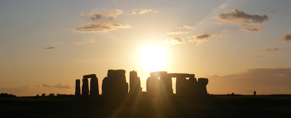


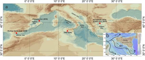
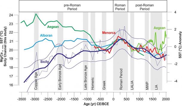
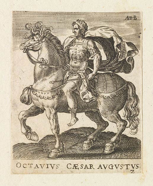
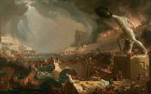
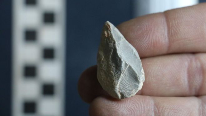
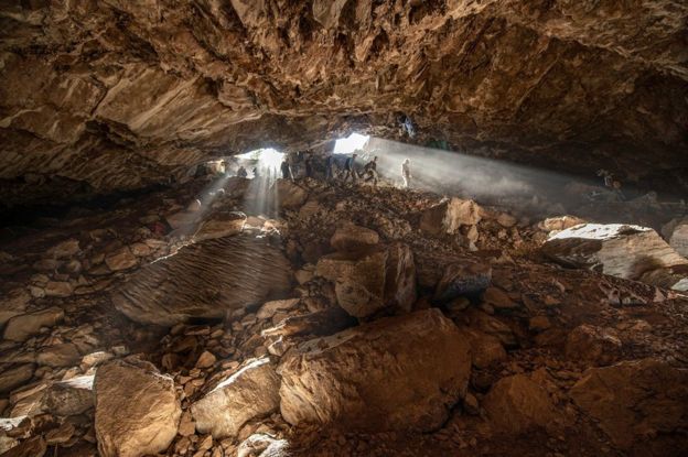
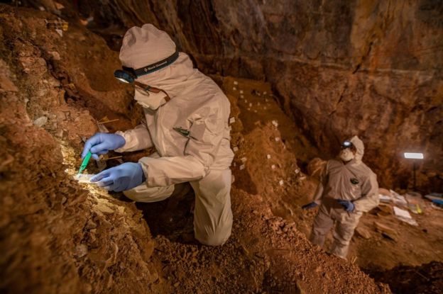


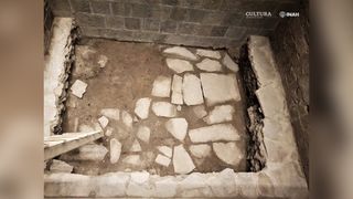


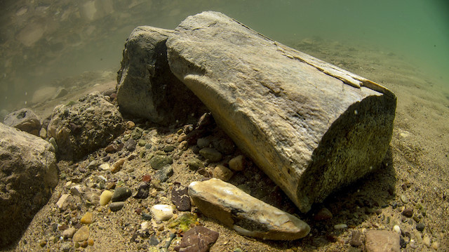
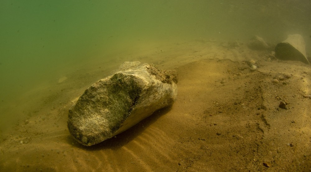
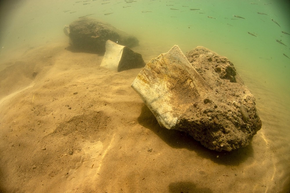


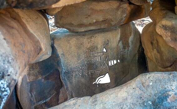
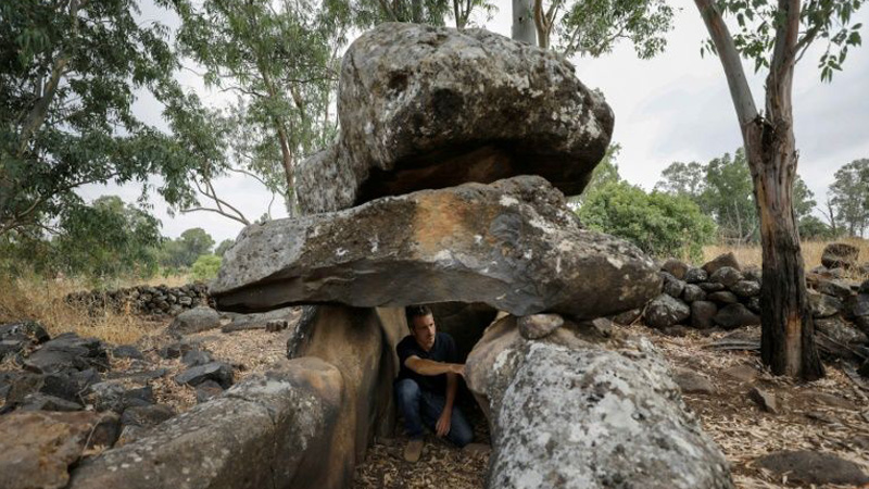
")


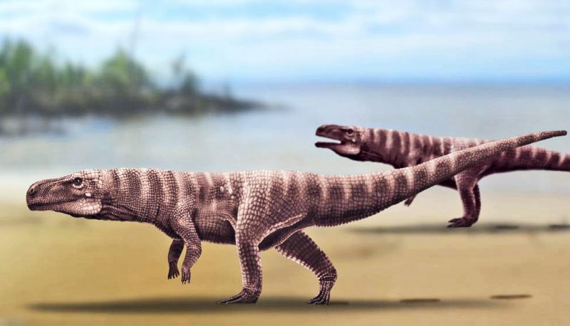
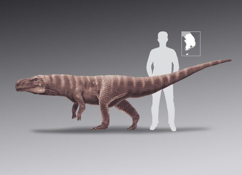
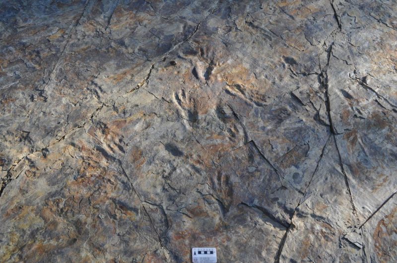

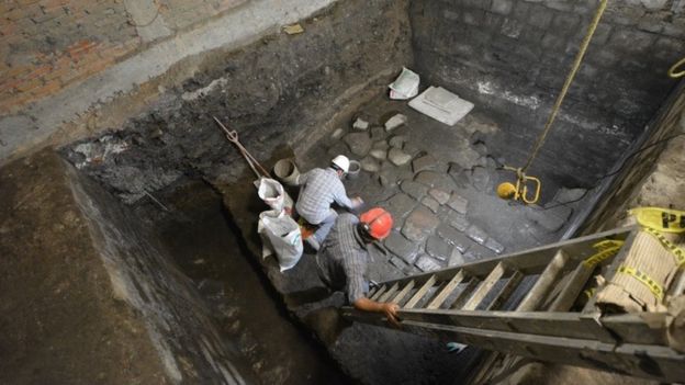
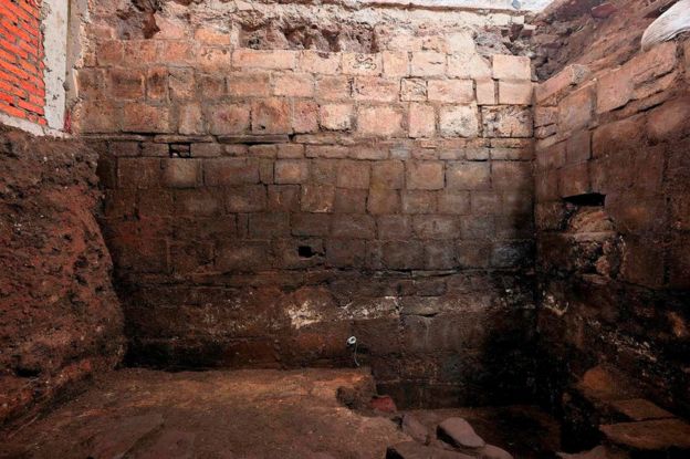

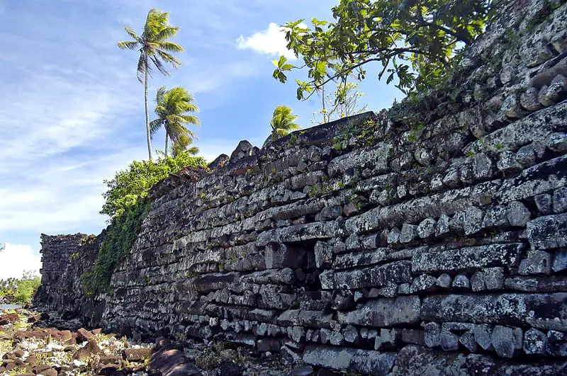


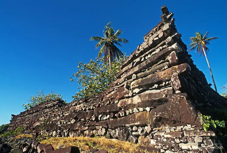


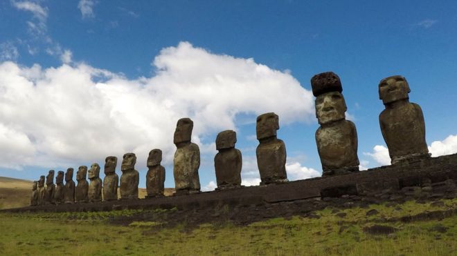
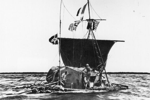

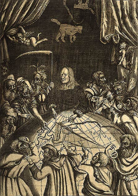
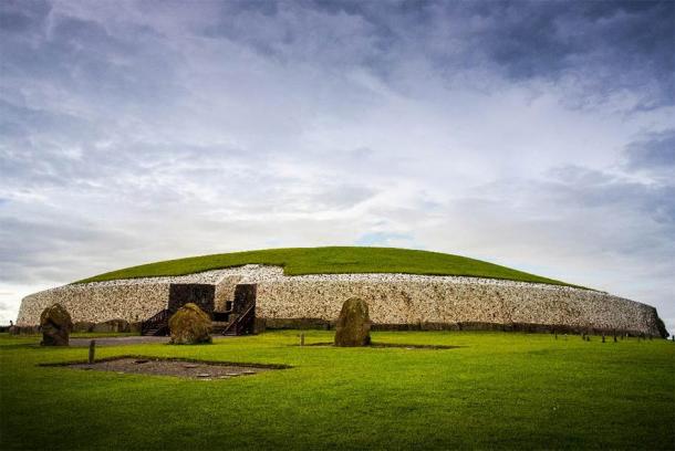
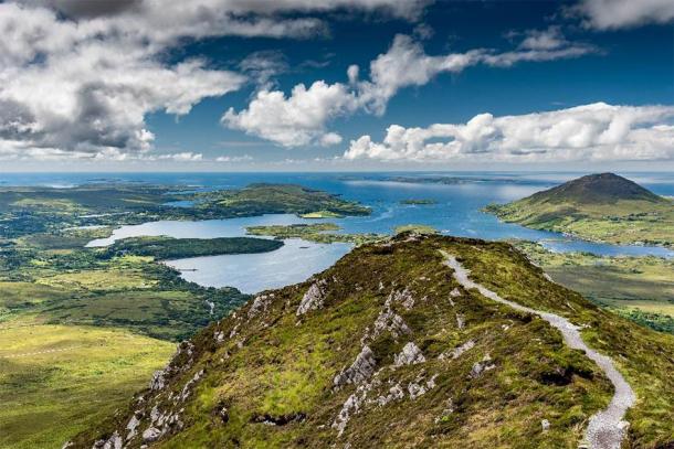
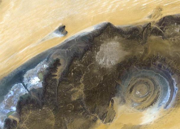
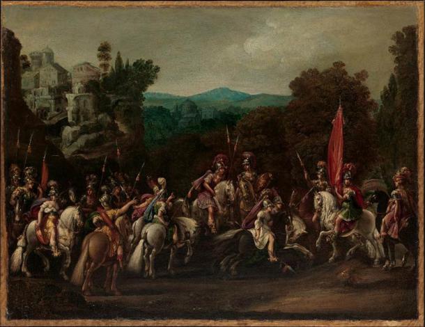


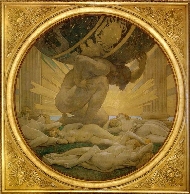
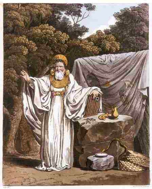
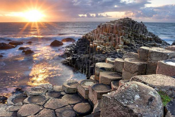
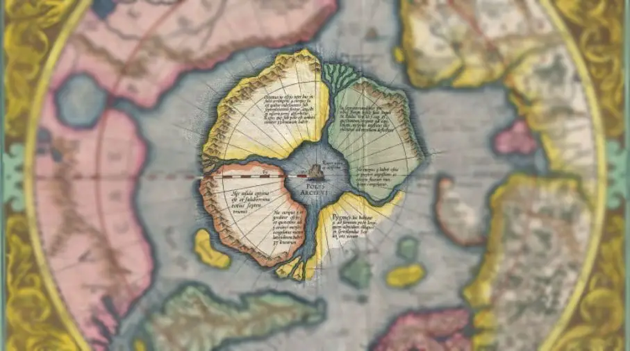
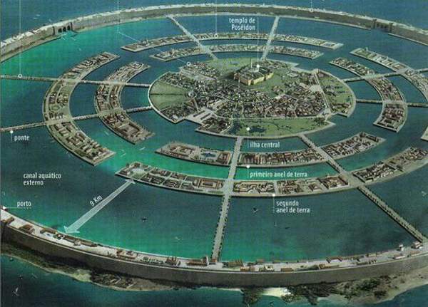
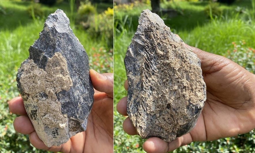

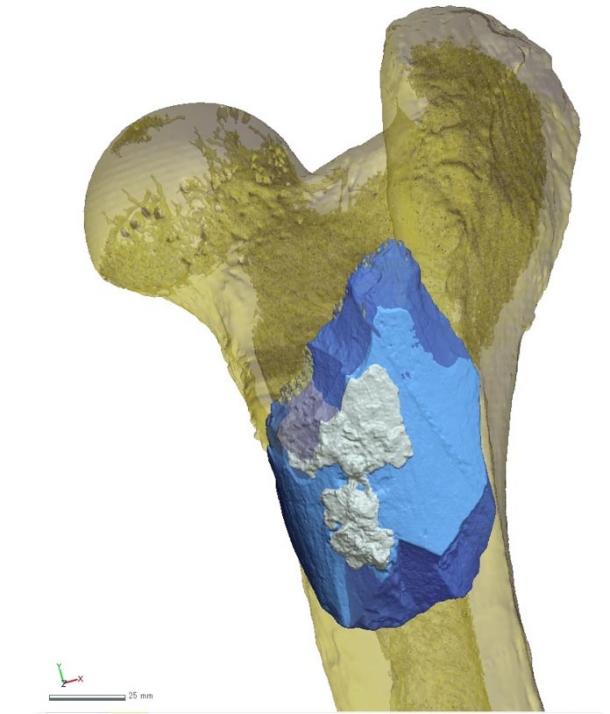


