The purpose of this blog is the creation of an open, international, independent and free forum, where every UFO-researcher can publish the results of his/her research. The languagues, used for this blog, are Dutch, English and French.You can find the articles of a collegue by selecting his category. Each author stays resposable for the continue of his articles. As blogmaster I have the right to refuse an addition or an article, when it attacks other collegues or UFO-groupes.
Druk op onderstaande knop om te reageren in mijn forum
Zoeken in blog
Deze blog is opgedragen aan mijn overleden echtgenote Lucienne.
In 2012 verloor ze haar moedige strijd tegen kanker!
In 2011 startte ik deze blog, omdat ik niet mocht stoppen met mijn UFO-onderzoek.
BEDANKT!!!
Een interessant adres?
UFO'S of UAP'S, ASTRONOMIE, RUIMTEVAART, ARCHEOLOGIE, OUDHEIDKUNDE, SF-SNUFJES EN ANDERE ESOTERISCHE WETENSCHAPPEN - DE ALLERLAATSTE NIEUWTJES
UFO's of UAP'S in België en de rest van de wereld Ontdek de Fascinerende Wereld van UFO's en UAP's: Jouw Bron voor Onthullende Informatie!
Ben jij ook gefascineerd door het onbekende? Wil je meer weten over UFO's en UAP's, niet alleen in België, maar over de hele wereld? Dan ben je op de juiste plek!
België: Het Kloppend Hart van UFO-onderzoek
In België is BUFON (Belgisch UFO-Netwerk) dé autoriteit op het gebied van UFO-onderzoek. Voor betrouwbare en objectieve informatie over deze intrigerende fenomenen, bezoek je zeker onze Facebook-pagina en deze blog. Maar dat is nog niet alles! Ontdek ook het Belgisch UFO-meldpunt en Caelestia, twee organisaties die diepgaand onderzoek verrichten, al zijn ze soms kritisch of sceptisch.
Nederland: Een Schat aan Informatie
Voor onze Nederlandse buren is er de schitterende website www.ufowijzer.nl, beheerd door Paul Harmans. Deze site biedt een schat aan informatie en artikelen die je niet wilt missen!
Internationaal: MUFON - De Wereldwijde Autoriteit
Neem ook een kijkje bij MUFON (Mutual UFO Network Inc.), een gerenommeerde Amerikaanse UFO-vereniging met afdelingen in de VS en wereldwijd. MUFON is toegewijd aan de wetenschappelijke en analytische studie van het UFO-fenomeen, en hun maandelijkse tijdschrift, The MUFON UFO-Journal, is een must-read voor elke UFO-enthousiasteling. Bezoek hun website op www.mufon.com voor meer informatie.
Samenwerking en Toekomstvisie
Sinds 1 februari 2020 is Pieter niet alleen ex-president van BUFON, maar ook de voormalige nationale directeur van MUFON in Vlaanderen en Nederland. Dit creëert een sterke samenwerking met de Franse MUFON Reseau MUFON/EUROP, wat ons in staat stelt om nog meer waardevolle inzichten te delen.
Let op: Nepprofielen en Nieuwe Groeperingen
Pas op voor een nieuwe groepering die zich ook BUFON noemt, maar geen enkele connectie heeft met onze gevestigde organisatie. Hoewel zij de naam geregistreerd hebben, kunnen ze het rijke verleden en de expertise van onze groep niet evenaren. We wensen hen veel succes, maar we blijven de autoriteit in UFO-onderzoek!
Blijf Op De Hoogte!
Wil jij de laatste nieuwtjes over UFO's, ruimtevaart, archeologie, en meer? Volg ons dan en duik samen met ons in de fascinerende wereld van het onbekende! Sluit je aan bij de gemeenschap van nieuwsgierige geesten die net als jij verlangen naar antwoorden en avonturen in de sterren!
Heb je vragen of wil je meer weten? Aarzel dan niet om contact met ons op te nemen! Samen ontrafelen we het mysterie van de lucht en daarbuiten.
09-10-2022
Over 800 Ancient Monuments Found in Polish Forest with LiDAR!
Over 800 Ancient Monuments Found in Polish Forest with LiDAR!
One of the last primeval forests in Europe, Białowieża forest in Poland, is the subject of a fascinating new LiDAR (Light Detection and Ranging) survey. It has yielded a vast and incredible array of hidden treasures from prehistory all the way up until World War II, including 577 ancient burial barrows, 246 charcoal kiln sites, 54 tar plants, 19 complexes of ancient farmlands, 51 semi-dugouts and 17 war cemeteries.
Some of the mounds are dated to the early Middle Ages, but most are from the Roman period, i.e., 2nd – 5th century AD. In total, the 800+ ancient monuments are of various functions, as explained by the team of scientists and archaeologists from the Institute of Archaeology of the Cardinal Stefan Wyszynski University (IA UKSW) in Warsaw.
The project was headed by Prof. Przemysław Urbańczyk. They have brought to a close a lengthy 5 year research project of the Polish half of the Białowieża Forest, which lies on the border with Belarus, reports PAP. The research has been funded by the National Science Center of Poland.
"Thanks to the use of innovative research methods, combined with numerous natural analyzes, we have obtained, despite the initial pessimism, amazing results”, the main project coordinator, Dr. Joanna Wawrzeniek from the IA UKSW told PAP. “In accordance with the current conservation doctrine, we mainly used non-invasive tests. The output information was provided by aerial laser scanning,” she added.
Aerial laser scanning is a highly efficient non-invasive research method, that allows for a comfortable bypassing of the need for archaeological excavations, by allowing a top-down view of the topography. Dense forests and tough terrain do not act as a hindrance and allow for all kinds of structures to be seen and identified – natural and human-made (like burial structures and mounds for example).
The purpose of the ancient barrows in the Polish forest is not certain, but they are thought to be burial mounds. This is where LiDAR’s efficiency draws a line. Therefore, archival queries, geophysical surveys, drilling, and survey research methods were also employed.
Mounds from the Middle Ages contained skeleton and cremation burials, but the ones from the ancient periods lacked human remains, reports Heritage Daily and may have been ritualistic .
Some of the ancient structures spotted with LiDAR in Białowieża Forest in Poland
(M. Szubski, M. Jakubczak)
Occupation Through Time
Earlier on in pre-history, people inhabited the forest on small elevations that had access to a river or a stream, which could be places inhabited for a long time. Evidence of habitation is also gained from two structures, first of which is located in the Strict Reserve of the Białowieża National Park, and the other is in the Wilczy Jar Forest District.
They did not play a defensive role, or act as strongholds, but are more likely to have played some kind of ritualistic role. Only archaeological excavations can provide insight into what this ritualistic role potentially could be.
The first structure that was examined has a diameter of 36 meters (118.1 feet), with a small embankment that is 3 meters (9.8 feet) wide. From this structure, Slavic pottery from the early and late Middle Ages was found, along with ancient flint relics. The second structure was less than half of the first in diameter – 17 meters (55.77 feet). Here, there is evidence of the site being used in two distinct periods – first in prehistory (4th-3rd century BC), and the second from the 7 th-10th century AD.
The second structure had, alongside it, a compact pavement, a shallow pit, and traces of a dowel discovered on the embankment. Also found was the fragment of a courtyard, with lightly burned animal bones in the vicinity. It also possessed a vessel from the Roman period, though there was no other proof of occupation from the Roman period.
Further publications are planned, which will describe the results of this exciting archaeological research, and with over 800 monuments discovered, there is still much to be revealed!
Top image: An ancient burial mound in Poland, Tumuli in Wesiory (representational image). Artur Henryk / Adobe Stock
In Ancient Mesopotamia, Sex Among The Gods Shook Heaven And Earth
In Ancient Mesopotamia, Sex Among The Gods Shook Heaven And Earth
The “Burney Relief,” which is believed to represent either Ishtar, the Mesopotamian goddess of love and war, or her older sister Ereshkigal, Queen of the underworld (c. 19th or 18th century BC).
Credit: British Museum
Sexuality was central to life in ancient Mesopotamia, an area of the Ancient Near East often described as the cradle of western civilisation roughly corresponding to modern-day Iraq, Kuwait, and parts of Syria, Iran and Turkey. It was not only so for everyday humans but for kings and even deities.
Mesopotamian deities shared many human experiences, with gods marrying, procreating and sharing households and familial duties. However when love went wrong, the consequences could be dire in both heaven and on earth.
Scholars have observed the similarities between the divine “marriage machine” found in ancient literary works and the historical courtship of mortals, although it is difficult to disentangle the two, most famously in so-called “sacred marriages”, which saw Mesopotamian kings marrying deities.
Divine sex
Gods, being immortal and generally of superior status to humans, did not strictly need sexual intercourse for population maintenance, yet the practicalities of the matter seem to have done little to curb their enthusiasm.
Sexual relationships between Mesopotamian deities provided inspiration for a rich variety of narratives. These include Sumerian myths such as Enlil and Ninlil and Enki and Ninhursag, where the complicated sexual interactions between deities was shown to involve trickery, deception and disguise.
In both myths, a male deity adopts a disguise, and then attempts to gain sexual access to the female deity — or to avoid his lover’s pursuit. In the first, the goddess Ninlil follows her lover Enlil down into the Underworld, and barters sexual favours for information on Enlil’s whereabouts. The provision of a false identity in these myths is used to circumnavigate societal expectations of sex and fidelity.
Sexual betrayal could spell doom not only for errant lovers but for the whole of society. When the Queen of the Underworld, Ereshkigal, is abandoned by her lover, Nergal, she threatens to raise the dead unless he is returned to her, alluding to her right to sexual satiety.
The goddess Ishtar makes the same threat in the face of a romantic rejection from the king of Uruk in the Epic of Gilgamesh. It is interesting to note that both Ishtar and Ereshkigal, who are sisters, use one of the most potent threats at their disposal to address matters of the heart.
The plots of these myths highlight the potential for deceit to create alienation between lovers during courtship. The less-than-smooth course of love in these myths, and their complex use of literary imagery, have drawn scholarly comparisons with the works of Shakespeare.
Love poetry
Ancient authors of Sumerian love poetry, depicting the exploits of divine couples, show a wealth of practical knowledge on the stages of female sexual arousal. It’s thought by some scholars that this poetry may have historically had an educational purpose: to teach inexperienced young lovers in ancient Mesopotamia about intercourse. It’s also been suggested the texts had religious purposes, or possibly magical potency.
Several texts write of the courtship of a divine couple, Inanna (the Semitic equivalent of Ishtar) and her lover, the shepherd deity Dumuzi. The closeness of the lovers is shown through a sophisticated combination of poetry and sensuousness imagery - perhaps providing an edifying example for this year’s Bad Sex in Fiction nominees.
Ancient Sumerian cylinder seal impression showing Dumuzid being tortured in the Underworld by the galla demons.
Credit: British Museum
In one of the poems, elements of the female lover’s arousal are catalogued, from the increased lubrication of her vulva, to the “trembling” of her climax. The male partner is presented delighting in his partner’s physical form, and speaking kindly to her. The feminine perspective on lovemaking is emphasised in the texts through the description of the goddess’ erotic fantasies. These fantasies are part of the preparations of the goddess for her union, and perhaps contribute to her sexual satisfaction.
Female and male genitals could be celebrated in poetry, the presence of dark pubic hair on the goddess’ vulva is poetically described through the symbolism of a flock of ducks on a well-watered field or a narrow doorway framed in glossy black lapis-lazuli.
The representation of genitals may also have served a religious function: temple inventories have revealed votive models of pubic triangles, some made of clay or bronze. Votive offerings in the shape of vulvae have been found in the city of Assur from before 1000 BC.
Happy goddess, happy kingdom
Divine sex was not the sole preserve of the gods, but could also involve the human king. Few topics from Mesopotamia have captured the imagination as much as the concept of sacred marriage. In this tradition, the historical Mesopotamian king would be married to the goddess of love, Ishtar. There is literary evidence for such marriages from very early Mesopotamia, before 2300 BC, and the concept persevered into much later periods.
The relationship between historical kings and Mesopotamian deities was considered crucial to the successful continuation of earthly and cosmic order. For the Mesopotamian monarch, then, the sexual relationship with the goddess of love most likely involved a certain amount of pressure to perform.
Some scholars have suggested these marriages involved a physical expression between the king and another person (such as a priestess) embodying the goddess. The general view now is that if there were a physical enactment to a sacred marriage ritual it would have been conducted on a symbolic level rather than a carnal one, with the king perhaps sharing his bed with a statue of the deity.
Agricultural imagery was often used to describe the union of goddess and king. Honey, for instance, is described as sweet like the goddess’ mouth and vulva.
A love song from the city of Ur between 2100-2000 BC is dedicated to Shu-Shin, the king, and Ishtar:
In the bedchamber dripping with honey let us enjoy over and over your allure, the sweet thing. Lad, let me do the sweetest things to you. My precious sweet, let me bring you honey.
Sex in this love poetry is depicted as a pleasurable activity that enhanced loving feelings of intimacy. This sense of increased closeness was considered to bring joy to the heart of the goddess, resulting in good fortune and abundance for the entire community — perhaps demonstrating an early Mesopotamian version of the adage “happy wife, happy life”.
The diverse presentation of divine sex creates something of a mystery around the causes for the cultural emphasis on cosmic copulation. While the presentation of divine sex and marriage in ancient Mesopotamia likely served numerous purposes, some elements of the intimate relationships between gods shows some carry-over to mortal unions.
While dishonesty between lovers could lead to alienation, positive sexual interactions held countless benefits, including greater intimacy and lasting happiness.
Written by Louise Pryke - Lecturer, Languages and Literature of Ancient Israel, Macquarie University
Creatures of the Land, Sea and Heavens: Ancient Beliefs in Animal Counterparts
Creatures of the Land, Sea and Heavens: Ancient Beliefs in Animal Counterparts
Until the Age of Enlightenment, it was widely believed that every land creature had its counterpart in the sea (and perhaps even in the heavens). The classic example of this belief is the horse, which in the sea is a seahorse and in the heavens is Pegasus. This debate was waged by some of history’s intellectual heavy weights including Pliny the Elder, Saint Augustine of Hippo, and Sir Thomas Brown. There are even said to be allusions to the issue in the Biblical Book of Job. The belief in marine counterparts on land transcended the religious divisions and was shared by pagans, Christians, and Muslims alike. Unfortunately, such unity of thought was proven to be quite wrong upon a careful examination of the world’s animal and marine life.
The belief that land animals had counterparts in the sea has long been common among the laity. The first person to really articulate the logic of this notion was Pliny the Elder (23 AD – 79 AD) in his encyclopedic Natural History, written in 77 AD. In Book IX (out of 37) Pliny discusses the Natural History of Fishes. In the opening chapter he writes:
“These seeds and first principles of being are so utterly conglomerated and so involved, the one with the other, from being whirled to and fro, now by the action of the winds and now by the waves. Hence it is that the vulgar notion may very possibly be true, that whatever is produced in any other department of Nature, is to be found in the sea as well; while, at the same time, many other productions are there to be found which nowhere else exist. That there are to be found in the sea the forms, not only of terrestrial animals, but of inanimate objects even, is easily to be understood by all who will take the trouble to examine the grape-fish, the sword-fish, the sawfish, and the cucumber-fish, which last so strongly resembles the real cucumber both in color and in smell. We shall find the less reason than to be surprised to find that in so small an object as a shell-fish the head of the horse is to be seen protruding from the shell.”
Pliny the Elder, as imagined by a 19th-century artist.
Pliny’s writings doubtless inspired the unknown author of Physiologus, a didactic Christian text written in 2nd century AD Alexandria. This beautifully illustrated book was one of the most copied manuscripts in Medieval Europe. In it, the author describes various animals, birds, and fish and also gives the moral function of each. Some, such as the Phoenix and Pelican, are good and represent Jesus.
Others, such as the Fox and the Whale, are evil and represent the devil. The allegories for the Fox and the Whale are as follows:
“The fox represents the devil, who pretends to be dead to those who retain their worldly ways, and only reveals himself when he has them in his jaws. To those with perfect faith, the devil is truly dead.” (The Medieval Bestiary, 2011)
These descriptions contributed to the popular science of bestiary in the Middle Ages. The trend supported the superstition that animals on land and sea were paired. If anyone needed further proof, they would be directed to this passage from the Book of Job, which was believed to reveal God’s divine will in designing symmetry among his creations: But ask the animals, and they will teach you; the birds of the air, and they will tell you; ask the plants of the earth, and they will teach you; and the fish of the sea will declare to you. Who among all these does not know that the hand of the Lord has done this? In his hand is the life of every living thing and the breath of every human being.”(Job
Sir Thomas Browne, a British naturalist writing in the 17th century, put an end to the matter in the short but scathing Chapter 24 of his Pseudodoxia Epidemica or Enquiries into very many received tenets and commonly presumed truths, also known simply as Pseudodoxia Epidemica or Vulgar Errors. Browne writes:
“That all Animals of the Land, are in their kind in the Sea, although received as a principle, is a tenet very questionable, and will admit of restraint. For some in the Sea are not to be matched by any enquiry at Land, and hold those shapes which terrestrial forms approach not; as may be observed in the Moon fish, or Orthragoriscus, the several sorts of Rays, Torpedos, Oysters, and many more, and some there are in the Land which were never maintained to be in the Sea, as Panthers, Hyenas, Camels, Sheep, Molls, and others … And therefore, although it be not denied that some in the water do carry a justifiable resemblance to some at Land, yet are the major part which bear their names unlike; nor do they otherwise resemble the creatures on earth, then they on earth the constellations which pass under animal names in heaven: nor the Dog-fish at Sea much more make out the Dog of the Land, then that his cognominal or name-sake in the heavens.”(Browne, 1672)
Title-page of 1658 4th edition of Pseudodoxia Epidemica. ( CC BY-SA 3.0 )
Today, there is little doubt that land and sea animals are distinct. This reflects the progress the natural sciences have made over the last 2000 years.
Top image: Secrets de l'histoire naturelle ( Public Domain )
Browne, Thomas. "Browne's Vulgar Errors III.xxiv: Animals, Land and Sea." Browne's Vulgar Errors. James Eason at the University of Chicago, 1672. Web. 13 Dec. 2016. http://penelope.uchicago.edu/pseudodoxia/pseudo324.html
Mysterious Cases of Living Fossils, Suspended Animation, and Hibernation
Mysterious Cases of Living Fossils, Suspended Animation, and Hibernation
We all know that fossils, by their very nature, are dead. Of course, nothing can survive the conditions of pressure, depth and time required to petrify wood, see saplings mature into massive trees, transmogrify vegetation into coal or metamorphose mud into solid rock. Still, living creatures seemingly from remotest antiquity keep turning up encased in stone from far beneath Earth's surface, embedded inside solid tree trunks and in other situations defying both reason and the gospel of the Great God Science.
Living Fossils Story #1: Ancient Wormhole Mine
One such case occurred April 22, 1881, when miner Joe Molino was working deep in the Wide West Mine outside Ruby Hill, Nevada. When he wedged loose a protruding hunk of stone from the tunnel wall it landed on his foot. Enraged, he grabbed a sledgehammer and smashed it to bits. Molino was stunned to see his hammer blow had exposed a baseball-sized cavity in the rock. It was half full of motionless white worms.
As a crowd of quizzical miners gathered to view the unusual artifacts the worms began to move. Within an hour they were crawling around on the floor of the tunnel.
Mine operators sent the worms (whose species apparently was never determined) and their solid stone sarcophagus to the U.S. Bureau of Mines. Several weeks later the bureau sent the mine operators a letter declaring they must have been mistaken. Since it clearly is impossible for creatures to have survived under the circumstances described, as far as the bureau was concerned there was no way the incident could have happened.
In 1892 an ore nugget found in an Arizona mine was found to contain a dead beetle from which emerged a live beetle: is that a living fossil or what?
Yet more scientific mystery was brewing in the American West when, sometime in 1892, a large beetle was found encased in a chunk of iron ore in the Longfellow Mine outside Clifton, Arizona. The ore nugget and its dead inhabitant were turned over to El Paso geologist Z. T. White, who placed the insect in a specimen case. Several days later he was shocked to see the creature move. Watching through a magnifying glass White saw a small beetle emerge from the body of the larger, dead one. He placed the small beetle in a jar where it lived for several months. When it died, he presented it, the larger beetle and the lump of ore to the Smithsonian Institution , where they may remain to this day.
Living Fossils Story #3: A Load of Bullfrog
Since the vast majority of fossils are buried, it is predictable that mines are the main source of mysterious zoological artifacts. In 1873, miners at the Black Diamond Coal Mine outside San Francisco found a large frog encased in limestone.
This common (but venerable) bullfrog was apparently blind, and able to slowly move just one leg. After several hours on the surface, it died. The frog and its entombing stone were given to the San Francisco Academy of Sciences, where its survival of what would seem an impossible stretch of time continues to defy understanding.
Yet not all living fossils are found in stone or ore.
Once in 1893 in Ontario, Canada a live toad emerged from deep inside a tree trunk!
In October 1893 workmen at the Brown and Hall Sawmill in Ontario, Canada were using a circular saw to cut a large tree trunk into planks when the blade sliced through a cavity containing (and almost cut in two) a live toad imprisoned squarely in the middle of the tree trunk. The tree was about 200 years old, and the spherical, perfectly smooth hole in which the amphibian was entombed was about 60 feet (18 meters) above the ground. The toad tumbled from its wooden prison and hopped away, seemingly none the worse for its long confinement.
Another report of a live toad in a hole comes from England. In 1829 huge granite blocks that had formed a submerged footing under the docks of Liverpool's George's Basin were being cut into small chunks to be made into steps. During one of the cuts, the stone saw revealed a little hole in the middle of a block, and a toad within it.
Workers gently enlarged the hole to free its occupant, and the amphibian made several futile attempts to get to its feet. Several hours later, after trying one last time to assume its normal crouching position, the toad sank to the pavement and died. Several scientists who later examined the small corpse confessed they were at a loss to explain how the animal could have been found alive under such airless, foodless and waterless conditions. One of these learned men took the dead animal home with him, and it was never seen again. It was not the first or last impossible fossil yielded by Britain.
Living Fossils Story #5: Newt News
In 1818 professional geologist Dr. E.D. Clark, who taught at Caius College in Cambridge, Scotland, was present at the digging of a pit on a friend's property when the workmen hit a layer of animated fossils. As one of the workers was breaking up a large chunk of chalk stone into smaller pieces so they could be removed from the hole he found three newts embedded in the rock. Clarke placed them in the bright sunlight and was stupefied when they began to move. Two of them died later in the day, and for years he exhibited them to his students during his lectures on prehistory. He placed the third newt in a nearby brook, and it "skipped and twisted about as though it had never been torpid," and escaped, he later said. Clarke was never able to identify the species to which the newts belonged.
Upon Clarke's retirement he donated the preserved newts to the university's biology department, where, for decades, other professors displayed them during lectures. During the chaos of the 1940 Nazi bombing blitz these pickled specimens turned up missing. Unless they were blown to atoms by a Luftwaffe bomb, they may remain somewhere within Cambridge University, forgotten and still unexplained.
This is a fossil of a flying dinosaur, a Pterodactylus antiquus, and a close cousin of this species was apparently still alive in France in the 1850s according to newspaper reports at the time.
The most incredible find of a living fossil is that reported by the Illustrated London Times of February 9, 1856. The incident occurred in France during the construction of a railway tunnel between the towns of Nancy and St. Dizier. According to the article, workers were breaking up a huge boulder when a goose-sized monster staggered from a freshly exposed cavity and screeched hoarsely before falling dead. It had a long beak, sharp teeth, four legs joined by membranes, and feet with long hooked talons. Its flesh was oily and glossy black.
The mysterious carcass was taken to a paleontologist who instantly recognized the animal as a Pterodactylus anas, a denizen of the Jurassic Period , which ended 135 million years ago. There is no record of whether the body was preserved and still exists.
Possibilities
Certain animals' ability to live long stretches without sustenance is possible via hibernation to escape the lean, hostile conditions of winter. Because their metabolisms are conditioned to arouse them upon the advent of the warmth and renewed food supplies of springtime, they are seldom in suspended animation for more than four or five months. What might happen if spring never arrived? What if their hibernation dens were to be buried by glaciers and/or metamorphose into rock?
Southern Methodist University professor of biology Dr. John Ubelaker, Ph.D. points out that many organisms possess the ability to lower their metabolisms, and that this function is often triggered by environmental conditions. This permits survival through difficult times.
"This is a common phenomenon among many free-living nematodes that have the ability to form a resting stage--dauer larvae--in order to survive a stressful situation," he says. "In these nematodes the ability to control water and water loss is critical, and several metabolic-biochemical processes operate."
Nematodes that have come to life are perhaps the most incredible living fossils. A colorized electron micrograph of a soybean cyst nematode and egg.
In his 1863 book History of the Supernatural noted British author and scientist William Hewitt recounted a midsummer incident he had personally witnessed several years earlier in which workmen in Nottinghamshire, England were digging a ditch and unearthed what he called "a regular stratum of frogs." The creatures were not only alive, but so animated they all hopped away.
He described the layer of mud that had held the frogs as "stiff as butter," and based on the time of year and his examination of the ground where they were buried, he estimated they had been there at least six months. As he asked his readers, "If these frogs could live six months in this nearly solid casing of viscous mud, why not six or any number of years?"
Ubelaker expands upon this premise:
"An interesting fact of life is that an organism's structure and composition can remain virtually the same even though it continuously takes in nutrients and produces wastes. Often defined as a dynamic equilibrium, life allows concentrations of the mixture of the materials in an organism to remain constant even though individual molecules are constantly shifting back and forth, increasing or decreasing in a short time scale," he says."Remember that an organism at equilibrium is dead. A common classroom comparison is often made with a river and the steady state condition of organisms--the river maintains the same level and shape even though water is constantly flowing through it. Rivers rise and change course, drop to low levels depending on the available water, but at any one point it (and its concentration of materials) remains quite constant. In organisms the structure, proteins, nucleic acid, lipids stay relatively constant even though no one molecule remains in any pool for long."
The erratic and odd sides of the natural world remind us of how much we still have to learn about Mother Earth and the processes that govern her and her multitude of children. There are doubtless many more living relics of the primordial past awaiting exhumation. When they do come to light, they should be studied meticulously in order to ascertain how they survived such extremes of time, temperature and deprivation. The possibility of harmlessly subjecting human beings to suspended animation could solve problems of surviving extended space travel, awaiting the return of loved ones from the stars, outlasting terminal illnesses until cures are discovered, or simply staying alive long enough to meet one's great-great-great-grandchildren. Before we can even start on such grand aspirations, however, we must admit this potentially priceless process exists.
Top image: Frog brooch of amber and bronze on a rock, representative of living fossils.
Eridu: The Sumerian Garden of Eden and the Oldest City in the World?
Eridu: The Sumerian Garden of Eden and the Oldest City in the World?
Today, Eridu is often considered to be one of the oldest permanent settlements in Mesopotamia, and perhaps even in the world. The ancient Sumerians also believed that Eridu was the first city in the world and they documented that belief in the Sumerian King List and the Eridu Genesis . At least 18 layers of settlement are found at the site, could the ancient Sumerian belief be possible?
Archaeological evidence shows that the earliest structures date to the 6th millennium BC. The city reached its zenith during the 4th millennium BC and continued to be inhabited until around the 7th century BC. By then, however, the city had lost its importance.
Some of the baked bricks used in the construction of the Sumerian ziggurat at Eridu, southwest of Nasiriyah, Iraq, are stamped with the name of King Ur-Nammu (2123-2106 BC).
Eridu (known today as Tell Abu Shahrain) is located about 20 km (12.5 miles) to the southwest of the famous city of Ur. As its modern name indicates, the archaeological site is a tell, which is a huge mound formed over the millennia as a result of new settlements being built over the ruins of the previous ones. The tell rises to a height to 7 meters (23 feet), and is formed by 18 levels of occupation, according to the archaeological excavations. The bulk of this has been dated to the Ubaid and Uruk periods, which lasted from the 6th to 4th millennia BC.
The ancient Sumerians themselves made mention of Eridu’s antiquity. In the Sumerian King List , for example, it is written that “After the kingship descended from heaven, the kingship was in Eridug.” In addition, in the creation myth known as the Eridu Genesis , it is said to have been one of the five cities that existed before the Deluge, the others being Bad-Tibira, Larak, Sippar, and Suruppak.
The God of Eridu Temple
The patron god of Eridu was Enki (known also in Akkadian as Ea), the god of water. According to Sumerian mythology, the settlement was founded by Enki, and it was from this city that civilization was spread to other parts of the land. Although Enki was initially a local god, he rose in importance as the city grew in influence, resulting in him being incorporated into the pantheon of other cities as well. In Eridu, Enki’s temple is known as E-Abzu (Abzu may be translated as ‘Deep Ocean’, and refers to the underground spring from which all life is believed to have begun).
Rough map of the Eridu mound showing the main ziggurat, temple, and a few buildings.
Archaeological excavations of the E-Abzu have revealed that the temple began as a small room containing what has been referred to by scholars as a ‘cult niche’ and an ‘offering table’. Over the millennia, however, the inhabitants built new temples over the ruins of the old ones, each bigger than the last. The E-Abzu eventually became a large ziggurat, an apt reflection of Enki’s status as a major deity. It has been proposed that the E-Abzu may have been the largest of the ancient Mesopotamian ziggurats.
Economic Activities
Although the E-Abzu is the focal point of the site’s archaeology, there are either elements of interest. More recent excavations, for instance, have revealed that during the Ubaid period, the city was a pottery production center. This is evident in the pottery works, which had large scatterings of pottery fragments and kiln waste. Additionally, remains of fishing nets, weights, and even models of reed boats have been found at the site, suggesting that fishing was a major economic activity carried out by the inhabitants.
There are nine lines of cuneiform inscriptions on this fired clay brick; stamp of the king Amar-Sin (Amar-Suen, previously misread as Bur-Sin), king of Ur. 2100-2000 BC. From Eridu (modern-day Tell Abu Shahrain), southern Mesopotamia, Iraq. It is currently housed in the British Museum in London.
(Osama Shukir Muhammed Amin FRCP(Glasg)/ CC BY SA 4.0 )
Eridu was the dominant city in southern Mesopotamia during the Ubaid period, but it was eventually superseded by Uruk. Nevertheless, it continued to be revered as the first city, and it retained its religious significance thanks to the E-Abzu.
It has been suggested that ecological changes, i.e. the recession of the gulf coast and the increasingly unreliable water table, were responsible for the decline of Eridu around the end of the 3rd millennium BC. The city continued to be inhabited up until around the 7th century BC, although by then it had become a mere shadow of its former glory.
In 2016, Eridu was inscribed as a UNESCO World Heritage Site, as part of the ‘Ahwar of Southern Iraq: Refuge of Biodiversity and the Relict Landscape of the Mesopotamian Cities’.
Top image: Re-creation of the port at Eridu. Source: Public Domain
The Amarnaperiod (1347 – 1336 BC) was undoubtedly one of the most unique stages in the history of ancient Egypt. The establishment of the Egyptian capital in a totally virgin territory so far, the artistic revolution in the representations of the pharaoh and his family or the changes introduced in the religious world are some of its most important aspects, but not the only ones.
At the end of the 19th century, a peasant woman discovered by chance the so-called Amarna letters, an archive of contemporary documentation to Amenhotep III (1390 – 1352 BC) and Amenhotep IV / Akhenaten (1352-1336 BC) which has become a great treasure of Egyptology.
In this article we are going to try to summarize what the Amarna letters are, what are the themes that their contents deal with or who are the protagonists who speak to us through them.
What are the Amarna Letters?
Around 1347 BC, in his fifth year as sovereign, Amenhotep IV took a radical turn in his reign by changing his name: he was renamed Akhenaten, which literally means ” one who effectively acts for the good of Aten.”
As part of his revolutionary program, the pharaoh moved the capital of the country to a newly created city in a territory never before inhabited: Tell el-Amarna, originally known as Akhetaten, that is, “horizon of Aten”.
At the same time that thousands of people of different conditions moved to live in Amarna, so did the main officials of the kingdom.
With them traveled the documents that would make up the great Tell el-Amarna archive, located in the so-called House of Correspondence of the Pharaoh.
The missives in the Amarna archive are engraved in cuneiform script and in Akkadian, one of the lingua francas for international relations.
The language used in these clay tablets flees from formalities and goes into directly analyzing issues such as the political situation of the kingdoms, marital alliances, disputes and diplomatic cordialities, war reports…
To reach their destination, they were transported by officials who sometimes had to walk hundreds of kilometers to fulfill their mission.
The discovery of the first letters occurred fortuitously during the illegal excavations that Farag Ismain was carrying out in the area in mid-1887.
Shortly after, the excavations of the Egyptologist William Flinders Petrie began to bring to light new custom letters that the remains of the Pharaoh’s House of Correspondence were identified.
We do not know the approximate number of tablets that it must have housed at the peak of the Amarnian period, but at present we conserve about four hundred which are distributed between the British Museum in London, the Old Museum in Berlin and the Museum in Cairo.
Contents of the Amarna letters
The fundamental factor that makes the Amarna archive so valuable is its uniqueness, since it is the only set of diplomatic texts that the Nile civilization has bequeathed to us.
The letters are an exceptional testimony of Egypt’s international relations with the great powers of the Middle East from the end of the reign of Amenhotep III, the entire reign of Akhenaten and the beginning of that of Tutankhamun (1336 – 1327 BC).
The scribes who were in charge of writing the Amarna letters that the ambassadors would later carry also played a fundamental role, often working as translators.
After all, the accuracy of the translation depended on whether the message arrived exactly as it should. An incorrect intonation or a badly translated word could generate a misunderstanding that could lead to an international conflict.
Example of five Amarna letters exhibited in the British Museum in London
What are the Amarna letters about?
Within the Amarna letters, one of the requests that is repeated the most, on the part of the pharaoh, is that of princesses and servants of foreign courts.
This marriage circuit was not reciprocal, since the Egyptian sovereign showed his desire to marry Asian princesses while making it clear that he was not willing to send any of his daughters out of the kingdom
However, that does not mean that they did not achieve anything. In the case of Babylon, for example, we know that they sent princesses to Egypt in exchange for large amounts of gold .
Let’s see to finalize some specific cases. One of the Amarna letters indicates that Amenhotep III requested the hand of Princess Kiluhepa of Mittani. The princess then moved to Egypt accompanied by more than three hundred servants.
Another letter specifies the long list of goods that the Mittanian king Tushratta (approx. 1375-1350 BC) contributed as a dowry to his daughter Taduhepa , who eventually traveled with 300 men and women for her personal service.
In another, King Burna-Buriash II of Babylon(approx. 1359 – 1333 BC) complained about the little pomp with which he had transferred his daughter to the country of the Nile, as if she were anybody.
Also angry, Kadashman-Enlil I of Babylon (1374 – 1360 BC) showed his indignation to Amenhotep III for not wanting to give one of his daughters as a wife.
In conclusion, the Amarna letters allow us to peek through a knowledge gap into a world of kings, princesses, courts and entanglements that we could not have accessed through archeology or the texts that were represented in stelae, temples, tombs or palaces.
For all these reasons, this archive is one of the most relevant sources of knowledge that we have when it comes to reconstructing the relationship of political forces existing in Egypt and the Middle East in the 14th century BC in particular and in the Egyptian New Kingdom in general.
Source:
GOLVIN, JC (2017): Cities of the ancient world. Madrid: Wake up Ferro.
LIVERANI, M. (2012): The ancient East. History, society and economy. Barcelona: Criticism.
LULL, J .: “The Amarna archive: the Pharaoh’s letters”, in National Geographic History, nº 193, pp. 38-49.
PADRÓ PARCERISA, J. (2019): History of Pharaonic Egypt. Madrid: Editorial Alliance.
SHAW, I. (2014): History of Ancient Egypt. Madrid.
Fragment of one of the letters between King Tushratta of Mittani and the Egyptian pharaoh
Tablet containing a letter between King Burna-Buriash II of Babylon and the Egyptian pharaoh
A Mysterious Round Structure Older Than Stonehenge Found in Prague
A Mysterious Round Structure Older Than Stonehenge Found in Prague
Paul Seaburn
The beautiful city of Prague in the Czech Republic is known for its rich history, Gothic cathedrals, medieval squares, art scene, nightlife and restaurants. On the other hand, its name rarely comes up when the discussion turns to ancient monuments and monoliths like the Great Pyramid of Giza or Britain’s Stonehenge. That may change soon as the world learns of the discovery of mysterious round monumental building on the outskirts of the city that dates back to about 4900 BCE – making it older than the Great Pyramid and Stonehenge. And, despite being well-preserved, its purpose to the people living there in the Neolithic period is a mystery.
A reconstruction of circular ditches similar to the roundels in this story (piblic domain)
“Roundels were built during the Stone Age when people had not yet discovered iron. The only tools they could use were made of stone and animal bones.”
Despite being erected by people of the New Stone Age using stone and bone tools, Jaroslav Rídký from the Institute of Archaeology of the Czech Academy of Sciences in Prague marvels that the “roundel” – a circular enclosure (‘rondely’ in Czech) – discovered recently in the Vinoř district on the outskirts of Prague is in such ‘monumental’ condition for its age of 7,000 years. Roundels are actually common structures in Central Europe – about 200 have been uncovered in total, with 35 in the Czech Republic. Despite their size, most tourists and even many Europeans have never heard of them.
“The so-called roundels are the oldest evidence of architecture in the whole of Europe. They are a series of circular ditches and they are always arranged in a circle with two, three, four or more entrances to the center, four being the most common.
The whole structure reaches an average of between 30 to 240 meters, but you most commonly find them in the range of 60 – 80 meters.”
Jaroslav Rídký has seen roundels reaching 787 feet (240 meters) in diameter, but the newest discovery in is 180 feet (55 meters) across. (Photos of it here.)
An aerial view of the Vinoř roundel near Prague, showing three separate entrances.
(Image credit: Institute of Archaeology of the Czech Academy of Sciences)
Archaeologists working on the excavation of the Stone Age roundel.
(Image credit: Institute of Archaeology of the Czech Academy of Sciences)
Open trenches undergoing excavation by a team from the Institute of Archaeology of the Czech Academy of Sciences.
(Image credit: Institute of Archaeology of the Czech Academy of Sciences)
A trench wall revealing stratigraphy (different layers) of the excavation.
(Image credit: Institute of Archaeology of the Czech Academy of Sciences)
The “ditches” – all that is left of the mysterious structures – average about one and a half meters (5 feet) in width but some of the largest span fourteen meters (46 feet) and are six meters (20 feet) deep. Only a few of the roundels discovered are well-defined – most are mere outlines of where the ditches once were. That explains why the first ones weren’t discovered until the 19th century and most were unknown until the 1980s with the advent of aerial photography, using drones and planes, and satellite imagery. As they were uncovered, the first mystery of the roundels emerged – virtually all of them across Central Europe were built during a brief 300 year period between 4900 and 4600 BCE. Here is how Jaroslav Rídký describes it:
“There was simply some kind of societal change, where the roundels could no longer fulfill the function they had before and they just stopped being used.
The structure of settlements changes in some areas, the ornamentation changes.”
What happened to cause Neolithic cultures across Central Europe to abandon such huge round structures they spent so much time building and maintaining? The largest (787 feet) is in the Czech Republic and is a series of three concentric ditches with a fourth apparently under construction when it was abandoned. The massive structure had four gates leading to the center. In addition, a second single-ditch roundel was located a mere 165 feet (50 meters) away. Another Czech Republic roundel recently located in Třebovětice in the Jičín district was hidden in a thick forest and, back in its time, was protected by ramparts (fortifying barriers) which are still visible today. It is details like these, along with the discoveries of more roundels like the one in the Vinoř district, which give Miroslav Kraus, the principal investigator of that roundel for the Institute of Archaeology of the Czech Academy of Sciences (IAP), some hints to their mysterious purpose.
“One of such theory is that it could have been used as an economic centre, a centre of trade. It could also have been a centre of some religious cult, where rites of passage or rituals connected to the time of year were performed.”
Kraus and others believe that some of the Czech roundels – and possibly more elsewhere -- were built by the so-called Stroked Pottery culture noted for making zig-zag bands on its pottery vessels. The Stroked Pottery culture existed in Poland, eastern Germany and the northern Czech Republic between 4900 and 4400 BCE, but were more known for building longhouses -- large, rectangular buildings that held 20 to 30 people. If the roundels were built the same way, the inner ditches would have been lined with wooden poles with mud between the gaps. These tightly-erected poles may have been protective fortress walls, but they could also have been load-bearing walls to hold roofs also made with wood like the longhouses. The research team is continuing to comb the area for clues.
A sketch of the layout of the Goseck circle, a similar roundel
Organic material found at the site are being carbon-dated to determine exactly when the Czeck roundel was built and if the builders were indeed part of the Stroked Potter culture. If the roundel was for social gatherings or ritual functions, the organic materials should show where the people gathering there came from, since they appear to have been too large to serve just the local population. It would be impressive to find that these Late Stone Age people living 7000 years ago – before Stonehenge or the Great Pyramid – built such impressive structures for socio-ritual purposes rather than just religious – commemorating events such as rites of passage, astronomical occurrences or economic activities. All of this was done by people working with stone and bone tools.
Who were the people of these Czech roundels? What were their purposes? How did they build them? Why did the suddenly and mysteriously abandon them? If we can answer any or all of these questions, perhaps we can apply that knowledge to other mysterious civilizations which have flourished, then vanished. Perhaps we can find some solutions to our own problems before we vanish as well.
It will be just our luck that the research into the roundels of the Czech Republic will show their builders left because of climate change.
40,000-year-old star maps with sophisticated knowledge of modern astronomy
40,000-year-old star maps with sophisticated knowledge of modern astronomy
In 2008, a scientific study revealed an astonishing fact about the palaeolithic humans ― a number cave paintings, some of which were as old as 40,000 years, were actually products of complex astronomy that our primitive ancestors had acquired in the distant past.
Some of the world’s oldest cave paintings have revealed how ancient people had relatively advanced knowledge of astronomy. Animal symbols represent star constellations in the night sky, and are used to mark dates and events such as comet strikes, analysis from the University of Edinburgh suggested. Credit: Alistair Coombs
The ancient paintings that were thought to be symbols of prehistoric animals are actually ancient star maps, according to what experts revealed in their fascinating discovery.
Early cave art shows that people had an advanced knowledge of the night sky in the last ice age. Intellectually, they were hardly different from us today. But these particular cave paintings revealed that humans had a sophisticated knowledge of stars and constellations more than 40,000 years ago.
It was during the Paleolithic Age, or also called the Old Stone Age ― a period in prehistory distinguished by the original development of stone tools that covers almost 99% of the period of human technological prehistory.
Ancient star maps
According to the breakthrough scientific study published by the University of Edinburgh, ancient humans controlled the passage of time by watching how stars change positions in the sky. The ancient works of art, found in various places in Europe, are not simply representations of wild animals, as previously thought.
Instead, animal symbols represent constellations of stars in the night sky. They are used to represent dates, marking events like asteroid collisions, eclipses, meteor showers, sunrise and sunset, solstices and equinoxes, lunar phases and etc.
The Lascaux cave painting: 17,000 years ago, the Lascaux painters offered the world a peerless work of art. However, according to a new theory, some of the paintings could also be the representations of the constellations as seen in the sky by our ancestors from the Magdalenian era. Such a hypothesis, confirmed in many others Paleolithic Caves radically transforms our conception concerning prehistoric Rock Arts.
Scientists suggest that ancient peoples perfectly understood the effect caused by the gradual change in the Earth’s axis of rotation. The discovery of this phenomenon, called the precession of the equinoxes, was previously credited to the ancient Greeks.
One of the lead researchers, Dr Martin Sweatman, from the University of Edinburgh explained, “Early cave art shows that people had an advanced knowledge of the night sky in the last ice age. Intellectually, they were no different from us today. Tese findings support a theory of multiple impacts of comets throughout human development and are likely to revolutionize the way prehistoric populations are viewed.”
Sophisticated knowledge of constellations
Experts from Edinburgh and Kent universities studied a number of renowned arts in ancient caves located in Turkey, Spain, France and Germany. In their in-depth study, they had achieved the era of those rock arts by chemically dating the paints used by ancient humans.
Then, using computer software, the researchers predicted the position of the stars exactly when the paintings were made. This revealed that what may have appeared before, as abstract representations of animals, can be interpreted as constellations as they arose in the distant past.
Scientists concluded that these incredible cave paintings are a clear evidence that ancient humans practiced a sophisticated method of timing based on astronomical calculations. All of this, although the cave paintings were separated in time by tens of thousands of years.
“The oldest sculpture in the world, the Lion-Man from the Hohlenstein-Stadel cave, from 38,000 BC, was also considered compatible with this ancient timing system,” revealed experts in a statement from the University of Edinburgh
The Löwenmensch figurine or Lion-man of the Hohlenstein-Stadel is a prehistoric ivory sculpture discovered in the Hohlenstein-Stadel, a German cave in 1939. It’s nearly 40,000 years old.
The mysterious statuette is believed to commemorate the catastrophic impact of an asteroid that occurred around 11,000 years ago, initiating the so-called Younger Dryas Event, a period of sudden cooling of the climate worldwide.
At around 12,000 years old, Göbekli Tepe in south-east Turkey has been billed as the world’s oldest temple. Various animal arts can also be seen in this prehistoric site, and the ‘Vulture Stone’ (down-right) is significantly one of them.
“The date carved in the ‘Vulture Stone’ of Göbekli Tepe is interpreted as being 10,950 BC, within 250 years,” explained the scientists in the study. “This date is written using the precession of the equinoxes, with animal symbols representing stellar constellations corresponding to this year’s four solstices and equinoxes.”
Conclusion
So, this great discovery reveals the truth that humans had a complex understanding of time and space thousands of years before the ancient Greeks, who are credited with the first studies of modern astronomy. Not only these, there are several other instances, such as the Sumerian Planisphere, the Nebra Sky Disk, Babylonian Clay Tablet etc., which imply more sophisticated knowledge of modern astronomy that our ancient ancestors once acquired.
The Great White Pyramid of Xian: Why China keeps its pyramids a secret?
The Great White Pyramid of Xian: Why China keeps its pyramids a secret?
The White Pyramid myth began during World War II, when eyewitness accounts, especially from pilot James Gaussman, mentioned the appearance of a massive “White Pyramid” near the Chinese city of Xi’an, during a flight between China and India in 1945, he is believed to have seen a white jewel-topped pyramid.
Not only was this amazing structure supposed to be the biggest pyramid in the world, but it was also said to be surrounded by dozens of smaller pyramids, some rising to almost the same height.
Walter Hain, an author, and scientific writer describe Gaussman’s initial view of the pyramid in his homepages. James Gaussman was returning to Assam, India, after flying the ‘Burma Hump,’ which transported supplies from India to Chungking, China, when engine difficulties caused him to momentarily descend to a low altitude above China.
“I banked in order to avoid a mountain, and we emerged into a flat valley. A gigantic white pyramid stood directly below. It appeared to be something from a fairy tale. It was enclosed in a gleaming white shell. This might have been made of metal or a type of stone. On both sides, it was pure white.
The capstone was amazing; it was a massive chunk of jewel-like material that may have been crystal. We could not have landed, no matter how badly we wanted to. We were taken aback by the enormity of the thing.”
The New York Times picked up the story and published an article on the pyramid on March 28, 1947. Colonel Maurice Sheahan, director of Trans World Airlines’ Far Eastern division, stated in an interview that he had seen a massive pyramid 40 miles southwest of Xian. The same newspaper published a photo two days following the report, which was eventually credited to Gaussman.
Photographs of the massive pyramid he had shot would not be released for another 45 years. Even his report would remain buried in the Secret Service archives of the United States military until then. Numerous researchers and explorers have attempted to locate the White Pyramid of Xi’an, but none have been successful.
Some claim that the White Pyramid may be hidden amidst the high mountains and deep gorges of the Qin Ling Mountains.
Chinese government designated about 400 pyramids north of Xi’an in 2000, however, the White Pyramid was not included. Many of the other sites were excavated, revealing mausoleums shaped more like Mesoamerican pyramids, which vary from Egyptian pyramids in that they are flat-topped and covered with flora.
Ancient members of China’s royal class were buried in these burial mounds, where they planned to lie in peace for eternity. The majority of the pyramids are exceedingly difficult to spot, as they are hidden by lush hillsides and hills, as well as long grass and trees. Only a few of the structures have been made available to tourists.
Photograph published in New York Times, May 30 1947, supposedly taken by James Gaussman
The Chinese government has provided easy justifications for why no one is permitted to enter, notably that enthusiastic archaeologists and visitors may do damage to the relics.
Officials believe they are waiting for technology to improve sufficiently to fully dig the pyramids and their valuable contents. After all, some of the pyramids are thought to be as old as 8,000 years.
Westerners have speculated endlessly about the pyramids’ purpose and energy, as well as their astrological significance. According Noopept stock to scholars, “the cardinal points of North, South, East, and West were all significant to certain kings.” Lining up your tomb with the axis of the world was proof that you were still number one.”
One of the rarest pictures of pyramids in the Xi’an Valley
The most common conspiracy theory includes extraterrestrials, who are said to be the original architects. Is it feasible that Erich von Däniken’s and others’ ancient astronaut theories might also apply to the Chinese pyramids? Wherever there is concealment, conspiracy theories automatically emerge.
The Phoenicians: Mysterious Merchant Mariners Whose Inventions Impacted the World Forever
The Phoenicians: Mysterious Merchant Mariners Whose Inventions Impacted the World Forever
The Phoenicians were an ancient people who once ruled the Mediterranean. Despite little being known about them as very few of their inscriptions have survived, their legacy has had an enormous impact on the world, which is still felt today.
The Phoenicians were renowned as excellent mariners and used their expertise to trade all across the Mediterranean. One of the most notable signs of their trade activity is the establishment of Carthage, in present day Tunisia. They were also the inventors of the alphabet.
The History of the Phoenicians
According to tradition, the city was founded as a colony in 814 BC by Phoenicians under the leadership of the legendary Queen Dido . The Carthaginians themselves became a dominant maritime power in the western Mediterranean, until its final destruction by Rome in 146 BC, following their defeat in the Punic Wars . Apart from Carthage, the Phoenicians founded colonies on Cyprus and in Anatolia as well.
The greater part of the territory they once occupied corresponds to modern day Lebanon, but the Phoenicians also held parts of southern Syria and northern Israel.
The Phoenician Alphabet
The Phoenicians made numerous contributions to human civilization, the most notable of which being the Phoenician alphabet , which is the ancestor of many other alphabets that are used today. Scholars have speculated that the Phoenicians referred to themselves as ‘Kena’ani’ (‘Kinahna’ in Akkadian, or ‘Canaanite’ in English). Interestingly, in Hebrew, this word also meant ‘merchant’, which is an apt description of the Phoenicians. The term ‘Phoenicians’, however, is commonly used today, as it was the Greeks who called these people by this name.
The ancient Greeks referred to the land of the Phoenicians as ‘Phoiniki’, which is derived from the Egyptian ‘Fnkhw’, meaning ‘Syrian’. The Greek ‘Phoiniki’ is phonetically similar to their word for the color purple or crimson (‘phoînix’). This is due to the fact that one of the most valuable objects produced and exported by the Phoenicians was a dye known as Tyrian purple. Thus, the Phoenicians were known also as the ‘Purple People’.
According to the Greek historian Herodotus, the Phoenicians were originally from the Red Sea area, but later emigrated to and settled along the eastern coast of the Mediterranean. Archaeologists today, however, regard Herodotus’ account of the Phoenicians’ origins as a myth. In addition, there is a lack of evidence to support the claims that the Phoenicians emigrated to the eastern Mediterranean from other areas of the ancient world. Instead, it is accepted that the Phoenicians were originally from the eastern Mediterranean and may have developed from the Ghassulian culture, which is an archaeological stage in southern Palestine dating to the Middle Chalcolithic period, i.e. the 4 th millennium BC.
The Phoenicians Flourish as Traders
The Phoenicians flourished during the 1 st millennium BC. During that time, there were other Canaanite cultures inhabiting the region as well, and archaeologists are unable to differentiate between the Phoenicians and these other cultures in terms of material culture, language, and religious beliefs. This is due to the fact that the Phoenicians were themselves Canaanites. Nevertheless, the Phoenicians distinguished themselves from their Canaanite brethren by their achievements as seafarers and traders.
The Phoenicians flourished as marine merchants. (Baddu676 / Public Domain )
As mentioned before, the Greek ‘Phoiniki’ is associated with the dye known as Tyrian purple, which was traded by the Phoenicians. Indeed, this was one of the best-known products of Phoenicia. Tyrian purple was a highly-prized dye that was made using several species of sea snails belonging to the Muricidae family (commonly known as murex snails). One legend states that it was the Greek hero Hercules who discovered this dye. According to this tale, Hercules was strolling along the beach with a nymph, Tyrus, and his dog. Hercules’ dog came across a murex shell and devoured it. When the dog returned to its master its mouth was stained a brilliant purple.
Tyrus found the color so attractive that she requested from Hercules a robe of the of the same color as the price for her hand in marriage. Hercules obliged and gathered enough murex snails to produce the dye necessary to color Tyrus’ robe. In reality, however, Tyrian purple was discovered by the Phoenician. Although nobody is certain today as to how the dye’s discovery was made, it is entirely possible that it was accidental, similar to the Hercules story.
Tyrian purple was not the only trade object that the Phoenicians were famous for. Glass was another valuable product that the Phoenicians exported to the rest of the Mediterranean. Glass was already being produced by other civilizations including the Mesopotamians and Egyptians. The glass produced by these civilizations was colored and it is speculated that the Phoenicians were the first ones to produce transparent glass.
Yet another produce of Phoenicia was cedar wood, which the region is famous for, as far back as the Mesopotamian period. One of the main consumers of cedar wood during the 1 st millennium BC was Egypt, as the demand for wood by the Egyptians was greater than the local supply. Therefore, cedar wood was imported into Egypt from Phoenicia. During the 14 th century BC, for instance, the Phoenicians paid tribute to Egypt by offering cedar wood, as attested in the Amarna Letters .
The fame of the cedar wood from Phoenicia is also seen in the Story of Wenamun . In this Egyptian tale, Wenamun, a priest from the Amun Temple in Karnak sets off in a Phoenician ship to Byblos to purchase timber for the construction of a solar boat.
As superb seafarers, the Phoenician merchants need not rely solely on the goods locally produced in Phoenicia. They were more than capable of traveling to the far corners of the Mediterranean to obtain resources that they did not have back home. The most important of these were precious metals – tin and silver from Spain (and perhaps as far as Cornwall in England) and copper from Cyprus.
Colonies were set up along the trade routes in order to facilitate the journey of the Phoenician merchants. Moreover, Phoenicia is situated in a geographically strategic position that allowed it to further increase its wealth from trade.
The land of the Phoenicians is located between Mesopotamia in the east and Egypt and Arabia in the south / southwest. Trade routes between these two areas of the ancient world had to pass through Phoenicia thereby enriching the Phoenicians even further.
Map of Phoenicia and its Mediterranean trade routes.
We do not know to whether the Phoenicians had a shared identity and if they considered themselves as a single nation. Nevertheless, we do know that they established city states which were politically independent.
The rise of these Phoenician city states occurred around 12th / 11th centuries BC. Around this time, the old powers that dominated the region, i.e. the Egyptians and the Hittites , had either been weakened or were destroyed. For instance, the arrival of the Sea Peoples led to the decline of the New Kingdom in Egypt, while the Hittite Empire was breaking up around the same time.
The Phoenicians seized the opportunity to fill the power vacuum left behind by these empires by establishing their own city states. It seems that each city state was ruled by a monarch, whose power was limited by a powerful oligarchy.
In addition, there is no evidence that the cities banded together into a federation. Instead, they operated independently. Among the most notable Phoenician city states were Tyre, Sidon, and Byblos.
Byblos (known today in Arabic as Jbail) is located about 30 kilometers (20 miles) to the north of modern day Beirut. Its history stretches way back before its rise as a powerful Phoenician city state during the 12th century BC.
Byblos is considered to be one of the oldest continuously inhabited cities in the world and according to the archaeological evidence was settled by human beings as early as the Neolithic period. By the 4th millennium BC Byblos had grown into an extensive settlement. Byblos became the main harbor from which cedar wood was exported to Egypt. As a result of this, the city developed into an important trade center.
Byblos became an Egyptian dependency during the first half of the 2nd millennium BC and maintained close ties with Egypt in the following centuries. With the decline and subsequent collapse of the Egyptian New Kingdom during the 11th century BC, Byblos became the leading city state in Phoenicia.
By around 1000 BC, however, Byblos was eclipsed by two other independent Phoenician city states, Sidon and Tyre. Like Byblos, Sidon (known today in Arabic as Saida) was already an ancient city by the time it became an independent city state.
Sidon was established during the 3rd millennium BC and prospered in the following millennium as a result of trade. On the other hand, Tyre (known today in Arabic as Sur) was probably originally founded as a colony of Sidon. Like Byblos and Sidon, Tyre too became an independent city state when the Egyptians lost their grip over that region.
In time, Tyre surpassed Sidon as the most important Phoenician city state as it traded and established its own colonies in other parts of the Mediterranean. According to tradition, the famous city of Carthage was established as a colony of Tyre in 814 BC.
Archaeological site of Carthage, city established by the Phoenicians.
(Eric00000007 / CC BY-SA 3.0 )
Both Sidon and Tyre are also mentioned frequently in the Old Testament. For instance, the king of Tyre, Hiram, is recorded as providing Solomon the materials required for building the temple in Jerusalem.
The Phoenicians Lose Their Independence
The Phoenician city states were not able to hold on to their independence for long. The wealth of these city states must have attracted the attention of foreign powers. During the 8 th and 7 th centuries BC, the Phoenician city states came under the rule of the Neo-Assyrian Empire. In 538 BC, Phoenicia was conquered by Cyrus the Great and came under Persian rule. Although the Phoenicians had lost their independence their cities continued to flourish.
Due to their expertise in seafaring, the Phoenicians supplied ships for the Persian kings. Persian rule over Phoenicia ended during the 4th century BC, when the region fell to Alexander the Great . One of the major battles of Alexander’s campaign against the Persian Empire was the Siege of Tyre, which occurred in 332 BC. As the naval base of the Persians, Alexander knew that it would be unwise to leave it in the hands of the enemy as he continued his campaign southwards. He was also aware that Tyre would not fall so easily, as it was situated on an island off the mainland and was heavily fortified.
Therefore, he requested permission to offer sacrifices at the Temple of Melqart, the Phoenician god identified with the Greek hero Heracles, in the hopes that he would be allowed to enter the city. Alexander’s request was rejected, so he sent heralds to issue an ultimatum to the Tyrians – surrender or be conquered. In response, the Tyrians killed the heralds and threw them off the city walls.
Alexander the Great at the Siege of Tyre attacking the Phoenicians.
Enraged by the Tyrian’s defiance, Alexander proceeded to besiege the city. Due to the lack of a naval force the Macedonians were unable to assault the city directly. Instead, Alexander’s engineers began building a causeway to connect the island to the mainland. The Tyrians in turn sought to hamper the construction of the causeway, which was successful, until the arrival of a fleet of ships from Cyprus, as well as those that defected to Alexander from the Persians.
Eventually, the causeway was completed, and the Macedonians stormed and captured the city. The entire siege lasted seven months. Still furious with the Tyrians, Alexander executed about 10,000 of the city’s inhabitants, while another 30,000 were sold into slavery.
In the years following the death of Alexander the Great, Phoenicia was one of the regions fought over by the Seleucids and the Ptolemies, two of Alexander’s successors. During this period, the Phoenicians were gradually Hellenized, and their original identity was slowly being replaced. Finally, Phoenicia was incorporated by Pompey as part of the Roman province of Syria in 65 BC.
Although the Phoenicians disappeared from the pages of history, they are still remembered today as expert seafarers and merchants. This reputation, however, pales in comparison to the greatest contribution made by the Phoenicians to the modern world – the alphabet.
Like much of the Middle East during that time, the Phoenicians used a script known as cuneiform which originated in Mesopotamia. By around 1200 BC the Phoenicians had developed their own script. The earliest known example of the Phoenician script is found on the Sarcophagus of Ahiram, which was discovered in Byblos.
The Phoenician alphabet was later adopted by the Greeks who kept some characters while removing others. The Greek alphabet was in turn adopted by the Romans resulting in its spread all across Europe. Additionally, the Phoenician alphabet is considered to be the basis of other Middle Eastern, as well as Indian alphabets, either directly or indirectly.
IS DIT DE ECHTE REDEN DAT TWEE GROTE OUDE BESCHAVINGEN ZIJN VERDWENEN?
IS DIT DE ECHTE REDEN DAT TWEE GROTE OUDE BESCHAVINGEN ZIJN VERDWENEN?
Jeannette Kras
Het is vaak gissen hoe het oude beschavingen is vergaan. Verdwenen ze door klimaatverandering, rampen, oorlogen of ziektes? Een nieuw onderzoek werpt licht op de ondergang van het Oude Rijk in Egypte en het Akkadische Rijk.
Een onderzoeksteam van het Max Planck Institute en de British School in Athene heeft bewijs gevonden dat beide beschavingen vermoedelijk niet ten onder zijn gegaan door klimaatverandering, maar door ziekten. Ze vonden daarvan sporen in de tanden van menselijke resten uit de bronstijd. Deze tanden zijn gevonden in de grot Hagios Charalambos op het eiland Kreta.
Droogte Eerder onderzoek toonde aan dat de bevolking van het Oude Rijk in Egypte (2639-2216 voor Christus) en van het Akkadische Rijk (2350–2170 voor Christus) plotseling sterk slonk. Klimaatverandering in de vorm van extreme droogte werd aangewezen als een van de oorzaken. Dit zou ook hebben geleid tot schade aan infrastructuur, een ingestorte handel en grote culturele veranderingen. Maar in deze nieuwe studie hebben onderzoekers ontdekt dat ziektes mogelijk ten grondslag lagen aan de ondergang van beide beschavingen.
De onderzoekers bestudeerden tanden van menselijke resten die teruggaan tot 2290 en 1909 voor Christus. Daarin vonden ze bewijs van de typische mondbacteriën die ook nu nog in onze mond zitten en die kunnen leiden tot tandbederf. Maar belangrijker: ze vonden tekenen van de Yersinia pestis, de pestbacterie en van salmonella, de bacterie die verantwoordelijk is voor buiktyfus. De bevindingen doen dus vermoeden dat een epidemie kan hebben geleid tot de ondergang van een of beide beschavingen uit de bronstijd.
Andere bacteriën Er is wel een kleine kanttekening: de pestbacterie die is gevonden in de tanden van de oude Egyptenaren was niet dezelfde als die Europa eeuwen later zou teisteren. De bacterie is uitgestorven, net als de gevonden salmonellavariant. Daardoor is onduidelijk hoe besmettelijk de bacteriën waren of hoe dodelijk. Toch betekent het bewijs van de bacteriën dat geschiedkundigen de mogelijkheid mee moeten nemen dat ziektes de oorzaak waren van de val van twee grote beschavingen. Verder genetisch onderzoek van oude menselijke overblijfselen moet uitwijzen hoe wijdverspreid de ziektes waren.
Het Oude Rijk Met het Oude Rijk wordt een periode in de tijd van het grote Egyptische rijk aangeduid tussen grofweg 2700 en 2200 voor Christus. Het omvat de derde tot de zesde dynastie en staat ook bekend als de ‘Eeuw van de Piramides’, omdat in die tijd de grote piramidebouwers uit de vierde dynastie heersten, zoals koning Sneferu en de koningen Khufu, Khafre en Menkaure, die de piramides van Gizeh bouwden. Het oude Egypte bereikte zijn eerste beschavingspiek in deze periode. Het rijk liep van de Nijldelta naar het zuiden tot Abu en tot de Sinaï-woestijn in het oosten. De ondergang van het rijk werd ingeluid door een tanende macht van de farao en toenemende controle van regionale heersers. In de decennia na de dood van farao Pepi II werd het rijk geteisterd door burgeroorlogen. De extreme droogte in de 22ste eeuw voor Christus deed er nog een schepje bovenop en leidde tot hongersnood. Maar mogelijk waren het dus ziektes, die het definitieve einde betekenden van het Oude Rijk.
Het Akkadische Rijk Het Akkadische rijk omvatte tussen 2350 en 2170 voor Christus grote delen van Mesopotamië, in de regio, waar nu Irak, Iran en Syrië liggen. Sargon de Grote heeft de stad Akkad, waarnaar het rijk vernoemd is, waarschijnlijk machtig gemaakt. Van daaruit breidde hij zijn rijk uit. Daaropvolgende heersers gingen zich koning van Sumer en Akkad noemen, omdat het zuidelijke deel van Mesopotamië, Sumer (een van de oudste beschavingen ter wereld), ook bij het rijk ging horen. De Goeteeërs, een bergvolk, zouden het Akkadische rijk hebben vernietigd en de stad Akkad zo erg hebben verwoest dat er nooit meer iets van is teruggevonden. Dezelfde droogte die het Oude Rijk in Egypte in ellende stortte zou ook het Akkadische rijk in de problemen hebben gebracht. Maar mogelijk waren het dus ook hier ziektes die de oude beschaving echt de das omdeden.
Once again, advances in technology have forced archaeologists to change their interpretations of history. A new study published in Antiquity has concluded that the world-renowned Machu Picchu site in Peru was in use more than 20 years earlier than previously thought.
So, What’s the Real Age of Machu Picchu?
One of the top tourist destinations in the world, Machu Picchu in Peru is known not only for its ancient Inca ruins, but for its stunning natural setting. Hiking the Inca Trail has become a pilgrimage for backpackers from all over, so much so that the authorities have had to put strict limits on the number of tourists who can hike the trail per day (500). The ruins itself are visited by about 6,500 people per day, according to BD Destinations .
Although it has become known as the “lost city” discovered by American explorer Hiram Bingham in 1911, in reality it was never “lost” as locals knew it was there all along. What is surprising is that with such a huge influx of visitors, and income, there is still more to be learned about this stunning World Heritage Site, including its age and ancient origins.
The construction of an Indiana Jones-style narrative, in which American explorer Hiram Bingham found the “lost” Inca city of Machu Picchu, has added to its allure.
The legendary story of the Inca ruler Pachacuti has been told and retold for generations, and repeated as part of the tours of Machu Picchu . It is believed that he rose to power thanks to a vision involving Inti, the Sun god, who inspired him to defend the city of Cusco from the Chanca. The first Inca ruler with imperialistic aspirations for an Inca Empire he has been recognized as the creator of “the most powerful empire in pre-Colombian America,” explains an Antiquity press release.
Pachacuti has also been credited with building Machu Picchu , located to the north of Cusco. In fact, the ancient ruins are often described as having been his private estate. The Inca citadel was chosen as one of the Seven Wonders of the Modern World in a contest organized by the New7Wonders Foundation back in 2007, alongside Petra and the Great Wall of China. It was famously built using differently-shaped polished stones which fit together like a jigsaw puzzle to create walls without the use of mortar.
Researchers at Machu Picchu in 1911, shortly before the remains dated in the new study were recovered.
Applying New Technology to Discover the Age of Machu Picchu
“Determining a site’s archaeological age isn’t always easy,” explained Erin Blakemore in a National Geographic article which gave a simple run-through of the ways in which archaeologists calculate the date of ancient sites. Assessing the age of Machu Picchu is no different.
Richard Burger, a professor from Yale University and the lead author of the paper published in Antiquity explained why the famed Peruvian ruins have been labeled with the incorrect age in the past. “Until now estimates of its antiquity and the length of its occupation were based on contradictory historical accounts written by Spaniards in the period following the Spanish conquest,” he stressed. Remember, the Inca themselves had no written language, apart from a system of knotted cords known as khipu.
A team made up of professionals from several institutions in the United States decided to apply the technique of accelerator mass spectrometry (AMS) in order to more precisely date the human remains which have been exhumed at Machu Picchu. This technology has been successful in dating human remains when minimal organic matter has been left behind.
Most history books state that Machu Picchu was built by Pachacuti in the mid-1400s. Nevertheless, the team used AMS dating technology to date bone and teeth from 26 skeletons found in cave burials which had been excavated back in 1912. Although past attempts had failed to provide consistent results, this new research concluded that Machu Picchu was actually in use from 1420 to 1530 AD.
The construction date of Machu Picchu has now been pushed back thanks to dating technology.
Changing the History of the Inca Empire and the Age of Machu Picchu
If this is true, it would mean that the scripted guided tours of Peru’s top tourist destination have been mistaken for decades. If Machu Picchu was in use from 1420, then this would push back the date of Pachacuti’s rise to prominence, as well as the age of the ancient citadel, by at least two decades.
The Antiquity study also puts into sharp relief the importance of continued application of groundbreaking technology to archaeology and ancient history. “The results suggest that the discussion of the development of the Inca empire based primarily on colonial records requires revision,” emphasized Burger.
“Modern radiocarbon methods provide a better foundation for understanding Inca chronology than the contradictory historical records,” explained the lead author of the study. The idea that our understanding of history is versatile and apt to change as technology evolves assures that the study of famous sites like Machu Picchu will continue to be an adventure as we unravel the “lost” reality of the past.
Top image: Experts are reassessing the age of the Peruvian ruins at Machu Picchu.
The Mystery of Egyptian Tomb KV55 in the Valley of the Kings
The Mystery of Egyptian Tomb KV55 in the Valley of the Kings
Tomb KV55 in the Valley of the Kings was discovered by Edward R. Ayrton on January 6, 1907. Ayrton’s sponsor, Theodore M. Davis, published a summary of the excavation (The Tomb of Queen Tiye) in 1910.
KV55 is from the 18th dynasty, being a problematic archaeological site as it seems to have been used for several burials: the first is attributed to Queen Tiye, based on the broken wooden shrine dedicated to her (Tiye was brought here after the abandonment of Amarna, and finally brought to KV35).
The mummy found here may be that of her son, the pharaoh Akhenaten, although that of his successor, Smenkhkare (if this was a man) was also considered.
In 1923, Harry Burton used it as a darkroom to develop his photographs during the excavation of Tutankhamun’s tomb by Howard Carter.
Egyptian Tomb KV55: Description
KV55 is a relatively small royal tomb, its total length is only 27.61 meters. It is located next to KV6, the tomb of Ramses IX , above KV7 (of Ramses II) and near KV62, the tomb of Tutankhamun.
Its entrance is open in the rock, heading east. It leads to a system of stairs that lead to a slightly sloping corridor and the burial chamber.
On the south side of this chamber there is passage to a small antechamber, and red masonry markings on the east wall indicate the planning of another room, which had it been built would have matched the layout of Tutankhamun’s tomb.
Although the walls of the tomb are laid out in plaster, which is unusual for a royal tomb, they are not decorated. A drawing on an ostracon found by Lyla Pinch Brock in 1993, has been interpreted as the plan of the tomb, suggesting that its original entrance had been enlarged, corroborated by the marks found on the walls of the tomb.
The place was altered in antiquity, and therefore it is difficult to interpret. Evidence from the tomb complicates its attribution.
The door seals bore Tutankhamun’s name, evidently from the time its tenant was buried a second time; the canopic jars found in the tomb are similar to those of Akhenaten’s secondary wife, Kiya; the broken shrine, whose panels are distributed throughout the chamber, bear the name and representations of Akhenaten‘s mother, Queen Tiye.
Akhenaten’s name appears in a series of “magical bricks” found in the tomb, as well as that of his father, Amenhotep III, and his daughter and wife.
All these data are reminiscent of the main figures of the Amarna period, hence the popular name of the tomb: the Amarna cache.
It is thought that the tomb was initially designed for the burial of some nobleman or official, using it later for a royal burial, as later happened with the tomb of Tutankhamun.
One of the four Egyptian alabaster canopic jars found in KV55, depicting what is thought to be the likeness of Queen Kiya
Identification of the mummy
When the tomb was opened in 1907 the only mummy found inside was that of a male. This mummy was thought to be Akhenaten, due to the presence of some funerary items (mainly magical bricks) as well as the vandalism of the sarcophagus (Akhenaten was later vilified as a heretic).
The cartouches with the mummy’s name are erased and the uraeus removed. In addition, the mummy has several similarities to that of Tutankhamun.
Profile view of the skull recovered from KV55
This identification was not fully accepted because although KV55 does not contain any mention of Smenkhkare, some insisted on identifying the mummy with him. DNA analysis in 2010 confirmed that it was the remains of the famous Akhenaten.
Nicholas Reeves suggests a theory: Akhenaten and his mother, Queen Tiy, were originally interred in the new capital, Amarna, but their bodies were transferred to KV55 during the reign of Akhenaten’s son Tutankhamun and his secondary wife, Kiya.
The door was sealed with the name of Tutankhamun. There the mummies remained for about 200 years, until the tomb was discovered by workers excavating the nearby tomb of Ramses IX..
At that time Akhenaten was despised as the heretic king, so the sarcophagus of Queen Tiye was hastily removed from his desecrating presence, except for the gilded wooden shrine that covered it, which had to be dismantled to remove the sarcophagus. .
The portraits of Akhenaten were erased with a chisel, in his sarcophagus the golden mask was torn and the cartouche with his name removed, to condemn him to eternal oblivion. As a final insult, a large rock was thrown at the coffin, smashing the supports of the lion-shaped sarcophagus.
At the beginning of the Fourth Dynasty,Sneferu wanted to go one step further in achieving a perfect pyramid to be his abode of eternity. In this search, the pharaoh built at least three of these great monuments.
Contrary to what might be thought, the greatest pyramid builder in the history of Egypt was not Khufu, the pharaoh to whom the Great Pyramid of Giza is owed.
That title actually corresponds to his father Sneferu, who, according to scholars have calculated, used for the construction of the three pyramids that are attributed forty percent more cubic meters of stone than his son Khufu, the builder of the Great Pyramid of Giza.
Furthermore, Sneferu was the first Egyptian pharaoh to build a perfect pyramid with smooth faces and to develop the classical structure of Egyptian funerary complexes, which would last for several centuries.
The three great funerary monuments created by Sneferu crowned the sensational development of Egyptian funerary architecture from Dynasty III onwards.
King Djoser, thanks to his well-known architect Imhotep, was the first to build his tomb entirely in stone, thus offering a sense of eternity to buildings that were previously made of adobe and therefore soon faded away.
In addition, in this great work that he carried out in Saqqara (a necropolis near Memphis, the capital of Egypt), Imhotep dispensed with the typical mastaba, a rectangular funerary building with sloping walls.
He replaced it with a stepped pyramid, made up of a total of six levels that reached 62 meters in height. It should be noted that this was the tallest building in the world until Sneferu’s reign.
Engineering feat and embodiment of the power of the pharaonic state, the stepped pyramid had a characteristic structure, in which scholars have seen the reflection of a stellar symbolism typical of Egyptian culture at that time.
Thus, the main axis of the complex, 544 meters long, is oriented from north to south and the entrance to the pyramid is located on the north side, as is the funerary temple of the pharaoh, attached to the pyramid on a base of two meters high.
Furthermore, the so-called serdab – a room on the north side of the pyramid in which the statue of the pharaoh’s ka (his spirit or life force) was placed – had two openings through which a statue of Djoser could observe Dubhe and Kochab, two important circumpolar stars.
Sneferu, The pharaoh who built three pyramids
During Dynasty III, the kings Sekhemkhet and Khaba erected buildings in Saqqara and Zawiyet el-Aryan similar to the step pyramid of Djoser.
The same did Sneferu at his pyramid at Meidum, a necropolis located 55 kilometers south of the stepped pyramid at Saqqara. There the pharaoh erected a great funerary monument in the form of an eight-step pyramid, with a central masonry tower and sloping walls, to which superimposed layers were added, also sloping with a 75º inclination.
However, at the end of his reign Sneferu launched a third constructive phase that would radically change the appearance of the Pyramid of Meidum.
At the base, the workers raised a leveled platform of limestone blocks, and on this they were placing successive horizontal courses of stone.
Finally, the entire construction received an exterior cladding of fine limestone from Tura. In this way, a perfect pyramid was obtained, with four smooth faces of 51º inclination, 144 meters in base and 92 in height.
The pyramids of Dahshur. The image shows the Bent pyramid in the foreground, rising out of the Dahshur plain; in the background the Red pyramid can be seen. Both were built by Sneferu.
The pyramid of Meidum
The architectural innovation promoted by Sneferu in Meidum is related to the rise of the solar cult during Dynasty IV, which promoted the identification of the pharaoh with the sun god Ra.
It is no coincidence that Huni, Sneferu’s predecessor, was the first monarch to inscribe his name and titles on a cartouche, the oval that symbolizes Ra’s journey; nor that Djedefre, Sneferu’s grandson, was the first pharaoh to be called Son of Ra.
According to this vision, the pyramid would symbolize the benben, the primordial hill, that first piece of land that, after the creation of the solar god Atum, emerged from the waters of the nun, the inert, dark and silent primordial ocean.
The pyramid, like the primeval hill, represents creation and rebirth and becomes the vehicle for the revitalization of the deceased pharaoh.
If the pyramids of Dynasty III symbolized stairs to the starry sky, now the pyramid, as a solar element, could also express the idea of the rays of the Sun that allowed the king to rise to the solar divinity.
With their smooth faces that glowed thanks to their coating with white limestone from Tura.
According to this new conception, the main construction axis of the funerary complex became the east-west, instead of the previous north-south.
This is how it was intended to promote the union of the king with the solar god in his daily journey, from when he appeared in the east in the form of the Khepri beetle, passing through its culmination at noon as Ra, in the form of a solar disk, and its sunset by the west in the form of a ram, Atum.
The pyramid of Meidum marked the definitive triumph of this new model of funeral ensemble. Sneferu’s work includes for the first time all the characteristic elements of pharaonic funerary complexes from then on:
A satellite pyramid next to the main one, a funerary temple, another temple located on the river bank and a ramp that linked these two buildings. .
According to the solar model, the funerary temple was attached to the eastern face of the pyramid, instead of the northern one, although access to the interior was still from the north side, as in the pyramid of Djoser.
From this entrance, about 18 meters high, a descending corridor of almost 60 meters in length and an inclination of 28º starts.
The Bent Pyramid
Sneferu built a second pyramid at the Dashur necropolis, 45 kilometers north of Meidum. The final form this monument took is unique. Started as a pyramid with a 60º inclination, later an envelope made of blocks inclined 6º inwards and a reduction of the slope by five degrees was added.
From 47 meters in height, the slope of the faces of the pyramid was reduced to 43º, thus giving it the peculiar appearance of a “rhomboid pyramid”or the Bent Pyramid, as it is known.
It is not known whether this change in slope was due to structural problems that had to be solved on the fly or if it had a symbolic meaning:
The double slope would represent, for example, the unity of Upper and Lower Egypt. Once completed, the pyramid reached 105 meters in height, with a base of 188 meters on each side.
The Red pyramid of Dahshur
The internal structure of the Bent pyramid is unusual because of its two entrances. One is, as was customary, on the north side, 12 meters high, and leads to a corridor 80 meters long that leads to a horizontal corridor; this, in turn, leads to a chamber with a false vault 17 meters high.
The second entrance, originally camouflaged behind a cladding block, is on the west side, 33 meters high. It opens onto a descending corridor that continues as a horizontal corridor after 65 meters, where two chambers with closing blocks were arranged and, finally, a burial chamber with a false vault 16 meters high.
The third pyramid of Sneferu, popularly known as the “Red pyramid“, was built two kilometers north of the previous one, in Dahshur.
It is the second pyramid with the highest base (220 meters), only ten meters less than that of the Great Pyramid. However, it is also the one with the lowest slope of its faces (43º), so it only reached 105 meters in height.
Its access is 28 meters high on the north side, and from there starts a descending corridor of 63 meters that ends in a horizontal corridor.
This passes through two chambers with a false vault and then gives access to a burial chamber, located at a higher level, also with a false vault and almost 15 meters high. Perhaps the pharaoh was buried there.
Big Difference Between Neanderthal and Modern Human Brains Discovered
Big Difference Between Neanderthal and Modern Human Brains Discovered
Neanderthals, a subspecies of archaic humans who split from modern humans sometime between 300,000 and 80,000 years ago, have been the subject of a new study. This study has revealed the presence of a single amino acid difference possessed by modern humans that dramatically increased the number of brain cells created, leading to a split in development and providing a cognitive edge for Homo sapiens over their Neanderthal cousins. This is being claimed as the first physical proof modern humans were smarter than Neanderthals.
How Did Modern Human Brains Outcompete Their Older Cousins?
For a long time, scientists and historians have been perplexed about the question – what makes modern humans unique? What sets them apart from other cousins on the evolutionary spectrum ? The study, published in Science, shows an increase in brain size and subsequent neuron production during brain development, even though Neanderthals and modern humans had brains of a roughly similar size.
“One concrete fact is that wherever Homo sapiens went, they would basically out-compete other species there. It’s a bit weird,” said Professor Laurent Nguyen, of the University of Liège, who was not involved in the latest research. “These guys [Neanderthals] were in Europe a long time before us and would have been adapted to their environment, including pathogens. The big question is why we would be able to out-compete them,” he said, quoted in a Guardian report.
Researchers from the Max Planck Institute of Molecular Cell Biology and Genetics (MPI-CBG) focused on a variation that was identified in Homo sapiens brains. This variation, occurring in our neocortex, boosts the brain progenitor cell counts, which implies that as a species, we made more neurons during the development process, compared to the Neanderthals during theirs, around 130,000 to 40,000 years ago.
“Making more neurons sets the basis for higher cognitive function ,” said Wieland Huttner, who led the work at the Max-Planck-Institute of Molecular Cell Biology and Genetics. “We think this is the first compelling evidence that modern humans were cognitively better than Neanderthals.”
Detailed wax figure of Neanderthal prehistoric caveman. Faster development of modern human brains eventually helped Homo sapiens out-compete Neanderthals
Comparing Modern Human Brains vs. Neanderthal Brains
For the study, the scientists inserted a Neanderthal brain gene into mice, ferrets, and blobs of lab-grown tissue called organoids. Organoids are tiny, self-organized three-dimensional tissue cultures derived from stem cells, sometimes called ‘mini brain structures’, reports Nature.
They focused on the gene TKTL1 (protein transketolase-like 1), which is heavily involved in the neuronal production in a developing brain. The Neanderthal version of this same gene differs by one letter from the modern human version. In modern humans, TKTL1 contains an arginine at the sequence position, whereas in the Neanderthals, it is the related amino acid lysine.
"We found that with the Neanderthal-type of amino acid in TKTL1, fewer basal radial glial cells were produced than with the modern human-type and, as a consequence, also fewer neurons. This shows us that even though we do not know how many neurons the Neanderthal brain had, we can assume that modern humans have more neurons in the frontal lobe of the brain, where TKTL1 activity is highest, than Neanderthals,” concluded Anneline Pison, first author of the study.
From these experiments, it was determined that the Neanderthal version of the gene created neurons slowly during the brain’s cortex development. This slower pace could be a huge factor that explains the superior cognitive abilities of modern humans. It wouldn’t be farfetched to say that it was all in the mind!
Therefore, if the production of neurons in the neocortex is greater during fetal development, it can be speculated that modern humans cognitive abilities associated with the frontal lobe were promoted, leading to better tools, weaponry, language, art, symbolism, and ultimately, smarter brains. Moving forward, Pinson hopes to understand the mechanisms through which TKTKL1 drives the birth of brain cells.
Dinosaur-Eating Galloping Crocodiles Once Existed in the Sahara Desert
Dinosaur-Eating Galloping Crocodiles Once Existed in the Sahara Desert
Believe it or not, but 100 million years ago the area of the present-day scorching hot Sahara Desert was a lush swamp home not just to dinosaurs, but also to several kinds of prehistoric crocodilians. But that’s not all. These diverse ancient crocodiles came in all shapes and sizes. Some of them were galloping crocodiles, able to chase after prey on land, while others were so big and powerful that they were effective dinosaur hunters.
During excavations beginning in the 1990s, the famed paleontologist and dinosaur hunter, Paul Sereno, came across a staggering find when he and his team uncovered the fossilized skeleton of a giant prehistoric crocodile in the African Sahara known as a Sarcosuchus imperator or SuperCroc. While fragments of this majestic monster had already been discovered in 1966, Sereno unearthed several partial skeletons dating back 110 million years in Niger. With a head as big as Sereno was tall, the team estimated that this SuperCroc had measured about 40 ft long (12.19 m).
A lot of things viewed as unusual by the people from the present day used to take place in ancient Egypt. While some of these aspects are fascinating, others can be simply regarded as odd. Going beyond this, ancient Egypt has proven to be a fantastic civilization which continues to inspire individuals even today. Out of the countless lesser-known aspects regarding ancient Egypt, some interesting ones are revealed here.
1. World's First Known Female Pharaoh
Ancient Egypt gave the world the first female pharaoh who is still known in the present day. Her name was Merneith. She lived around 5000 years ago, belonging to the First Dynasty. She died around 2950 BC, after ascending to the throne once her husband, Pharaoh Djet, died. The son of the couple, Den, should have become pharaoh, but he was too young. So, around 2990 BC, his mother's reign began. Merneith (who had royal blood, being a descendant of Pharaoh Narmer who had unified Egypt and started the First Dynasty in the past) took care of state matters. Even though not much is really known about her, one thing remains certain: during her administration the ancient Egyptian economy thrived and, later on, thanks to his mother's guidance, Den came to be regarded as the greatest pharaoh of the First Dynasty.
Thanks for reading Ancient Origins UNLEASHED! Subscribe for free to receive new posts and support my work.
The tomb of the female pharaoh was discovered at Abydos. It was very unusual for the tomb of a woman, being identical to other tombs that had been constructed for great male pharaohs. It included 40 sacrificed servants, many sacrificed animals, and a boat on which the soul of the female pharaoh could sail in the afterlife to meet the Sun god, Ra. In this way, Merneith set the ground for other great female pharaohs who are probably a little more well-known such as Hatshepsut and Cleopatra. However, the reality of female pharaohs is not the only fascinating and lesser-known fact about ancient Egypt. So, let the adventure into the old world of gods and mummies begin!
2. Tutankhamun’s Beard
In ancient Egypt, having hair on one's body was seen as dirty and a sign one was lacking in personal hygiene. Because of this, both men and women shaved off all the hair from their bodies. This included shaving their heads. After doing this, women would wear beautifully adorned wigs with complex designs according to the fashion of the times. In the case of the pharaoh, the beard was a symbol of masculinity and power. But, obviously, the pharaoh could not grow a beard because hair on the body implied uncleanliness. So, an artificial beard would be attached to the pharaoh's face using strings to keep it in place. The funerary gold mask of Pharaoh Tutankhamun presents an example of such a beard.
In the case of the discovery of Tutankhamun's tomb, Carter and his team had not been the best archaeologists. Instead, they were much closer to the image of treasure hunters. As a result, while handling the solid gold funerary mask they managed to break off the beard. Unable to use the same method applied by the ancient Egyptians who had crafted the mask, around the year 1944 the beard was fixed back onto the mask using a piece of wood. That was how the relic was displayed until August 2014 when the beard was accidentally broken off again by some Egyptian employees from the museum. Obviously, these museographers realized the gravity of the situation, so they decided to hide their mistake by gluing the beard back on using adhesive. To make it look even better, they removed the visible remains of the adhesive substance by using some metal tools to scrape them off. Ultimately, the mask ended up looking really bad.
To fix the relic, a restoration commission from Germany showed up. They worked for nine weeks just to remove the adhesive substance. They masked the scratches and reattached the beard using beeswax, the exact substance that had originally been used in this regard by the ancient Egyptians. The eight museographers, including the museum's director, were sent to trial and they will have to pay a large fine.
The famous burial mask of King Tutankhamun on display at the Egyptian Museum in Cairo, Egypt
On the 24th of November 1922, Howard Carter discovered the tomb of Pharaoh Tutankhamun. This was thought to have been sealed and untouched, the only tomb of an ancient Egyptian pharaoh that had escaped the action of tomb raiders. Wrong!
Carter understood that others had entered the place before him. Officially, he promised that the tomb would only be unsealed and opened in the presence of Egyptian officials. So, of course, he illegally entered the tomb the night before the grand event. This was no big deal, because others had been there before him, twice actually. The proof of this was a large crack in the exterior door. This had been sealed back up. Also, the pharaoh's belongings from the antechamber were found in disorder, as the tomb raiders had robbed the place in haste. This had happened shortly after the pharaoh's burial. These thieves had been interested in jewelry and precious metal items. Also, they had come for the things which had to be stolen immediately. This refers to perfumes, precious oils, and clothing items. These could not last for years inside the tomb, so if the thieves wanted to sell them for profit, they had to remove them quickly.
Other cracks on the doors of the tomb clearly suggested the second tomb raiding event. The first grave robbers had only broken into the antechamber. The second ones had a larger team and they had been better organized. Their purpose was to access all of the funerary chambers. There was a written inventory detailing everything that had been placed inside the tomb. Carter discovered it. After consulting it, he understood that, in 1922, less than half off all the jewelry and precious metal items originally deposited inside the tomb had remained. This suggests that the tomb raiders had to get out of there quickly, only taking what they could carry.
Not even the seal on the tomb had been the original one. Instead, this had been replaced by the one of Horemheb. This pharaoh had received the throne from Ay (the vizier who had succeeded Pharaoh Tutankhamun). To hide all of this, repairs were made, and the cracks were covered. However, everything had to be done in great haste due to the lack of time, just as the tomb raiders had previously operated. After the second grave robbing event, the tombs of Ramesses II and Ramesses IV were built close to the tomb of Tutankhamun. Tutankhamun was thought to lack importance as a pharaoh, so his tomb no longer attracted interest. Also, the entry to the tomb was covered by sand and, in time, the place was forgotten. The grave robbers switched their attention towards the tombs of other more important pharaohs which had more to offer.
A lot has been discussed about the process of mummification and its stages. However, fewer people have knowledge regarding the costs of this process. It is obvious that nobody got mummified for free in ancient Egypt. Also, it must be mentioned that ancient Egyptians did not use money. The first coins from the area were introduced around 360 BC, but, despite this, ancient Egyptian priests were highly aware of the value of luxury goods and precious metals. These priests were actually the inventors of the mummification business. Their purpose was to obtain profit, as every person had to be mummified after death if he or she wanted to even have an afterlife.
According to Herodotus, Egyptian priests had come up with three main types of mummification. The first was meant for the rich who had to pay what would be equal to about 20,000 euros today for a premium mummification process. The brain was taken out through the nose, the corpse was eviscerated, bathed in expensive wines, spices and oils, kept with salt for around 70 days, the eyes were replaced with two onions and the organs were nicely placed in specialized canopic jars. After the corpse dried up, it would be wrapped in expensive cloth along with specific amulets and sealed with wax and resin. The mummy was given to the family who also had to pay for a sarcophagus, a pyramid or a tomb, some slaves to kill for the mummy to have servants in the afterlife and a few mummified animals. With a relatively decent sarcophagus costing around five goats or a slave, this entire luxury mummification package proved to be really costly.
The type of mummification meant for the middle-class cost around half the price of the luxury package. In this case, the body was not eviscerated. It was just injected with a certain cedar oil which had the effect of dissolving the internal organs. Because this could get messy, a stopper was introduced in the anus of the corpse until the liquefaction was complete. After that, the stopper was removed and all the liquid allowed to flow out of the corpse which was afterwards kept with salt for 70 days. The mummy was then given to the living family members who took it to a common cemetery. The last type of mummification was reserved for the poor and it was paid by the state. The guts were removed, the corpse was washed and kept with salt for 70 days. After this, it was taken out to the desert and buried there without any amulets on it.
Criminals in ancient Egypt were always burned at the stake to prevent them from having an afterlife. As for nobles who had committed crimes during life, they were allowed to kill themselves and their corpses underwent a simple mummification procedure. The major blasphemers were mummified in goat skin, so that the gods from the world beyond could know of their actions. As for pets, animal mummification cost between 1000 and 5000 euros in today’s money. Those who wanted to impress others would mummify larger animals such as crocodiles or bulls.
Corruption has always existed, and even ancient Egypt had to confront this reality. Horemheb ruled Egypt as a pharaoh between the years 1319/1306 and 1292 BC. He was the first ancient Egyptian ruler who led a serious fight against corruption. During the reign ofAkhenatenand that of his son, Tutankhamun, corruption had increased and gotten out of control. Starting as a commoner, Horemheb managed to become a general and, later on, he sat on the throne as pharaoh.
Tutankhamun had died at the age of 18 in suspicious circumstances. He was succeeded by the vizier Ay who was murdered. Horemheb did not want to share their fate. As a pharaoh, he issued drastic laws and worked hard to eradicate corruption. To be sure he was in control, he personally replaced all judges and state officials. He also made bribery punishable by death. This had never been applied before in this regard, the harshest punishment for bribery until the time of Horemheb was a threat that the god Anubis would be very upset with the individual in the afterlife. As he thought Anubis had more important issues to attend to, Horemheb radically changed the system and dealt with punishments personally.
Death was the sentence given to thieves. Mutilation was inflicted upon those who committed fraud and those who set taxes too high for the population. The mutilation referred to here consisted of cutting off the nose and the ears of the trespasser. The person would then be exiled to Tharu, a region ancient Greeks began to refer to as Rhinocolura, because a lot of people who lived there had no noses.
Detail of a statue of Horemheb, at the Kunsthistorisches Museum, Vienna
To a certain extent, the fight against corruption undergone by Pharaoh Horemheb proved successful for a time. The ancient Egyptian ruler actually died a natural death, but, afterwards, his example was no longer followed.
Top image: Ancient columns at the Temple of Horus at Edfu, Egypt.
The ancient city of Lacedaemon – is it the legendary Atlantis?
The ancient city of Lacedaemon – is it the legendary Atlantis?
Artist’s depiction of Atlantis. Credit: BigStockPhoto
The name Lacedaemon is derived from the verb, λαγχάνω (lachano), to assign somebody something by lot, and δαίμων (daemon), which means God in ancient Greek. Lacedaemon therefore denotes the divine lot, a piece of the world given to the God Poseidon, according to Plato, who identifies Lacedaemon with Atlantis.
I consider it worthwile to mention a remark by J. Spanuth in his book, ‘ Atlantis: Heimat, Reich and Schicksal der Germanen ’, (Tuebingen 1965), that Atlantis is “the oldest, most disputed, most hazardous and clearly most thankless, but still the most rewarding and most intriguing matter that Antiquity has bequeathed to us”.
There is a vast bibliography about Atlantis, but the modern scholarship concluded that to locate Atlantis and to prove the validity of its identification, four points of agreement must be met and generally accepted. (See E.Bloedow. ‘ Fire and Flood from Heaven: Was Atlantis at Troy ?’ La Parola del Passato 48, 1993, pp.109-160.
Atlantis was an island.
It lay beyond the “Pillars of Hercules”.
It was larger than Asia and Libya together.
Its destruction (sinking) produced a barrier of impassable mud.
These four prerequisites are completely fulfilled in the case of Lacedaemon.
The name, features, and location of Lacedaemon have been hotly debated from Antiquity to modern times. Lacedaemon was mentioned for the first time in the second Book of Iliad, in the so-called Catalogue of the Ships, verse 581, as the first city of the Kingdom of Menelaos in Lakonia – “Οι δ’ είχον κοίλην Λακεδαίμονα κητώεσσαν” (‘E de ichon kili Lacedaemon kitoesan’). Κοίλη (‘kili’) and κητώεσσα (‘kitoesan’) are the two traditional epithets steadily connected with Lacedaemon. ‘Κili’ means hollow, everybody agrees on that, but the epithet ‘kitoesan’ has been variously interpreted. It might refer either to its geological formation and identity – that it is full of ravines and subterranean caustic splits – or to its island nature, in this case abounded with κήτη (‘kiti’), sea monsters or big fish (dolphins, turtles, whales, seals etc.).
The Iliad by Homer.
Credit: BigStockPhoto
Taking for granted that in northern Lakonia there once existed a huge lake from the Pleiocene period, measuring 35 square kilometres, the epithet ‘kitoesan’ may well fit the geology of the site of Lacedaemon. The lake is now dry and contains big deposits of lignite layers, similar to those in the adjacent plain of Megalopolis. The date of dessication or draining of the lake in the area of mount Taygetos is of paramount importance for the history of Lacedaemon, its identity, and identification with Atlantis.
Plato, in Timaeus and Critias, describes Atlantis as an island in what he calls a ‘Pontos’, a word meaning Sea or Sea-lake (Timaius 24E Critias 113-114 B). The other geological and geographical coordinate of the area is the Πέλαγος (‘Pelagos’), erroneously interpreted by Atlantologists as ‘Ocean’. Pelagos in Greek signifies a large and extensive area, such as the Aegean Pelagos or the Ionian Pelagos. Pontos was the huge lake of Lacedaemon, Pelagos was the large and navigable river Eurotas.
The inhabitants of Atlantis, known by various names, like Hyperboreans, Phaeakes, Phoinikes, Atlantes, Minyans etc, were thought to live in a remote area, safe in their natural environment, reluctant to be visited by other people. There they lived a whole millenium, eternally young, and they were beloved to the Gods. Tyndareos, the father of Helen and the divine Twins Kastor and Polydeukes lived where Lakonia ended, very close to Arcadia - “εν τοις εσχάτοις της Λακεδαιμονίας” (‘En tis eshatis tis Lacedaemonias’).
We have reasons to suppose that the area of the lake was covered by small islands, some natural, others artificial, founded upon wooden tree trunks, taken from the densely forested mount Taygetos, an activity described by Plato in reference with the works of the Atlantians in the main island in the Pontos. The work and the plan may be paralleled with the miraculous achievements of the Venetians in the large Lagoon in the Adriatic. This “Civitas Serenissima” was built entirely upon wooden trunks and was composed of numerous islands, constructed densely to each other.
The city of Venice was built on wooden foundations.
Plato himself speaks of other islands, besides Atlantis, in the same Pontos. Atlantis lay at the eastern fringes of the sea, near the exit of the river, beyond the Pillars of Hercules and was surrounded by islands, which were approached from Atlantis both by sea and land (Timaeus: “εξ ης επιβατόν επί τας άλλας νήσους τοις τότε εγένετο πορευομένοις”). Plato seems to know well not only the geophysical conditions of the area of Lacedaemon, he also knew the geography of the island group and most probably the names of the islands, at least of some of them.
Taking that into consideration, we may come to the solution of the most difficult of the Platonic references to Atlantis, which is described by Plato as being larger than Asia and Libya together. What was known as ‘Asia’ and ‘Libya’ at the time were small islands in the lake of Lacedaemon, and we know that Asia and Libya were Laconian toponymics (see my book LACEDAEMON, volume II, p. 399 ff).
Accordingly, we fix one of the four points of agreement posed by Atlantologists. Plato’s trustworthines is strengthened by the reference in ‘The Odyssey’ that Ithaca, the original homeland of Odysseus, lay in a similar landscape. It is described as “χθαμαλή εν αλί, πανυπερτάτη προς ζόφον”, i.e. hollow and the most remote to North-West, though many other islands that were close to each other, lay to the East and South (“νήσοι πολλαί, μάλα σχεδόν αλλήλησιν”, Odyssey, book 9, 22-3).
Arethusa fountain old view, Ithaca island, Greece. Created by Provost, published on L'Illustration. Credit: BigStockPhoto
Odysseus, the Argonaut, was at home in Lacedaemon, where he acquired the famous composite-bow of Iphitos and it was not a mere coincidence that his descendant Telemachos came to Lacedaemon many years or centuries thereafter to visit Menelaos and Helen in order to be informed about his farther’s return to Ithaca.
Featured image: Artist’s depiction of Atlantis. Credit: BigStockPhoto
Indonesia’s 31,000-year-old Amputee Shatters the History of Surgery
Indonesia’s 31,000-year-old Amputee Shatters the History of Surgery
Archaeologists in Borneo, Indonesia have unearthed the skeleton of a man who was an amputee, and he underwent his complicated medical procedure some 31,000 years ago!
Until now, all archaeological evidence has suggested the first medical procedures began when humans started inhabiting agricultural settlements during the so-called Neolithic Revolution, which began around 10,000 years ago. Historians of human physiological development generally agree that having bodies designed to walk over 20 miles (32.2 kilometers) a day, for foraging, hunting and fishing, would have been subjected to multiple medical issues when farming began.
Archaeologists in China and Egypt have discovered ancient remains with signs of amputated toes and fingers, with one prosthetic toe dating back 3,000 years . And in 2016 StatNews reported on the discovery of a 6th-century-AD skeleton found in a Frankish Empire-era cemetery in Austria. With an “iron-and-wood prosthetic foot,” this amputee represented the oldest skeleton found in Europe with a prosthetic limb.
Now, according to a new paper published in the journal Nature, a team of researchers has identified the oldest evidence of an amputee surgery, in Borneo, dating way back to 29000 BC.
Liang Tebo burial features of the 29000 BC amputee of Borneo, Indonesia: a) A single adult inhumation (TB1); the skull is to the right of the scale bar; b) in situ nodule of red ochre (a natural earth pigment) next to the mandible; c) Maxilla and mandible. Scale bar, 5 centimeters or 2 inches.
The Assumption That Farming Led to Amputee Tech is False
When humans first turned to agriculture around 10,000 years ago, no matter where on the globe or what type of crops were being grown, the height, strength and general health of the people rapidly declined. This demonstrable fact has led to the widely-accepted assumption that the onset of farming also brought about the necessity of more advanced surgical procedures.
In this new study, however, lead researcher and author, Professor Tim Ryan Maloney of Griffith University, Australia demonstrates that the “assumption” couldn’t have been further from the truth. His new study on the discovery of a 31,000-year-old amputee in Borneo demonstrates the origins of surgery began in prehistoric times, way before farming.
Legacy of Borneo’s 31,000-year-old Amputee Surgeons
The new paper focuses on a discovery made in 2020 on the Sangkulirang–Mangkalihat Peninsula of East Kalimantan (Indonesian Borneo). Approximately 2.5 kilometers (15.53 miles) from the Marang River, a matrix of caves and rock shelters are peppered across the karst terrain. Excavations in the vast three-chambered Liang Tebo limestone cave revealed evidence of prehistoric human occupation, including rock art that was painted at least 40,000 years ago, representing some of the earliest rock art ever created.
In 2020, archaeologists dug a trench in which they discovered an adult skeleton (TB1) who had “the distal third of their left lower leg surgically amputated.” The scientists write in their paper that the amputation most probably occurred when the person was a child and that they lived for another 6–9 years after the operation. And dating to “at least 31,000 years ago” this find changes everything that was previously assumed about the origins of surgical procedures.
Surgically amputated site of the left tibia and fibula showing the evidence of amputation.
The Liang Tebo cave skeleton’s limb amputation suggests groups of modern humans foraging in Asia “had developed sophisticated medical knowledge and skills long before the Neolithic farming transition,” according to the new Nature study. The paper says the surgical amputation of TB1’s left lower leg 31,000 years ago “has important implications for our understanding of the evolution of pre-Holocene (the last 11,700 years) human medico-socio-cultural practices.” Until now, scientists generally assumed that complex surgical procedures like this were way beyond the capabilities of foraging cultures .
What is perhaps most interesting about this discovery is that until about 100 years ago in Western medicine, successful surgical amputations without antibiotics generally resulted in blood infections and often death. But in the 31,000-year-old case of TB1, the new study implies that “the Late Pleistocene ‘surgeon(s)’ who amputated this individual’s lower left leg must have possessed detailed knowledge “of limb anatomy and muscular and vascular systems to have prevented fatal blood loss and infection.”
Artist ‘s impression of Tebo1, the oldest amputee on record. The individual had their lower left leg amputated as a child and survived into early adulthood in an artistic community 31,000 years ago in Borneo, Indonesia.
Now that the “great assumption” about Neolithic tech has been shattered, some new assertions are being made based on the discovery of the 31,000-year-old amputee.
The ancient surgeons must have used plants (and perhaps maggots) to clean, dress and disinfect the man’s severed leg wound. They must also have administered some kind of pain relief while controlling their patient’s temperature, diet and recovery movements, to have prevented post-op infection.
Furthermore, the fact that the man recovered after the amputation in what is a very challenging karst stone terrain suggests a very caring community of people looked after him after the operation, and for the rest of his life.
The scientists concluded their paper by suggesting early human colonists in what are today the rainforests of Borneo were challenged by the warmer and much more humid climate. Experiencing an increase in wound infections the people responded by making rapid advances “in medical technology.” Thus, they must have developed new pharmaceuticals from the bountiful and biodiverse environment in which they lived as hunter-gatherers.
Top image:Left: Liang Tebo burial features of the 29000-BC amputee of Borneo, Indonesia: a) A single adult inhumation (TB1); the skull is to the right of the scale bar; Middle: Artist ‘s impression of Tebo1, the oldest amputee on record; Right: Surgically amputated site of the left tibia and fibula showing the evidence of amputation.
Source: Maloney, et al. / Nature; Jose Garcia ( Garciartist) and Griffith University / Nature; Maloney, et al. / Nature
MYTHISCH VERZONKEN EILANDENRIJK BIJ WALES BESTOND WELLICHT ECHT: OUDE LANDKAART KOMT OVEREEN MET BODEMVONDSTEN
MYTHISCH VERZONKEN EILANDENRIJK BIJ WALES BESTOND WELLICHT ECHT: OUDE LANDKAART KOMT OVEREEN MET BODEMVONDSTEN
Jeannette Kras
Verdwenen eilanden die in oude literatuur worden beschreven, spreken ook nu nog tot de verbeelding. Zo zijn er twee eilanden voor de westkust van Wales die op een belangrijke landkaart uit de Middeleeuwen zijn weergegeven en die opduiken in de lokale folklore en poëzie.
Het is heel aannemelijk dat deze eilanden echt hebben bestaan, maar door de zee zijn opgeslokt ergens rond de zestiende eeuw na Christus. Wetenschappers hebben nieuw bewijsmateriaal gevonden en dat aan elkaar gekoppeld. Daarmee wordt er meer bekend over de mogelijke evolutie van de kustlijn van West-Wales.
Op basis van geologische gegevens en een middeleeuwse landkaart maken onderzoekers van de Universiteit van Swansea en de Universiteit van Oxford een reconstructie van het ontstaan en de ondergang van de twee mythische eilanden die waarschijnlijk niet ver van de Britse kust af hebben gelegen en mogelijk generaties lang bewoond zijn door mensen. Er werd in de folklore gesproken over Cantre’r Gwaelod (‘The Lowland Hundred’), een gezonken koninkrijk.
De studie is geïnspireerd op de Gough Map, de oudste bewaard gebleven kaart van Groot-Brittannië. Deze bijzondere kaart vindt waarschijnlijk zijn oorsprong in de dertiende eeuw na Christus en wordt bewaard in de Bodleian Library van de Universiteit van Oxford.
Vergaan eilandrijk De middeleeuwse cartografen verantwoordelijk voor de Gough Map gingen uiterst zorgvuldig te werk. De kaart toont twee eilanden in Cardigan Bay in het westen van Wales, die niet meer bestaan. Elk eiland is afgebeeld op ongeveer een kwart van de grootte van het eiland Anglesey in Noord-Wales. De ene ligt tussen Aberystwyth en Aberdovey en de andere tussen Aberdovey en Barmouth in het noorden.
De studie, gepubliceerd in vakblad Atlantic Geoscience, onderzoekt cultuurhistorische bronnen en geologisch bewijs van de kustlijn en de zeebodem. Zo komen de wetenschappers tot een model van hoe de kust is geëvolueerd sinds de laatste ijstijd, die ongeveer tienduizend jaar geleden eindigde. Al met al biedt het team een plausibele verklaring voor de ‘verloren’ eilanden.
Gletsjerafzettingen en erosiekrachten De eilanden zouden de overblijfselen zijn geweest van laaggelegen land dat bedekt was met relatief zachte gletsjerafzettingen, die zijn ontstaan tijdens de laatste ijstijd. In de duizenden jaren daarna heeft erosie het land uitgesleten en bleven de eilanden over, waarna die rond de zestiende eeuw ook waren weggesleten en verdwenen.
Wanneer fijnere sedimenten van gletsjerafzettingen in de loop van de tijd door erosie verdwijnen, blijven het grovere grind en de keien op de zeebodem achter. De ligging van de eilanden valt samen met de locatie van onderzeese ophopingen van grind en keien, die lokaal ook wel ‘sarns’ worden genoemd.
Ptolemaeus “We weten dat de kust van West-Wales in de loop van de tijd aanzienlijk is veranderd. Bewijs van de Romeinse cartograaf Ptolemaeus suggereert dat de kustlijn tweeduizend jaar geleden misschien zo’n dertien kilometer verder in zee lag dan nu het geval is”, legt professor Simon Haslett van Swansea University uit. “De Gough Map is buitengewoon nauwkeurig als je bedenkt welke primitieve middelen de middeleeuwse cartografen slechts tot hun beschikking hadden. De makers hebben de twee eilanden duidelijk gemarkeerd op de landkaart.”
Eerste klimaatvluchtelingen “Dit onderzoek vergroot ons begrip van de mogelijke processen die langs de kust van Cardigan Bay plaatsvonden en die ertoe hebben geleid dat het er nu zo uitziet. Het kan ook helpen bij toekomstig onderzoek naar de postglaciale evolutie van vergelijkbare laaglanden in andere delen van Noordwest-Europa”, vertelt Haslett.
“Het begrijpen van de kustlijndynamiek is nog nooit zo belangrijk geweest. Sommige steden in het gebied dat we hebben bestudeerd, zijn extra kwetsbaar voor klimaatverandering. Het zou goed kunnen dat dit gaat leiden tot de eerste klimaatvluchtelingen in het Verenigd Koninkrijk”, aldus de onderzoeker.
The Lowland Hundred Onderzoeker professor David Willis van de Universiteit van Oxford voegt hier nog aan toe: “Ons bewijsmateriaal biedt een verklaring voor het ontstaan van het verhaal van Cantre’r Gwaelod (‘The Lowland Hundred’). Dit verloren land zou in een ver verleden verwoest zijn door een catastrofale overstroming. Er wordt in de middeleeuwse poëzie naar verwezen in het Black Book of Carmarthen en neemt ook in latere folklore een belangrijke plaats in.” Hoe bijzonder is het dat dit eilandenrijk niet alleen in sprookjes, maar wellicht ook in het echt heeft bestaan.
Beste bezoeker, Heb je zelf al ooit een vreemde waarneming gedaan, laat dit dan even weten via email aan Frederick Delaere opwww.ufomeldpunt.be. Deze onderzoekers behandelen jouw melding in volledige anonimiteit en met alle respect voor jouw privacy. Ze zijn kritisch, objectief maar open minded aangelegd en zullen jou steeds een verklaring geven voor jouw waarneming! DUS AARZEL NIET, ALS JE EEN ANTWOORD OP JOUW VRAGEN WENST, CONTACTEER FREDERICK. BIJ VOORBAAT DANK...
Druk op onderstaande knop om je bestand , jouw artikel naar mij te verzenden. INDIEN HET DE MOEITE WAARD IS, PLAATS IK HET OP DE BLOG ONDER DIVERSEN MET JOUW NAAM...
Druk op onderstaande knop om een berichtje achter te laten in mijn gastenboek
Alvast bedankt voor al jouw bezoekjes en jouw reacties. Nog een prettige dag verder!!!
Over mijzelf
Ik ben Pieter, en gebruik soms ook wel de schuilnaam Peter2011.
Ik ben een man en woon in Linter (België) en mijn beroep is Ik ben op rust..
Ik ben geboren op 18/10/1950 en ben nu dus 74 jaar jong.
Mijn hobby's zijn: Ufologie en andere esoterische onderwerpen.
Op deze blog vind je onder artikels, werk van mezelf. Mijn dank gaat ook naar André, Ingrid, Oliver, Paul, Vincent, Georges Filer en MUFON voor de bijdragen voor de verschillende categorieën...
Veel leesplezier en geef je mening over deze blog.


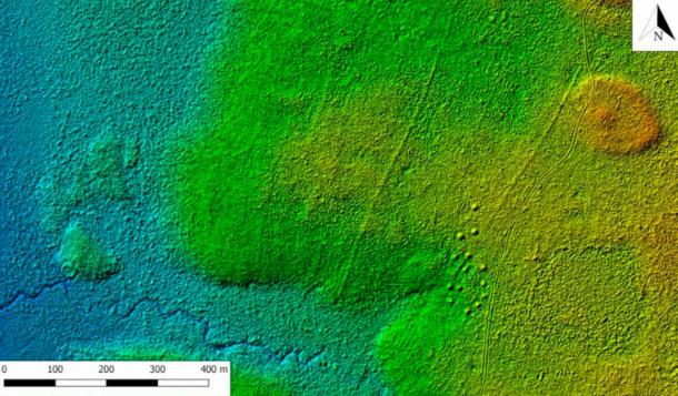

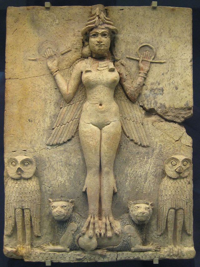

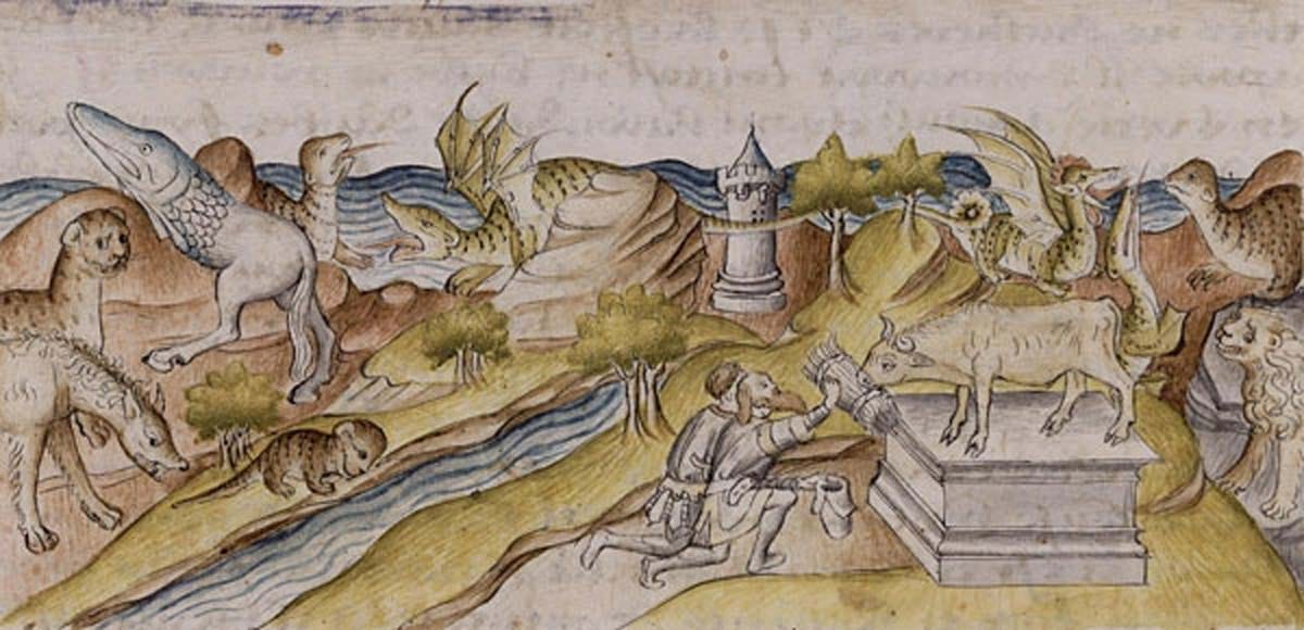


")


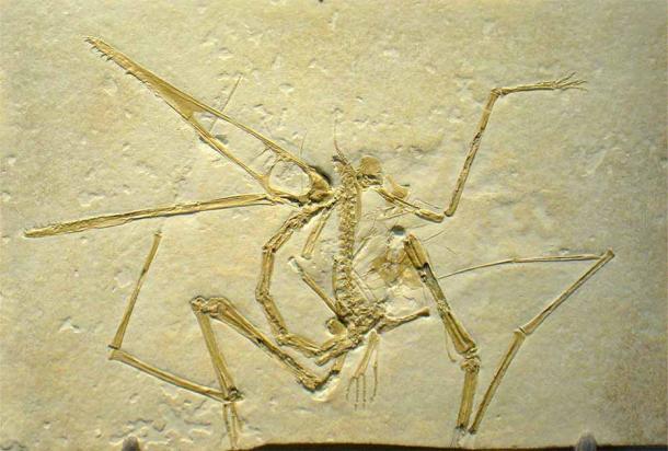

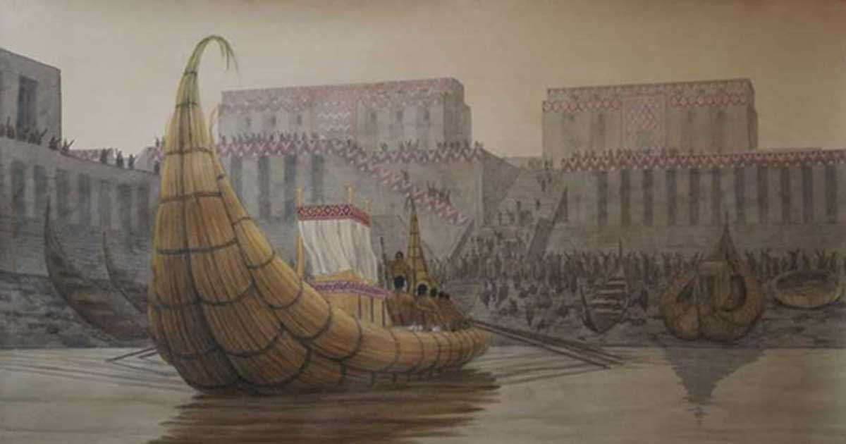
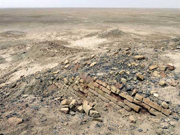
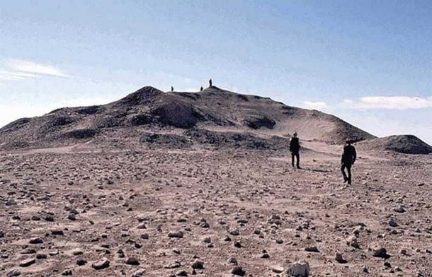
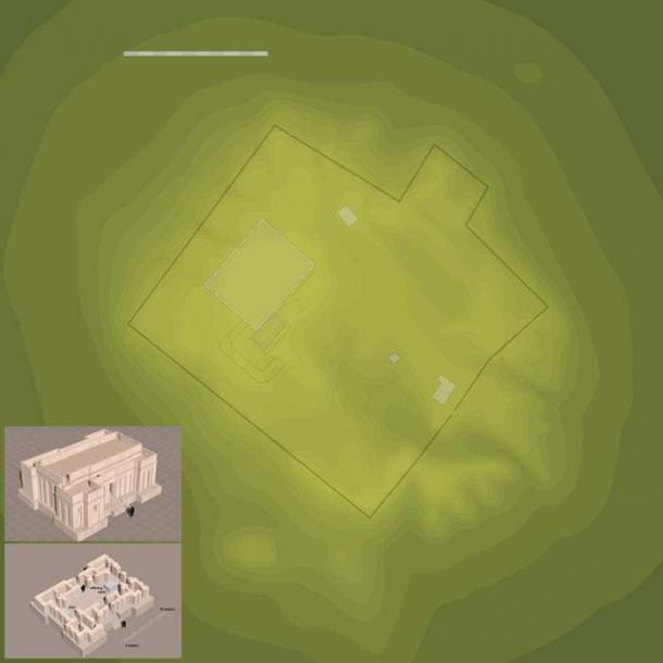
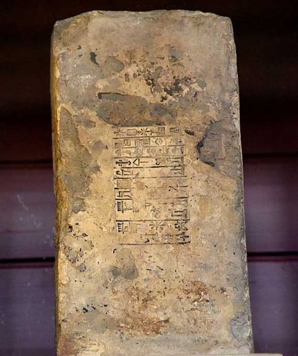

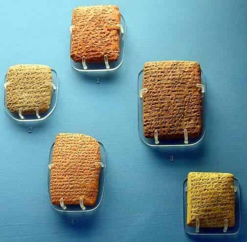
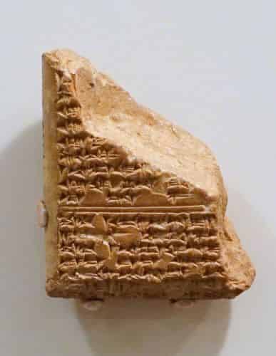
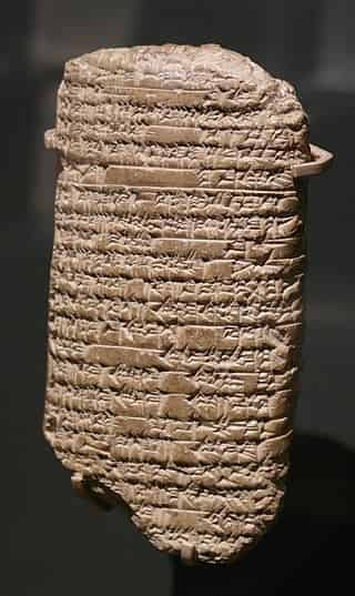

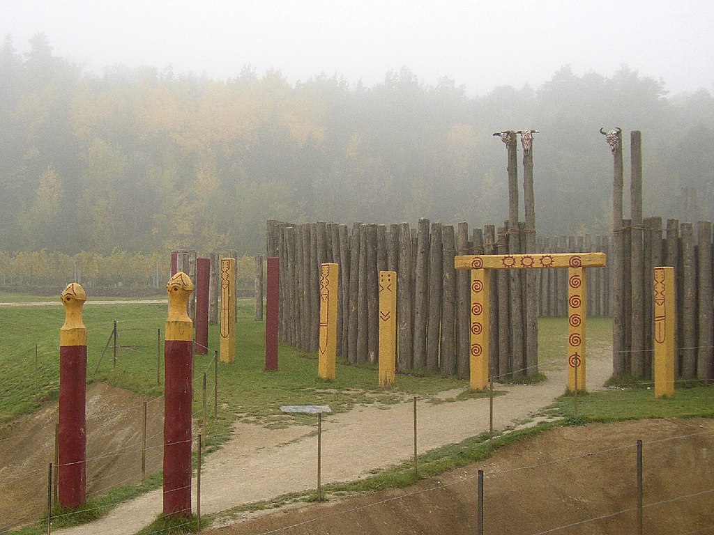
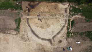

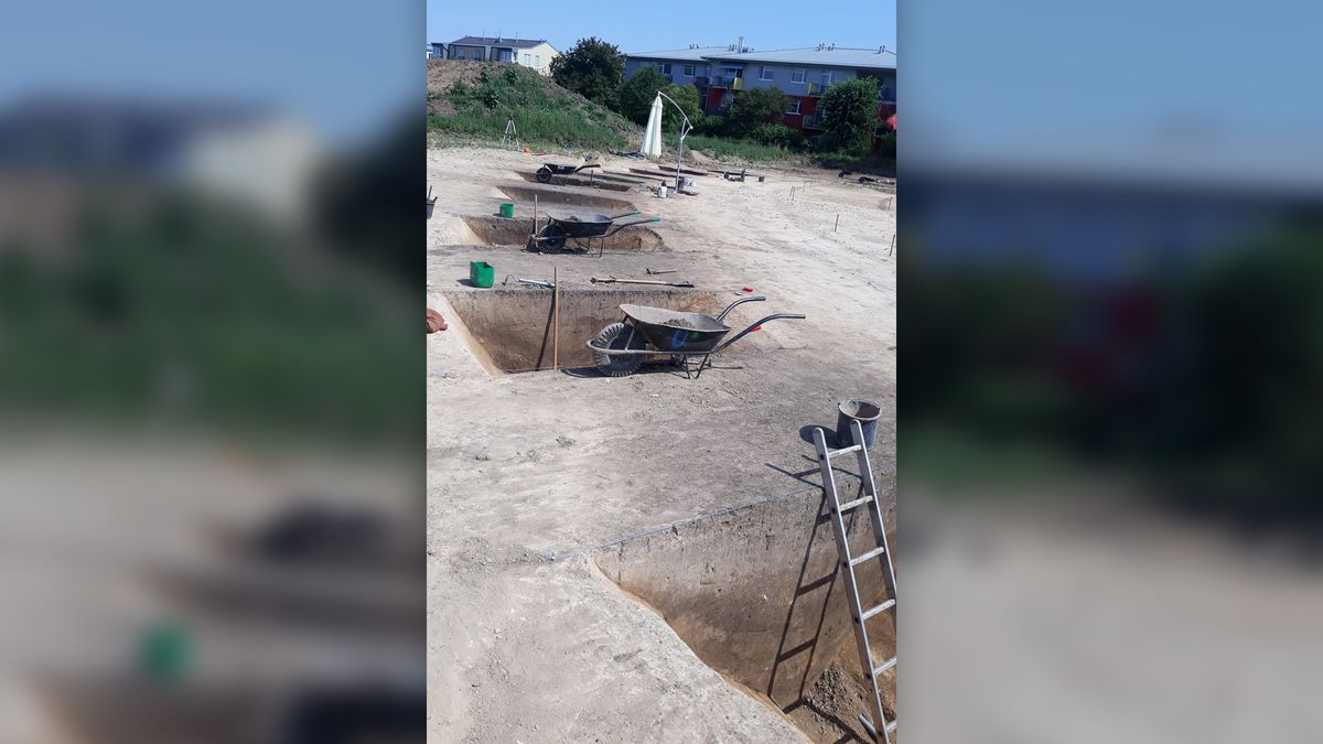
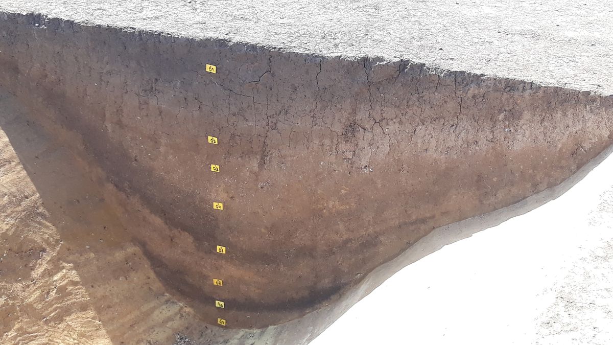
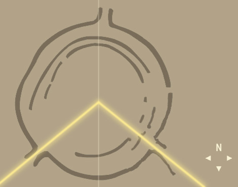

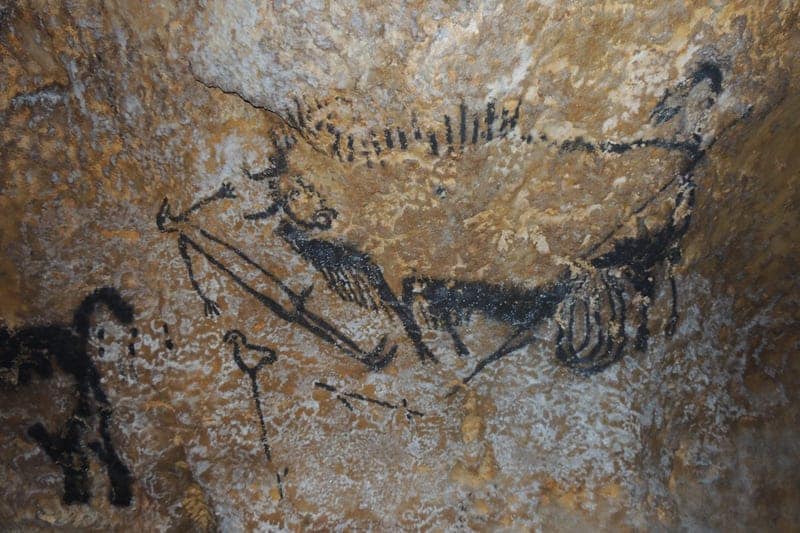
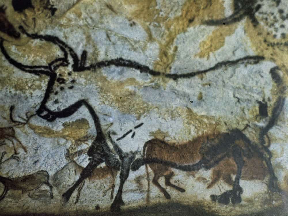
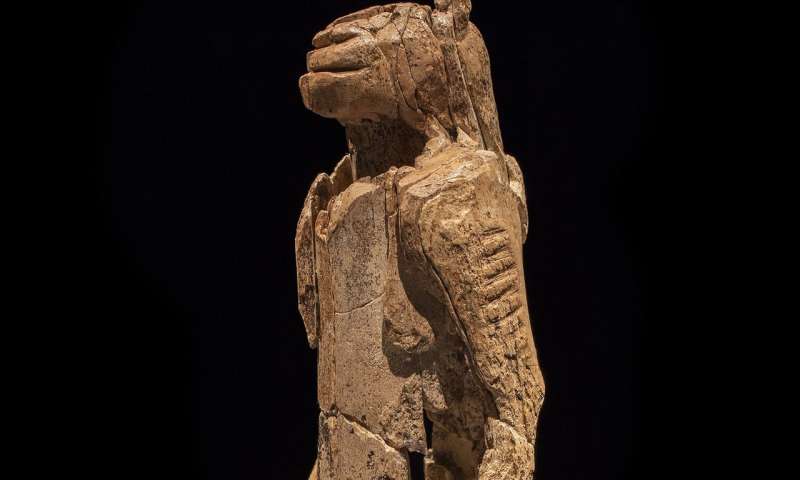


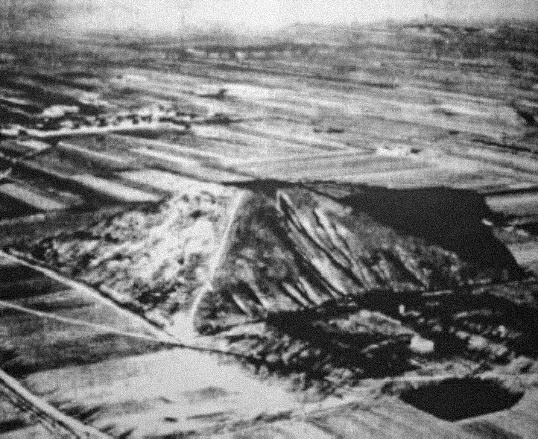

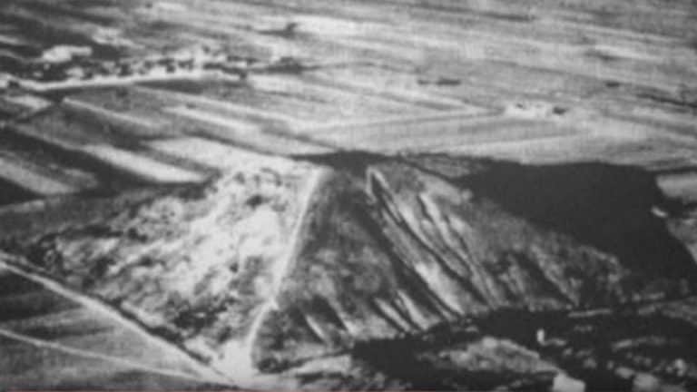

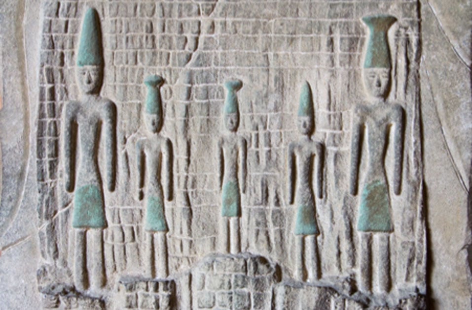
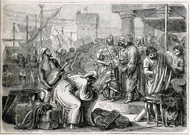
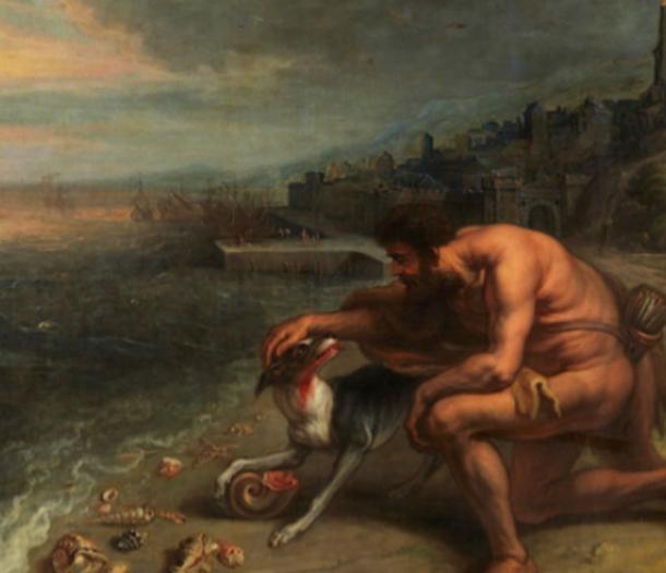

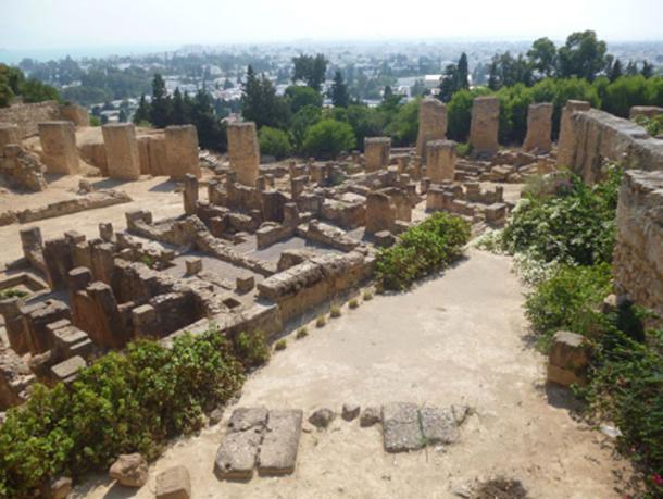
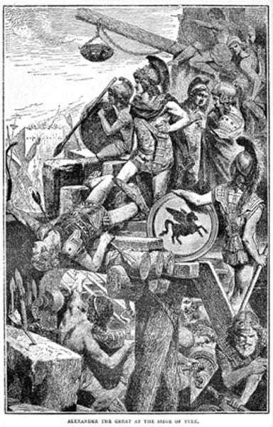
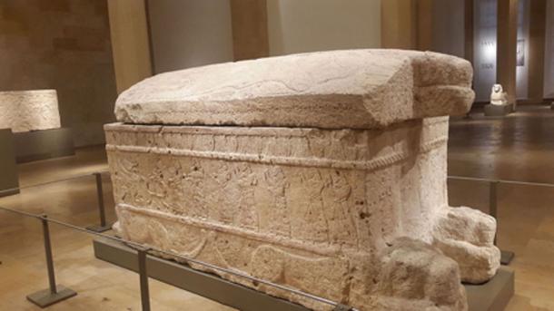


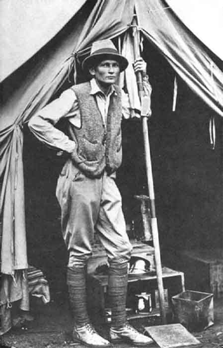
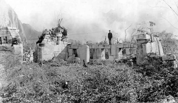


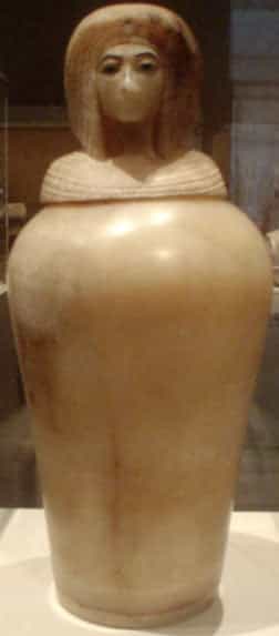
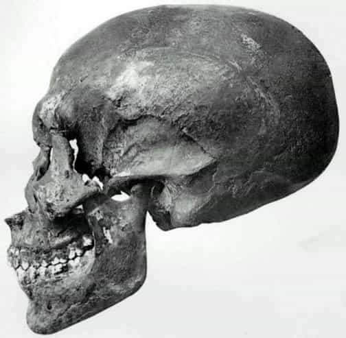
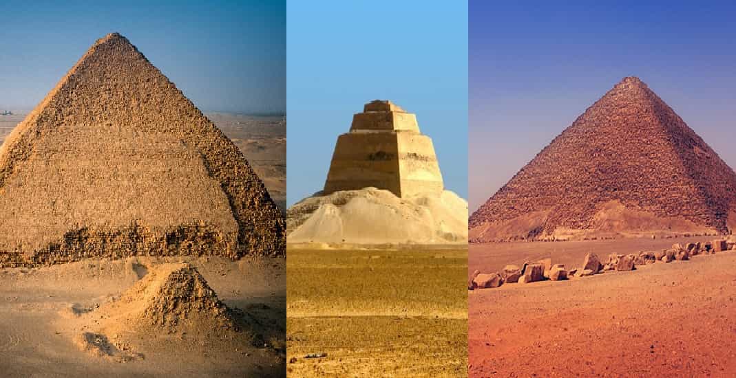
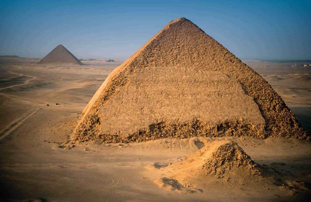
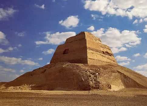
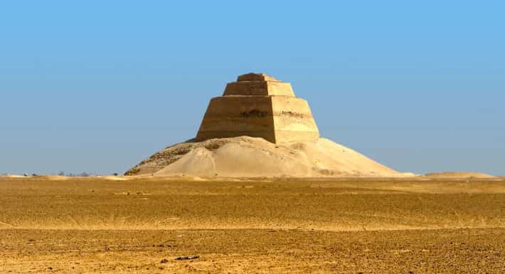
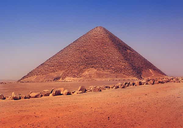
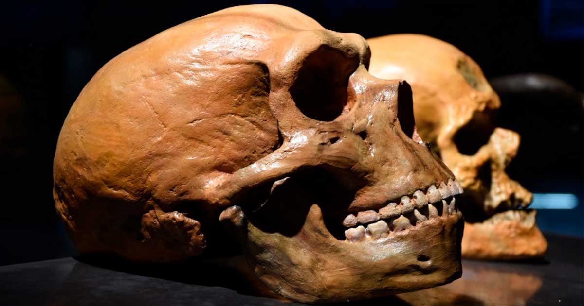


")


")


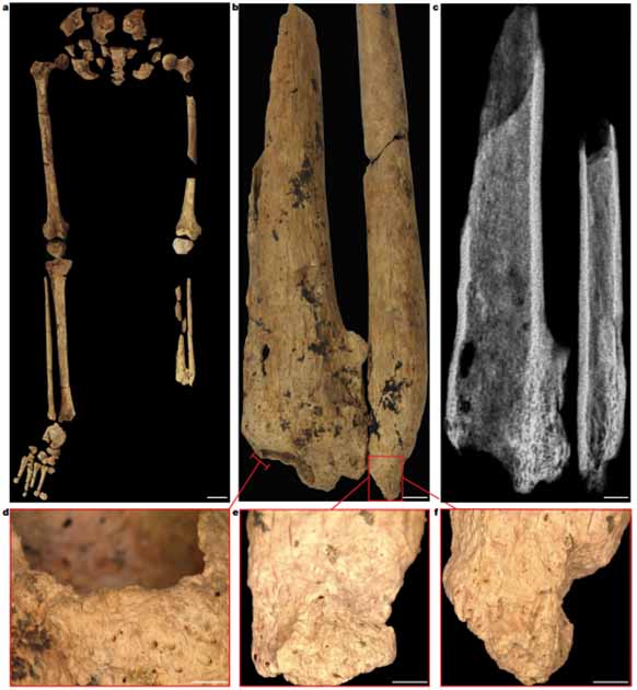
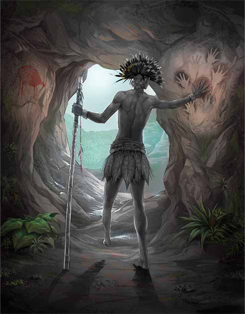


.jpg)
.jpg)
.jpg)