The purpose of this blog is the creation of an open, international, independent and free forum, where every UFO-researcher can publish the results of his/her research. The languagues, used for this blog, are Dutch, English and French.You can find the articles of a collegue by selecting his category. Each author stays resposable for the continue of his articles. As blogmaster I have the right to refuse an addition or an article, when it attacks other collegues or UFO-groupes.
Druk op onderstaande knop om te reageren in mijn forum
Zoeken in blog
Deze blog is opgedragen aan mijn overleden echtgenote Lucienne.
In 2012 verloor ze haar moedige strijd tegen kanker!
In 2011 startte ik deze blog, omdat ik niet mocht stoppen met mijn UFO-onderzoek.
BEDANKT!!!
Een interessant adres?
UFO'S of UAP'S, ASTRONOMIE, RUIMTEVAART, ARCHEOLOGIE, OUDHEIDKUNDE, SF-SNUFJES EN ANDERE ESOTERISCHE WETENSCHAPPEN - DE ALLERLAATSTE NIEUWTJES
UFO's of UAP'S in België en de rest van de wereld Ontdek de Fascinerende Wereld van UFO's en UAP's: Jouw Bron voor Onthullende Informatie!
Ben jij ook gefascineerd door het onbekende? Wil je meer weten over UFO's en UAP's, niet alleen in België, maar over de hele wereld? Dan ben je op de juiste plek!
België: Het Kloppend Hart van UFO-onderzoek
In België is BUFON (Belgisch UFO-Netwerk) dé autoriteit op het gebied van UFO-onderzoek. Voor betrouwbare en objectieve informatie over deze intrigerende fenomenen, bezoek je zeker onze Facebook-pagina en deze blog. Maar dat is nog niet alles! Ontdek ook het Belgisch UFO-meldpunt en Caelestia, twee organisaties die diepgaand onderzoek verrichten, al zijn ze soms kritisch of sceptisch.
Nederland: Een Schat aan Informatie
Voor onze Nederlandse buren is er de schitterende website www.ufowijzer.nl, beheerd door Paul Harmans. Deze site biedt een schat aan informatie en artikelen die je niet wilt missen!
Internationaal: MUFON - De Wereldwijde Autoriteit
Neem ook een kijkje bij MUFON (Mutual UFO Network Inc.), een gerenommeerde Amerikaanse UFO-vereniging met afdelingen in de VS en wereldwijd. MUFON is toegewijd aan de wetenschappelijke en analytische studie van het UFO-fenomeen, en hun maandelijkse tijdschrift, The MUFON UFO-Journal, is een must-read voor elke UFO-enthousiasteling. Bezoek hun website op www.mufon.com voor meer informatie.
Samenwerking en Toekomstvisie
Sinds 1 februari 2020 is Pieter niet alleen ex-president van BUFON, maar ook de voormalige nationale directeur van MUFON in Vlaanderen en Nederland. Dit creëert een sterke samenwerking met de Franse MUFON Reseau MUFON/EUROP, wat ons in staat stelt om nog meer waardevolle inzichten te delen.
Let op: Nepprofielen en Nieuwe Groeperingen
Pas op voor een nieuwe groepering die zich ook BUFON noemt, maar geen enkele connectie heeft met onze gevestigde organisatie. Hoewel zij de naam geregistreerd hebben, kunnen ze het rijke verleden en de expertise van onze groep niet evenaren. We wensen hen veel succes, maar we blijven de autoriteit in UFO-onderzoek!
Blijf Op De Hoogte!
Wil jij de laatste nieuwtjes over UFO's, ruimtevaart, archeologie, en meer? Volg ons dan en duik samen met ons in de fascinerende wereld van het onbekende! Sluit je aan bij de gemeenschap van nieuwsgierige geesten die net als jij verlangen naar antwoorden en avonturen in de sterren!
Heb je vragen of wil je meer weten? Aarzel dan niet om contact met ons op te nemen! Samen ontrafelen we het mysterie van de lucht en daarbuiten.
22-04-2018
THE ANCIENT EGYPTIAN TEXT THAT CONFIRMS ALIENS VISITED EARTH IN THE PAST
THE ANCIENT EGYPTIAN TEXT THAT CONFIRMS ALIENS VISITED EARTH IN THE PAST
It has been believed for quite some time now that the ‘Tulli Papyrus’ is probably the best evidence ever of ancient flying saucers in the distant past, but leading historians have questioned its authenticity and meaning and constantly dismiss it as evidence that Earth has been visited by Extra-terrestrials – But this factual piece of historic evidence should NOT be ignored.
Like many other ancient texts around the world, this ancient piece of evidence appears to tell an amazing story, one that could potentially change the way that we look at ourselves (past, present and the future), our history and the entire Universe!
It’s believed that this ancient piece of documentation, which in fact isn’t a papyrus actually, offers the earliest proof ever of flying saucers on planet earth – The Tulli “papyrus” is a translation of a modern transcription of an ancient Egyptian document.
The Pharaoh that ruled over Egypt was Thutmose III and according to this intriguing ancient text, this mass UFO sightings happened back in 1480 BC. At this time this incredible event was recorded in history as a day of significant importance – the day that something unexplainable and shocking occurred.
Please see below an actual translation into the above text pictured:
“In the year 22, of the third month of winter, sixth hour of the day […] among the scribes of the House of Life it was found that a strange Fiery Disk was coming in the sky. It had no head. The breath of its mouth emitted a foul odour. Its body was one rod in length and one rod in width. It had no voice. It came toward His Majesty’s house. Their heart became confused through it, and they fell upon their bellies. They [went] to the king, to report it. His Majesty [ordered that] the scrolls [located] in the House of Life be consulted. His Majesty meditated on all these events which were now going on.
After several days had passed, they became more numerous in the sky than ever. They shined in the sky more than the brightness of the sun, and extended to the limits of the four supports of heaven […] Powerful was the position of the Fiery Disks.
The army of the King looked on, with His Majesty in their midst. It was after the evening meal when the Disks ascended even higher in the sky to the south. Fish and other volatiles rained down from the sky: a marvel never before known since the foundation of the country. And His Majesty caused incense to be brought to appease the heart of Amun-Re, the god of the Two Lands. And it was [ordered] that the event [be recorded for] His Majesty in the Annals of the House of Life [to be remembered] for ever.”
This ancient old text was translated by many leading historians and scientists and is probably one of THE most important pieces of evidence of Ancient Aliens visiting earth – perhaps they have never actually left Earth?
This ancient old text was translated by many leading historians and scientists and is probably one of THE most important pieces of evidence of Ancient Aliens visiting earth – perhaps they have never actually left Earth?
This simply amazing historical event was described as being silent, but with incredible views of mysterious flying disks highly reflective, shining like the sun. According to this ancient text, the departure of the otherworldly visitors was marked by a mysterious event, as fish rained down from the heaven, almost as if some kind of unknown force affected the surroundings!
This ancient text clearly does not mention whether the ancient Egyptians did actually establish contact with these otherworldly Beings, but it is nonetheless an extremely important day in planet earths history – that is for both humanity and the ancient Egyptian Civilization at the time of this incredible event.
One VERY important thing to remember is that the Ancient Egyptians were extremely experienced and rather gifted astronomers, and it was by the year 1500 B.C, that they were already experts in this field, which means that they would not have mistaken these “fiery disks” with some kind of strange astronomical or weather phenomena – they would have described an astronomical phenomena in a completely different way. It is also rather important to remember that in these ancient documents, the “fiery disks” are described very clearly as they changed directions in the skies above the people who witnessed them, so it is very clear that we know that these objects didn’t fall, but remained in the Egyptian Sky ~this is not normal for an astronomical event (obviously).
In order to truly understand this ancient text this evidence would ideally need to be studies again in more detail. But isn’t it interesting that the original papyrus is gone!? But guess what people, top Researcher Samuel Rosenberg has already requested from the Vatican Museum an official opportunity to examine this mysterious/unknown important document, but the reply he received pretty much confirmed that ‘somebody’ does not want ANY interest shown in this key area and he had a response of:
”The Papyrus Tulli not property of Vatican Museum. Now it is dispersed and no more traceable.” Said the VATICAN museum.
It’s time to dig up the TRUTH from our past.
U.I.P SUMMARY – It appears that the Vatican are trying to hide away and archive this extremely piece of evidence, hidden on purpose away from the people of planet earth, perhaps hidden away in a secret archive, but why? Could it be that this piece of important evidence is that incredible and life changing that the elite and the heads of the Catholic church are SCARED about what this PROOF could cause amongst the masses.
This could be one of the most important pieces of evidence ever, and this could actually prove that the ET’s influenced the ancient Egyptian civilization as many Ancient Astronaut theorists believe? It is literally criminal that our so-called leaders are trying to hide this from us, however it is also very clear that the world leaders out there are playing games and trying to make us believe what THEY want us to believe!
THIS is such an important story and one that we can never ignore. SOME stupid world leaders LAUGH when the subject matter of ‘Aliens’ is raised – soon they will NOT be laughing, when the control starts slipping away from their hands and the TRUTH starts spilling out!
The Pyramids are so important to all of our history, you can feel this just by looking at them and seeing the sheer amount of energy coming from them!
The pyramids are to this day still a mystery, but a mystery that is soon about to be dragged out kicking and screaming!
The Megalithic Stones Of Carnac—An Ancient Cosmic Map?
The Megalithic Stones Of Carnac—An Ancient Cosmic Map?
The megalithic stones of Carnac are a set of stones intricately positioned in Brittany. It is the most extensive prehistoric monument in the world. This megalithic site is believed to have been erected during the Neolithic, probably around 3300 BCE, but some may date to as early as 4500 BCE.
Like extensive lines of penitents, the enigmatic stones of Carnac were positioned in a straight line across the rough territory of Brittany, keeping guard in front of the waters of the Bay of Biscay
Local tradition has yielded a number of interesting legends about the menhirs.
Although their presence and configuration are truly mysterious, the peasants of the region found a way to explain them. According to a deep-rooted belief, the megaliths are Roman soldiers petrified by God to protect Saint Cornelius, patron of Carnac.
Another one suggests that, at night, the stones come to life and advance towards the sea to bathe or to drink.
The famous neolithic menhirs near Carnac, Brittany, France.
They have been credited with healing powers, and it was believed that they could provide fertility and help people who seek love.
The Stones of Carnac are not only one of the most extensive prehistoric monument in the world, they were seeming just as important when they were erected, and evidence of that is the number of stones that were present in the area.
According to experts, when the stones were erected, there were as many as 10 thousand.
Today, after thousands of years, only 3,000 remain, in four large groupings: Le Menéc, Kermario, Kerlescan and LePetitMenéc.
Next to the village of Le Menéc is where the most numerous alignment begins.
There are 1,099 stones in eleven rows placed mimicking soldiers or schoolchildren, in order of height: the largest measure 3.7 meters and the smallest only 90 centimeters.
They were positioned facing northeast in gentle undulations along a slightly curved line.
The Kermario megaliths are larger, with megaliths exceeding 7 meters in height and decrease in size over an area of 1,200 kilometers.
The other two groupings are smaller, but Kerlescan differs by a square configuration of the 540 stones that compose it.
Jerome Penhouet proposed, in 1826, that the four alignments of Carnac were part of the body of a massive snake that was depicted on the lands of Brittany.
However, different eras produced different theories trying to explain the mystery behind the stones.
During the nineteenth century, it was suggested that these were places dedicated to the solar and lunar cult, while other authors thought that they were avenues that led to the temples that have now disappeared from sight.
Atlantean remains?
Hans Hirmenech suggested that the rows of menhirs were the tombs of Atlantean soldiers who had died during the Trojan War.
Also, James Fergusson proposed that the erection of these monuments should commemorate a sort of great battle that took place in ancient times.
Other scholars who studied the megalithic stones went further and proposed that they were true tombs and believed they found support for this reasoning in the meaning of the names of some places: in Breton, a language of Celtic origin, Kermario means “city of the dead”.
However, when formulating the last theory, it seems that exerts ignored the fact that the menhirs are much older than the appearance of the Celts in this region.
Cosmic map?
The first to allude to the “celestial map theory” of Carnac was André Cambry, who maintained that the stones of Carnac mimick the stars, the planets, and the zodiac.
After Chambry, other authors took up the idea and, in 1970, the English engineer Alexander Thom followed the footsteps of Gerald Hawkins in his studies on Stonehenge and applied them to Carnac.
According to Thom, the great fallen menhir of Locmariaquer was the center of an immense astronomical observatory capable of predicting eclipses.
Their measurements indicate that from this supermassive gigantic menhir it was possible to observe the eight extreme positions of the Moon.
He also proposed that the Carnacalignment were solar calculators, used to correct the irregularities observed in the movements of the Moon.
The immense fallen menhir of Locmariaquer, known as Er Grah (the Stone of the Fairies), measured more than 20 meters in height and is believed to have existed with a combination of other menhirs that are now gone. This massive menhir has an estimated weight of 280 tons.
It remains a profound mystery as to how ancient people managed to move this, and other menhirs to their current positions, without the use of advanced technology.
A Mystery In History: When God Made Burning Sulfur Destroy Sodom And Gomorrah
A Mystery In History: When God Made Burning Sulfur Destroy Sodom And Gomorrah
“Then the Lord rained down burning sulfur on Sodom and Gomorrah—from the Lord out of the heavens. Thus he overthrew those cities and the entire plain, destroying all those living in the cities—and also the vegetation in the land…” (Source)
Sodom and Gomorrah were two ancient cities that, according to the Old Testament, were destroyed in ancient times by supernatural means.
The cities are described as two of the cities that were part of the biblical Pentapolis, located on the shores of the Dead Sea. Gomorrah was situated in the valley of Siddim next to the Dead Sea and was one of the five cities of the plain, along with Sodom, Adma, Zoar, and Zeboim.
The story of Sodom and Gomorrah takes place primarily in Genesis 19, where it is reported that God sentenced the destruction to these cities by the abject perversion of its inhabitants.
YHWH rained on Sodom, and Gomorrah brimstone and fire destroyed these cities and all the men in them.
“(Gn 19: 27-28) God decides to take the life he gave them, but before executing his sentence sends two angels to the city of Sodom with the mission of rescuing Lot and his people.
In this part of the scriptures, Gomorrah is not mentioned as part of the visits of the angels or that Lot had any connection with this neighboring city of Sodom.
The destruction of Sodom and Gomorrah, John Martin, 1832.
Moses referred to the destruction of Sodom and Gomorrah in Deuteronomy 29:22–23:
“Your children who follow you in later generations and foreigners who come from distant lands will see the calamities that have fallen on the land and the diseases with which the Lord has afflicted it. The whole land will be a burning waste of salt and sulfur—nothing planted, nothing sprouting, no vegetation growing on it. It will be like the destruction of Sodom and Gomorrah, Admah and Zeboyim, which the Lord overthrew in fierce anger.” —NIV
A wealth of information is available about the cities of Sodom and Gomorrah in various religious texts, including the Koran, where we find details of accounts that are a mixture of facts and myths.
The legends of Sodom and Gomorrah speak of peculiar personalities, angels and other deities who literally warned people to leave these doomed cities whose catastrophic fate was inevitable. These stories are a mixture of different accounts.
Many Biblical scholars would agree that Sodom and Gomorrah are probably two of the most infamous cities that may have existed on planet Earth.
These cities have been lost for millennia, and only in recent years, have the sites been tentatively identified by experts who have proposed dozens of different theories about these mystical cities and their fate.
But what really happened here and what do the stories tell? What has been written down?
Here are some of the things we have to know when talking about Sodom and Gomorrah
The Bible tells the story of what happened:
(Genesis 18:20; 19: 24-26.28)
24 Then the Lord rained down burning sulfur on Sodom and Gomorrah—from the Lord out of the heavens. 25 Thus he overthrew those cities and the entire plain, destroying all those living in the cities—and also the vegetation in the land. 26 But Lot’s wife looked back, and she became a pillar of salt.
27 Early the next morning Abraham got up and returned to the place where he had stood before the Lord. 28 He looked down toward Sodom and Gomorrah, toward all the land of the plain, and he saw dense smoke rising from the land, like smoke from a furnace.
Sodom and Gomorrah being destroyed in the background of Lucas van Leyden’s 1520 painting Lot and his Daughters.
Their Geographical location remains disrupted. However, some experts believe that the ancient cities of Sodom and Gomorrah are Bab edh-Dhra and Numeira, two adjacent archeological sites said by some to be the two cities’ locations.
Bab edh-Dhra is the site of an Early Bronze Age settlement located near the Dead Sea, on the south bank of Wadi Kerak. Some biblical scholars argue that this was the ancient city of “Sodom”. Other archaeologists disagree.
The archaeological site of Numeira is, according to some scholars, the location of the city of Gomorra.
It has been argued that Numeira approximates the alleged biblical city of Gomorrah, although other several scholars have countered these claims, arguing that it is in the wrong geographical area, and is not within the designated timeframe.
And while the location of these two important historic cities remains a mystery for experts, ancient astronaut theorists suggest that Sodom and Gomorrah are the Hiroshima and Nagasaki of the distant past, 4000 years ago.
Some ancient astronaut theorists believe that these ancient accounts, described in the Bible and other religious texts indicate the presence of supernatural beings present on Earth, and how these two cities were destroyed, not by God’s wrath, but by the use of extremely advanced weaponry, brought to Earth by beings, not from Earth.
The Area where Sodom And Gomorra were allegedly located is also particularly interesting.
The Dead Sea’s surface and shores are 429 meters (1,407 ft) below sea level, representing Earth’s lowest elevation on land.
The Dead Sea is 304 m (997 ft) deep, which makes it the deepest hypersaline lake in the world.
With 34.2% salinity, The Dead Sea also happens to be one of the world’s saltiest bodies of water, though Lake Vanda in Antarctica (35%), Lake Assal in Djibouti (34.8%) in Jordan and many smaller rivers flow into the Dead Sea.
The Jordan river has a major importance in Judaism and Christianity and, to a more moderate degree, Islam. It is said to be the site where the Israelites crossed into the Promised Land and where John the Baptist baptized Jesus of Nazareth.
Interestingly, according to scientific measurements, evaporation under the burning sun occurs on the surface of the Dead Sea at a speed of more than 230 million cubic feet per day.
As noted by Arab tradition, there are many poisonous gases evaporating from the lake that are so hazardous that birds cannot fly over it.
Inexplicable Similarities Between Göbekli Tepe, Easter Island, And Other Ancient Sites
Inexplicable Similarities Between Göbekli Tepe, Easter Island, And Other Ancient Sites
Design elements present at Göbekli Tepe are also found in Easter Island on the massive Moai Statues, in Tiahuanaco, and other ancient sites around the globe. How’s this possible?
Despite the fact that we’ve studied our ancestors, their cultures, their origin, and their way of life, we have failed to answer many questions related to our past.
The countless monuments scattered across the globe are an ancient message left behind by our ancestors, a message which despite extensive studies, we have yet failed to decipher.
One of the most mysterious ancient temples on Earth is located in modern-day Turkey, more precisely, the city of Urfa.
There, we find an ancient temple complex which is believed to have been erected around 9,600 BC.
Image Credit: Shutterstock
Göbekli Tepe is considered among many experts as the oldest temple on Earth, and despite its importance, we know very little about it.
Not only is this ancient temple complex important because of its age, but it’s also of great importance because by who it was built, and perhaps, even more interestingly, by the symbology it offers.
If you take a close look at Göbekli Tepe, you will notice a curious stance and symbolism that we can find in many other places across the globe.
On Easter Island, for example, we see a great similarity between the Moai and the curious Pillars at Göbekli Tepe.
On both archaeological sites, it seems the ancient builders used the same symbology.
Notice the curious position of the hands.
Image Credit: National Geographic.
But is this a mere coincidence?
The Archaeological site of Göbekli Tepe is composed of several temples whose main construction motif are massive stone pillars that range in weight between 30 and 60 tons.
Somehow, thousands of years ago, ‘primitive’ cultures managed to quarry, transport and build something history tells us should not exist.
These enigmatic T-shaped pillars are intricately decorated with depictions of a number of animals such as foxes, lions, snakes, etc.
However, in addition to the various animal depictions at Göbekli Tepe, we see humanoid characteristics depicted on some of the pillars.
Göbekli Tepe’s T-shaped stela display arms and hands belonging to what many experts believe are depictions of humanoid beings.
The ancient builders of Göbekli Tepe carved on the t-shaped tocks long hands and arms of what could also be representations of their gods.
However, this extremely interesting symbolism is not unique to Göbekli Tepe and is found in various archeological sites across the globe.
If we travel halfway around the globe to Easter Island, in the middle of the Pacific Ocean, we see the massive Moai statues and their curious symbolism which is eerily similar to the stone pillars of Göbekli Tepe.
A Statue from Tiahuanaco, Bolivia. Notice the hand posture.
The massive Moai were intricately carved in a sacred standing position, with hands position on omphalos.
Many authors agree that this posture is meant to portray birth or rebirth.
But how is it possible that such symbolism is present both in Göbekli Tepe and on Easter Island? Is this just a coincidence?
Not likely, as other ancient sites around the globe feature the same thing.
If we take a trip back to Turkey, we will find that the Neolithic settlement of Nevali Cori and Kilisik feature similar design elements.
But that’s not it.
Statues from Tiahuanaco in Bolivia, and archaeological sites in Mexico, as well as Mesopotamia, feature the very same symbolism: massive stone statues and hands coming together.
The question is… what connects all of these archaeological sites, and, is it possible that somehow, these ancient cultures shared a common designer?
Ley Lines, Ancient Flight Plans, And Their Mind-Bending Connection To Ancient Monuments
Ley Lines, Ancient Flight Plans, And Their Mind-Bending Connection To Ancient Monuments
Have you ever heard about the so-called Ancient flight plans?
Mostly found in Britain and France, ancient flight plans are geographical markers placed intentionally, that are interconnected and clearly visible once portrayed on a map.
If we travel to Herefordshire England, we find what AncientAstronauttheorists call ‘AncientFlightPlans‘.
Said to have been discovered by amateur archaeologist AlfredWatkins while horseback riding, Watkins is believed to have noticed that structures across the landscape appeared to be arranged in straight, continuous lines.
Four years after that, in 1925 Watkins published his book “The old straight tracks” where he theorized that ancient mankind built monuments and megaliths across the Earth and that these were connected by a network of straightlines: Referred to as Ley lines.
In his book, “The old straight tracks“, Watkins proposed that ancient monuments were deliberately placed along these ‘tracks’ for a line of sight navigation and may have even been used as trade routes.
However, there’s a slight issue with that theory.
Some of the so-called straight tracks cross terrains that were difficult to access and to identify.
The following natural and man-made features were suggested by Watkins to be reliable ley-markers:
Mounds, Long-barrows, Cairns, Cursus, Dolmens, Standing stones, mark-stones, Stone circles, Henges, Water-markers (moats, ponds, springs, fords, wells), Castle, Beacon-hills, Churches, Cross-roads, Notches in hills, Camps (Hill-forts),
This leads us to believe there must be a different explanation for their purpose.
Most of these so-called ley lines are found in England and in France, although they are not limited to these two countries.
They are basically geographic markings of a number of places of historical interest, such as ancient monuments and megaliths, natural ridge-tops and similar places.
According to Linda Moulton Howe, an American investigative journalist and Regional Emmy award-winning documentary filmmaker best known for her work as a ufologist and advocate of a variety of conspiracy theories: “The Michael Line in England is a straight line and it is measurable. It’s a magnetic field line that you can measure and it will be higher than other areas around it geographically. “
Today there are many authors and researchers who believe that these so-called Ley lines, are in fact, magnetic in nature and that they delineate the lines of Earth’s unseen energy fields.
Remember my article on the Earth Grid?
If we travel to Denmark, we will find more of these geometrical patterns, along with the northern reaches of the European continent. In Scandinavia, we find the archaeological ruins of a once prospering and mighty Viking fortress dating to 900 A.D.
Preben Hansson first discovered a direct line of flight fromTrelleborg to other three Viking fortresses, which happen to be very similar in design.
But not only are these structures similar in design, but a direct line connects these four Viking Forts in Denmark.
A bit strange, don’t you think?
But there’s something more that doesn’t seem to add to the story.
Ley lines - Europe
As we all know, the Vikings were seafaring people, well-known as mighty warriors and sailors. Because they were seafaring people, it makes sense that most of their settlements and forts were near water.
However, here we have forts positioned inland, which also happen to be precisely aligned.
Furthermore, a more detailed analysis of the forts revealed a fascinating detail. Not only are these forts precisely aligned, but researchers have been left stunned by the precisedesign of Trelleborg, with courtyard’s divided into four zones, each with four longhouses and gateways open precisely to the four cardinaldirections: north, south, east, and west.
That makes it clear that the construction and design of Trelleborg would have required great knowledge of engineering, orientation, and positioning.
Are Ley Lines a global phenomenon?
Several authors and ancient astronaut theorists note that if you draw a straight line and cross the Alps in Europe, you will eventually reach Delphi in Greece.
Why is this important? Delphi is known as the homeplace of the Oracle of Delphi and to the God Apollo.
According to Greek mythology, the mighty God Apollo took his “heavenly chariot” and disappeared heading north.
This idea has aroused the interest of various ancient astronaut theorists who see a clear connection between the so-called ley lines, and other historically important geographic locations on Earth.
Is it possible that these patterns, lines, and ancient structures are all interconnected as some theorists suggest?
Why is it that there are so many ancient structures around the globe that appear to follow an intricate pattern? Lines, geometric shapes?
It is not a coincidence, say ancient astronaut theorists, pointing to other incredibly positioned structures such as the Pyramids of Giza, or even the Nazca lines in Peru, which just as some of the ley lines in England seem to bare magnetic anomalies.
The perfect alignment of these locations to the stars, the cosmos, and to other monuments around the world is something that was not done randomly.
The Ley lines, the Earth Grid, and the electromagnetic field anomalies that are present in different geographic locations around the world does not seem something random.
It is something planned, something elaborate, something that truly seems, out of this world.
“If an industrial civilization had existed on Earth many millions of years prior to our own era, what traces would it have left and would they be detectable today?”
That’s the opening question asked by Gavin A. Schmidt and Adam Frank in their new research paper, “The Silurian Hypothesis: Would it be possible to detect an industrial civilization in the geological record?”, in which they look for geological fingerprints of advanced civilizations that may have lived on Earth before our own and been wiped out by some sort of extinction cataclysm. Did they find it?
Adam Frank, professor of physics and astronomy at the University of Rochester, describes the jaw-dropping research proposal presented to him by Gavin Schmidt, the director of the NASA Goddard Institute for Space Studies, in an excellent article in the current edition of The Atlantic. It follows the publication of the study (also an excellent read) in the International Journal of Astrobiology.
(“Ma” = a million years ago; “Ga” = a billion years ago)
“Humans are the only example [of an industrial civilization] we know of, and our industrial civilization has lasted (so far) roughly 300 years (since, for example, the beginning of mass production methods). This is a small fraction of the time we have existed as a species, and a tiny fraction of the time that complex life has existed on the Earth’s land surface.”
However, it’s big enough to have a physical impact on the surface of the Earth – an impact that would be evident to future researchers digging thought the layers of the planet’s crust millenniums from now. Frank and Schmidt start here, because that industrial civilization evidence may be the same thing we need to be looking for to find past civilizations.
But first … the name.
“We name the hypothesis after a 1970 episode of the British science fiction TV series Doctor Who where a long-buried race of intelligent reptiles “Silurians” are awakened by an experimental nuclear reactor. We are not however suggesting that intelligent reptiles actually existed in the Silurian age, nor that experimental nuclear physics is liable to wake them from hibernation.”
Of course, you Doctor Who fans already knew this. A name you may not recognize is “Anthropocene,” which is the moniker proposed for our current geological period. What would identify the Anthropocene age to future geologists? The study points to evidence of fossil fuel usage, plastics (our garbage), agriculture (fertilizers and erosion), pollutants, unusual radioactive isotopes (from nuclear war or meltdowns) and climate change (variations in carbon dioxide, methane, etc.). While these are indicators of the existence of an industrial civilization, they may also be indicators of what killed it.
Then again, what if the advanced civilization was more advanced than we Anthropocene beings. If they no longer used fossil fuels, would we find dead batteries instead? There’s also the question of how long the civilization was industrial. We’ve only been there for 300 years. Even if it lasted 100,000 years, after millions of years, would there be any evidence left? How thin would that layer be?
Is this our layer?
As you may have guessed, Frank and Schmidt didn’t find evidence of a past advanced civilization yet … nor did they find the Silurians (which may be good news because they’d probably want royalties (or something more painful) for the use of their name). However, they point out that looking for evidence of past industrial civilizations on Earth provides knowledge that will help determine if other planets had similar now-extinct advanced life forms. They also warn that, while they have found clear evidence of other periods of global warming/climate change that match what we’re going through (the Paleocene-Eocene Thermal Maximum 56 million years ago, for example), that period did not match “the speed at which we’re dumping fossil carbon into the atmosphere … never before in the planet’s multibillion-year history has so much buried carbon been dumped back into the atmosphere so quickly.”
Will the only evidence of the Anthropocene age be a thin black residue in the Earth’s crust? Maybe we should stop looking for past civilizations and start looking in the mirror.
The more we learn about ancient humans, the less we seem to know. Recent archaeological discoveries of ancient civilizationshave upended our theoretical timelines of human evolution, and we’ve found the other known species of humans, Neanderthals and Denisovans, had a much larger role in our genetic story than previously thought. According to a paper published in PLOS ONEby a team of Australian archaeologists, now another mysterious culture has been discovered. The archaeologists say that tools and animal hides discovered in a cave in Indonesia belonged to a primitive, ancient culture, and might be evidence of a “distinct human species” that called the area home some 50,000 years ago.
The cave, called Leang Burung, sits on the island of Sulawesi in southern Indonesia. It was discovered and first excavated in 1975, and the artifacts found were seen as evidence modern humans’ arrival to the area between 25,000 and 34,000 years ago. The new findings suggest something different. Dr. Adam Brumm of Griffith University’s Australian Research Centre for Human Evolution specifies:
We have uncovered archaeological evidence for an ancient population of “Ice Age” hunter-gatherers that inhabited Leang Burung 2 rock-shelter around 50,000 years ago.
Dr. Brumm says that early modern humans were creating cave art in nearby sites by 40,000 years ago, which suggests that the newly discovered ancient culture arrived on Sulawesi before the Ice-Age cave painting culture did. The inhabitants of Leang Burung were much more primitive than the known early humans of the time. Based on this, Brumm says, “the first inhabitants of this site may not only have been members of a different culture but also a distinct human species.”
Artist’s depiction of a Neanderthal tribe, who were a different species of human.
What that species may be is unclear. Sulawesi was one of the last stops before Australia on the road of human migration, and there were many different species and subspecies of hominins that journeyed across the chain of islands over the course of millennia. The island sits to the north of Flores, where the ancient race of “hobbits” were discovered, and recent research suggests that the mysterious Denisovan hominins made their way to Australia, where they bred with early humans, via the same route.
Map showing the timeline of human migration out of Africa
The archaeologists have not yet reached the bottom layers of sediment and they say that with further excavation they may find evidence of even older civilizations.
The researchers are quick to say that, while they believe that this is evidence of a separate human species, it may be that these artifacts belonged to the same Ice-Age cave artists that were previously discovered in the area, or it could be another group of early humans. Adam Brumm says:
It is now known that Homo Sapiens evolved in Africa at least 300,000 years ago and that an early population of our species had spread out of Africa (into Israel) by 200,000 years ago, and possibly even made it much further east.
Whatever culture it was, it’s another look into the fascinating and mysterious path our ancestors and ancient relatives took, and yet another example of how limited our knowledge of the past really is.
It only took five minutes for Gavin Schmidt to out-speculate me.
Schmidt is the director of nasa’s Goddard Institute for Space Studies (a.k.a. GISS) a world-class climate-science facility. One day last year, I came to GISS with a far-out proposal. In my work as an astrophysicist, I’d begun researching global warming from an “astrobiological perspective.” That meant asking whether any industrial civilization that rises on any planet will, through their own activity, trigger their own version of a climate shift. I was visiting GISS that day hoping to gain some climate science insights and, perhaps, collaborators. That’s how I ended up in Gavin’s office.
Just as I was revving up my pitch, Gavin stopped me in my tracks.
“Wait a second,” he said. “How do you know we’re the only time there’s been a civilization on our own planet?”
It took me a few seconds to pick my jaw off the floor. I had certainly come into Gavin’s office prepared for eye rolls at the mention of “exo-civilizations.” But the civilizations he was asking about would have existed many millions of years ago. Sitting there, seeing Earth’s vast evolutionary past telescope before my mind’s eye, I felt a kind of temporal vertigo. “Yeah,” I stammered, “Could we tell if there’d been an industrial civilization that deep in time?”
We never got back to aliens. Instead, that first conversation launched a new study we’ve recently published in the International Journal of Astrobiology. Though neither of us could see it at that moment, Gavin’s penetrating question opened a window not just onto Earth’s past, but also onto our own future.
We’re used to imagining extinct civilizations in terms of the sunken statues and subterranean ruins. These kinds of artifacts of previous societies are fine if you’re only interested in timescales of a few thousands of years. But once you roll the clock back to tens of millions or hundreds of millions of years, things get more complicated.
When it comes to direct evidence of an industrial civilization—things like cities, factories, and roads—the geologic record doesn’t go back past what’s called the Quaternary period 2.6 million years ago. For example, the oldest large-scale stretch of ancient surface lies in the Negev Desert. It’s “just” 1.8 million years old—older surfaces are mostly visible in cross section via something like a cliff face or rock cuts. Go back much farther than the Quaternary and everything has been turned over and crushed to dust.
And, if we’re going back this far, we’re not talking about human civilizations anymore. Homo sapiens didn’t make their appearance on the planet until just 300,000 years or so ago. That means the question shifts to other species, which is why Gavin called the idea the Silurian hypothesis, after an old Dr. Who episode with intelligent reptiles.
So, could researchers find clear evidence that an ancient species built a relatively short-lived industrial civilization long before our own? Perhaps, for example, some early mammal rose briefly to civilization building during the Paleocene epoch about 60 million years ago. There are fossils, of course. But the fraction of life that gets fossilized is always minuscule and varies a lot depending on time and habitat. It would be easy, therefore, to miss an industrial civilization that only lasted 100,000 years—which would be 500 times longer than our industrial civilization has made it so far.
Given that all direct evidence would be long gone after many millions of years, what kinds of evidence might then still exist? The best way to answer this question is to figure out what evidence we’d leave behind if human civilization collapsed at its current stage of development.
Now that our industrial civilization has truly gone global, humanity’s collective activity is laying down a variety of traces that will be detectable by scientists 100 million years in the future. The extensive use of fertilizer, for example, keeps 7 billion people fed, but it also means we’re redirecting the planet’s flows of nitrogen into food production. Future researchers should see this in characteristics of nitrogen showing up in sediments from our era. Likewise our relentless hunger for the rare-Earth elements used in electronic gizmos. Far more of these atoms are now wandering around the planet’s surface because of us than would otherwise be the case. They might also show up in future sediments, too. Even our creation, and use, of synthetic steroids has now become so pervasive that it too may be detectable in geologic strata 10 million years from now.
And then there’s all that plastic. Studies have shown increasing amounts of plastic “marine litter” are being deposited on the seafloor everywhere from coastal areas to deep basins and even in the Arctic. Wind, sun, and waves grind down large-scale plastic artifacts, leaving the seas full of microscopic plastic particles that will eventually rain down on the ocean floor, creating a layer that could persist for geological timescales.
The big question is how long any of these traces of our civilization will last. In our study, we found each had the possibility of making it into future sediments. Ironically, however, the most promising marker of humanity’s presence as an advanced civilization is a by-product of one activity that may threaten it most.
When we burn fossil fuels, we’re releasing carbon back into the atmosphere that was once part of living tissues. This ancient carbon is depleted in one of that element’s three naturally occurring varieties, or isotopes. The more fossil fuels we burn, the more the balance of these carbon isotopes shifts. Atmospheric scientists call this shift the Suess effect, and the change in isotopic ratios of carbon due to fossil-fuel use is easy to see over the last century. Increases in temperature also leave isotopic signals. These shifts should be apparent to any future scientist who chemically analyzes exposed layers of rock from our era. Along with these spikes, this Anthropocene layer might also hold brief peaks in nitrogen, plastic nanoparticles, and even synthetic steroids. So if these are traces our civilization is bound to leave to the future, might the same “signals” exist right now in rocks just waiting to tell us of civilizations long gone?
Fifty-six million years ago, Earth passed through the Paleocene-Eocene Thermal Maximum (PETM). During the PETM, the planet’s average temperature climbed as high as 15 degrees Fahrenheit above what we experience today. It was a world almost without ice, as typical summer temperatures at the poles reached close to a balmy 70 degrees Fahrenheit. Looking at the isotopic record from the PETM, scientists see both carbon and oxygen isotope ratios spiking in exactly the way we expect to see in the Anthropocene record. There are also other events like the PETM in the Earth’s history that show traces like our hypothetical Anthropocene signal. These include an event a few million years after the PETM dubbed the Eocene Layers of Mysterious Origin, and massive events in the Cretaceous that left the ocean without oxygen for many millennia (or even longer).
Are these events indications of previous nonhuman industrial civilizations? Almost certainly not. While there is evidence that the PETM may have been driven by a massive release of buried fossil carbon into the air, it’s the timescale of these changes that matter. The PETM’s isotope spikes rise and fall over a few hundred thousand years. But what makes the Anthropocene so remarkable in terms of Earth’s history is the speed at which we’re dumping fossil carbon into the atmosphere. There have been geological periods where Earth’s CO2 has been as high or higher than today, but never before in the planet’s multibillion-year history has so much buried carbon been dumped back into the atmosphere so quickly. So the isotopic spikes we do see in the geologic record may not be spiky enough to fit the Silurian hypothesis’s bill.
But there is a conundrum here. If an earlier species’s industrial activity is short-lived, we might not be able to easily see it. The PETM’s spikes mostly show us the Earth’s timescales for responding to whatever caused it, not necessarily the timescale of the cause. So it might take both dedicated and novel detection methods to find evidence of a truly short-lived event in ancient sediments. In other words, if you’re not explicitly looking for it, you might not see it. That recognition was, perhaps, the most concrete conclusion of our study.
It’s not often that you write a paper proposing a hypothesis that you don’t support. Gavin and I don’t believe the Earth once hosted a 50-million-year-old Paleocene civilization. But by asking if we could “see” truly ancient industrial civilizations, we were forced to ask about the generic kinds of impacts any civilization might have on a planet. That’s exactly what the astrobiological perspective on climate change is all about. Civilization building means harvesting energy from the planet to do work (i.e., the work of civilization building). Once the civilization reaches truly planetary scales, there has to be some feedback on the coupled planetary systems that gave it birth (air, water, rock). This will be particularly true for young civilizations like ours still climbing up the ladder of technological capacity. There is, in other words, no free lunch. While some energy sources will have lower impact—say solar vs. fossil fuels—you can’t power a global civilization without some degree of impact on the planet.
Once you realize, through climate change, the need to find lower-impact energy sources, the less impact you will leave. So the more sustainable your civilization becomes, the smaller the signal you’ll leave for future generations.
In addition, our work also opened up the speculative possibility that some planets might have fossil-fuel-driven cycles of civilization building and collapse. If a civilization uses fossil fuels, the climate change they trigger can lead to a large decrease in ocean oxygen levels. These low oxygen levels (called ocean anoxia) help trigger the conditions needed for making fossil fuels like oil and coal in the first place. In this way, a civilization and its demise might sow the seed for new civilizations in the future.
By asking about civilizations lost in deep time, we’re also asking about the possibility for universal rules guiding the evolution of all biospheres in all their creative potential, including the emergence of civilizations. Even without pickup-driving Paleocenians, we’re only now learning to see how rich that potential might be.
Several recent archaeological discoveries made in the Baltic and North seas suggest that there could be an entirely unknown Stone Age civilization which once inhabited the areas which now make up Scandinavia. This “Swedish Atlantis” could reveal a whole new chapter of human history we’ve yet to discover. What exactly lies under the icy, black waters of the northern seas?
A lot of stone tools, it turns out. Over the last several years, hydrocarbon exploration and fishing operations have been discovering prehistoric animal bones and primitive stone tools in North Sea sediment, attracting the attention of British and Belgian scientists. A team of geologists, archaeologists, and anthropologists aboard the Belgian ship RV Belgica is now excavating a sand back on the North Sea floor measuring about 30 kilometers (19 miles) long. Vince Gaffney, an archaeologist at the University of Bradford who is leading this expedition, says that this area of the seafloor was likely once a highly habitable piece of seashore property:
Areas under the North Sea now would have been the best to live in during the Mesolithic [period] – prime real estate, because the coastlines then had fish, birds, fresh water. But it is terra incognita. The area is so large that complete cultures could be out there.
Gaffney leads a project known as Lost Frontiers which aims to uncover these hidden ancient civilizations under what is now the North Sea and Baltic Sea. According to the project’s website, “these lost lands hold a unique and largely unexplored record of settlement and colonization linked to climate change over millennia.” It turns out that glaciers once linked this area with Europe and the British Isles, but rising global temperatures caused the seas to rise, flooding what could have been home to an unknown civilization.
As with all these stories, it makes me wonder what future archaeologists will make of the flooded ruins of New Orleans, Venice, or Shanghai which may someday (perhaps soon) lie at the bottom of vast oceans. Will the few scattered remnants of our brief lives be enough for them to piece together what life was like for early transhumans? If there’s enough radioactive dust left of us, maybe.
Have The Ancient Ruins Of Atlantis Been Found In Antarctica?
Have The Ancient Ruins Of Atlantis Been Found In Antarctica?
I mean who doesn’t want to find Atlantis, right?
According to satellite images on Google Earth, there is a strange area in Antarctica which supposedly reveals a structure that, according to some theorists, could belong to lost ancient civilization, and not just any lost civilization, but Plato’s Atlantis.
As expected, the video detailing the possible ‘discovery’ was posted by the Conspiracy Depot channel, and it shows a series of lines that according to the video’s narrator, appear to have an artificial origin and have been exposed due to the melting of the ice in the region.
“The three parts of this structure are separated by equal distances and all are approximately seven meters long,” says Graham Maple, owner of the YouTube channel.
“It looks ancient, almost as if it had been carved into the rock itself. I think this was what was left of a building or structure. I think there were great civilizations in the ancient Antarctic continent and maybe Antarctica was even home to the mythical Atlantis, “he said.
2There is much-forgotten knowledge of our ancient history. We are beginning to scratch the surface with this new discovery,” concluded Maple.
According to Mapple, Atlantis, or the ruins of another ancient empire, are buried somewhere beneath the Antarctic ice.
Image Credit: Google Earth.
Coordinates: 64 ° 2’40.87 “S 59 ° 46’13.97” W (the discovery was made in the north of the Antarctic Peninsula).
So are these the Atlantean ruins that have eluded discovery for centuries?
If we read what Plato wrote about the mythical city/continent than no.
The Story of Atlantis
In Timaeusand Critias, written around 360 BC Plato described—through the voice of Critias—how Solon, a highly respected and well known Greek Statement traveled to Sais and met with priests from the goddess Neith.
It is there where an extremely old priest tells Solon about an empire that existed 9,000 years before him, which was at war with Athens.
Eventually, this empire identified as ‘Atlantis’ was destroyed by a great catastrophe.
Sonchis explained that Atlantis’ capital city was elaborately constructed, where great temples and palaces were erected, adorned by exotic gardens made of silver, gold and, ivory. Sonchis further described the capital of the Atlantean empire as being made of massive walls, which in turn were surrounded by circular islands protecting the inner citadel of the metropolis.
And according to Plato, Atlantis was located “beyond the Pillars of Hercules“. While Antarctica is beyond the pillars, it isn’t anywhere near where Plato said the mighty Atlantean empire disappeared.
However, as noted by experts, Antarctica wasn’t always the frozen continent and was certainly not always located where it today (geographically).
While this may not be Atlantis, it certainly is interesting to see what future explorations of the frozen continent will yield, and whether or not it’s possible that in the distant past, perhaps even before written history, great civilizations ruled the earth.
The Stone Circles Of Senegambia, The Largest Group Of Megalithic Complexes On Earth
The Stone Circles Of Senegambia, The Largest Group Of Megalithic Complexes On Earth
If the largest concentration of dolmens on the planet is found on the Korean peninsula, the largest group of megalithic complexes corresponds to the central area of Senegal bordering the north of Gambia.
Surprised?
So was I!
But this just shows off the huge number of ancient sites that exist on Earth, which most people have no idea of.
In an area of 30,000 square kilometers between the two countries north of Janjanbureh (former Georgetown) we find the megalithic structures of a lost civilization.
These massive monuments are sometimes divided into the Wassu (Gambian) and Sine-Saloum (Senegalese) circles, but this is purely a national division from modern times.
The megalithic structures found in Senegal and Gambia are usually divided into four large sites: Sine Ngayene and Wanar in Senegal, and Wassu and Kerbatch in the Central River Region in Gambia.
The monuments itself are a mystery.
So far, experts have not been able to date them, but it is mostly accepted that the megalithic structures were erected between the third century B.C. and the sixteenth century AD.
The megalithic stone circles of Senegambia are home to around 29,000 stones, 17,000 monuments, and 2,000 individual sites.
Archaeologists Todd and Ozanne first studied the monuments in 1903.
The structures were declared a World Heritage Site by UNESCO in 2006.
Todd, together with Wolbach, carried out excavations on the monuments in 1911 and determined that their construction could not be attributed to the cultures that occupied the territories at that time.
Experts note that the construction of the Senegambian stone monuments is evidence of a prosperous and well-organized culture.
This conclusion was reached after experts calculated the amount of labor which was required to build such structures.
The stones are believed to have been extracted from laterite quarries with the help of iron tools, although archaeologists have identified few of the quarries which are directly linked to particular sites.
How the ancient builders transported the massive blocks of stones from their quarry to their construction site remains an enigma.
Who these ancient people were is also a mystery.
Some archaeologists believe that the Serer people are the builders of the massive structures.
This theory comes from the fact that the Serer still use funerary houses like those found at Wanar.
The Serer people are the third largest ethnic group in Senegal making up 15% of the Senegalese population.
Burial mounds with human remains, ceramics, and other objects have been found around the monuments, although the relationship of these tombs with the stone circles is not very clear.
Some theories suggest that the builders of the structures were farmers, since most the circles are located close to rivers, but experts have discovered spears in some of the tombs, which seems to indicate that they were also hunters.
Most experts seem to agree that it is not known exactly if the tombs are prior to the circles, whether they are contemporary to the structures or if they were built later.
According to local legends, the circles would have been built around the tombs of the kings of the ancient empire of Ghana.
The largest monolith is located in Wassu, Gambia, and it has a height of 2.59 meters and is part of a circle that includes another 10 stones.
However, the area that hosts the largest number of circles is Sine Ngayene, in Senegal, with 52 circles, one of them featuring double stone circles, and has a total of1102 stones.
Archaeological excavations carried out in 2002 concluded that some tombs clearly predate the megaliths.
So, in all the mystery that engulfs these megalithic structures, we do know one thing: the area hosts the largest group of megalithic complexes in the world, as we haven’t found so many megaliths in any other part of the world.
Did Another Civilization Exist On Earth Before Humans? Scientists Investigate
Did Another Civilization Exist On Earth Before Humans? Scientists Investigate
These civilizations would have existed many millions of years ago on Earth, to be precise nearly 60 million years ago. Now, scientists ask whether there’d be evidence of such civilizations existing on Earth.
If you take a look at the long history of our planet, you’ll see that nearly sixty million years ago, our planet experienced temperatures far warmer than today, and the planet’s poles melted.
This historical fact has led some scientists to venture out into the unknown and ponder whether it is possible that this event—the Paleocene-Eocene Thermal Maximum (PETM)—is the result of global warming caused by a now existing civilization which existed on Earth before mankind.
And while this may sound as something that scientists wouldn’t really investigate, since, as Rob Waugh, Metro’s writer puts it: “It sounds like the kind of crackpot conspiracy to be found on ‘ancient alien’ UFO sites,” scientists have in fact ventured out of their ‘comfort zone’ and asked a question they’ve refrained from asking for decades.
In an article by the Atlantic, Adam Frank, a scientist from the University of Rochester asked what many other experts have refrained from asking.
Professor Frank writes: “There is a conundrum here. If an earlier species’ industrial activity is short-lived, we might not be able to easily see it. The PETM’s spikes mostly show us the Earth’s timescales for responding to whatever caused it, not necessarily the timescale of the cause.”
“So, it might take both dedicated and novel detection methods to find evidence of a truly short-lived event in ancient sediments. In other words, if you’re not explicitly looking for it, you might not see it.”
This isn’t just another conspiracy theory cooked up by a scientist.
Professor Frank wondered about what our civilization could leave behind if it perishes one day, and what other potential civilizations may find on Earth. Will they identify our civilization by the plastics we’ve dumped in the ocean? Will they find us because of the chemicals we’ve been using? Or will they find evidence of an ancient civilization on Earth prior to them because we’ve been using fossil fuels?
Professor Frank clarifies that while there is no evidence of an ancient advanced civilization existing on Earth before us, the idea brings up a number of possibilities regarding the cycle of life and how it may operate on other, distant alien worlds.
Professor Frank explains in the article that civilizations may inadvertently—through their collapse—create the necessary conditions to produce more fossil fuels, for future, distant civilization to use.
“Our work also opened up the speculative possibility that some planets might have fossil-fuel-driven cycles of civilization building and collapse. If a civilization uses fossil fuels, the climate change they trigger can lead to a large decrease in ocean oxygen levels.”
“These low oxygen levels (called ocean anoxia) help trigger the conditions needed for making fossil fuels like oil and coal in the first place. In this way, a civilization and its demise might sow the seed for new civilizations in the future.
By asking about civilizations lost in deep time, we’re also asking about the possibility for universal rules guiding the evolution of all biospheres in all their creative potential, including the emergence of civilizations. Even without pickup-driving Paleocenians, we’re only now learning to see how rich that potential might be.”
And as Waugh writes for Metro, here’s a crackpot conspiracy video for you to enjoy: (I wonder why Waugh writes so many conspiracy-related articles? Maybe he likes the crackpot conspiracy to be found on ‘ancient alien’ UFO sites, or maybe he just loves writing for popular sites like Metro, who not only post ridiculous articles but are apparently happy making revenue off of ‘Conspiracy’.
The Enigma Of The Phaistos Disk, A 3,700-Year-Old Indecipherable Message
The Enigma Of The Phaistos Disk, A 3,700-Year-Old Indecipherable Message
The 2nd millennium BC is a period that spanned the years 2000 through 1001 BC and was marked by the appearance of great kingdoms and empires across the planet. The period marks the transition from the Middle to the Late Bronze Age.
Experts maintain that the first half of the 2nd millennium BC was noted by the domination of the Middle Kingdom of Egypt and Babylonia. During this time, scholars say that alphabet started developing.
However, the 2nd millennium BC also marked the appearance of Chariot warfare and population movements which are believed to have led to violent changes at the center of the millennium; a new order emerges with Greek dominance of the Aegean and the rise of the Hittite Empire.
The side A of the Phaistos disk, as displayed in the Archaeological Museum of Heraklion after the 2014 renovation.
But this period was also marked by many different things.
It is believed that a mysterious artifact, dubbed the Phaistos Disc,housed today at archaeological museum of Heraklionwas crafted by a mysterious people, written in an undecipherable text, during the end of the Bronze Age, around 1700 BC, that is, some 3700 years ago.
The side B of the disc of Phaistos, as displayed in the Archaeological Museum of Heraklion after the 2014 renovation.
The mysterious disk-shaped object is about 15 cm (5.9 in) in diameter and is covered on both sides with a spiral of stamped symbols.
Its purpose and meaning, and even its original geographical place of manufacture remains disputed among scholars, making it one of the most mysterious archeological artifacts on the surface of the planet.
The inscriptions, made by pressing hieroglyphic “seals” into a disc of soft clay, are hieroglyphical and are similar to those of the linear script A (the system used by the Cretan culture and still not deciphered totally) and the linear B (the one used by the Mycenaeans) together with others of unknown origin.
Some researchers attribute this to a non-Cretan origin, despite the fact that it was discovered, on July 3, 1908, in Phaistos, Crete.
The disc was discovered by the Italian archaeologist Luigi Pernierin the Minoan palace-site of Phaistos and features 242 tokens, comprising 45 distinct signs, which were supposedly made by pressing hieroglyphic “seals” into a disc of soft clay, in a clockwise order spiraling toward the center of the object. Many of these 45 signs represent easily identifiable symbols. In addition to these, there is a small diagonal line that appears underneath the final sign in a group a total of 18 times. The disc shows traces of corrections made by the scribe in several places.
However, many authors believe the disk is a forgery.
The doubts come from the own characteristics of the disc: the Phaistos Disk has straight edges, despite the fact that nearly all the clay disks of the time appear curved.
However, perhaps what casts the greatest doubts on the Phaistos Disk’s authenticity is that typographical seals were used in its manufacture when there is no other similar example in antiquity, or anything similar until the invention of the printing press by Guttenberg.
According to a report in The Times in 2008, the date of manufacture has never been established by thermoluminescence.
The Roman Dodecahedra, Mysterious Ancient Artifacts Whose Purpose Remains A Mystery
The Roman Dodecahedra, Mysterious Ancient Artifacts Whose Purpose Remains A Mystery
More than a hundred dodecahedra have been found by archaeologists throughout the territory of the ancient Roman Empire, including countries such as Spain, Italy, France, even in outlying areas such as Germany, Wales, and Hungary.
According to the archaeological records, they date back to the 2nd and 3rd centuries AD, but their exact purpose is still a mystery which experts have not been able to solve.
The Roman Dodecahedra are small hollow objects made of bronze or stone in the shape of a Dodecahedra, twelve pentagonal faces, each of which has a circular hole in the center, of different diameters.
The first Roman Dodecahedra was found in 1739, and since then they have continued to appear all over Europe.
Ancient Roman dodecahedron found in Atuatuca Tungrorum (Tongeren). It’s a small hollow object made of bronze or stone with a dodecahedral shape. Its use is still unclear and several proposals have been made including an aid for knitting gloves and a device for determining the optimal sowing date for winter grain. Collection of Gallo-Romeins Museum, Tongeren, Belgium.
Most of these curious objects were found in France and Germany and range in size between 4 and 11 centimeters in diameter.
However, no mention has been made of these objects in contemporary sources, nor any representation in mosaics, reliefs or other artistic expressions which raises numerous questions.
Their exact purpose has been debated for more than 2 centuries and some archeologists argue that the mystery objects may have used as supports for candles since experts have found wax remains on a few of them.
But the theories also point to other possible utilities, such as for example being a kind of dice for some sort of ancient game.
Some authors have even proposed that these artifacts may have been used as measuring instruments to calculate distances (diopters), and even determine the appropriate date for planting grain in winter, calibrate water pipes or religious objects or artifacts used in different rituals. However, some experts have proposed that these mysterious objects may have had a much simpler purpose and may have been used as a children’s toy.
However, given that fact that most of these objects were found mainly in the peripheral areas of the Roman empire, where the presence of Roman legions constituted the main group of Roman citizens, the Roman dodecahedrons may have been a military artifact.
A few of the ancient texts available about the mystery artifacts were left by Plutarch, the famous Greek historian, who wrote that these artifacts were representations of the zodiac, where each of the twelve faces corresponded to an animal of the astrological circle. But even this theory has been rejected by scholars since it does not explain the peculiar decoration of the dodecahedra.
It is noteworthy to mention that many of the dodecahedra were found together with other treasures and coins, probably buried by their owners to hide from robbers or looters, which indicates that they were considered as valuable objects.
Smaller dodecahedra with the same features (holes and knobs) and made from gold have been found discovered by experts in South-East Asia.
They have been used for decorative purposes and the earliest items appear to be from the Roman epoch.
Fragments of an ancient Roman dodecahedron found in 2010 at the construction site of the A2 tunnel in Maastricht. Height: 8.1 cm. The 20 corners were decorated with separately attached dots. Photographed at the temporary exhibition Top or Topic in Centre Céramique in Maastricht, the Netherlands.
So what exactly these mysterious artifacts were, remains a mystery.
However, one theory that I find quite appealing was proposed by G.M.C. Wagemanswho wrote “the dodecahedron was an astronomic measuring instrument with which the angle of the sunlight can be measured and thereby one specific date in springtime, and one date in the autumn can be determined with accuracy. The dates that can be measured were probably of importance for the agriculture”.
5 Lost Legendary Cities That Have Never Been Found
5 Lost Legendary Cities That Have Never Been Found
Who doesn’t love a good adventure story? And who doesn’t love Indiana Jones Movies, right? And wouldn’t’ it be awesome to find Atlantis one day?
Despite the fact that Atlantis may be one of the most well-known ‘lost’ ancient cities, there are many other places as mysterious and stunning as Atlantis.
In this article, I invite to join me as we explore five of lost legendary ancient cities that have eluded experts for centuries.
1. The Lost City of Z
In April of 1925 when Percy Fawcett, a British explorer, and archaeologist, was introduced to an adventure in the Brazilian jungle from which he would never return.
Fawcett set out to find a lost city, which he named Z, somewhere in Mato Grosso, Brazil.
Fawcett never returned from the trip, and nothing was heard from him or his companions who from Cuiabá went to Alto Xingu, a southeastern tributary of the Amazon River.
The source on which he built the dream of finding a legendary city in the Brazilian jungle, a kind of El Dorado, was Manuscript 512 housed at the National Library of Rio de Janeiro.
Manuscript 512 was a document written by a Portuguese explorer in 1753 in which he had discovered a walled city in the confines of the Mato Grosso region reminiscent of design to cities of Ancient Greece.
It was not the first time that Fawcett embarked on an expedition to find the Lost City of Z but this was his definitive one.
To date, just as Atlantis, the Legendary Lost City of Z remains a profound mystery, and many experts argue it only exists in legend.
2. Shambala
More than just a lost city, Shambala is to be a powerful kingdom.
Sometimes called Shangri-La, Shambala holds an important place in both Hindu and Tibetan Buddhist Traditions.
The kingdom is said to be laid out in precisely the same form as an eight-petalled lotus blossom enclosed by a series of snow mountains. At the center lies the palace of the King of Shambala who governed from the city called Kalapa. Shambhala is also often-called Shangri-La in some texts.
Hindu texts such as the Vishnu Purana (4.24) mention the village Shambhala as the birthplace of Kalki, the final incarnation of Vishnu, who will usher in a new Golden Age (Satya Yuga).
Fall of the ancients – Bluesky images. Image Credit: Leon Tukker. Posted with Permission.
3. Aztlan
The legendary home place of one of the most prominent ancient civilizations from the American Continent, the Aztecs, has never been found.
Aztlan is like an American Atlantis, and some authors have even ventured out and said it might be the Atlantis we are looking for.
Aztlan was the homeland of the Aztecs, from where they left to build their mighty empire with capital in what is now Mexico City.
According to different theories, this lost city is located somewhere in North America, with some authors claiming that Aztlan existed in modern-day Utah.
Aztlan, whose name means “the land to the North” or ‘the place of whiteness,’ has never been found. But the Annals of Tlatelolco place the migration of the Aztecs from Aztlan to Tenochtitlan on May 24, 1064, the first year of the Aztec solar calendar.
4. The Lost City of El Dorado
After Atlantis, I think the legend of El Dorado is one of the best known today.
In fact, the search for the lost city of gold was what motivated many Conquistadores to travel thousands of kilometers through inhospitable terrains in South America, searching for a city that according to accounts, was made entirely of Gold.
The myth of El Dorado was associated with a ruler who bathed in gold every morning and washed at night in a sacred lake, the lake of Guatavita, in which all wealth was deposited.
Although in reality the myth was actually a ceremony of the Colombian Muisca people, carried out since ancient times.
In 1541 Francisco de Orellana was the first European conqueror to cross the Amazon River, flogged by the search for El Dorado.
Later, Sir Walter Raleigh, in 1594, left for the first time in his search and in two of his trips he failed.
No one has found the legendary city, and, just as Atlantis and Aztlan, many believe it is nothing more than a Myth.
5. Camelot
Image Credit: Leon Tukker. Posted with permission.
Camelot is the name of the fortress and kingdom of the legendary King Arthur, from where he fought many of the battles that marked his life.
Just as with other famous cities and places, the exact location of Camelot remains a mystery, and many scholars have argued that Camelot is entirely a work of fiction, and not real.
The stories locate it somewhere in Great Britain and sometimes associate it with real cities, although its exact location is not revealed.
The city was introduced for the first time in French romances of the twelfth century. Arthur’s court at Camelot is mentioned for the first time in Chrétien’s poem Lancelot, the Knight of the Cart, dating to the 1170s, though it does not appear in all the manuscripts.
Camelot eventually came to be described as the fantastic capital of Arthur’s realm and a symbol of the Arthurian world.
Since the location of Camelot remains a mystery, the truth about it, if it existed, remains an enigma.
Featured image credit: Leon Tukker. Posted with Permission.
Are Indonesia’s Massive Megalithic Statues Depictions Of Ancient Astronauts?
Are Indonesia’s Massive Megalithic Statues Depictions Of Ancient Astronauts?
The Lore Lindu National Park contains more than 400 megalithic sculptures some of which have anthropomorphic representations, which some compare with the moai of Easter Island, but even to otherworldly visitors.
The Bada Valley is located on the island of Sulawesi, Indonesia, within the Lore Lindu National Park.
Its main attraction is more than 400 megalithic sculptures scattered all over the place, 30 of which have anthropomorphic representations, which some compare with the moai of Easter Island, but even to otherworldly visitors.
Hundreds of these statues are believed to date back to the 14th century and are called watu (“stone”) in the local Badaic language and arca (“statue”) in Indonesian.
The purpose of the megaliths and their builders are unknown.
Are Indonesia's Massive Megalithic Statues Depictions Of Ancient Astronauts?The Mystery Vault | The Mystery
They were discovered by western archeologists in 1908, although they are locally documented at least since the 14th century.
There are dozens of sculptures whose purpose unknown, and whose dating ranges from 1,000 to 5,000 years old, which means that they could be at least 500 years older than the first moai statues of Easter Island.
Some researchers believe that they are related to the megalithic culture of Laos, Cambodia, and parts of Indonesia, where different examples of megaliths have appeared.
However, the Bada Valley statues are unique in all of Southeast Asia due to their morphology.
Two Dutch ladies standing by a statue in Bada Valley in the 1930s.
“One named Tokala’ea, for instance, is said to be a rapist turned to stone; deep cuts in the rock represent scars from knives. Another statue named Tadulako—once a trusted village protector who turned to granite after stealing rice—was left to gaze across the valley at the villagers he betrayed.”
Still today some locals believe that stones have supernatural powers and are able to move by themselves, and many attribute them to our ancient ancestors and to beings that came from the heavens, thousands of years ago.
Archeologists have so far identified both male and female sculptures, differentiated by the representation of the genitals and facial features, such as long hair in women.
Other sculptures are minimalist, with faces indicated by a simple line for eyebrows, cheeks, and chin. Most of the megalithic figures are alone, with a small number of statues distributed forming groups. Curiously, some of the statues are up to 4 and a half meters tall.
Some statues have been found to represent animals as well.
Those that represent humans have huge heads with massive eyes and tall, straight bodies. Most of the statues have fallen and remain half-buried on the banks of rivers or in the middle of the field.
The Bada Valley is also well-known for the Kalambas, circular pots carved out of a single block of stone.
The so-called Kalambas can be found all across the valley and were crafted in various shapes and sizes.
Archeologists have found that some of Kalambas have a circular hole in the center, while others have been found to contain two, having a partition in the middle.
Despite the fact that the real use of the Kalambas remains a mystery, some say that these massive pots were used as bathtubs for nobles or kings.
Some authors indicate that these massive circular pots were once used as coffins, or even as cisterns for the storage of water.
Archeologists believe the Kalambas were once covered as they have found massive stone lids in their vicinity, which means that they were not used as bathtubs.
However, just as with the massive megalithic statues, the true purpose and origin of the Kalambas remain a profound mystery that archaeologists have not been able to solve.
Both the statues sand the Kalambas have been abandoned a long time ago, and researchers have not found any tools or other pieces of evidence of the ancient cultures that built them.
Egypt’s Stonehenge: Nabta Playa Predates Stonehenge By At Least A 1,000 Years
Egypt’s Stonehenge: Nabta Playa Predates Stonehenge By At Least A 1,000 Years
Studies and measurements made by satellite and GPS seem to confirm Nabta Playa’s alignment with Sirius, Alpha Centauri, and Orion’s Belt.
Thanks to recent studies we’ve been able to understand how in the distant past, Africa and much of Arabia was much different than it is today. We know that between 130,000-70,000 years ago the Egyptian region known as Nabta Playa, now an arid desert, was a savannah with abundant vegetation and wildlife.
Nabta Playa "ritual" area, Saharan Neolithic
Buffalos, giraffes, antelopes, and gazelles populated this endorheic basin that came to have a large lake.
The archaeological discoveries indicate that the human presence goes back at least to the tenth millennium BC.
There, among the numerous sites scattered around the area, we find a small cromlech, raised about a thousand years before Stonehenge, whose purpose remains a profound mystery.
Located deep within the Nubian Desert, about 800 kilometers south of Cairo and 100 kilometers west of Abu Simbel lie the ruins of the Stonehenge of the desert.
The first groups of people must have been attracted to the region because of their sources of water and pasture for the cattle. The archaeological findings indicate the existence of settlements in this region in dates between the tenth and the eighth millennium BC.
The Nabta Playa cromlech is oval in shape, its largest diameter being about five meters. Seen here is a reproduction of the cromlech in the Museum of Aswan.
These people had a culture of domesticating cattle (perhaps the first in all of Africa to practice cattle grazing), and they used ceramic utensils adorned with elaborate inscriptions.
Around the VII century BC, archaeologists say there must have been an extensive and organized settlement in the region, with a deep well of water as a source of resources.
Cabins built with poles have been found.
The people who lived in the region had a rich diet which included fruits, vegetables, millet, sorghum, and tubercles.
Also, in the seventh millennium, but somewhat later, goats and sheep were brought to the region, apparently from the northwest.
38 “Sun calendar” in Nabta Playa
(courtesy L. Suková)
The people who inhabited the region developed quickly and upgraded their settlements.
Archeological excavations have revealed that these prehistoric people secured their survival, apparently, with a greater level of organization than their contemporaries of the Nile Valley: they erected stone structures above and below the ground, elaborately designed villages were erected, and the inhabitants of the region built deep wells that maintained water all year.
Sometimes during the VI millennium BC, evidence of a religion or prehistoric cult appeared; archaeologists discovered cattle buried in stone chambers with roofs covered with clay. Cattle were normally only killed on important occasions.
It has been suggested that the cult associated with sacrificing cattle shown in Nabta Playa marks an early evolution of the Hathor cult of Ancient Egypt.
Hathor was worshiped as a protector of the desert regions of Serabit el-Khadim.
Eventually, as this ancient people developed, sometimes between 6100 and 5800 BC one of the oldest known lithic constructions on Earth, the small “cromlech” of Nabta Playa, which is believed to have been erected a thousand years before Stonehenge.
As noted by Fred Wendorf and Romuald Schild: “The construction of the megaliths and the large complex structures at Nabta required significant effort, indicating the presence of a religious or political authority with control over human resources for an extended period of time. They, together with the calendar circle and cattle burials, represent an elaborate and previously unsuspected ceremonialism in the Neolithic of the Eastern Sahara. Although the evidence remains insecure and thus it cannot be demonstrated that these Saharan cattle pastoralists had a ranked society, this is, nevertheless, a strong possibility.”
It consists of thirty stones arranged in a circle, inside which there are six other stones.
The site also has five lithic alignments that extend from a set of central stones.
Astrophysicist Thoms G. Brophy suggested that the “megaliths” of Nabta Playa could have constituted a kind of astronomical observatory.
The circle of stones would be a calendar with four pairs of stones as doors, facing two to two: a pair oriented in a north-south direction and the second in a northeast-southwest direction, indicating the solstice.
Also, according to Brophy, the six central stones, and their different inclinations would also be part of the observatory.
He proposed that three of those stones are related to the Orion belt and the other three with the shoulder and the main star of Orion, with greater inclination than the three previous stones.
Its cycle is repeated approximately every 25,000 years, following the precession of the equinoxes.
The last minimum of the Orion belt occurred between 6400 and 4900 BC., according to radiocarbon dating of the remains of bonfires made in the circle.
In regards to the five radial alignments, Brophy’s interpretation suggested that the lines drawn from these stones to the radial stone were associated with the celestial places where several stars are represented by the central stones in the “circle-calendar” at the time of the ortho heliacal vernal equinox.
He theorized that the different distances represented the brightness of the stars, and deduced that the builders of the astronomical calendar associated the distance of the Earth to the stars with a scale of one meter = 0.799 light years, within the margin of error for astronomical distances calculated today.
Nabta Playa, one of the oldest astronomical observatories on Earth?
A study conducted by the University of Colorado in 2007 concluded that the dates of the alignments proposed by Brophy were deviating for at least 1,500 years.
The archaeologists of the University of Colorado proposed that the area would have been a ceremonial center around 6100-5600 BC, where people from different places congregated to perform animal sacrifices, evidenced by a large number of remains found on the old beach of the lake.
Around 5500 BC, more organized groups began visiting the region and built burial chambers and other burial mounds. Sometimes around 4800 BC the cromlech would have been raised, aligned approximately with the summer solstice.
More complex structures would follow him during a period that would go from 4500 to 3600 BC.
Measurements were also made by satellite and GPS, which confirmed a possible alignment with Sirius, Alpha Centauri, and Orion’s Belt.
In their study, researchers suggest that the repetitive orientation of the megaliths, stelae, human tombs and animals found reveal a very early symbolic connection with the North.
The conclusions made by experts is that the symbolism derived from the archaeological records of Nabta Playa in the 5th millennium BC is very basic, and focused on issues of practical importance for a nomadic people: cattle, water, death, land, sun, and the stars.
The Enigmatic Gotland Grooves, Ancient Cosmic Calendars?
The Enigmatic Gotland Grooves, Ancient Cosmic Calendars?
While many of us are fascinated with Pyramids scattered across the globe and massive stones such as those found at Puma Punku or Baalbek, the truth is that there are many other ancient wonders around the globe worth knowing about.
If we travel to the Swedish Island of Gotland, we will come across a fascinating ancient historical treasure.
The island of Gotland is home to the largest concentration of grooved stones in all of Europe, artifacts that are more interesting than they seem. The island of Gotland is the largest island of the Baltic Sea and is located off the east coast of Sweden and the north coast of Poland.
The island is a limestone plateau, without mountains, inhabited since ancient times and famous for its abundance of sheep.
In those outcrops of limestone, and in the rocks and stones scattered throughout the island, there are some grooves (which in Swedish are called sliprännor) made thousands of years ago by ancient mankind.
As noted by Space Math / NASA, the length of the grooves varies from about 0.5 up to one meter.
They are between 5 cm to 10 cm wide and 1 cm to 10 cm in depth. The grooves on a stone are not parallel. Instead, they are oriented in several directions, some grooves crossing other grooves. Yet on any particular stone, the grooves are not randomly oriented but seem to follow a prescribed orientation, although that orientation may change slightly from grove to grove.
The grooves on the stones became a topic of interested for experts in the 1850s when researchers started comparing them with similar ones existing in France, where they are called polissoirs and date from the Neolithic era, created by the same culture that erected the menhirs and dolmens.
The difference is that in Gotland we find the highest concentration of grooved stones in the world, with the whole island practically covered with them.
The most important question: why?
By 1933, more than 500 sites had been documented with these grooved stones on the island.
At first, it was thought that they could have been made to sharpen Neolithic axes or swords during the Middle Ages.
However, it was soon evident that the width of the medieval or Viking swords was greater than the grooves themselves to fit into them.
And as for the Neolithic weapons, none could be found in the excavations made so far.
So, what were they? And why did the ancients create them?
Grooves on stone as part of a prehistoric grave. Bursgvik, Gotland, Sweden.
As mentioned in the above article by NASA Space Math, the stretch marks or grooves are between 50 centimeters and 1 meter long, depending on the location, about 10 centimeters deep and another 10 centimeters wide.
From the curvature of the grooves it seems that they had to be made with some abrasive object, according to some a pendulum, using quartz sand and water.
So, if they were not made by sharpening tools or weapons, what was their purpose?
As explained by NASA, is that the mysterious stones are in fact astronomical calendars.
This is the longest known series of grooves on Gotland (Sweden). It is situated on the farm Hugreifs, about 600 m south-east of the church at Gammelgarn. The 32 grooves mark the direction to the rising or setting full moon on the date of its passage of the bright star Antares in Scorpio. The dates are in the Gregorian calendar. (Measurements by S. Gannholm.)
This is based on the curious alignment of the grooves, which always appear in groups and point in different directions, even overlapping at times.
Sören Gannholm, who studied the enigmatic stones in the early 1980s, found that many of the grooves point in the direction of the start or end of the full moon on different dates with an interval of 19 years.
A computer simulation taking into account the azimuth found a correspondence of the orientations for the period 3300-2000 BC, which may confirm their Neolithic origin.
Recent research of 1256 grooves revealed that they are arranged with certain positions of the celestial bodies, possibly the sun or the moon. Most of them are oriented east to west, although the island is itself oriented north-south.
Certain late 1st-millennium picture stones on Gotland display grooves that have been produced after the relief of the stones was formed, which show the grooves to be late. Furthermore, with the level above current sea surface of the lowest grooved outcrops on the island, that shows them to be no older than AD 1000 judging from post-glacial shoreline displacement.
It has been suggested that on one picture stone, part of the Late Iron Age decoration is carved into the bottom of a groove, suggesting that this groove must be older than the picture.
Megalithic Mystery: The Enigmatic Dragon Houses Of Greece
Megalithic Mystery: The Enigmatic Dragon Houses Of Greece
Located on the Greek Island of Euboea lies a true archaeological mystery: 25 massive structures called Drakóspita or Dragon houses. Erected using supermassive limestone blocks forming a pyramid-shaped roof, the mysterious dragon houses are a true ancient enigma. Experts are unsure who built them, how they were built, but most importantly, experts have no idea when they were built.
The dragon houses (in Greek Drakospita) are 20 large buildings spread across the south of the island of Euboea, the sixth largest in the Mediterranean, located off the eastern coast of mainland Greece.
The so-called Dragon houses are rectangular constructions composed of huge stones, built in a cyclopean style, placed one above the other without any type of mortar.
The spaces between them are filled with other smaller stones, and the roof is covered with equally large stone plates leaving a gap for the entrance of light.
The best preserved Dragon houses are those located on Mount Ochi , in the southeast of the island. Three other Cyclopean Dragon Houses can be found at Palli-Lakka and in Kapsala.
Despite the fact that they are called Dragon houses, the massive structures don’t really have anything to do with these mythological creatures.
They are dubbed Dragon houses because the local tradition attributed to their creators unknown superhuman powers, given the size of the stone blocks used in the building process. Ordinary people could not have built these massive structures, right?
However, experts are still unable to agree on their date, and the lack of materials surrounding the massive structures has made the job more difficult.
The Dragon houses were ‘found’ by British geologist John Hawkins, who ascended Mount Ochi (1,398 meters of altitude) on October 21, 1797.
There, he found a construction that he inspected and from which he drew sketches, concluding, based on their design that the massive structures should be older than classic Greek temples.
After word got out of the existence of massive structures in the Mediterranean, many others ventured out to Greece to see the ‘Dragon houses’ for themselves.
In the following years after Hawkins discovered them, numerous archaeologists visited the site, such as Heinrich Ulrichs, who published a monograph about the structures in 1842.
In more recent times the main researchers are those of the Americans Jean Carpenter and Dan Boyd.
The enigmatic Dragon Houses of Mount Ochi are located at an altitude of 1386 meters of and have an average dimension of 12.7 by 7.7 meters, with a door in the center of the south wall, 2 meters high by one wide and crowned by a huge 10-tonne lintel protruding above it, as well as small windows on the sides.
The walls have an average thickness of 1.4 meters, suitable to support the heavy stone roof, and the interior rises to an average height of around 2.4 meters.
The surface of the construction is 48 square meters and the entire floor is covered with stone panels.
Dragon-House Palli-Lakka building North near Styra/Euboia/Greece.
As noted by experts, the three Dragon Houses of Palli-Lakka are very similar in dimensions to that of Mount Ochi, but the walls are less thick, only 1.1 meters on average.
The stone blocks used are smaller and, in general, the style is more rustic, less elaborate and possibly even older.
The strange things is that, despite their supermassive size and intricate design elements, there is absolutely no reference to these buildings in the ancient sources, so all the available information comes from the legends and folklore of the area where they were built, as well as details of explorers who have visited the structures in more recent times.
In 1959, excavations were carried out on the structures of Mount Ochi which brought to light ceramic fragments which have been dated to the Hellenistic period.
Archaeologists also found various reinforcements, on one of which they fund a small text written in an unknown script, which is now kept at the archaeological museum of Karystos.
An Otherworldly Connection?
The Night Sky and the various constellations.
Interesting details were discovered in 2002 and 2004 when researchers from the Department of Astrophysics at the University of Athens studied the orientation of the Dragon Houses on Mount Ochi. Experts came to the conclusion that the Dragon Houses were oriented to the Sirius star system around 1100 BC., suggesting that the mysterious Cyclopean structures may have been used as some sort of astronomical observatories.
However, due to the lack of more exhaustive data, the Greek Dragon houses continue to be an enigma for archaeologists
As noted by some authors, the mysterious structures could well be the key to understanding the evolution of later Greek architecture.
Whatever their purpose was, it remains a mystery as to how the massive structures were built, how they have remained standing, and most importantly their exact age.
ARABIAN POINTER A human finger fossil found in a Saudi Arabian desert dates to between 95,000 and 86,000 years ago, researchers say. This find, shown here from different angles, strengthens the view that ancient humans expanded into Asia via Arabia.
IAN CARTWRIGHT
A single human finger bone from at least 86,000 years ago points to Arabia as a key destination for Stone Age excursions out of Africa that allowed people to rapidly spread across Asia.
Excavations at Al Wusta, a site in Saudi Arabia’s Nefud desert, produced this diminutive discovery. It’s the oldest known Homo sapiens fossil outside of Africa and the narrow strip of the Middle East that joins Africa with Asia, based on dating of the bone itself, says a team led by archaeologists Huw Groucutt and Michael Petraglia. This new find strengthens the idea that early human dispersals out of Africa began well before the traditional estimated departure time of 60,000 years ago and extended deep into Arabia, the scientists report April 9 in Nature Ecology & Evolution.
“Although long considered to be far from the main stage of human evolution, Arabia was a stepping stone from Africa into Asia,” says Petraglia, of the Max Planck Institute for the Science of Human History in Jena, Germany.
Don’t be misled by the vast deserts that dominate the Arabian Peninsula today. Geologic evidence indicates that Al Wusta lay within a well-watered, human-friendly area between around 95,000 and 86,000 years ago, the estimated age range for the human finger fossil, Groucutt and Petraglia’s team says. Dating relied on measures of the decay of a radioactive form of uranium in the human fossil and a nearby hippo tooth. Those results were combined with a measure of exposure to natural doses of radiation in the tooth. Another technique estimated the time since the finger bone and adjacent finds were buried by sediment.
FAR-FLUNG FINGER Excavations at Saudi Arabia’s Al Wusta site produced a human finger fossil dating to at least 86,000 years ago. This discovery provides the first fossil evidence for ancient human excursions from Africa to Arabia.
M. PETRAGLIA
The 2016 Al Wusta find is probably the middle bone from an adult’s middle finger, suspects Groucutt, of the University of Oxford. It’s unclear whether the bone came from a man or a woman, or from a right or left hand.
It’s definitely human, though. To establish the fossil’s identify, the researchers compared a 3-D image of the ancient finger bone with corresponding bones of present-day people, apes and monkeys, as well as Neandertals and other ancient hominids.
How humans moved into Arabia is uncertain. Along with the finger, Al Wusta yielded 380 stone tools and 860 nonhuman animal fossils from the same time. Some of those animals, including hippos and gazelles, originated in Africa and no longer inhabit the Arabian Peninsula. Ancient groups of hunter-gatherers followed these grazing animals from North Africa into Arabia as climate fluctuations periodically turned deserts into grasslands with lakes and rivers, Petraglia proposes. When those landscapes dried out every 20,000 years or so, people could have returned to Africa or headed farther into Asia.
Al Wusta’s ancient human fossil — combined with comparably ancient stone tools found at other Arabian Peninsula sites (SN: 4/4/15, p. 16) — challenges the view that humans left Africa in one or a few major migrations, says paleoanthropologist María Martinόn-Torres. Instead, small groups of African H. sapienscontinually traveled into Arabia and beyond starting nearly 100,000 years ago or earlier, suggests Martinόn-Torres, who directs the National Research Center on Human Evolution in Burgos, Spain. Periods of increased rainfall may have provided “windows of opportunity” for human movements into Arabia, she adds.
Al Wusta stone tools differ in some ways from those at slightly older sites in Israel. Paleoanthropologist Donald Henry of the University of Tulsa in Oklahoma interprets those differences to mean culturally distinct African populations took a southern route into Arabia. To reach Al Wusta, East African travelers could have crossed a narrow sea channel from the Horn of Africa to Arabia’s southwestern corner before heading up to Al Wusta, Henry suggests in a comment published with the new report.
Petraglia doubts that scenario. Ancient humans could easily have followed grazing animals up the Nile River Valley into the Middle East and then south into Arabia, he says, adjusting their tools to new settings along the way.
Beste bezoeker, Heb je zelf al ooit een vreemde waarneming gedaan, laat dit dan even weten via email aan Frederick Delaere opwww.ufomeldpunt.be. Deze onderzoekers behandelen jouw melding in volledige anonimiteit en met alle respect voor jouw privacy. Ze zijn kritisch, objectief maar open minded aangelegd en zullen jou steeds een verklaring geven voor jouw waarneming! DUS AARZEL NIET, ALS JE EEN ANTWOORD OP JOUW VRAGEN WENST, CONTACTEER FREDERICK. BIJ VOORBAAT DANK...
Druk op onderstaande knop om je bestand , jouw artikel naar mij te verzenden. INDIEN HET DE MOEITE WAARD IS, PLAATS IK HET OP DE BLOG ONDER DIVERSEN MET JOUW NAAM...
Druk op onderstaande knop om een berichtje achter te laten in mijn gastenboek
Alvast bedankt voor al jouw bezoekjes en jouw reacties. Nog een prettige dag verder!!!
Over mijzelf
Ik ben Pieter, en gebruik soms ook wel de schuilnaam Peter2011.
Ik ben een man en woon in Linter (België) en mijn beroep is Ik ben op rust..
Ik ben geboren op 18/10/1950 en ben nu dus 74 jaar jong.
Mijn hobby's zijn: Ufologie en andere esoterische onderwerpen.
Op deze blog vind je onder artikels, werk van mezelf. Mijn dank gaat ook naar André, Ingrid, Oliver, Paul, Vincent, Georges Filer en MUFON voor de bijdragen voor de verschillende categorieën...
Veel leesplezier en geef je mening over deze blog.


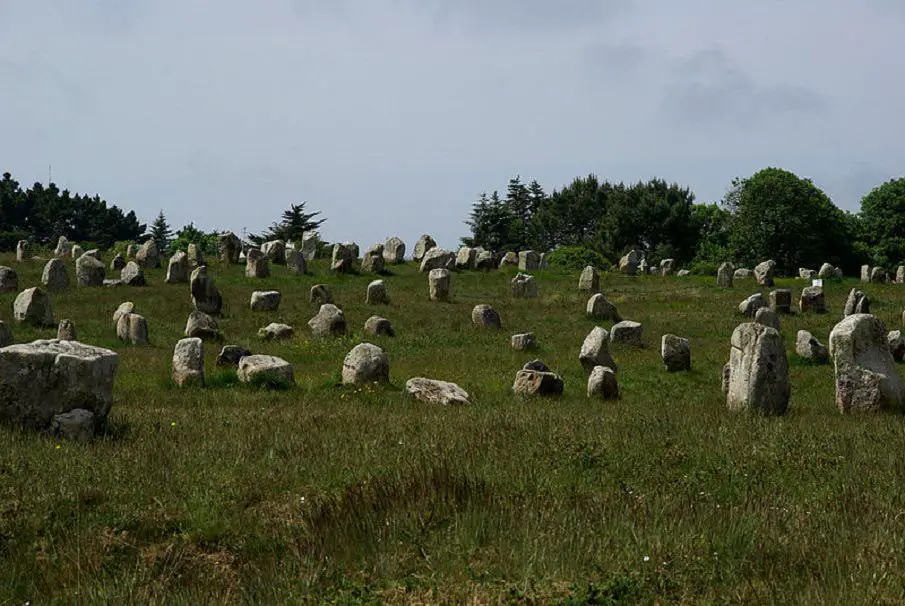
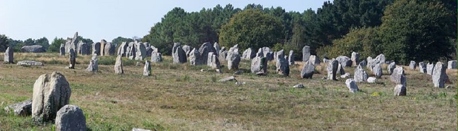
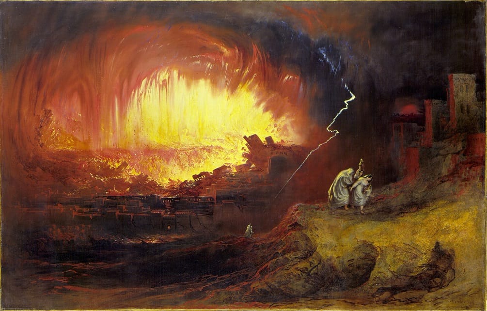


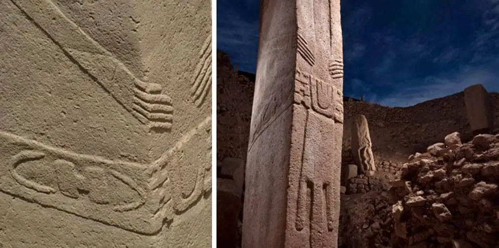

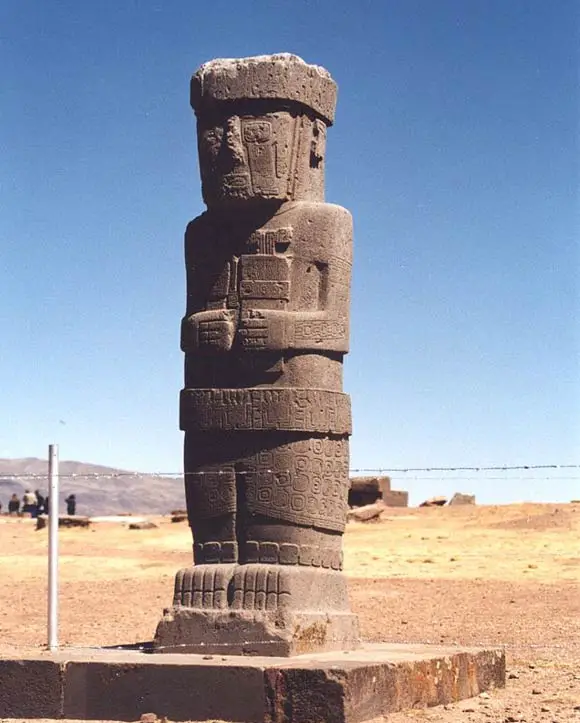
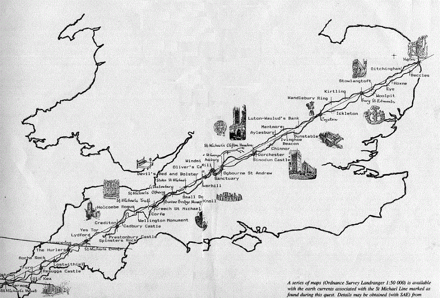


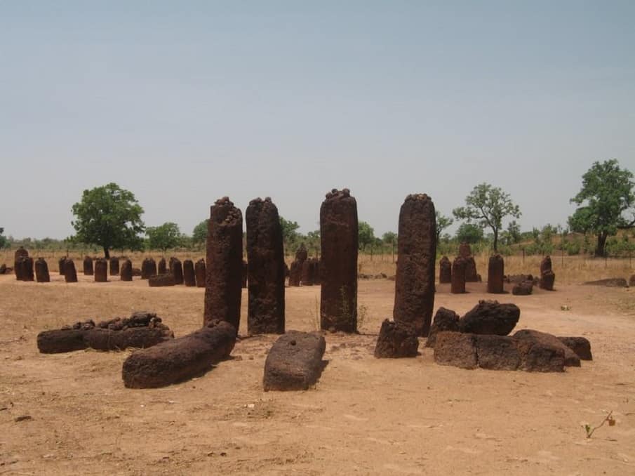
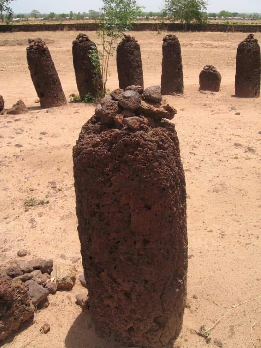
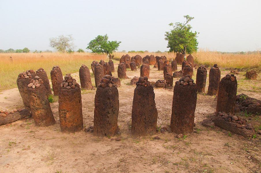
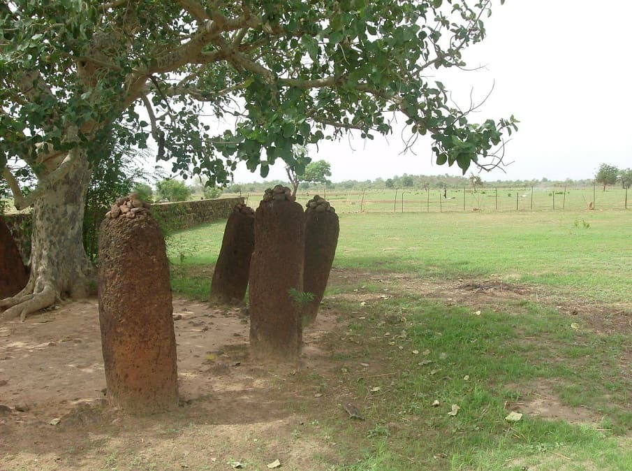
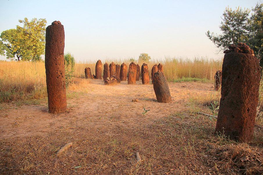
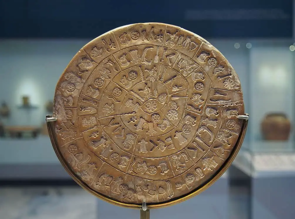
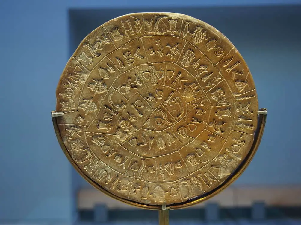
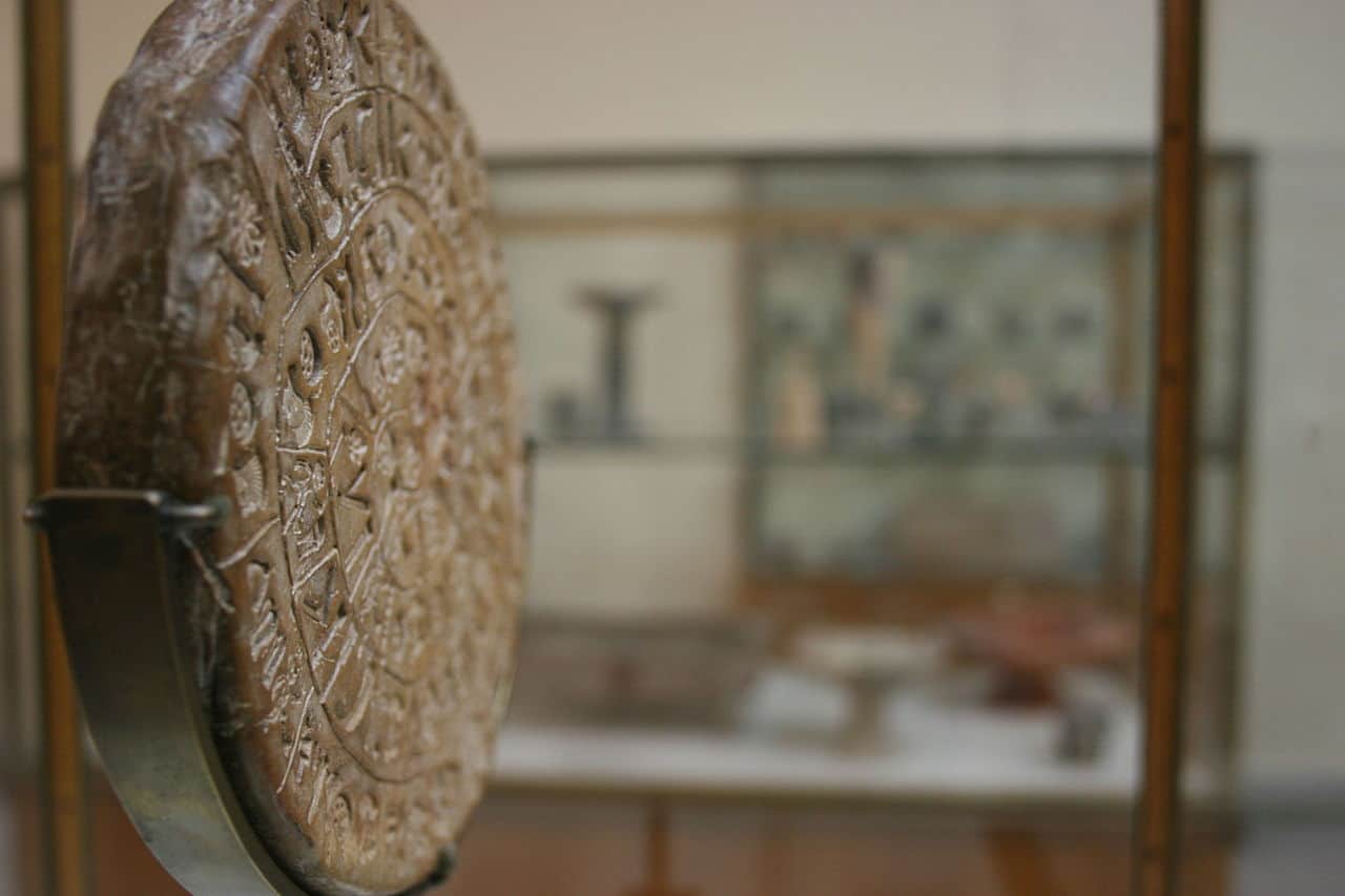
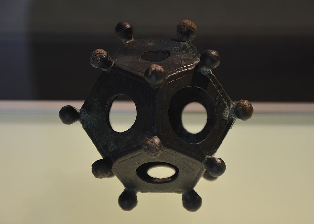


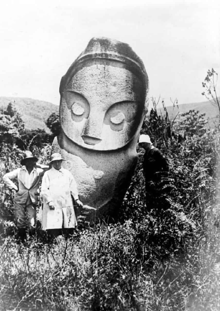
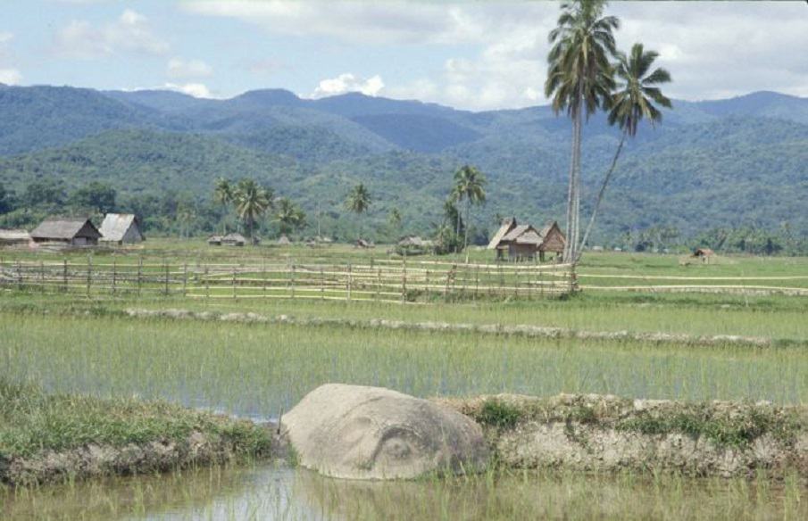


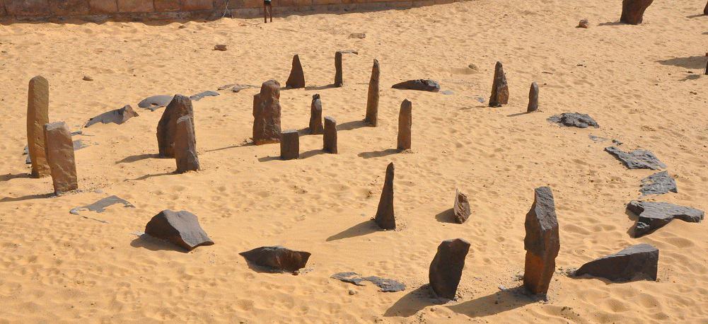


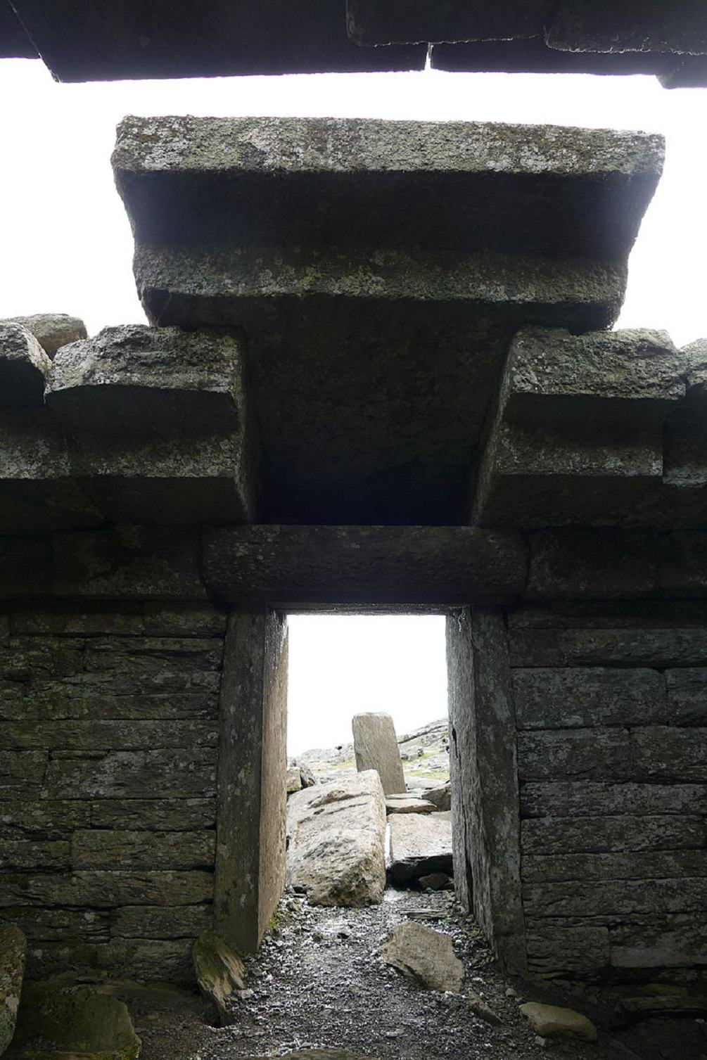
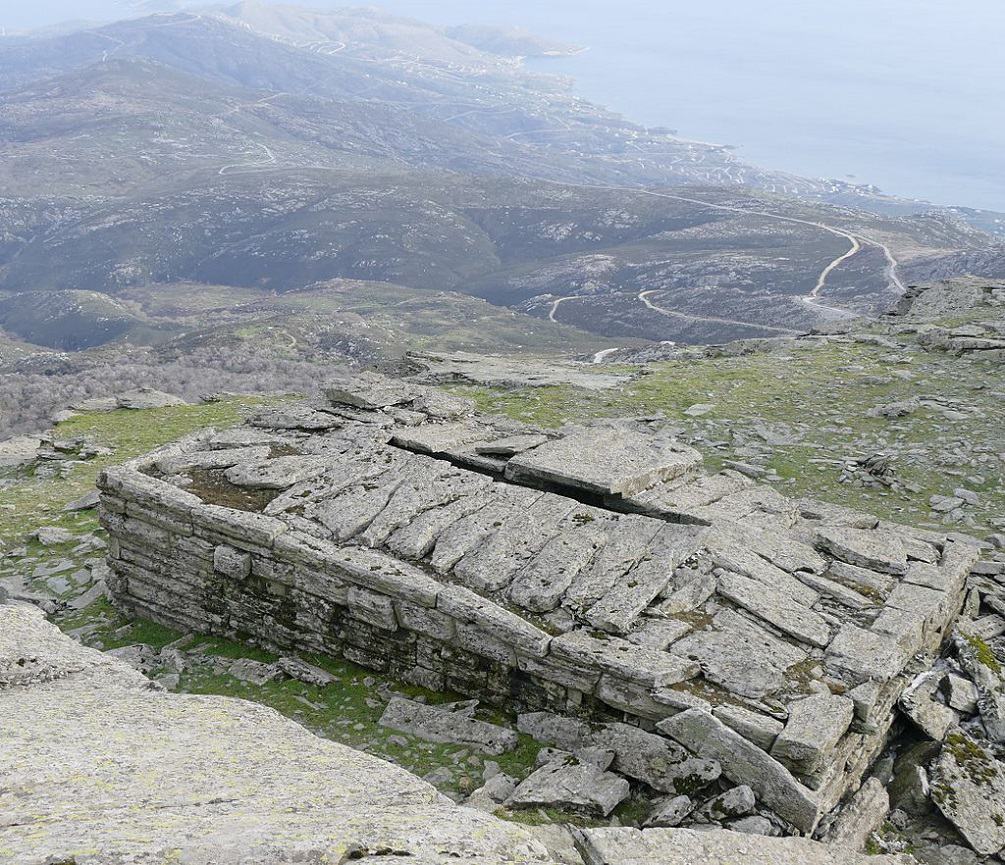

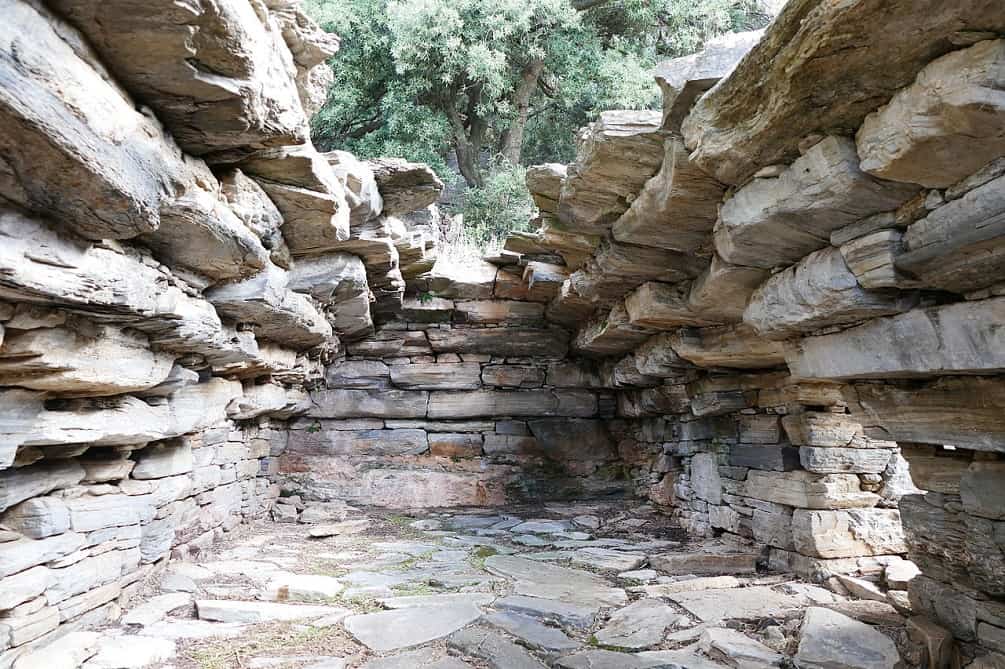


.jpg)