The purpose of this blog is the creation of an open, international, independent and free forum, where every UFO-researcher can publish the results of his/her research. The languagues, used for this blog, are Dutch, English and French.You can find the articles of a collegue by selecting his category. Each author stays resposable for the continue of his articles. As blogmaster I have the right to refuse an addition or an article, when it attacks other collegues or UFO-groupes.
Druk op onderstaande knop om te reageren in mijn forum
Zoeken in blog
Deze blog is opgedragen aan mijn overleden echtgenote Lucienne.
In 2012 verloor ze haar moedige strijd tegen kanker!
In 2011 startte ik deze blog, omdat ik niet mocht stoppen met mijn UFO-onderzoek.
BEDANKT!!!
Een interessant adres?
UFO'S of UAP'S, ASTRONOMIE, RUIMTEVAART, ARCHEOLOGIE, OUDHEIDKUNDE, SF-SNUFJES EN ANDERE ESOTERISCHE WETENSCHAPPEN - DE ALLERLAATSTE NIEUWTJES
UFO's of UAP'S in België en de rest van de wereld Ontdek de Fascinerende Wereld van UFO's en UAP's: Jouw Bron voor Onthullende Informatie!
Ben jij ook gefascineerd door het onbekende? Wil je meer weten over UFO's en UAP's, niet alleen in België, maar over de hele wereld? Dan ben je op de juiste plek!
België: Het Kloppend Hart van UFO-onderzoek
In België is BUFON (Belgisch UFO-Netwerk) dé autoriteit op het gebied van UFO-onderzoek. Voor betrouwbare en objectieve informatie over deze intrigerende fenomenen, bezoek je zeker onze Facebook-pagina en deze blog. Maar dat is nog niet alles! Ontdek ook het Belgisch UFO-meldpunt en Caelestia, twee organisaties die diepgaand onderzoek verrichten, al zijn ze soms kritisch of sceptisch.
Nederland: Een Schat aan Informatie
Voor onze Nederlandse buren is er de schitterende website www.ufowijzer.nl, beheerd door Paul Harmans. Deze site biedt een schat aan informatie en artikelen die je niet wilt missen!
Internationaal: MUFON - De Wereldwijde Autoriteit
Neem ook een kijkje bij MUFON (Mutual UFO Network Inc.), een gerenommeerde Amerikaanse UFO-vereniging met afdelingen in de VS en wereldwijd. MUFON is toegewijd aan de wetenschappelijke en analytische studie van het UFO-fenomeen, en hun maandelijkse tijdschrift, The MUFON UFO-Journal, is een must-read voor elke UFO-enthousiasteling. Bezoek hun website op www.mufon.com voor meer informatie.
Samenwerking en Toekomstvisie
Sinds 1 februari 2020 is Pieter niet alleen ex-president van BUFON, maar ook de voormalige nationale directeur van MUFON in Vlaanderen en Nederland. Dit creëert een sterke samenwerking met de Franse MUFON Reseau MUFON/EUROP, wat ons in staat stelt om nog meer waardevolle inzichten te delen.
Let op: Nepprofielen en Nieuwe Groeperingen
Pas op voor een nieuwe groepering die zich ook BUFON noemt, maar geen enkele connectie heeft met onze gevestigde organisatie. Hoewel zij de naam geregistreerd hebben, kunnen ze het rijke verleden en de expertise van onze groep niet evenaren. We wensen hen veel succes, maar we blijven de autoriteit in UFO-onderzoek!
Blijf Op De Hoogte!
Wil jij de laatste nieuwtjes over UFO's, ruimtevaart, archeologie, en meer? Volg ons dan en duik samen met ons in de fascinerende wereld van het onbekende! Sluit je aan bij de gemeenschap van nieuwsgierige geesten die net als jij verlangen naar antwoorden en avonturen in de sterren!
Heb je vragen of wil je meer weten? Aarzel dan niet om contact met ons op te nemen! Samen ontrafelen we het mysterie van de lucht en daarbuiten.
15-04-2020
‘Holy Grail’ Dating Technique Sheds New Light on Prehistoric Past
‘Holy Grail’ Dating Technique Sheds New Light on Prehistoric Past
A new archaeological dating technique has been successfully applied to shards of pottery uncovered from a dig in East London’s Shoreditch.
The “groundbreaking” new dating technique analyzes fatty acids rather than organic materials, and the University of Bristol scientists who developed the method proved its effectivity by dating ancient pottery samples from sites of known ages. Among them was a collection of pottery fragments discovered beneath Shoreditch in East London, containing traces of meat and dairy products, made and consumed by descendants of Europe's first farmers around 3,600 BC.
Enter: Accelerator Mass Spectrometry Analysis
A new study published in the journal Nature by a team of scientists, from the University of Bristol in England, explains that pottery is one of the most commonly recovered artifacts from archaeological sites. However, pottery is among the most difficult artifacts to date accurately using the traditional radiocarbon dating method, but the new method is based on “accelerator mass spectrometry analysis” of food residues including fatty acids.
Experts at the University of Bristol have developed a groundbreaking new dating technique for pottery (like the fragment of the one pictured, which here is being prepared for dating).
According to the paper, this new dating technique for pottery vessels has several advantages over the traditional method, as it can directly determine the period it was made. It also identifies the origins of the organic residues found on the pottery, which helps scientists map when specific foodstuffs were exploited. What’s more, when testing their new method, they successfully dated dairy and carcass products in Neolithic vessels from Europe and Saharan Africa .
Behold, a Holy Grail of Archaeology
The team’s new method dates pottery with an accuracy to within around “one human lifespan” by analyzing the porous surfaces of pottery, which absorb fatty acids left over from foodstuffs. And speaking of this groundbreaking new method of directly dating archaeological pots, chemist Richard Evershed of the University of Bristol said it’s one of the “holy grails of archaeology.”
Emmanuelle Casanova one of the Bristol scientists who worked on the project loading the Bristol accelerator mass spectrometer with samples for the new dating technique.
Having conceptualized this technique more than twenty years ago, the scientist says it wasn't until the team established their own radiocarbon facility in Bristol that they “cracked it,” according to The Daily Mail .
Before this new method was approved, the researchers had to demonstrate that it could determine dates as accurately as samples of bones, seeds and wood and this was achieved by extracting fatty acids from ancient pottery at a range of key sites across Britain, Europe and Africa, known to be up to 8,000 years old. The British sample is described in The Daily Mail as Neolithic “dirty dishes" dug up in Shoreditch at the Principal Place dig site, which is the foundations of Amazon’s new headquarters.
The Shoreditch excavation site, Principal Place, London.
Shoreditch is a hipster heaven for artists and clubbers and people who like to dress up as 19th century cobblers through the day, and this hub of glassy office blocks interspersed with vintage clothes markets, indie coffee shops and cool co-working spaces is but a modern venire over a deeply ancient landscape.
Comprising 436 fragments from at least 24 separate vessels and weighing a total of nearly 6.5 kilos, the pottery included traces of goat, beef, lamb and dairy products, which the team were able to date to within a window of just 138 years, to around 3,600 BC. This means the poetry was made and used around 5,600 years ago by ‘early East Enders’, descendants of Europe's first farmers who arrived in Britain just four centuries earlier, who we now know ate a diet of dairy products from cows, sheep and goats.
Residues found within the round-bottomed vessel suggest it was used to process meat stew. These fragments were used as part of the new dating technique.
Revealing the Sedentary Secrets of Neolithic Hipsters
This “remarkable collection” from Shoreditch helps to fill a “critical gap in London's prehistory,” according to consultant prehistorian Jon Cotton of the Museum of London Archaeology, and he added that this is the “strongest evidence yet” that the people in the area later occupied by London lived “a less mobile, farming-based lifestyle during the Early Neolithic period.”
This evidence challenges the traditional archaeological view that hunting and gathering was the preferred survival method in the mid fourth century BC by demonstrating the people in what would become Britain’s capital were more sedentary than thought.
Historic England's head of scientific dating, who complied the statistical analysis in the new study, Alex Bayliss, said it is very difficult to overstate the importance of this advance to the archaeological community and that the opportunity to date different kinds of pottery much more securely will be “of great practical significance in the field of archaeology.”
Top image: 6,000-year-old prehistoric pottery from the Sahara Desert, which was subjected to the new dating technique. Source: Emmanuelle Casanova et al. / University of Bristol / Nature
New Crucifixion Evidence Sheds Light on the Death of Jesus Christ
New Crucifixion Evidence Sheds Light on the Death of Jesus Christ
An investigation into crucifixions reveals evidence using the latest medical technology on how the horrific form of execution was slow and excruciating, providing new insights into the death of Jesus Christ.
An Excruciating Death
A new TV documentary on the Smithsonian Channel called Crucifixion Mystery discusses the latest theories by medical experts. Dr. Per Lav Madsen, a Danish cardiologist believes the whole process was to cause immense suffering before death. “ Crucifixion was a horrible way of killing people because it took so long. It was a slow way of dying and that’s the reason they used crucifixion in the first place.”
The length of time and suffering varied, according to Dr. Kristina Killgrove. “Someone might have survived on the cross for as long as four or five days until they died of dehydration.”
Rare Skeletons Provide Insights Into Death of Jesus
The documentary also investigates two rare examples of skeletons believed to have been crucified.
The most recent archaeological discovery was in 2007, when a construction team in northern Italy’s Gavello municipality accidentally uncovered an isolated skeleton from a Roman-era burial. Scientists believed the man who was in his thirties was crucified. Using the latest technological advances to study the skeleton, this could offer up new insights into the death of Jesus Christ .
Grave of the man from Gavello during excavation by the provincial archaeological superintendency.
The research team included Emanuela Gualdi-Russo, Ursula Thun Hohenstein, and Nicoletta Onisto from the University of Ferrara and Elena Pilli and David Caramelli from the University of Florence. They extracted DNA from the remains and were able to rule out an accidental origin for a hole in the calcaneus – the heel bone.
The hole was circular, passing from the inside of the foot to the outside, with evidence showing it was caused at the time of death. “In our interpretation,” the archaeologists wrote in A multidisciplinary study of calcaneal trauma in Roman Italy: a possible case of crucifixion? : “We found a particular lesion on the foot of a skeleton from an isolated Roman burial discovered by excavation in 2007 in northern Italy. Here we suggest crucifixion as a possible cause of the lesion.”
Right calcaneus from 1st c AD Gavello, Italy, showing possible evidence of crucifixion. This archaeological evidence has provided new clues to the death of Jesus.
The researchers believed that “the type of lesion found on the right calcaneus from Gavello is compatible with a position of the body [...] contorted to the right with legs and feet in contact to allow a single nail to pierce both heels, [or with] knees in an open position and feet with heels overlapping and fixed on the medial side by a single nail.”
The skeleton was dated to the Roman era as archaeologists discovered fragments of typical Roman bricks and tiles nearby, which places this crucifixion on or near the time of Christ’s death.
Why did the Romans Use Crucifixion as a Form of Punishment?
This form of execution was reserved for the lowest of the low - slaves, disgraced soldiers, Christians, foreigners and political activists.
During the 1st century AD, large numbers of rebels against Rome were crucified in Palestine. It’s believed that Christ was crucified on the pretext that he instigated rebellion against Rome, who were ruthless in suppressing political dissent.
The first example of possible crucifixion came from an excavation in 1968 of a cemetery in Giv’at ha-Mivtar just outside of Jerusalem. It revealed a heel bone with a nail still skewered through it. Yehohanon ben Hagkol is the name on the tomb – and he may also have been a political activist like Jesus Christ.
The calcaneus of Yehohanon ben Hagkol, with transfixed nail, which provided insights into the death of Jesus.
Even the Romans themselves thought crucifixion was barbaric. The Roman orator Cicero noted that “of all punishments, it is the most cruel and most terrifying.” He added that it was the most “extreme and ultimate punishment for slaves.”
Seneca, the Roman philosopher, described the various ways in which crucifixion took place. “I see crosses there, not just of one kind but made in different ways: some have their victims with their head down to the ground, some impale their private parts, others stretch out their arms,” he wrote in 40AD.
The victim could have also had their eyes pulled out or their tongue excised. One of the worst cases of sadism was recorded by Josephus during the reign of Antiochus IV, where the condemned man’s strangled child was placed around his neck.
The Lex Puteolana tablet reveals the ritual and economics of crucifixion in the Roman world. The 2,000-year-old tablet, now housed in a medieval castle on the Bay of Naples, was found in the town of Puteoli. It’s the only inscription which details the precise practice of crucifixion. The inscription tells us how much the workers who flogged the slaves to be crucified were paid – as well as the executioner. The standard fee for an execution team was four sesterces each – the price of a glass of wine.
In an ironic twist, during later rebellions, the Romans were themselves crucified. According to historians, in AD 9 local Germanic tribes crucified many of the Roman general Varus’ defeated soldiers. In AD 28, the detested Roman tax collectors also met the same fate at the hands of Germanic tribesmen.
How did Jesus Christ die?
The crucifixion of Jesus Christ is believed to have taken place in Jerusalem under Roman rule between AD 30-36. No confirmed archaeological evidence of that event has been found, although Christ is mentioned by Jewish and Roman historians.
Tacitus mentions that Christ was executed while Pontius Pilate was the Roman prefect in charge of Judaea (AD26-36), during the reign of Tiberius. According to biblical accounts, Jesus died after six hours, nailed to the cross. The two thieves who died with Christ were Gestas who was on the left and Dismas on the right.
In Roman law, a person condemned to crucifixion was scourged first, usually with a wooden stave. Short whips with studded leather thongs were also used to flay the skin. The person was stripped naked, tied to an upright wooden post and then flogged across the back, buttocks and legs by Roman legionnaires.
Death may have been due to cardiac arrest after the scourging or dehydration. Many scientists have come to the conclusion that it was progressive asphyxia caused by impairment of respiratory movement. The Roman guards were only allowed to leave once the victim had expired. Due to impatience, the soldiers may have sped up matters by breaking their legs or stabbing the chest.
Shockingly, this horrific form of execution is still used today. Amnesty International recorded a case of crucifixion in Yemen in 2012, when an Islamist group found a 28-year-old guilty of planting electronic devices in vehicles. He was executed first and then hung on a cross.
In Iraq during 2016, a man revealed that his brother-in-law was crucified after being tortured for five hours. “My wife’s brother was crucified by Daesh (Isis),” he told the charity ADF International. “He was crucified and tortured in front of his wife and children, who were forced to watch. They told him that “if he loved Jesus that much, he would die like Jesus.” Isis then cut his stomach open and shot him before leaving him to die on a cross.
Every Good Friday in the Philippines (which is 80% Catholic), a man playing the role of Jesus Christ is nailed to the cross. Since the 1980s, Ruben Enaje has had four-inch nails hammered into both his hands and feet and then hoisted on a wooden cross for around five minute
In 2016, Enaje decided that would be his last crucifixion. The significance was that this was the Filipino’s 33rd time. According to religious tradition, Jesus was 33 years old at the time of his crucifixion.
Top image: Main: depiction of the crucifixion/death of Jesus Christ and the thieves, Gestas and Dismas. (Andrea Mantegna / Public domain ).
Inset: The calcaneus of Yehohanon ben Hagkol, with transfixed nail. ( Israel Museum / Ilan Shtulman)
60,000-Year-Old Underwater Forest May Hold Next Medical Breakthrough!
60,000-Year-Old Underwater Forest May Hold Next Medical Breakthrough!
About 60,000 years ago, pre-historic humans began emerging out of Africa and shared hunting places and cave residences with Neanderthal populationsin what is today Europe. Meanwhile, on the other side of the world, a vast cypress tree forest carpeted riverbanks off the coast of Alabama in Mobile Bay in the Gulf of Mexico. The ancient underwater forest of withering trees and the shipworms they contain were entombed beneath encroaching sediments and sea waters until Hurricane Ivan tore up the Gulf Coast in 2004 and exposed the ancient forest, which was discovered 60 feet below the surface water of Mobile Bay.
The Ancient Secrets of Modern Medicine
A new documentary film by Ben Raines produced by This is Alabama, reveals how dive shop owner Chas Broughton first discovered evidence of the ancient forest and invited an environmental journalist and scientists from the National Oceanic & Atmospheric Administration ( NOAA) to assess his find. The results were published on the NOAA Ocean Exploration & Research website, saying this ancient submerged forest has remained undisturbed for thousands of years and that it holds “the secret to the creation of new medicines .”
300 Ancient Animals Found Entombed in Submerged Forest
A sample of tree sap was recovered from within the bark of one tree, that when cut released resin strong enough to “permeate the air” and the tree’s fibers and growth rings were still visible. Dr. Harley said the tree’s growth rings were narrower and were more uniform in size than those of modern cypress trees, indicating the environment was much colder than our current climate , and Dr. DeLong radiocarbon dated the sample at 40,000-45,000 years old.
Collected from an ancient cypress forest submerged in Mobile Bay, this log contains hundreds of marine organisms that either burrow into the wood or live in burrows made by other organisms.
Last December, NOAA-funded an expedition of scientists from the University of Utah and Northeastern University , and marine and environmental sciences professor Brian Helmuth, who determined that the ancient trees were very well preserved under sediment layers that had prevented oxygenation and decomposition. It was Francis Choi, a senior lab manager at Northeastern University Marine Science Center , who looked at organisms buried within the wood and discovered 300 ancient animals.
This dried specimen of Teredo navalis was extracted from the wood and the calcareous tunnel that originally surrounded it and curled into a circle during preservation. The two valves of the shell are the white structures at the anterior end; they are used to dig the tunnel in the wood.
Sometimes called “termites of the sea,” shipworms are tiny marine bivalve mollusks(saltwater clams) with long, soft, naked bodies, and they are notorious for boring into wood immersed in sea water. As these worms bore their way into organic matter, what comes out the other end is converted into animal tissue.
In this study, one hundred bacterial strains from shipworms, many of which were novel, were dated to being at least 60,000 years old. The team of scientists DNA-sequenced 12 of the strains, determining that they could be applied in the creation of new antibiotics for treatment against “parasites, pain and anti-cancer drugs, antimicrobial activity, and possibly anti-viral drugs”, according to University of Utah medicinal chemistry research professor Margo Haygood.
Ocean Genome Legacy Center Director Dan Distel removes a shipworm. The bacteria that shipworms create may lead to new life-saving medicines.
This is not the first time scientists have studied shipworms in a medical context, in 2017 a paper by Northeastern University scientists titled “'Unicorn' shipworm could reveal clues about human medicine, bacterial infections” was published by Science Daily . Researchers discovered a “dark slithering creature four feet long” dwelling in foul mud in a remote Philippines lagoon and this “giant shipworm”, with pinkish siphons at one end and an eyeless head at the other, was said to have added to the scientific understanding of how “bacteria cause infections and, in turn, how we might adapt to tolerate, and even benefit from them.”
According to East Idaho News , the COVID-19 pandemic has put a stop to diving at the ancient forest site in the Gulf of Mexico, but Dr. Choi and his team plan to launch unmanned underwater robots to provide 3D visualizations of the forest and Dr. Haygood and her team plan to study more tree samples next year, which NOAA said might have applications in “textile, paper, food, renewable fuel, animal feed, and fine chemical production.”
Top Image: Wood from an ancient bald cypress forest buried off the coast of Alabama was uncovered by storms. Newly exposed wood offers a unique habitat for marine organisms and creates a novel ecosystem in the Gulf of Mexico.
The 40,000 Year Old Legacy of the Advanced Siberian Denisovans Giants
The 40,000 Year Old Legacy of the Advanced Siberian Denisovans Giants
COAST TO COAST AM – Andrew Collins has been investigating the idea of advanced civilizations in prehistory since 1979. In the latter half, he spoke about the legacy of the Denisovans, an extinct species of hominins that lived in Siberia around 40,000 years ago, and whose existence was just discovered in 2010.
Collins believes they developed sophisticated technology, using high-speed drilling techniques and creating unique jewelry and musical instruments. The Denisovans, who were large in size and may have been the source of legends about giants (such as the Nephilim) were fascinated by celestial movements, he noted.
Evidence of New Human Species Discovered in a Cave in the Philippines
Evidence of New Human Species Discovered in a Cave in the Philippines
There were once many human species, but today there is only one; modern humans, Homo sapiens. However, the human family tree is growing. Researchers working in a cave in the Philippines claim to have found a new, previously unknown species to add to human history.
Remarkably this hominin was probably less than four feet high and had some of the characteristics of modern people but also anatomical features from much earlier hominins . It is believed that the discovery will transform the understanding of our evolution.
New humans found in the Philippines
In recent years there have been a series of finds of early humans in the Philippines. The latest was made by archaeologists as they were digging in the ‘rocky floor of Callao Cave on Luzon island’ according to History.com. A team of experts found a number of fossils that are unlike anything else in the world. They were unearthed by a team of experts led by Professor Philip Piper, from the Australian National University.
According to the Daily Mail , “the fossil remains included adult finger and toe bones, as well as teeth.” The femur bone of a juvenile was also unearthed. The remains are estimated to be about 50,000 years old, at a period of time in the Pleistocene when several human species co-existed on the planet. A preliminary examination of the remains indicated that they came from an ‘unknown species of hominin’ according to Haaretz.
The five upper teeth found belonged to a single individual of previously unknown hominin, provisionally named ‘Homo luzonensis’. The have a strange mix of Australopithecine and modern features.
The stunning discovery has been provisionally named Homo luzonensis . The new species had some of the same characteristics of modern humans , in particular, its molars. However, they also had characteristics of a far earlier species namely of Homo australopithecus . This hominin was the ancestor of many human species including Homo erectus and lived between 2 and 3 million years ago. The Daily Mail reports that ‘hand and feet bones, are remarkably Australopithecine-like’.
Despite these similarities, the shape of the tooth and the anatomy of the feet shows that they are a unique human species. The slight but significant difference are such that taken together they strongly indicate that Piper and his team have unearthed a new species. What is most striking about the new species was their estimated height, possibly just under four feet.
The height of the new humans was determined by the size of the tooth and the other bones. However, more evidence is required to confirm this. If the size is confirmed, it is raising the possibility that the hominins are somehow related to another species found in the Indonesian island of Flores . This hominin is Homo floresiensis and stood under four feet high. Because of their diminutive stature, they are popularly known as the Hobbit.
An examination of the foot bones found morphological features that come from both earlier and later hominins. This could indicate that they had a particular way of walking. According to Science Mag , the human had ‘long, curved fingers and toes’. This means that it was as comfortable scrambling up trees as walking upright. This would seem to suggest that it ‘might have descended from an earlier human relative, H. erectus , that somehow crossed the sea to Luzon’ reports the WRAL.com.
The proximal foot phalanx of Homo luzonensis. Notice the longitudinal curvature of the bone, which suggests that this species was adapted to climb trees.
According to History.com ‘human evolution was clearly much more complex’ in Asia than previously assumed. It seemed that H. erectus in evolved in the region into new species such as that possibly found in Luzon. It appears that the human evolved in a unique way on the island of Luzon, very different from those on mainland Asia. Science Mag reports that many experts “suspect the islands of Southeast Asia may have been a cradle of diversity for ancient humans.”
New theory on human evolution
The find is casting doubt on the accepted theory of how humans evolved and spread out over the globe. The first wave of our relatives to leave Africa was made up of H. erectus and the second wave was H. sapiens . It was thought that H. erectus settled in Asia and it was the only human in Asia until the arrival of modern humans. The discovery of H. luzonensis , along with the earlier discovery on Flores have upturned this theory.
More work needs to be done to establish if the human remains found on Luzon are from a new group of hominins. At present, there are approximately 12 human species recognized but there is no agreement as exactly how many have been identified. It seems likely that the humans whose bones were found in the Callao Cave may be another one of our relatives and will add greatly to our understanding of human evolution.
Top image: Callao Cave, Luzon Island, Philippines where the bone and teeth of the new human species were found.
The excavation of the site, known as Kunara and located near the city of Sulaymaniyah, was only possible after Iraqi dictator Saddam Hussein was deposed in 2003. Researchers also noted that the ISIS terrorist group’s presence in Iraq also hampered their efforts.
“The situation is much more favorable now,” project leader Aline Tenu said in the journal.
4,000-Year-Old "Lost" City That Bordered Ancient Mesopotamian Empire.
Credit: Tenu/Mission Archeologique Francaise du Peramagron
According to the journal, “This city stood in the heart of an unknown kingdom: that of the mountain people, who had until then remained in the shadow of their powerful Mesopotamian neighbors,” including the Akkadians. The Akkadian Empire is considered the first ancient empire of Mesopotamia and reached its peak about 4,000 years ago under ruler Sargon of Akkad . After its fall, historians believe it split into Assyria and Babylonia.
People lived in the city, located near the Zagros Mountains, around 2200 BC, archaeologists have theorized.
“The city of Kunara provides new elements regarding a hitherto unknown people that has remained at the periphery of Mesopotamian studies,” Tenu added.
The lost city was found near the Zagros Mountains,
pictured (sghiaseddin / Adobe Stock)
Meanwhile, dozens of clay tablets covered in cuneiform were also discovered, which showed how people may have delivered flour. Cuneiform is one of the oldest systems of writing.
Researchers said the city underwent a period of decline after it was ravaged by a fire 4,000 years ago, the researchers speculated.
Cuneiform specialist Philippe Clancier said the people who lived in the city had a good “grasp of Akkadian and Sumerian writing, as well as that of their Mesopotamian neighbors.”
An Akkadian tablet
(public domain)
“The first tablets found in a building of the lower city register a large number of entries and departures of flour,” Clancier continued.
“It was actually a kind of flour office,” Tenu explained, adding that it was for the governor of Kunara.
“The city must have even been fairly prosperous,” Tenu noted. “As rare stones such as obsidian [and carnelian, a semi-precious gems stone] were used to produce entirely commonplace tools.”
Residents in the city “most likely took advantage of its strategic location on the border between the Iranian kingdom in the east and the Mesopotamian kingdom in the west and south,” Kepinski also theorized.
Researchers also discovered tools and ceramics that were bought and traded in the city’s ruins.
“It was surely the area’s agricultural wealth that promoted its rise. Archaeologists have discovered the remains of goats, sheep, cows, and pigs, suggesting the existence of a major livestock farming system. The presence of an irrigation network in the city’s south is also a reminder of the mastery the region’s inhabitants achieved in grain farming, especially barley and malt,” the journal also noted.
They haven’t found anything about the city’s original name, which is still a mystery, “But we will continue to look,” Tenu added.
Top image: 3D reconstruction of an ancient Mesopotamian city. (Satori / Adobe Stock)
Beyond the Pyramid Ramp: Unravelling Egypt’s Most Elusive Enigma
Beyond the Pyramid Ramp: Unravelling Egypt’s Most Elusive Enigma
The mystery of how the Pyramids of Giza in Egypt were built continues to elude scholars, even in the 21 st century. As famed Egyptologist Flinders Petrie records in his The Pyramids and Temples of Gizeh (1883): “The means employed for raising such masses of stone is not shown to us in any representations.” The brightest minds in the world still wrestle with competing ideas, offering educated guesses based on incomplete evidence.
Every theory begins with the inclined plane, or the pyramid ramp. This idea was first mentioned two millennia ago by the Greek historian Diodorus Siculus, who recounted what the Egyptians told him about the pyramids: "It is said that … the construction was undertaken with the help of ramps of earth, since at that time cranes had not yet been invented." (Library of History 1. 63).
Many Theories for the Pyramid Ramp
By the end of the 19 th century, Petrie had carefully measured the Pyramids of Giza , particularly the Great Pyramid of Khufu, and determined that the likeliest manner of their construction was using a single, long ramp, with a smaller zig-zag ramp near the summit. Since then, this idea has largely been discredited due to lack of evidence, and other theories have taken its place.
Three types of single, straight pyramid ramps to build that could have been used in the construction of the ancient site.
Late German Egyptologist Uvo Hölscher believed the Egyptians employed a short ramp that zig-zagged all the way up the face of the pyramid, while Dieter Arnold, the German archaeologist who wrote the famous Building in Egypt (1991) believes a long ramp was used, but that it cut through the center of and was partially composed of the pyramid itself.
Meanwhile, Giza archaeologists Zahi Hawass and Mark Lehner believe the material evidence most clearly points to a spiral ramp that would have twisted up the exterior of the pyramid, either resting against the structure or on a large earthen mound. They suggest that water or milk would have been used to lubricate wooden sleds strapped with stone blocks, similar to a scene from the Middle Kingdom tomb of Djehuti-hotep (~1900 BC).
Three different pyramid ramp proposals, by Uvo Hölsher (left), Dieter Arnold (center) and Mark Lehner (right).
Numerous recent experiments have confirmed this possibility, including a study in 2014 by Daniel Bonn and other scientists from the FOM Foundation and the University of Amsterdam that demonstrated the right proportion of water on sand could reduce the required people hauling a block by half. There is also a depiction on a New Kingdom stela showing six oxen pulling a block on a sled (~1575 BC), and many actual sleds have been recovered.
What About the Evidence?
Evidence of earth ramps do exist in Egypt. The best example comes from the Temple of Karnak at Thebes, where it can be found still leaning against the back of the towering First Pylon. Made of mud brick, it was never completely disassembled, and it stands today as testament to the manner in which these large stone structures were built and decorated. Further examples come from the abandoned step pyramid of Sinki at Abydos. Likely built by Huni, Sneferu’s father and Khufu’s grandfather, this pyramid has four construction ramps still in place, composed of two outer mud-brick walls with an interior fill of debris and stone chips.
Remains of an ancient mud-brick ramp at the Temple of Karnak at Thebes (First Pylon, New Kingdom).
Amazingly, the potential construction ramp of the Great Pyramid has already been discovered, and it was similar to these other ramps. In 1995, the Giza Inspectorate “excavated trenches through thick layers of limestone debris south of the southwest corner of Khufu’s pyramid. Remains of fieldstone walls were found running north-northwest that could have been the accretions or retaining walls of the foundation of (such) a supply ramp.” (Lehner, 2017; 440).
According to Hawass, this lower section of the ramp: “consisted of two walls built of stone rubble and mixed with “tafla” (a calcareous clay). The area in between was filled with sand and gypsum forming the bulk of the ramp.” (Hawass, 1998; 58). He calculated the ramp would have reached ~30m (98ft) above the pyramid’s base, or roughly 20% of the pyramid’s original total height of 146.7m (481.3ft). Beyond that he believes the ramp would have spiraled up the exterior of the structure.
Map of the Giza Plateau, showing newly-discovered ancient ramp in red line at southwest corner of Khufu’s pyramid, and quarry and authors’ proposed wooden scaffolding running up to the top (red and brown lines added by author).
In late 2018, the remains of a ramp were found in the ancient alabaster quarry at Hatnub, from the very time of Khufu. It reveals how the Egyptians could have moved tremendously heavy blocks of stone by using physics to aid them. Archaeologists from the French Institute for Oriental Archaeology and the University of Liverpool excavated a ramp with flights of stairs on either side, and with post-holes near the stairs running all the way up the ramp.
It has been suggested by the excavating team that by using ropes tied around wooden posts, ancient workers could have hauled large blocks much easier by using gravity to pull down rather than pulling up. They could also control the blocks better, which are imagined as having rested on wooden sleds attached to the ropes.
Ancient ramp discovered at Hatnub, Eastern Egypt, in 2018, similar in shape but smaller in dimensions than the pyramid ramps that could have been used to build the contemporaneous site at Giza.
The addition of ropes and wooden poles to change the direction of force could have effectively doubled the ramp grade, meaning any ramps on the pyramids would have only needed to have been half their projected size. This could have potentially doubled the grade of Khufu’s ramp, discovered in 1995, up to ~60m (197ft), or 40% of the pyramid’s original height (and most of the volume).
However, problems persist. A ramp that spiraled around the pyramid would be impractical because of the inability to back-sight each corner to remain true, its massive size (rivalling the pyramid itself), and the lack of any archaeological evidence. So if the builders did use a ramp, where was it? An ingenious architect named Jean-Pierre Houdin thought he had the answer.
A Hidden Ramp Inside
Perhaps no other theory in recent years has garnered as much attention as that of the Great Pyramid’s supposed ‘internal ramp’, an idea first proposed by the French architect Jean-Pierre Houdin in 2005. Aided in his exploration by Egyptologist Bob Brier, they flew to Egypt to hunt for evidence of this proposed inside-ramp.
In essence, Houdin proposed that the Egyptians had built an internal ramp just inside the perimeter of the structure that wound its way up as the pyramid rose, composed of corbelled ceilings and corner notches in which the blocks would be rotated on rope cranes. This would seemingly eliminate the need for external ramps, levers, cranes or scaffolding.
Several lines of evidence jumped out at the researchers as proof of their idea. First, Houdin detected faint ‘phantom’ lines within the masonry of the pyramid that ran at ~7°, the exact angle he determined the internal ramp must run at.
Second, there is a mysterious ‘notch’ on the northeastern edge of the pyramid, where Houdin had predicted was an original ‘corner block-turning station’. This ‘notch’ was explored by Brier, who found a small irregular chamber (‘Bob’s Room’) but nothing more.
Third, in 1986 a French team completed a microgravimetric study of the pyramid, and the resultant CG-image of low- and high-density areas revealed an image consistent with an internal ramp.
Attractive Theory But Where is the Evidence?
Despite how attractive this theory seemed at first, many noted it was an unlikely scenario. Egyptologist David Jeffreys called it “far-fetched and horribly complicated,” for it proposed the pyramid is vastly more complicated than presently believed. Instead of having four internal chambers and corridors, it would actually have the equivalent of dozens of internal chambers. Instead of having one impressive and corbelled Grand Gallery, it would have the equivalent of over thirty grand galleries winding up through the monument, all corbelled corridors of impressive masonry.
It seems absurd, considering how amazing a feat the Grand Gallery itself was, that there would still be thirty more of them to discover somewhere inside the pyramid, all connected together. And despite much indirect evidence, Brier and Houdin have not found any specific hard data for their ramp. Even their much-lauded microgravimetric scan could be interpreted differently, such as via the model of internal ‘steps’.
The Grand Gallery in the Great Pyramid of Giza. Houdin’s theory would require another 30 of these inside the pyramid.
Now, despite the difficulties with the idea, it remained a promising theory in need of independent verification. Fortunately, the ‘Scan Pyramids Mission’ ( scanpyramids.org) would be its ultimate test. Beginning in 2015, this study was based on the idea of using cosmic particles called muons to remotely scan the pyramid for void spaces, an idea first employed by famed physicist Luis Alvarez in the late 1960s on Khafre’s pyramid.
Large collectors were set up in the Great Pyramid and the muons that streamed through the structure were measured in the hopes of identifying any hidden chambers. The idea that a beautiful internal passageway snaking up through the structure would be revealed had millions of excited archaeology buffs on the edge of their seats. Then the results came in.
While a large void was detected above the Grand Gallery, no internal ramp was detected. Nada. This deflationary news was relayed by the theory’s first expert supporter, Bob Brier himself: “these data suggest that the ramp is not there. I think we’ve lost.” So if there was no internal ramp inside the Great Pyramid, then how was it actually built? How were the stones lifted skyward hundreds of feet, beyond the ramp?
New research looking at the density of particles called muons has found an empty space (shown in this illustration) more than 98 feet (30 meters) long right above the Great Pyramid's Grand Gallery, but no internal pyramid ramp was found.
Any theory based on ramps, whether internal or external, runs into problems near the apex of the pyramid. Lehner and Hawass admit that: “the fact that the four sides of the pyramid narrow towards closure at the top means that the builders ran out of room for ramps.” (Lehner 2017; 418), and that: “it is very possible that levering was the only means to raise the blocks of the highest courses, near the apex, once the builders had brought them as high as they could on ramps.” (Lehner, 2017; 417).
Other archaeologists have suggested a combination of ramps and levers, including Martin Isler in On Pyramid Building I & II (1985 & 1987).
The idea the ancient Egyptians used other technologies besides ramps was first put forth by Herodotus in 425 BC. He describes the construction of the Great Pyramid thusly: “This pyramid was made after the manner of steps, which some call ‘rows’ and others ‘bases’: and when they had first made it thus, they raised the remaining stones with machines made of short pieces of timber, raising them first from the ground to the first stage of the steps, and when the stone got up to this it was placed upon another machine standing on the first stage, and so from this it was drawn to the second upon another machine.” (Histories 2. 125).
“Construction of the Great Pyramid According to Herodotus”, lithograph depicting multiple so-called ‘Herodotus Machines’ operating on the Great Pyramid
This description calls to mind a ‘liftjack’ tool, which uses levers and small shims, or wedges, to gradually lift a large block in many small increments. This was first suggested by Petrie in 1883: “for the ordinary blocks, of a few tons each, it would be very feasible to employ the method of resting them on two piles of wooden slabs, and rocking them up alternately to one side and the other by a spar under the block, thus heightening the piles alternately and so raising the stone.”
Several other scholars have noted this theory as well, including Isler, who actually tested this theory during a 1991 Pyramid building project filmed for NOVA. He discovered it was harder and took much longer than he anticipated, but mainly due to his lack of experience and the instability of his wooden support cribbing.
Assisting with this method may have been mysterious rounded wooden objects colloquially called “Petrie rockers”. Found by the famed Egyptologist at Thebes, he proposed these semi-circular wooden devices could have been used to help jack up heavy blocks by allowing them to tilt back and forth easier ( “rocking them up alternately to one side and the other”) , allowing successive planks to be inserted on either side and lifting the block.
Others like Paul Hai imagine the Egyptians actually “rolled” the large blocks by lashing a Petrie rocker to each side of the block, creating a cylinder. Again, there is no evidence for this, and there have never been found any of these wooden rockers near the pyramids.
A model wooden “rocker” device found by Flinders Petrie at Thebes, from the New Kingdom, ~1450 BC.
Alternatively, the Egyptians could have employed a counter-weight levering mechanism, similar to the shaduf, which has been used for millennia to lift water from the Nile. The machines described by Herodotus could have been composed of wooden beams with counterweights, used to see-saw the blocks up course-by-course.
Tomb painting showing an ancient Egyptian gardener using a shaduf (Tomb of the Royal Sculptor Ipuy, Deir el-Medina, 19th Dynasty, 1279-1213 BCE). The shaduf relies on the same principles of counter-weight leverage as the so called “Herodotus Machines” imagined by Goguet and other artists.
Other researchers such as Peter Hodges, Julian Keable, Louis Croon, and Robert Scott Hussey-Pailos have all made improvements on these designs, decreasing Isler’s original lifting time of over an hour down to only minutes. Whether the Egyptians used a rocker-shim-lever or counter-weight-lever method, they would have also needed some degree of wooden scaffolding.
We have no painting or material remains of any of these proposed lifting devices, but we do have evidence the Egyptians were familiar with wooden scaffolding. In a painted scene from the tomb of the Vizier Rekhmire in Thebes (~1450 BC), we can see several workers standing (and even sitting) on a scaffold while they polish and paint a large statue.
Depiction of wooden scaffolding from the Tomb of the Vizier Rekhmire, ~1450 BC.
(Metropolitan Museum of Art / Nina De Garis Davies / Public domain )
An earlier scene from the Fifth Dynasty Saqqara tomb of Khaemhesit shows a vertical wooden ladder with workers perched along it, and surprisingly wheels and an axle at its base! This is the only known Old Kingdom depiction of wheels, and the Egyptians did not use them to move the heavy pyramid blocks: wheels would have sunk into the ground, and there was no material strong enough for the axles.
Many researchers have suggested scaffolding was used to help build the pyramids, as far back as Somers Clarke and R. Engelbach in their classic Ancient Egyptian Construction and Architecture (1930). Hawass, Lehner, and Isler have likewise voiced limited support for the idea, along with James Frederick Edwards in his article Building the Great Pyramid: Probable Construction Methods Employed at Giza (2003). He notes in particular the likely use of scaffolding by the masons to dress the fine-white Tura casing stones, generally believed to have been the final stage of construction. Perhaps the most vocal supporter of the idea of wooden scaffolding is the Welsh structural engineer Peter James, who was called upon to save the Step Pyramid after being damaged in a 1992 earthquake.
As detailed in his 2018 book Saving the Pyramids, James and his team worked deep under the Step Pyramid in Djoser’s burial, using large air bags in conjunction with wooden scaffolding to prop up the sagging ceiling. They carefully drilled narrow holes into the superstructure, inserting steel rods and then cementing them in place, finally securing the 4,700-year-old building - the world’s oldest stone building - from collapse.
Modern wooden scaffolding set up around Djoser’s Step Pyramid at Saqqara
However, it was the abundant wooden scaffolding that was set up around the Step Pyramid to restore its crumbling façade that gave James an idea about its construction. He thought that similar scaffolding could have been used in the past, composed of pieces of timber lashed together: “In recent restoration work on the pyramids, traditional timber lashed together has been used as scaffolding, which demonstrates that it clearly would have been possible to use scaffolding to construct them in the first place.”
“We Have People, We Need Wood”
Most scholars dispute the notion that scaffolding served any primary construction role, relegating it to a minor function, such as dressing the casing stones or laying the very top courses of masonry. It remains an unpopular idea for one simple reason: most Egyptologists believe that the ancient Egyptians, with their dry and relatively treeless environment, had limited access to timber.
However, several scholars have demonstrated that the Egypt of the Old Kingdom, ~2550 BC, would have had more vegetation than today. Researchers have demonstrated that a major climate change accompanied or perhaps caused the end of the Old Kingdom of Egypt around 4200 years ago. For example, Jean-Daniel Stanley and his colleagues, using strontium isotopes and petrologic data, showed in their 2003 study that Nile levels, and consequently tree populations, dropped drastically between 2200-2000 BC.
As D.M. Dixon states in his article Timber in Ancient Egypt (1974), “in antiquity, Egypt possessed, and still does, a number of trees capable of providing timber.” These include the date palm, acacia, tamarisk, persea, willow, sidder, moringa, and sycamore-fig. These trees were used for boat construction, to make furniture, huge temple doors, coffins, bows, arrows, and ramps, as described on the Papyrus Anastasi I: “There is to be constructed a ramp … consisting of 120 compartments filled with reeds and beams.”
Left: acacia tree, similar to what would have been found in Egypt and across the Levant during Khufu’s time, Israel’s Negev Desert. (Mark A. Wilson / Public domain ). Right: avenue of acacia trees leading towards the pyramids in 19th century Cairo
Archaeological evidence of wood inside ancient ramps has been found at Lahoun, Lisht, and Deir el-Bahri. We also know that Egypt imported huge beams of cedar and cilician fir from Lebanon, confirmed by the discovery in 1954 of two deconstructed funeral boats of Khufu buried beside his pyramid.
Al Arzz above Bsharri (Forest of the Cedars of God), Lebanon.
Made of gigantic beams of cedar, they were lashed together with rope and would seal by swelling in the water. We know from the Palermo Stone inscription that Pharaoh Sneferu , father of Khufu, sent an expedition of forty ships to Lebanon to collect prized cedar beams: “Bringing forty ships filled [with] cedar logs … Shipbuilding [of] cedar wood, one ship, 100 cubits [long].” 100 cubits was roughly equivalent to 50 meters (164ft), even longer than Khufu’s boat at 43.6m (143ft).
The magnificent Boat of Khufu, Solar Boat Museum, Giza.
We can still see the massive fifty-foot (15m) cedar beams that Sneferu’s engineers wedged between the walls of the Bent Pyramid’s burial chamber to keep it from collapsing. He could have easily used similar beams to construct wooden scaffolding for the construction of his two pyramids at Dashur (and earlier structure at Meidum).
Ancient wooden beams still inside the Bent Pyramid of Sneferu at Dashur.
An interesting feature of the solar boats is that their beams were held together entirely with hemp rope, which was also preserved beside the boat. Having cedar beams and sturdy rope, the Egyptians could certainly have built a robust scaffolding capable of supporting large stone blocks and multiple workers.
I believe the secret to building the pyramids, beyond the ramps anyways, was actually very simple: a relatively narrow section of wooden scaffolding, lashed together with ropes and anchored securely at the base. This would have rendered unnecessary large external mud brick ramps, internal stone ramps, and the need to dress the stone from the top down. The entire structure could have been completed level-by-level, with the exterior stone dressed before the next layer was begun (or even in the quarry when first removed, when it is softer and easier to carve, as noted by Bob Brier).
I believe work gangs would have used a combination of levers, rockers, and wedges to lift the blocks up through the scaffolding to the active building surface, where other gangs would have taken over. The scaffolding itself would have had dedicated wood-working teams building it as the pyramid rose. Each level of scaffolding would have had separate teams, while the teams operating on the pyramid would have likely been divided again.
Most work gangs would have focused on the inner fill and less precise masonry of the interior, some would have focused on the core blocks and grout, while the most skilled would have been stationed around the exterior to set and finish the precisely-angled and highly polished Tura limestone casing blocks. I therefore imagine an assembly-line type of process, from quarry to pyramid, with teams remaining at their spots and the rocks moving between them.
There is no good reason the Egyptians couldn’t have built a narrow stretch of scaffolding up the south side of the Great Pyramid through which to lever-up all the necessary blocks for its construction. It could then have been removed very quickly and re-used at further pyramid projects or alternatively used for solar boats, coffins, etc. The re-use of wood was common in Egypt, as demonstrated by Pearce Paul Creasman in his article: Ship Timber and the Reuse of Wood in Ancient Egypt (2013).
The pyramids were built with the available technology during the Old Kingdom: ramps, bronze chisels, stone pounders, levers, ropes, poles, plumb bobs, cubit rods, mallets, adzes, wedges, and squares. To these primitive yet capable tools, I believe, we can add wooden scaffolding, the final missing piece to the puzzle of their construction.
It was more than this technology, however, that helped realize these massive building projects. It was the organization and hierarchy of workers, overseers, priests and scribes that helped to bring to fruition these huge state dreams. It was the skilled coordination of this hard-working society, all based on the careful measurements by priests of the seasons, sky and Nile, that ultimately built the pyramids. It was a nation-wide effort, one of the largest in our history, to serve the kings, the gods, and to preserve balance in the land, so that their names and works would last forever.
End Note
Interestingly, Welsh architect and pyramid rescuer Peter James does dispute the idea the Egyptians used poles and ropes to increase their ramp grades at pyramid sites, as suggested by the new ramp discovery at Hatnub. In a personal email communication he discusses several flaws he has identified with this model:
“The question of the size and diameter of the ropes needed to haul the heavy blocks is an issue and also their durability on the edges of square blocks. The method of attaching the ropes to the blocks that would avoid twisting the blocks as they are lifted would also be a problem.
How would you make sure that the two sets of operatives pulling up the blocks would be able to provide the same tension in the ropes to control the lift and not induce twisting and movement of the blocks, particularly as they are on temporary constructed steps? This would be a very dangerous operation.
The same goes for the temporary wooden post that may have been good in a permanent position in a quarry but would be prone to movement under load on unconsolidated substrate and again would cause difficulties controlling the blocks; also the leading edge of the block would dig into the soil and any force used to move it would rotate the block into the soil and prevent further movement.”
Top 15 Interesting Facts About Ancient Egypt That You May Not Know
Top 15 Interesting Facts About Ancient Egypt That You May Not Know
One of the greatest civilizations in our history belonged to the ancient Egyptians. It flourished in the fertile valleys of the world’s longest river - the Nile, where a magnificent civilization rose from the surrounding sands and lasted for roughly 3,000 years. Rising above beast and nature, these ingenious people became a unique culture of the world.
The ancient Egyptians brought to life a variety of gods and goddesses, and fashioned a colorful and natural mythology by which they governed their lives. As time went on and their advancements grew, the Egyptians pioneered some of the world’s first technologies - mathematics, papyrus making, writing systems, medicine and pyramid building. They gave us some of the finest achievements of humanity - which remain stunning and marvelous to this very day. And to celebrate this grand ancient civilization, we are going over the top 15 interesting facts about ancient Egypt!
Our List of the Top 15 Interesting Facts About Ancient Egypt
A civilization that flourished for approximately 3000 years had to be rich, well developed, vast and inspiring. And the ancient Egyptians were all this and more. To get better acquainted with this, we have assembled a list of the most amazing aspects of ancient Egypt.
From arts and entertainment, to religion and law, all the way to war and science - we will delve deeper into the most astonishing achievements of one of the world’s most amazing ancient civilization. Of course, it is difficult to put 3 millennia into a single article, but it should be enough to give you an idea that there are a lot of truly interesting facts about ancient Egypt, and that it definitely bears a passionate study.
The Pantheon
One of the most astonishing features of the ancient Egyptian civilization is their pantheon and in particular, the sheer amount of diverse deities and beings - today we know more than 1,500 of them by name.
Ancient Egyptian gods (Amun-Ra and goddess Mut can be seen to the right) and pharaohs found in the Khonsu Temple.
The Egyptian deities were closely entwined with the daily lives of the people, and were often the personification of everyday items, occurrences and natural phenomena. Moreover, they were for the most part the personification of animals that dominated the valleys of the Nile. And the minor deities were usually connected to seemingly trivial, everyday things.
The Mummification
Another unique and interesting fact about the ancient Egyptians is this astonishing part of their burial rites, mummification. Almost all of their burial practices and rites were connected to the belief in immortality. In the earliest days, the mummification was natural - bodies were desiccated by the harsh desert environment.
But as time went on, the mummification process became elaborate and to an extent artificial. Preservation of the bodies was often reserved for the wealthiest individuals, and involved organ removal, covering in natron salts and linen wrapping. The process took 70 days in its most advanced state.
The very age of the ancient Egyptian civilization and the timeline in which it spanned is a fact worthy of mention and awe. With its Early Dynastic Period having generally emerged around ~3000 BC, and the dynastic periods on the whole ending with Cleopatra in 30 BC, the age of this civilization came close to 3 millennia. And that in itself is incredible. It shows us the power and the importance of Egypt, and how it managed to persevere, for such a long time, through superiority and advanced technologies.
The Pyramids Everyone knows about the pyramids - the immortal heritage of ancient Egypt. These immense structures of stacked stone served as royal burial chambers, and exuded a great sense of power and royalty. Even today, the pyramids continue to baffle all visitors. They perfectly display the wealth and the sheer power of the ancient Egyptians and their industry, as well as a clear emphasis of their belief in afterlife. Here is another pyramid-related fact: Did you know that it took around 10,000 workers close to 30 years to build a single pyramid?
Some of the earliest medicinal advancements came from ancient Egypt. Surviving hieroglyphic writings detail some of the techniques and methods used in treating wounds and illnesses. Furthermore, some of the earliest medicinal specializations appeared in Egypt, with certain doctors focusing only on certain types of afflictions.
Amputation was common, as was wound stitching and infection prevention. Also, some of the oldest artificial limbs appeared in Egypt, where wooden carvings replaced amputated limbs. Although primitive by modern standards, medicine in Egypt was highly developed for its time and covered a broad area of expertise.
The Mathematics
Even in the Pre-Dynastic period in Egypt, early mathematical calculations appeared - with a fully functional numerical system. Four basic mathematical operations were well known to the Egyptians - addition, multiplication, division and subtraction. Alongside basic knowledge of algebra and geometry, fractions, volume and area calculation.
They also had knowledge of the Pythagorean theorem - in their own way - and their buildings usually displayed the golden ratio. Today, there are several surviving mathematical papyrus scripts, including the famous ‘ Rhind Mathematical Papyrus ’, and the astronomical chart of Senemut’s tomb.
The Egyptians were well known for their writing system - the hieroglyphs. Hieroglyphic writing goes back as far as 3000 BC, and it consisted of several hundred symbols. But did you know that the hieroglyphs were not the only form of writing in ancient Egypt? They were usually only used in a formal way - as inscriptions on tombs and monuments.
But in fact, there was a simpler script, called hieratic, a cursive version, which was used in everyday situations, by scribes, priests and officials. It was much simpler and faster to write than the hieroglyphs. It was dominant until roughly 1000 BC, when the demotic script took over, perhaps an even simpler script.
The fact that the earliest peace treaty in history was made by the Egyptians is also very important and needs to be on our list. This treaty dates to around 1259 BC, and was made between the Egyptians and the Hittites, after almost two centuries of conflict and enmity. At that time, both sides had ample reasons to cease conflicts and sue for peace, since the Egyptians were under threat from the infamous ‘Sea Peoples’, and the Hittites from the encroaching Assyrian Empire. Both versions of the treaty text survive to this day, fully translated. This peace treaty is known as the Eternal Peace.
The Faience
Did you know that the Egyptians developed a unique style of ceramic that was known as faience? This was a sintered quartz ceramic that displayed vitrification, meaning it had a bright luster of several colors, mostly blue and green. This is somewhat similar to glazing, and was used in all forms of ceramic ware, from ornaments to jewelry and to monuments. It was also widely exported throughout the ancient world, and built locally throughout Egypt. It is often described as the first high technology ceramic, and today survives in numerous archaeological finds.
The Shipbuilding
Even by 3000 BC, the ancient Egyptians had mastered fully their shipbuilding techniques. They used these both for sailing up and down the Nile - which was an immense part of their economy, and also for seafaring trade with neighboring nations. In their earliest form these were plank ships, but they developed steadily into unique barges and transport vessels.
Egyptians mastered the use of trennels (wooden pegs for connection) and also the use of pitch for caulking. Mortise and tenon joints were also used, showing their understanding and mastery of woodworking. The most famous fully intact surviving ancient Egyptian ship is the ‘ Khufu Ship ’, found sealed in the Pyramid of Giza. It measures almost 44 meters in length (143 feet).
The magnificent Boat of Khufu, Solar Boat Museum, Giza, Egypt.
There is a reason why the Egyptians managed to dominate the ancient Near East and create a vast realm for such a long time. And this reason was their skilled military. For the most part the soldiers were trained civilians from the general populace, but over time, many mercenaries also filled the ranks. These came from Nubia, Libya, Kush and other places.
The Egyptian military relied on the use of bows and arrows, but also on use of shields, spears, and unique khopesh swords. They were also well known for their use of war chariots, which they adopted from their Hyksos enemies.
The Diet
You might be surprised to know one unique fact about the Egyptian diet - it was simple. Most commonly it consisted of bread and beer, and also great amounts of vegetables - mainly onion and garlic, which the Egyptians believed was highly beneficial to health. Dates, figs, carobs and other fruits were also common.
For the common folk, meat was reserved mostly for festivities, while the upper classes had it more often. Fish and fowl were common foods, especially with the proximity of the Nile. Interestingly, Egyptian beer was the most common, staple part of their diet - consumed daily and often. But don’t be mistaken, it was far from today’s beer. It was rich and nutritious, quite similar to a mash or gruel.
Contrary to popular belief, the ancient Egyptians really knew how to have fun. They enjoyed music greatly, and mastered the use of cymbals, tambourines, drums and bells, while importing other instruments from afar, such as lutes and lyres. They also had their iconic sistrum instrument, which was like no other, and closely resembled a rattle.
Other than music, the Egyptians enjoyed boardgames. Many different types are known today, such as senet and mehen, which are boardgames where pawns were moved about. Another highly unique boardgame was “Hounds and Jackals,” which spread from Egypt to many far places. Did you know that senet is one of the oldest known board games?
Faience senet board and playing pieces inscribed with the name of Amunhotep III. Reportedly from Thebes, and possibly from his tomb.
Even though the early Egyptian writings were the inscriptions from tombs and monuments, dealing with religious aspects and afterlife, later on they became more complex, and slowly Egyptian literature began to develop. A sort of autobiographical writing became popular, and was incised on tomb walls. Another unique genre of ancient literature was developed, and was known as Sebayt (teachings, instructions), which documented ethical teachings for a true way of living.
One of the finest examples of ancient Egyptian literature is known as the Story of Sinuhe , written around 1800 BC. Its author is unknown, but is widely heralded as the “Egyptian Shakespeare.” The work is written in a form of verse, and can be performed as well. It survived in numerous fragments, which tells us that it was extremely popular in its time.
“Does a lowly man become loved when fate makes him a master? Does a marsh-reed flourish on the mountain-side?”
Ostracon CG 25216, one of the biggest ostracon ever found. Found in 1886 in the tomb of Sennedjem (Deir el-Medina, Tomb Nr. 1), today in the Egyptian Museum Cairo, it is broken into two pieces, one side contains the Story of Sinuhe and the other a private letter.
One important fact about the ancient Egyptians is that they had a well-developed legal system. At its head was usually the ruler - a pharaoh - who brought new laws, ensured order, and delivered justice. In all court cases that dealt with minor disputes and offenses, a special council of elders presided - it was known as kenbet. And when the cases were serious, a great kenbet presided, at whose head was the pharaoh.
A key part of this system was the scribes. They kept all records, assessed taxes and dealt with administration. Around the coming of the New Kingdom, oracles began to play a major role in the legal system. At this time, the gods were asked for justice, where an effigy of a god had to give an answer - yes or no - through various orchestrated means.
And thus ends our short list of 15 interesting facts about ancient Egypt. There is no doubt that this magnificent civilization truly left enormous marks on our world, and that they have remained even to this day. The tales of this era in history can keep us occupied for days on end, and the sheer amount of archaeological wonders will continue to intrigue us for generations to come. Because we are often unaware at just how advanced and marvelous these ancient people truly were - all those millenniums before us.
Top image: Top 15 interesting facts about ancient Egypt. Source: Maurizio / Adobe stock
Homo erectus Existed 200,000 Years Earlier than Previously Thought
Homo erectus Existed 200,000 Years Earlier than Previously Thought
An international team of paleoanthropologists has unearthed a 2-million-year-old skull of Homo erectus, the first of our ancestors to be nearly human-like in their anatomy and aspects of their behavior, in the fossil-rich Drimolen cave system north of Johannesburg, South Africa.
This is an artist’s reconstruction of female Homo erectus from Dmanisi, Georgia. Image credit: Elisabeth Daynes, via tabula.ge.
Homo erectus is one of our direct human ancestors and is best known for migrating out of Africa into the rest of the world.
They walked upright and were a more human-like species than the other hominins found in the Cradle of Humankind.
Homo erectus had shorter arms and longer legs. They could walk and run for longer distances over the African grasslands than the others.
“The Homo erectus skull we found shows its brain was only slightly smaller than other examples of adult Homo erectus,” said Professor Andy Herries, a researcher at La Trobe University and the University of Johannesburg and corresponding author of a paper published in the journal Science.
“It samples a part of human evolutionary history when our ancestors were walking fully upright, making stone tools, starting to emigrate out of Africa, but before they had developed large brains.”
The 2-million-year-old fossil, designated DNH 134, was reconstructed from more than 150 individual fragments recovered from the Drimolen site over a five-year period.
“The newly-discovered fossil demonstrates that Homo erectus, our direct ancestor, clearly evolved in Africa,” added co-author Jesse Martin, a Ph.D. student at La Trobe University.
The DNH 134 Homo erectus cranium from South Africa.
Image credit: Jesse Martin / Reanud Joannes-Boyau / Andy I. R. Herries.
The age of the DNH 134 skullcap shows something else — that at least three hominins lived in southern Africa at the same time.
“Unlike the world today, where we are the only human species, two million years ago our direct ancestor was not alone,” Professor Herries said.
“We can now say Homo erectus shared the landscape with two other types of humans in South Africa, Paranthropus robustus and Australopithecus.”
“This suggests that one of these other human species, Australopithecus sediba, may not have been the direct ancestor of Homo erectus, or us, as previously hypothesized.”
“The new crania offered an unparalleled insight into how three different human species, with quite different adaptations, shared a changing environment together,” said co-author Angeline Leece, a Ph.D. student at La Trobe University.
“The discovery raises some intriguing questions about how these three unique species lived and survived on the landscape,” said co-author Dr. Justin Adams, a researcher at Monash University.
“One of the questions that interests us is what role changing habitats, resources, and the unique biological adaptations of early Homo erectus may have played in the eventual extinction of Australopithecus sediba in South Africa.”
“Similar trends are also seen in other mammal species at this time. For example, there are more than one species of false saber-tooth cat, Dinofelis, at the site — one of which became extinct after two million years.”
“Our data reinforces the fact that South Africa represented a truly unique mixture of evolutionary lineages — a blended community of ancient and modern mammal species that was transitioning as climates and ecosystems changed.”
_____
Andy I.R. Herries et al. 2020. Contemporaneity of Australopithecus, Paranthropus, and early Homo erectus in South Africa. Science 368 (6486): eaaw7293; doi: 10.1126/science.aaw7293
When Three Species of Human Ancestor Walked The Earth
When Three Species of Human Ancestor Walked The Earth
An international team including ASU researcher Gary Schwartz, has unearthed the earliest known skull of Homo erectus, the first of our ancestors to be nearly human-like in their anatomy and aspects of their behavior.
Years of painstaking excavation at the fossil-rich site of Drimolen, nestled within the Cradle of Humankind (a UNESCO World Heritage site located just 40 kilometers or around 25 miles northwest of Johannesburg in South Africa), has resulted in the recovery of several new and important fossils. The skull, attributed to Homo erectus, is securely dated to be two million years old.
Homo erectus cranium from Dimolen, South Africa.
Credit Angeline Leece.
In a paper published this week in Science, the team of nearly 30 scientists from five countries share details of this skull — the most ancient fossil Homo erectus known — and other fossils from Drimolen and discuss how these new finds are forcing us to rewrite a part of our species’ evolutionary history.
The high-resolution dating of Drimolen’s fossil deposits demonstrates the age of the new skull to pre-date Homo erectus specimens from other sites within and outside of Africa by at least 100,000 to 200,000 years and thus confirms an African origin for the species.
The skull, reconstructed from more than 150 separate fragments, is of an individual likely aged between three and six years old, giving scientists a rare glimpse into childhood growth and development in these early human ancestors.
A 3D laser scan of Drimolen main quarry showing the discovery location of the new Homo erectus (DNH 134) and Paranthropus robustus (DNH 152) crania relative to the major site features and the position of the original fossil find the site (DNH 7).”
Credit: David Strait
Additional fossils recovered from Drimolen belong to a different species — in fact, a different genus of ancient human altogether — the more heavily built, robust human ancestor Paranthropus robustus, known to also occur at several nearby cave sites preserving fossils of the same geological age. A third, distinctive species, Australopithecus sediba, is known from two-million-year old deposits of an ancient cave site virtually down the road from Drimolen.
“Unlike the situation today, where we are the only human species, two million years ago our direct ancestor was not alone,” said Andy Herries, project director and lead researcher from La Trobe University in Australia.
Gary Schwartz, a paleoanthropologist and research associate with ASU’s Institute of Human Origins, participated in the excavations and recovery of the new cranium, and as an expert in the evolution of growth and development, is continuing his work with the research team to analyze the many infant and juvenile specimens found at the site.
“What is really exciting is the discovery that during this same narrow time slice, at just around two million years ago, there were three very different types of ancient human ancestors roaming the same small landscape,” said Schwartz, who is also an associate professor in the School of Human Evolution and Social Change.. “We don’t yet know whether they interacted directly, but their presence raises the possibility that these ancient fossil humans evolved strategies to divvy up the landscape and its resources in some way to enable them to live in such close proximity.”
Drimolen excavation site. Gary Schwartz is in the red hard hat.
Credit: Andy Herries and Giovanni Boschian
The ability to date Drimolen’s cave deposits with such a high degree of precision, using a range of different dating techniques, allowed the team to address important broader questions about human evolution in this region of Africa.
Paper co-author Justin Adams from Monash University (Australia), a specialist in reconstructing paleohabitats based on the animals preserved at fossil sites, said the discovery now allows us to address what role changing habitats, resources, and the unique biological adaptations of early Homo erectus may have played in the eventual extinction of Australopithecus sediba in South Africa.
“The discovery of the earliest Homo erectus marks a milestone for South African fossil heritage,” said Stephanie Baker, project co-director and University of Johannesburg doctoral student.
Fieldwork will continue at Drimolen, expanding the excavations to include even more ancient components of the cave and to provide a more in-depth glimpse at the forces shaping human evolution in this part of the African continent.
Contacts and sources:
Julie Russ - Arizona State University
Publication:
Contemporaneity of Australopithecus, Paranthropus, and early Homo erectus in South Africa. Andy I. R. Herries, Jesse M. Martin, A. B. Leece, Justin W. Adams, Giovanni Boschian, Renaud Joannes-Boyau, Tara R. Edwards, Tom Mallett, Jason Massey, Ashleigh Murszewski, Simon Neubauer, Robyn Pickering, David S. Strait, Brian J. Armstrong, Stephanie Baker, Matthew V. Caruana, Tim Denham, John Hellstrom, Jacopo Moggi-Cecchi, Simon Mokobane, Paul Penzo-Kajewski, Douglass S. Rovinsky, Gary T. Schwartz, Rhiannon C. Stammers, Coen Wilson, Jon Woodhead, Colin Menter. Science, 2020; 368 (6486): eaaw7293 DOI: 10.1126/science.aaw7293
A team of scientists drilled into the ground near the South Pole to discover forest and fossils from the Cretaceous nearly 90 million years ago, which is the time when dinosaurs roamed the Earth, as the BBC reported.
The frozen continent was once home to a swampy rainforest and had average temperatures around 53 degrees Fahrenheit, according to the new study published in the journal Nature. The world than was much warmer and sea levels were 550 feet higher than they are now, according to Newsweek.
The discovery of preserved roots, pollen and spores in west Antarctica shows that the world at that time was a lot warmer than previously thought. For vegetation to grow in Antarctica during that period, the Earth needed a greenhouse climate and carbon dioxide levels much higher than scientists had estimated they were. It also means, the continent did not have glaciers then, as The Guardian reported.
In fact, the vegetation was probably similar to what is found New Zealand’s South Island today, according to the BBC.
“We didn’t know that this Cretaceous greenhouse climate was that extreme,” Dr. Johann Klages of the Alfred Wegener Institute in Germany and a co-author of the research said to The Guardian. “It shows us what carbon dioxide is able to do.”
Speaking to Newsweek, he said, “We didn’t expect anything like this. An entirely terrestrial record of Antarctic forest soil at 82 degrees south!”
The research took place about 550 miles away from the South Pole. The discovery and analysis were conducted out by an international team of researchers led by geoscientists from the Alfred Wegener Institute Helmholtz Centre for Polar and Marine Research in Germany and included Imperial College London scientists.
They scientists found traces of the preserved forest in a sediment core drilled from the seabed in West Antarctica, near the Pine Island and Thwaites glaciers. They noticed an odd color in one section that would have once been on land. color. “We just saw that we probably found something very special and it turned out to be true during our analyses of the following two-and-a-half years,” Klages told Newsweek.
According to a statement from Imperial College London, the team used a CT-scan to analyze the section of the core and discovered a dense network of fossil roots, which was so well preserved that they could make out individual cell structures. The sample also contained many traces of pollen and spores from plants, including from flowering plants — the first ever found at these high Antarctic latitudes.
“The preservation of this 90-million-year-old forest is exceptional, but even more surprising is the world it reveals,” Professor Tina van de Flierdt, from the Department of Earth Science & Engineering at Imperial College London and a co-author on the paper, said in the statement. “Even during months of darkness, swampy temperate rainforests were able to grow close to the South Pole, revealing an even warmer climate than we expected.”
The researcher reconstructed the environment of this preserved forest, by analyzing descendant plants, as well as temperature and precipitation indicators within the sample. They created an animated movie of their discovery.
“We have a really nice X-ray movie through the sediment core,” Karsten Gohl, who spearheaded the expedition on Germany’s Research Vessel Polarstern, said to the BBC. “It’s like we’ve drilled into a modern swamp environment and you’re seeing the living root system, small plant particles and pollen – but this is all preserved from 90 million years ago. It’s amazing.”
One remarkable aspect of the plant fossils is that the plants had to adapt to three to four months of darkness.
“Probably these plants, they had a much more effective way of shutting down for a much longer amount of time and then come back successfully,” Klages said to the BBC. “That was quite an interesting adaptation, which is not present right now on the planet, but which can evolve.”
The discovery of plant fossils has lessons for today as the climate crisis bears down on us. Dr. James Bendle, an expert in organic geochemistry from the University of Birmingham in the UK, told The Guardian that the Antarctic ecosystem holds clues for our future since the unabated use of fossil fuels use could push concentrations of carbon dioxide to levels similar to those from 90 million years ago by the start of the next century.
“Ultimately, if we have an atmosphere of more than 1,000 parts per million of carbon dioxide, we are committing ourselves to a future planet that has little to no ice, and ultimately an Antarctic continent that would be vegetated and wouldn’t have an ice cover,” he said.
66-Million-year-old Deathbed Linked to Dinosaur-Annihilating Meteor
66-Million-year-old Deathbed Linked to Dinosaur-Annihilating Meteor
Fossilized fish piled one atop another, suggesting that they were flung ashore and died stranded together on a sand bar after the wave from the seiche withdrew.
The beginning of the end started with violent shaking that raised giant waves in the waters of an inland sea in what is now North Dakota.
Then, tiny glass beads began to fall like birdshot from the heavens. The rain of glass was so heavy it may have set fire to much of the vegetation on land. In the water, fish struggled to breathe as the beads clogged their gills.
The heaving sea turned into a 30-foot wall of water when it reached the mouth of a river, tossing hundreds, if not thousands, of fresh-water fish -- sturgeon and paddlefish -- onto a sand bar and temporarily reversing the flow of the river. Stranded by the receding water, the fish were pelted by glass beads up to 5 millimeters in diameter, some burying themselves inches deep in the mud. The torrent of rocks, like fine sand, and small glass beads continued for another 10 to 20 minutes before a second large wave inundated the shore and covered the fish with gravel, sand, and fine sediment, sealing them from the world for 66 million years.
Fossilized Graveyard
This unique, fossilized graveyard -- fish stacked one atop another and mixed in with burned tree trunks, conifer branches, dead mammals, mosasaur bones, insects, the partial carcass of a Triceratops, marine microorganisms called dinoflagellates and snail-like marine cephalopods called ammonites -- was unearthed by paleontologist Robert DePalma over the past six years in the Hell Creek Formation, not far from Bowman, North Dakota.
The evidence confirms a suspicion that nagged at DePalma in his first digging season during the summer of 2013 -- that this was a killing field laid down soon after the asteroid impact that eventually led to the extinction of all ground-dwelling dinosaurs. The impact at the end of the Cretaceous Period , the so-called K-T boundary, exterminated 75 percent of life on Earth.
Fossilized fish piled one atop another as they were flung ashore by the seiche, at the 66-million-year-old meteor impact fossil site.
"This is the first mass death assemblage of large organisms anyone has found associated with the K-T boundary," said DePalma, curator of paleontology at the Palm Beach Museum of Natural History in Florida and a doctoral student at the University of Kansas. "At no other K-T boundary section on Earth can you find such a collection consisting of a large number of species representing different ages of organisms and different stages of life, all of which died at the same time, on the same day."
In a paper to appear next week in the journal Proceedings of the National Academy of Sciences , he and his American and European colleagues, including two University of California, Berkeley, geologists, describe the site, dubbed Tanis, and the evidence connecting it with the asteroid or comet strike off Mexico's Yucatan Peninsula 66 million years ago. That impact created a huge crater, called Chicxulub , in the ocean floor and sent vaporized rock and cubic miles of asteroid dust into the atmosphere. The cloud eventually enveloped Earth, setting the stage for Earth's last mass extinction.
"It's like a museum of the end of the Cretaceous in a layer a meter-and-a-half thick," said Mark Richards, a UC Berkeley professor emeritus of earth and planetary science who is now provost and professor of earth and space sciences at the University of Washington.
Richards and Walter Alvarez, a UC Berkeley Professor of the Graduate School who 40 years ago first hypothesized that a comet or asteroid impact caused the mass extinction, were called in by DePalma and Dutch scientist Jan Smit to consult on the rain of glass beads and the tsunami-like waves that buried and preserved the fish. The beads, called tektites, formed in the atmosphere from rock melted by the impact.
It's like a museum of the end of the Cretaceous period, in a layer a meter-and-a-half thick, at the meteor impact fossil site.
Richards and Alvarez determined that the fish could not have been stranded and then buried by a typical tsunami, a single wave that would have reached this previously unknown arm of the Western Interior Seaway no less than 10 to 12 hours after the impact 3,000 kilometers away, if it didn't peter out before then. Their reasoning: The tektites would have rained down within 45 minutes to an hour of the impact, unable to create mudholes if the seabed had not already been exposed.
Instead, they argue, seismic waves likely arrived within 10 minutes of the impact from what would have been the equivalent of a magnitude 10 or 11 earthquake, creating a seiche (pronounced saysh), a standing wave, in the inland sea that is similar to water sloshing in a bathtub during an earthquake. “Though large earthquakes often generate seiches in enclosed bodies of water, they're seldom noticed,” Richards said. The 2011 Tohoku quake in Japan , a magnitude 9.0, created six-foot-high seiches 30 minutes later in a Norwegian fjord 8,000 kilometers away.
"The seismic wavesstart arising within nine to 10 minutes of the impact, so they had a chance to get the water sloshing before all the spherules (small spheres) had fallen out of the sky," Richards said. "These spherules coming in cratered the surface, making funnels -- you can see the deformed layers in what used to be soft mud -- and then rubble covered the spherules. No one has seen these funnels before."
The tektites would have come in on a ballistic trajectory from space, reaching terminal velocities of between 100 and 200 miles per hour, according to Alvarez, who estimated their travel time decades ago.
The seismic shockwave would have triggered a water surge known as a seiche.
"You can imagine standing there being pelted by these glass spherules. They could have killed you," Richards said. Many believe that the rain of debris was so intense that the energy ignited wildfires over the entire American continent, if not around the world.
"Tsunamis from the Chicxulub impact are certainly well-documented, but no one knew how far something like that would go into an inland sea," DePalma said. "When Mark came aboard, he discovered a remarkable fact -- that the incoming seismic waves from the impact site would have arrived at just about the same time as the atmospheric travel time of the ejecta. That was our big breakthrough."
At least two huge seiches inundated the land, perhaps 20 minutes apart, leaving six feet of deposits covering the fossils. Overlaying this is a layer of clay rich in iridium, a metal rare on Earth, but common in asteroids and comets. This layer is known as the K-T, or K-Pg boundary, marking the end of the Cretaceous Period and the beginning of the Tertiary Period, or Paleogene.
Iridium Found in 66 Million-year-old Rock
In 1979, Alvarez and his father, Nobelist Luis Alvarez of UC Berkeley, were the first to recognize the significance of iridium that is found in 66 million-year-old rock layers around the world. They proposed that a comet or asteroid impact was responsible for both the iridium at the K-T boundary and the mass extinction.
The impact would have melted the bedrock under the seafloor and pulverized the asteroid, sending dust and melted rock into the stratosphere, where winds would have carried them around the planet and blotted out the sun for months, if not years. Debris would have rained down from the sky: not only tektites, but also rock debris from the continental crust, including shocked quartz, whose crystal structure was deformed by the impact.
The iridium-rich dust from the pulverized meteor would have been the last to fall out of the atmosphere after the impact, capping off the Cretaceous.
"When we proposed the impact hypothesis to explain the great extinction, it was based just on finding an anomalous concentration of iridium -- the fingerprint of an asteroid or comet," said Alvarez. "Since then, the evidence has gradually built up. But it never crossed my mind that we would find a deathbed like this."
Key confirmation of the meteor hypothesis was the discovery of a buried impact crater, Chicxulub, in the Caribbean and off the coast of the Yucatan in Mexico , that was dated to exactly the age of the extinction. Shocked quartz and glass spherules were also found in K-Pg layers worldwide. The new discovery at Tanis is the first time the debris produced in the impact was found along with animals killed in the immediate aftermath of the impact.
"And now we have this magnificent and completely unexpected site that Robert DePalma is excavating in North Dakota , which is so rich in detailed information about what happened as a result of the impact," Alvarez said. "For me, it is very exciting and gratifying!"
Tektites Covered in Amber
Jan Smit, a retired professor of sedimentary geology from Vrije Universiteit in Amsterdam in The Netherlands who is considered the world expert on tektites from the impact, joined DePalma to analyze and date the tektites from the Tanis site. Many were found in near perfect condition embedded in amber , which at the time was pliable pine pitch.
"I went to the site in 2015 and, in front of my eyes, he (DePalma) uncovered a charred log or tree trunk about four meters long which was covered in amber, which acted as sort of an aerogel and caught the tektites when they were coming down," Smit said. "It was a major discovery, because the resin, the amber, covered the tektites completely, and they are the most unaltered tektites I have seen so far, not 1 percent of alteration. We dated them and they came out to be exactly from the K-T boundary."
Dating the tektites gave the age for the impact – 65.76 million years ago, at the meteor impact fossil site. ( Robert DePalma / The University of Kansas)
The tektites in the fishes' gills are also a first.
"Paddlefish swim through the water with their mouths open, gaping, and in this net, they catch tiny particles, food particles, in their gill rakers, and then they swallow, like a whale shark or a baleen whale," Smit said. "They also caught tektites. That by itself is an amazing fact. That means that the first direct victims of the impact are these accumulations of fishes."
Smit also noted that the buried body of a Triceratops and a duck-billed hadrosaur proves beyond a doubt that dinosaurs were still alive at the time of the impact.
"We have an amazing array of discoveries which will prove in the future to be even more valuable," Smit said. "We have fantastic deposits that need to be studied from all different viewpoints. And I think we can unravel the sequence of incoming ejecta from the Chicxulub impact in great detail, which we would never have been able to do with all the other deposits around the Gulf of Mexico."
"So far, we have gone 40 years before something like this turned up that may very well be unique," Smit said. "So, we have to be very careful with that place, how we dig it up and learn from it. This is a great gift at the end of my career. Walter sees it as the same."
Robert DePalma is a University of Kansas doctoral student in geology.
Source: University of California - Berkeley. "66-million-year-old deathbed linked to dinosaur-killing meteor: Fossil site preserves animals killed within minutes of meteor impact." ScienceDaily. ScienceDaily, 29 March 2019. www.sciencedaily.com/releases/2019/03/190329144223.htm
An international team of scientists has identified three new species of toothed pterosaurs – flying reptiles of the Cretaceous period, some 100 million years ago – that lived in an ancient river ecosystem in the African Sahara.
The new pterosaurs, described in a study published in the February 19, 2020, in the journal Cretaceous Research, were identified from chunks of jaws and teeth found in a geological formation in Morocco called the Kem Kem Beds. University of Portsmouth paleontologist David Martill is a study co-author. He told The Guardian:
These flying predators soared above a world dominated by predators, including crocodile-like hunters and carnivorous dinosaurs. Interestingly, herbivores such as sauropods and ornithischian dinosaurs are rare.
Many of the predators, including the toothed pterosaurs, preyed on a superabundance of fish.
For such large animals, they would have weighed very little. Their wingspans were around 10 to 13 feet [3 to 4 meters], with their bones almost paper-thin and full of air, very similar to birds. This allowed these awesome creatures to reach incredible sizes and still be able to take off and soar the skies.
Pterosaurs hunted from the air, using a set of large spike-like teeth to grab their prey. Large pterosaurs such as these would have been able to forage over hundreds of miles, with fossil evidence suggesting they flew between South America and Africa, similar to present-day birds such as condors and albatrosses, the researchers said.
Bottom line: Three new species of pterosaurs – flying reptiles – discovered.
Geologists say the worm-like creature – about the size of a grain of rice – is the 1st ancestor on the family tree that contains most animals today, including humans.
Geologists say they have discovered a fossil of the first ancestor on the family tree that contains most animals today, including humans. The fossil of the extinct worm-like creature was discovered in deposits in Nilpena in South Australia belonging to the Ediacaran Period, an interval of geological time ranging 635 to 541 million years ago.
The tiny creature, called Ikaria wariootia, lived about 555 million years ago and was about the size of a grain of rice. According to the study, published March 23, 2020, in the peer-reviewed journal Proceedings of the National Academy of Sciences, it is the earliest bilaterian, or organism with a front and back, two symmetrical sides, and openings at either end connected by a gut.
The development of bilateral symmetry, scientists say, was a critical step in the evolution of animal life, giving organisms the ability to move purposefully and a common, yet successful, way to organize their bodies. A multitude of animals, from worms to insects to dinosaurs to humans, are organized around this same basic bilaterian body plan.
For the new research, University of California/Riverside scientists Scott Evans and Mary Droser used a 3-D laser scanner to analyze miniscule oval impressions near fossilized burrows found in 555 million-year-old Ediacaran Period deposits in Nilpena, South Australia. Their research revealed the regular, consistent shape of a cylindrical body with a distinct head and tail and faintly grooved musculature. The animal ranged between 2-7 millimeters (up to about a quarter of an inch) long and about 1-2.5 millimeters (up to about a tenth of an inch) wide, just the right size to have made the burrows. Evans said in a statement:
We thought these animals should have existed during this interval, but always understood they would be difficult to recognize. Once we had the 3-D scans, we knew that we had made an important discovery.
A 3-D laser scan of an Ikaria wariootia impression.
In spite of its relatively simple shape, Ikaria was complex compared to other fossils from this period. It burrowed in thin layers of well-oxygenated sand on the ocean floor in search of organic matter, indicating rudimentary sensory abilities. The depth and curvature of Ikaria represent clearly distinct front and rear ends, supporting the directed movement found in the burrows.
The burrows also preserve crosswise, “V”-shaped ridges, suggesting Ikaria moved by contracting muscles across its body like a worm, known as peristaltic locomotion. Evidence of sediment displacement in the burrows and signs the organism fed on buried organic matter reveal Ikaria probably had a mouth, anus, and gut.
Bottom line: Geologists have discovered the fossil of a worm-like creature that they say is the first ancestor on the family tree that contains most animals today, including humans.
Fossils of a new dromaeosaur date to the end of the Age of Dinosaurs
Fossils of a new dromaeosaur date to the end of the Age of Dinosaurs
Newly discovered species suggests these fierce predators were diversifying right up to the end
Dineobellator notohesperus (illustrated in foreground) was a fierce, feathered predator that lived about 68 million years ago, alongside horned dinosaurs like Ojoceratops and sauropods like Alamosaurus (background).
A wolf-sized warrior, kin to the fierce, feathered Velociraptor, prowled what is now New Mexico about 68 million years ago.
Dineobellator notohesperus was a dromaeosaur, a group of swift, agile predators that is distantly related to the much larger Tyrannosaurus rex. The discovery of this new species suggests that dromaeosaurs were still diversifying, and even becoming better at pursuing prey, right up to the end of the Age of Dinosaurs, researchers say March 26 in Scientific Reports.
That age came to an abrupt close at the end of the Cretaceous Period about 66 million years ago, when a mass extinction event wiped out all nonbird dinosaurs. A gap in the global fossil record for dromaeosaurs near the end of the Cretaceous had led some scientists to wonder whether the group was already in decline before the extinction, says Steven Jasinski, a paleontologist at the State Museum of Pennsylvania in Harrisburg (SN: 4/21/16). The new find suggests otherwise.
A skeletal reconstruction of D. notohesperus shows that the dromaeosaur, one of a group of agile predators, was about the size of a modern wolf. Analyses of over 20 fossil bits revealed that the dinosaur had feathers and was likely stronger than the closely related Velociraptor.S. JASINSKI
Since 2008, Jasinski and his colleagues have recovered more than 20 fossilized pieces of the new species from the Bisti/De-Na-Zin Wilderness, a rapidly eroding region of barren badlands in northwestern New Mexico. Analyses of muscle attachment sites on the fossilized forelimbs suggest the dinosaur was unusually strong for a dromaeosaur, with a very tight grip in its hands and feet. That grip, Jasinski says, was likely stronger than that of its famous kinfolk, Velociraptor and Utahraptor, giving the new species extra weaponry in its pursuit of prey.
Like many other dromaeosaurs, D. notohesperus had feathers, evidenced by the presence of quill nobs — bumps indicating where the feathers were attached — on its limbs (SN: 9/19/07). But, like Velociraptor, it probably used the feathers for purposes other than flight, Jasinski says, such as sexual selection, camouflage or added agility while on the hunt.
Nilometers: Ancient Egypt’s Ingenious Invention Used Until Modern Times
Nilometers: Ancient Egypt’s Ingenious Invention Used Until Modern Times
For thousands of years, nilometers measured the water level of the Nile Riverduring the annual flood season. This, in turn, was used to predict the fortunes of the annual harvest, the taxes to be imposed (which determined the revenues of the state), as well as the prices of foodstuffs. Therefore, the nilometer was a vital instrument for the ancientEgyptiancivilization. The significance of the nilometer is evident in the fact that even after Egypt was conquered by foreign powers, nilometers continued to be utilized. As a matter of fact, the nilometer only became obsolete during the 20 th century, when the Aswan High Dam was completed.
The Nilometers of the Nile
It is well-known that the Nile was the lifeline of ancient Egypt. The Greek historian Herodotus, for instance, referred to Egypt as the “gift of the Nile.” The river not only enabled intensive cultivation along its banks but was also used as a means of transport. The annual flooding of the Nile was the river’s most important natural phenomenon, as it helped to fertilize the agricultural land in the delta by depositing millions of tons of silt each year. In addition, the inundation of the Nile also served to determine when certain religious and civil festivals were to be celebrated, thereby regulating the rhythm of life in ancient Egypt.
The annual flood season of the Nile lasted from July to October and was caused by the summer monsoon rains over the Ethiopian Plateau. The rainwater flows from the highlands into the Nile via its tributaries, including the Blue Nile and the Atbarah River. The water level of the Nile reaches its peak around the end of August, and this level is maintained till early October, after which it gradually goes down.
In addition to the timing of the annual flood, the amount of water brought by the floods was also a crucial aspect of this natural phenomenon. Too much or too little water would have had a negative impact on the lives of those who depended on the river. Therefore, the ancient Egyptians invented the nilometer, a device that measured the water level of the Nile during the annual flooding.
Drawing of a measuring shaft inside of a nilometer from page 88 of “Up the Nile, and home again. A handbook for travelers and a travel-book for the library,” 1862).
As the nilometer was such an extremely important instrument, it would be reasonable to expect that many of them were built by the ancient Egyptians. Today, however, there are not many examples of the device remaining. According to an article published by National Geographic in 2016, “fewer than two dozen of the devices are known to exist”. It seems likely that some nilometers were destroyed by natural disasters, and not rebuilt. Others were simply not maintained, and left to fall into ruin.
This is the case, for instance, of the nilometer of Helwan, a city to the south of Cairo, on the bank of the Nile opposite the ruins of Memphis. This nilometer is recorded to have been restored or built in 699 AD, about half a century after the Muslim conquest of Egypt. By 714 AD, however, the nilometer was in such a bad state that the Umayyad caliph, Al-Walid I, ordered the governor of Egypt to build a new nilometer.
The Roda Island Nilometer
The new nilometer was built on Roda (or Rhoda / Rawdah) Island, not far from Fustat, Egypt’s capital at that point in time. The island has been an important location since pharaonic times, and served many functions over its long history, including a port, an arsenal, a fortress and a rich garden.
The island’s nilometer, which may be referred to as the Roda nilometer, is located on the southern tip of the island, and is perhaps the most famous example of this ancient device. It may be mentioned the original 8 th century nilometer was destroyed by a flood around 850 AD. A new one, however, was built shortly after the disaster, and is the one that is still standing today.
The current Roda nilometer was designed by the astronomer Abu al-‘Abbas Ahmad ibn Muhammad ibn Kathir al-Farqhani (known also as Alfraganus in the West). The nilometer has been restored on various occasions, for instance, once between 872 and 873 AD, and again in 1092 AD. Restoration had also been carried out during the Ottoman period, as well as in more recent times.
Ceiling of the nilometer building, an Umayyad era Egyptian water measurement construction, used to measure the level of the Nile, located on Roda Island, River Nile, Cairo, Egypt.
The Roda nilometer consists of two main elements – a well and a column. The well is a 10 m (32.8 ft) wide and square-hole-dug to a depth of 13 m (42.7 ft). One of the challenges that faced the builders of this nilometer was the nature of the ground that they had to work with. In order to create the well, at least 1300 m 3 (4265 ft) of earth and clay had to be removed.
Having done that, the builders needed to stabilize the structure, and to prevent it from sinking into the clay. This was achieved by raising the structure on a foundation of thick tree trunks. The well is lined with stone, and is accessible via a staircase on its interior walls. The well, which is circular at the bottom, but rectangular at the top, has three stories, each having an opening turned towards a different direction. These openings are connected to the Nile through tunnels, and therefore allow water to enter the well during the annual flood season.
How Much was a Good Flood?
The octagonal column is the part of the nilometer that is used to measure the water level of the Nile during its inundation. This column is made of marble, and is set in the center of the well. It is topped with a Corinthian column, and held in place by a wooden beam on the top that spans the nilometer. The column is graded, and is divided into 19 Egyptian cubits, each cubit being about 50 m (164 ft). Therefore, this nilometer was able to measure floods up to about 9.5 m (31.2 ft).
19 cubits of water, however, meant that Egypt was facing severe flooding. When such a situation occurred, children wearing yellow turbans would run in the streets to alert the population of Cairo of the impending disaster. On the other hand, 12 cubits of water was too little, and was a sign that the country would be facing a famine that year. 16 cubits was the ideal amount of flood water that was needed for a bountiful harvest. The Nile’s flood level can also be read using the staircase on the well’s interior walls. The staircase consists of 45 steps, each of which is 24 cm (9.4 in) high. Therefore, the level of the flood waters can be easily calculated by this means.
It may be mentioned that the definition of a ‘good flood level’ was not the same through the ages. The Greek geographer Strabo, for example, wrote that before the time of Petronius (the Roman prefect of Egypt in the 20s BC), “the crop was the largest and the rise the highest when the Nile would rise to fourteen cubits, and when it would rise to only eight a famine would ensue;”. During the time of Petronius, however, “when the nilometer registered only twelve cubits, the crop was the largest, and once, when it registered only eight cubits, no one felt hunger.”
The Roda nilometer was once covered by a conical dome, which was unfortunately destroyed during the French occupation of Egypt. Fortunately, the scientific mission that accompanied the French expedition made careful and thorough descriptions of the Roda nilometer, including its architecture. Thanks to these records, it was possible to make a reconstruction of the dome. The current structure dates to the reign of Farouk I, the penultimate King of Egypt and the Sudan.
Reconstructed conical structure over the nilometer on the southern tip of Roda Island on the Nile River at Cairo.
One of the differences between the Roda nilometer and its predecessors from the pharaonic and Greco-Roman periods is that the former was not within the compound of a religious structure. Although there is a mosque near the Roda nilometer, this was only built later on, i.e. during the 11 th century.
On the other hand, pharaonic and Greco-Roman nilometers were commonly associated with temples, and were therefore under the control of priests. By accurately predicting the flood level of the Nile, the priests must have looked as though they were performing magic, and would have surely impressed the general population.
One of the temples in which a nilometer has been found is the Temple of Kom Ombo, located 48 km (30 mi) to the north of Aswan. This temple was built during the Ptolemaic period, and is unusual for being a double temple. This means that the temple was dedicated equally to two gods – Sobek and Horus, which is reflected in the temple’s perfect symmetry along its main axis. In any case, the nilometer is located within the compound of the temple, though not in the temple itself.
The Kom Ombo nilometer is noticeably different from its counterpart in Roda. Unlike the latter, the former does not have a column. Instead, the Kom Ombo nilometer consists only of a well. Like the well of the Roda nilometer, the one at Kom Ombo also has steps along the walls of its interior, which allowed the flood level of the Nile to be read. A tunnel with an opening in the well connects the nilometer to the Nile, which lies beyond the temple’s walls. At ground level, the nilometer is identified by a small cylindrical wall.
One of the most important nilometers in Egypt is the one in Elephantine, an island opposite the city of Aswan. For much of Egypt’s ancient history, Elephantine was the country’s southernmost city. Therefore, it was here that the first measurements of the Nile’s flood level for the season would be made. Although the current Elephantine nilometer dates to the Roman period, archaeologists believe that this is a restoration, and that the original pieces were replaced at some point in time. It has also been speculated that the original device may have been the oldest nilometer in Egypt.
Nilometer on the southeast side of Elephantine Island in Aswan, Egypt.
Strabo provides a detailed description of the Elephantine nilometer, which is as follows, “ the nilometer is a well on the bank of the Nile constructed with close-fitting stones, in which are marks showing the greatest, least, and mean rises of the Nile; for the water in the well rises and lowers with the river. Accordingly, there are marks on the wall of the well, measures of the complete rises and of the others. So when watchers inspect these, they give out word to the rest of the people, so that they may know; for long beforehand they know from such signs and the days what the future rise will be, and reveal it beforehand. This is useful, not only to the farmers with regard to the water-distribution, embankments, canals, and other things of this kind, but also to the prefects, with regard to the revenues; for the greater rises indicate that the revenues also will be greater.”
Whilst Egypt came to be ruled by different powers over the course of its long history, the nilometer continued to serve its function. In fact, the collection of taxes based on the level of the Nile’s flooding is recorded to have lasted until the middle of the 20 th century. The nilometer eventually became obsolete when the construction of the Aswan High Dam was completed in 1970 (and formally dedicated in the following year).
The building of the dam marked a big shift in the relationship between the Nile and the people who lived along its banks. For the first time in Egypt’s history, it was man who controlled the annual flooding of the Nile. The Aswan High Dam allowed the floodwaters to be stored in a reservoir, and released only when needed. On the other hand, one of the negative effects of the Aswan High Dam is that silt, which was brought by the annual floods, no longer reached Egypt’s agricultural lands, thereby gradually reducing their fertility.
Although nilometers no longer serve their original function, they have not been abandoned. Instead, they have found new life as both cultural heritage and tourist attractions. The Roda nilometer, for example, has been nominated by the Egyptian government as a UNESCO World Heritage Site , and is currently on its Tentative List.
Top image: The inside of measuring shaft of the Roda nilometer. (Baldiri / CC BY-SA 3.0 )
Ancient Egyptian Blue Pigment Revolutionizes Biomedicine
Ancient Egyptian Blue Pigment Revolutionizes Biomedicine
A German research team has produced new nanosheets for near infrared imaging from ancient ‘Egyptian blue pigment’.
In October 2018, I wrote an Ancient Origins article about Egyptian blue, a brilliant blue color first created in ancient Egypt over 4000 years ago and used to adorn the crown of the world famous bust of Nefertiti. A team of scientists from the Lawrence Berkeley National Laboratory in California has now found the ancient color holds unique qualities that can not only reduce building energy consumption and boost solar energy output, but it also “increases the output of certain types of solar cells, through strong infra-red emissions.”
The international research team was led by Dr Sebastian Kruss from the Institute of Physical Chemistry at the University of Göttingen , and in a new paper published in the journal Nature Communications detailing their production of a new “nanomaterial” based on the Egyptian blue pigment. The researchers say Egyptian blue is ideally suited for applications in imaging using “near infrared (NIR) spectroscopy and microscopy,” which according to Zeiss is based on the absorption of electromagnetic (EM) radiation when light interacts with a sample and a detector measures its transmittance and absorbance.
The Science Of Egyptian Blue Pigment
Egyptian blue, or properly, “calcium copper silicate,” is one of the earliest artificial pigments created by humans and the oldest known sample is from about 5000 years old, discovered in a tomb painting dated to the reign of Ka-Sen, the last pharaoh of the First Dynasty.
By the time of the New Kingdom, Egyptian blue pigment was an extremely popular and painted onto statues, tomb paintings and sarcophagi. It was also used to produce a ceramic glaze known as ‘Egyptian faience’. And the manufacture of Egyptian blue spread beyond Egypt’s borders across Greece and Rome, leaving its trace on statues from the Parthenon in Athens, and according to an article in Art in Society , 19th century archaeologists discovered Egyptian blue pigment on wall paintings during excavations at Pompeii.
Egyptian blue pigment shabti figures on display in the Egyptian exhibit at the Louvre in France in 2006.
Dr. Kruss said microscopy and optical imaging are important tools in basic research and biomedicine, when light relating substances are excited and release “fluorophores” and these substances stain tiny structures in samples, enabling clear resolution using modern microscopes.
Most fluorophores shine in the range of light in the near infrared spectrum with a wavelength starting at “800 nanometers,” penetrating deep into tissue, therefore, fewer distortions are found in images. And so far, according to the new paper, there are only a few known fluorophores that work in the near infrared spectrum.
Ancient Egyptian Blue Nanosheets
The research team’s big achievement was in exfoliating extremely thin layers from grains of calcium copper silicate, Egyptian blue pigment, and these particular nanosheets are “100,000 times thinner than a human hair” and in the near infrared range, which according to Dr Sebastian Kruss, makes them “ideal for optical imaging.”
Near-infrared image of nanosheets taken from a plant.
Egyptian blue emits infrared light when red light is shone onto it, and while it’s an extraordinarily powerful and long-lived light, it cannot be seen by the naked eye, being too deep in the infrared range of the light spectrum.
The scientists followed the movement of individual nanosheets in order to visualize mechanical processes in the structure of animal and plant tissues, for example, in the cell nuclei of the fruit fly. Furthermore, the researchers integrated the nanosheets into plants and identified them without a microscope, which the paper says promises future applications in the agricultural industry. And Dr Kruss said the potential for state-of-the-art microscopy from this material means that new findings in biomedical research can be expected in the future.
Egyptian blue has a new role in advanced biomedical imaging with its near-infrared radiation being able to penetrate through tissue more effectively than other wavelengths, and for this same reason, because Egyptian blue splits into ‘nanosheets’ – a thousand times thinner than a human hair – if stirred in warm ater for several days, it might serve as a future communication system as its emissions are similar to those used in remote controls and telecommunication devices.
Top image: Egyptian blue pigment: the researchers obtained the nanosheets from this powder. ( University of Göttingen
Ancient Acoustic Levitation is Evident in Egyptian, Mayan, Incan and Indian Cultures
Ancient Acoustic Levitation is Evident in Egyptian, Mayan, Incan and Indian Cultures
COAST TO COAST AM –
Douglas Stearns argued that the ancients had access to advanced sound technology, which is expressed in the similar architecture and building techniques seen in Egyptian, Mayan, Incan, Indian, and other cultures separated by time and distance.
The ancients were masters of resonance and vibration, changing sound frequencies to alter the atomic forms of matter, he hypothesized, and this was how they created levitation or antigravity technology such as when the Egyptians moved giant and numerous blocks of stone to build the pyramids.
You may want to plan to get a second Mother’s Day and Father’s Day card this year – scientists have discovered the single living creature that all living creatures on Earth descended from. And, in case you’re just filling out your U.S. census form, your original nationality is Australian, mate!
“This organism is consistent with predictions based on modern animal phylogenetics that the last ancestor of all bilaterians was simple and small and represents a rare link between the Ediacaran and the subsequent record of animal life.”
In a paper published this week in the Proceedings of the National Academy of Sciences (PNAS), Scott Evans, a recent doctoral graduate from University of California, Riverside, and Professor Mary Droser, a professor of geology at the school, describe leading a team of researchers to Nilpena, South Australia, where fossilized burrows found in 555 million-year-old Ediacaran Period deposits were believed to have been made by bilaterians – animals whose bodies have a bilateral symmetry — a left and a right side that are mirror images of each other – as well as a front, a back, a head and a gut. If this looks familiar, you’re probably looking in a mirror. Scientists believe bilaterians are the ancestors of all living creatures and this Ediacara Biota– the oldest known complex animal community — should contain the oldest evidence of them. The problem is, no one has found bilaterian fossils there.
Until Evans and Droser found Ikaria wariootia.
With funding from NASA, the team studied the burrows with a 3-D laser scanner and saw tiny grooves that would match a tiny (2-7 mm (.08-.27 in) long, 1-2.5 mm (.04-.1 in) wide – about the size of a grain of rice) cylindrical body with a distinct head and tail. The burrows showed that the creatures moved by contracting muscles like a worm (peristaltic locomotion) and contained evidence that they fed on buried organic matter with a mouth, digested it with a gut and excreted it out an anus. (TMI?) All of that adds up to this:
“Together, these suggest that Ikaria represents one of the oldest total group bilaterians identified from South Australia, with little deviation from the characters predicted for their last common ancestor.”
They named the creature Ikaria wariootia – Ikara means “meeting place” in the Adnyamathanha language, and warioota comes from the nearby Warioota Creek – to signify they are the original custodians of this land. More significantly, since this is the oldest known burrow of bilaterians, they are the “last common ancestor” of every symmetrical creature – basically all animals except sponges, jellyfish, anemones and some tiny multicell organisms. That includes the group at the other end of the bilaterians – humans … or at least those who believe in evolution.
There is significance to this discovery besides the obvious “last common ancestor” … which is why NASA was involved.
“We can also see that Ikaria specifically sought out oxygen rich environments and avoided oxygen poor ones. These indicate that having an appreciable amount of oxygen was really important for the evolution and success of these types of organisms and that we should be looking for exoplanets with similar, well-oxygenated conditions.”
NASA’s exobiology program gave Evans and his team a grant, and the investment paid off. The search for signs of oxygen on exoplanets should lead to signs of life resembling Ikaria wariootia – and its descendants.
If you can’t find an appropriate Mother’s Day or Father’s Day card for Ikaria wariootia, just draw a picture (here’s a photo) and sign your name. it’s the thought that counts.
Artist’s rendering of Ikaria wariootia.
Credit: Sohail Wasif/UCR
These are Ikaria wariootia impressions in stone.
Credit: Droser Lab/UCR
A 3D laser scan that showing the regular, consistent shape of a cylindrical body with a distinct head and tail and faintly grooved musculature.
Canadian Scientist’s Deep-Diamond Research Reveals Ancient Continent
Canadian Scientist’s Deep-Diamond Research Reveals Ancient Continent
Lucky Canadian scientists have discovered new evidence in diamonds of ancient continental formation and drift.
During the Archean Eon, 4 to 2.5 billion years ago, the Earth's crust had cooled enough to allow the formation of continents and life began to emerge. The North Atlantic Craton (NAC) is an Archaean block of the Earth's crust that formed the nucleus of a continent which included the modern land masses of southern West Greenland, the Nain Province in Labrador, and the Lewisian complex in northwestern Scotland.
Now, a team of Canadian scientists have identified a remnant of this North Atlantic craton, and according to Science UBC , it was a “chance discovery” made while they were sifting through diamond exploration samples from Baffin Island , which “led to a major scientific payoff.”
Deep Mining Earth’s Evolution
According to University of British Columbia geologist, Maya Kopylova, the chance discovery, which is detailed in a new paper in the Journal of Petrology , was made through the analysis of what are known as “Kimberlite rocks.” Occurring deep within the Earth’s crust in vertical structures known as “kimberlite pipes,” they are the most important source of mined diamonds today. And according to Dr Michael Patterson, in his 2013 paper Kimberlite eruptions as triggers for early Cenozoic hyperthermals , kimberlites formed millions of years ago at depths of 150 to 400 kilometers and over time geological and chemical forces drove them to the surface of the Earth’s crust, “embedded with diamonds.”
The paper’s lead author, Dr. Kopylova, said kimberlites “pick up passengers” on their way to the surface in the form of solid chunks of “wall rocks” that carry data about historical geological occurrences deep within the bowels of the Earth. And by pairing up the stratifications of kimberlite rock samples, and “deeper, mantle rocks,” the scientists were able to reconstruct the shapes of ancient continents.
Diamond crystal in kimberlite matrix.
(public display, Field Museum of Natural History, Chicago, Illinois, USA) Image: James St. John / CC BY 2.0 )
An Ancient Geological Puzzle With Many Moving Parts
Deep core drill samples taken from a De Beers Chidliak Kimberlite Province property, located in southern Baffin Island, were analyzed by Kopylova and colleagues and soon it became apparent that the wall rocks were “ veryspecial,” as they shared a similar mineral signature with other portions of the North Atlantic craton. Kopylova wrote that it was “easy to tie the pieces together” because adjacent ancient cratons in Northern Canada, Northern Quebec, Northern Ontario and in Nunavu, “have completely different mineralogies.”
Cratons are referred to by scientists as “continental nuclei” that serve as anchors, about which other continental blocks gather. The North American plate still has some of these nuclei present at its center but the other continents have fragmented and re-arranged crating a long and tangled geological history of plate movements. Kopylova said:
“Finding these lost pieces is like finding a missing piece of a puzzle: a scientific puzzle of the ancient Earth can ’t be complete without all of the pieces.”
The North Atlantic craton fragmented about 150 million years ago and it stretches presently from northern Scotland, across southern Greenland and southwest into Labrador. But the newly identified rock sample covers the diamond bearing Chidliak kimberlite province in southern Baffin Island adding roughly “10 percent to the known expanse of the North Atlantic craton.” Previous attempts at continental reconstructions have been based on much shallower rock samples which had formed at depths of one to 10 kilometers but new technologies allowed this team of researchers to obtain mineralogy samples from “200-kilometers deep.”
The drill core samples taken from deep below the Chidliak Kimberlite Province in southern Baffin Island are described as exceptionally valuable, and very expensive to retrieve - much, much more than the average University Geology department budget would extend to. And it was for this reason the samples were initially provided by Peregrine Diamonds , who were acquired in 2018 by the international diamond exploration company and retailer De Beers .
Kopylova said their partner companies demonstrate “a lot of goodwill by providing research samples to UBC, which enables fundamental research and the training of many grad students.” Now, cynical readers will already be thinking to themselves that there is no way a commercial drilling company would “give away” such expensive drill core samples “in good will,” and they’d be right, for in return, UBC research provides the private drilling company with essential geological information about the deep diamondiferous mantle to support their successful, and highly profitable, diamond mining business.
Top image: Ancient continent was detected using samples from Baffin Island, Canada Source: Ruben / Adobe Stock
Beste bezoeker, Heb je zelf al ooit een vreemde waarneming gedaan, laat dit dan even weten via email aan Frederick Delaere opwww.ufomeldpunt.be. Deze onderzoekers behandelen jouw melding in volledige anonimiteit en met alle respect voor jouw privacy. Ze zijn kritisch, objectief maar open minded aangelegd en zullen jou steeds een verklaring geven voor jouw waarneming! DUS AARZEL NIET, ALS JE EEN ANTWOORD OP JOUW VRAGEN WENST, CONTACTEER FREDERICK. BIJ VOORBAAT DANK...
Druk op onderstaande knop om je bestand , jouw artikel naar mij te verzenden. INDIEN HET DE MOEITE WAARD IS, PLAATS IK HET OP DE BLOG ONDER DIVERSEN MET JOUW NAAM...
Druk op onderstaande knop om een berichtje achter te laten in mijn gastenboek
Alvast bedankt voor al jouw bezoekjes en jouw reacties. Nog een prettige dag verder!!!
Over mijzelf
Ik ben Pieter, en gebruik soms ook wel de schuilnaam Peter2011.
Ik ben een man en woon in Linter (België) en mijn beroep is Ik ben op rust..
Ik ben geboren op 18/10/1950 en ben nu dus 74 jaar jong.
Mijn hobby's zijn: Ufologie en andere esoterische onderwerpen.
Op deze blog vind je onder artikels, werk van mezelf. Mijn dank gaat ook naar André, Ingrid, Oliver, Paul, Vincent, Georges Filer en MUFON voor de bijdragen voor de verschillende categorieën...
Veel leesplezier en geef je mening over deze blog.


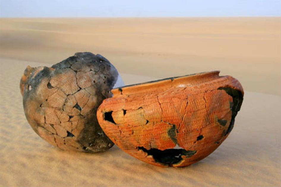
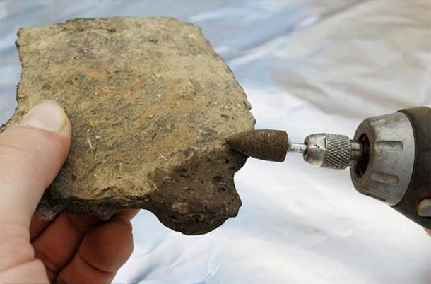

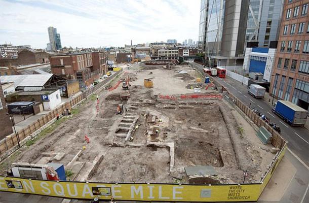
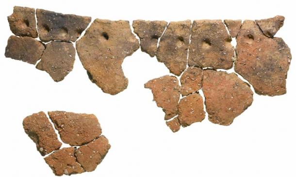


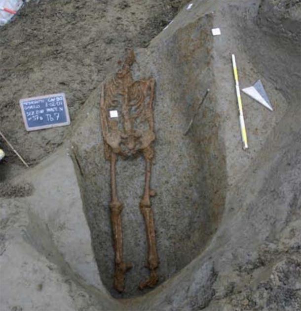
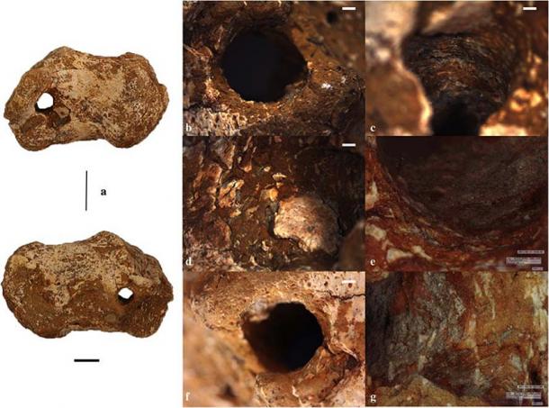
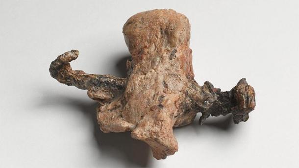

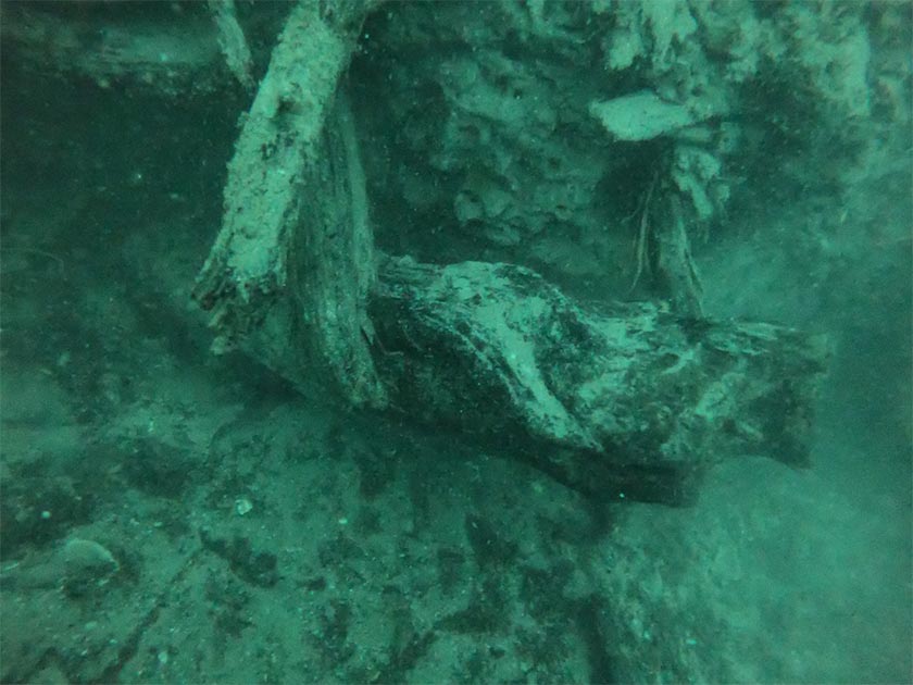
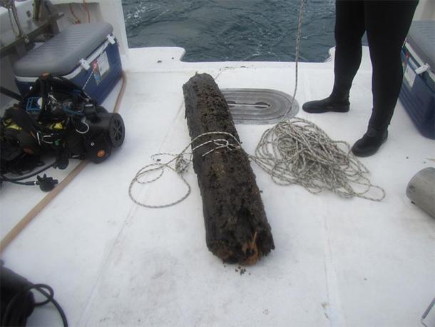
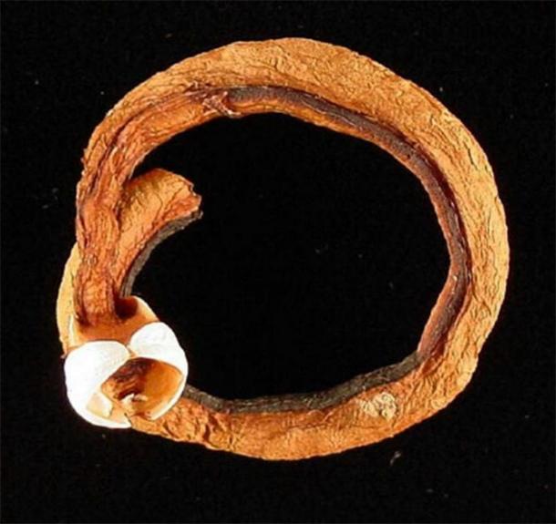
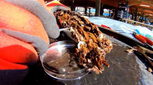

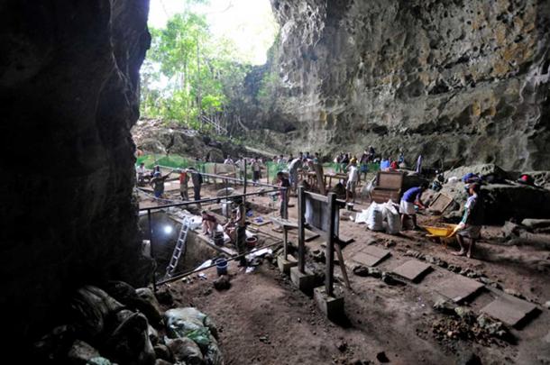
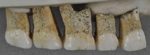
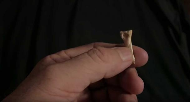
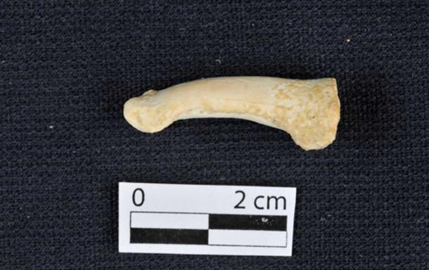
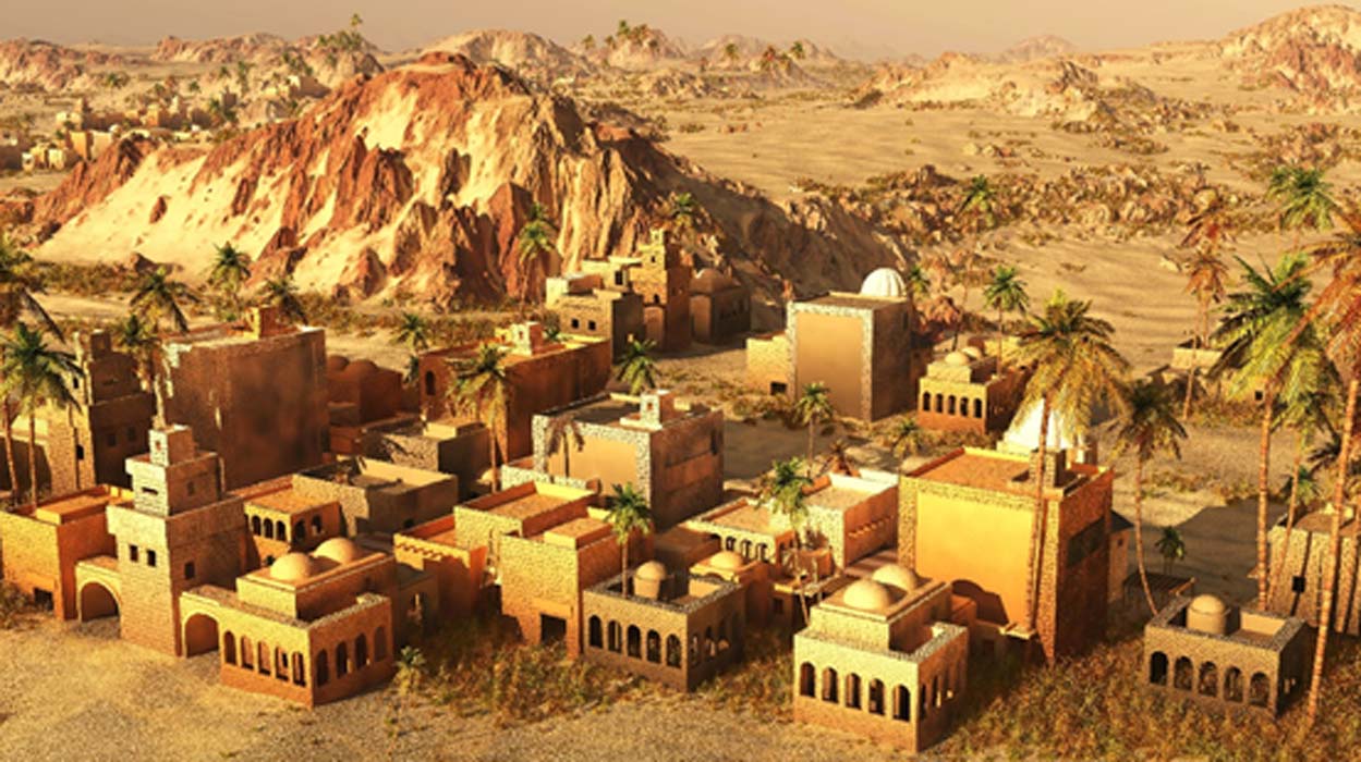
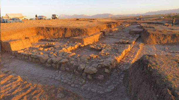

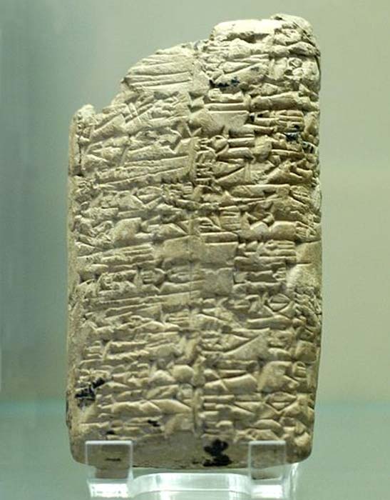

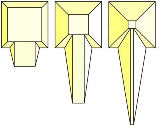
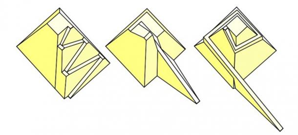
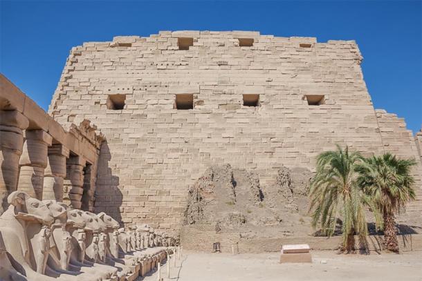

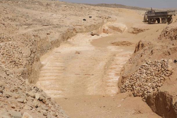
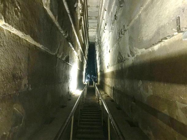
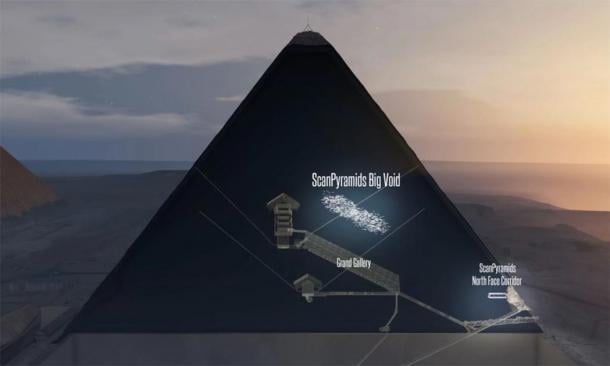
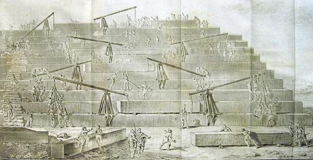
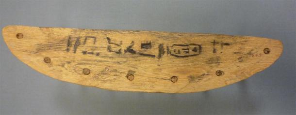
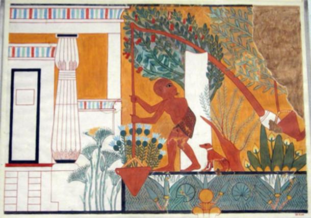
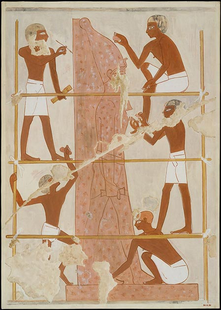
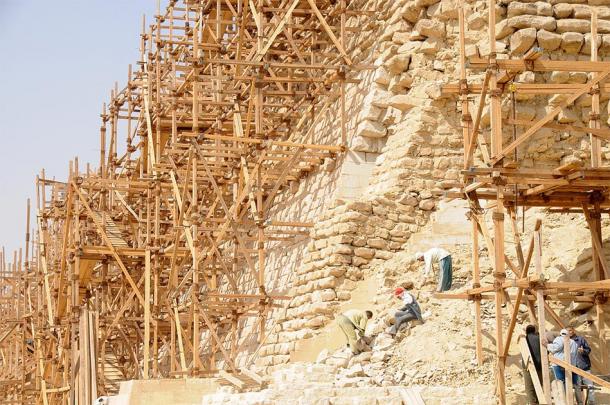


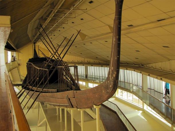
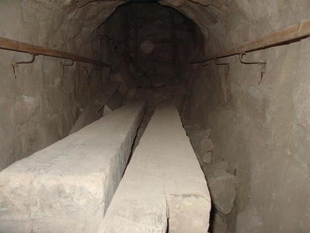


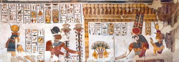
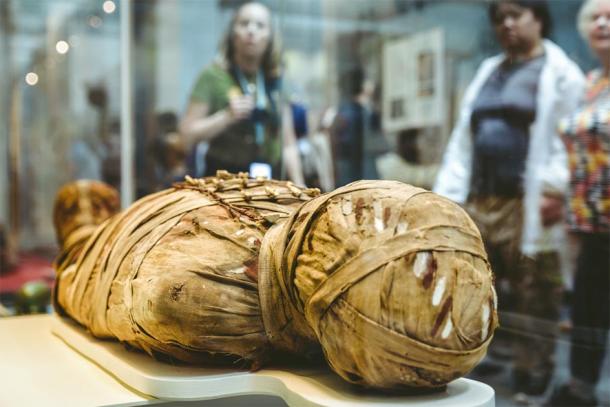
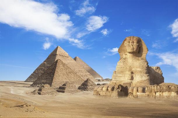
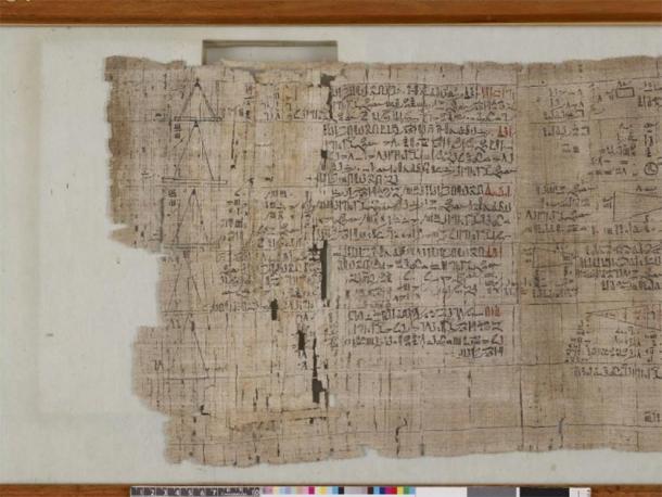
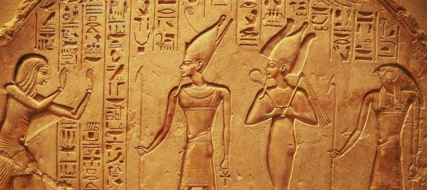

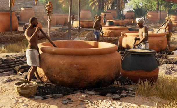
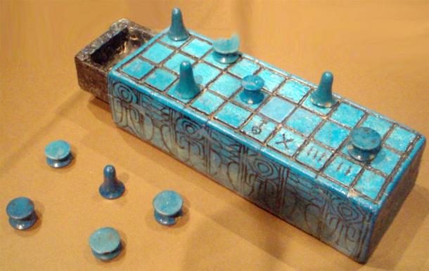
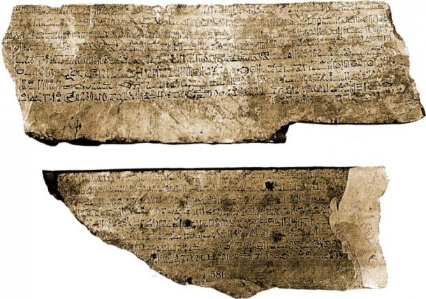


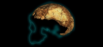
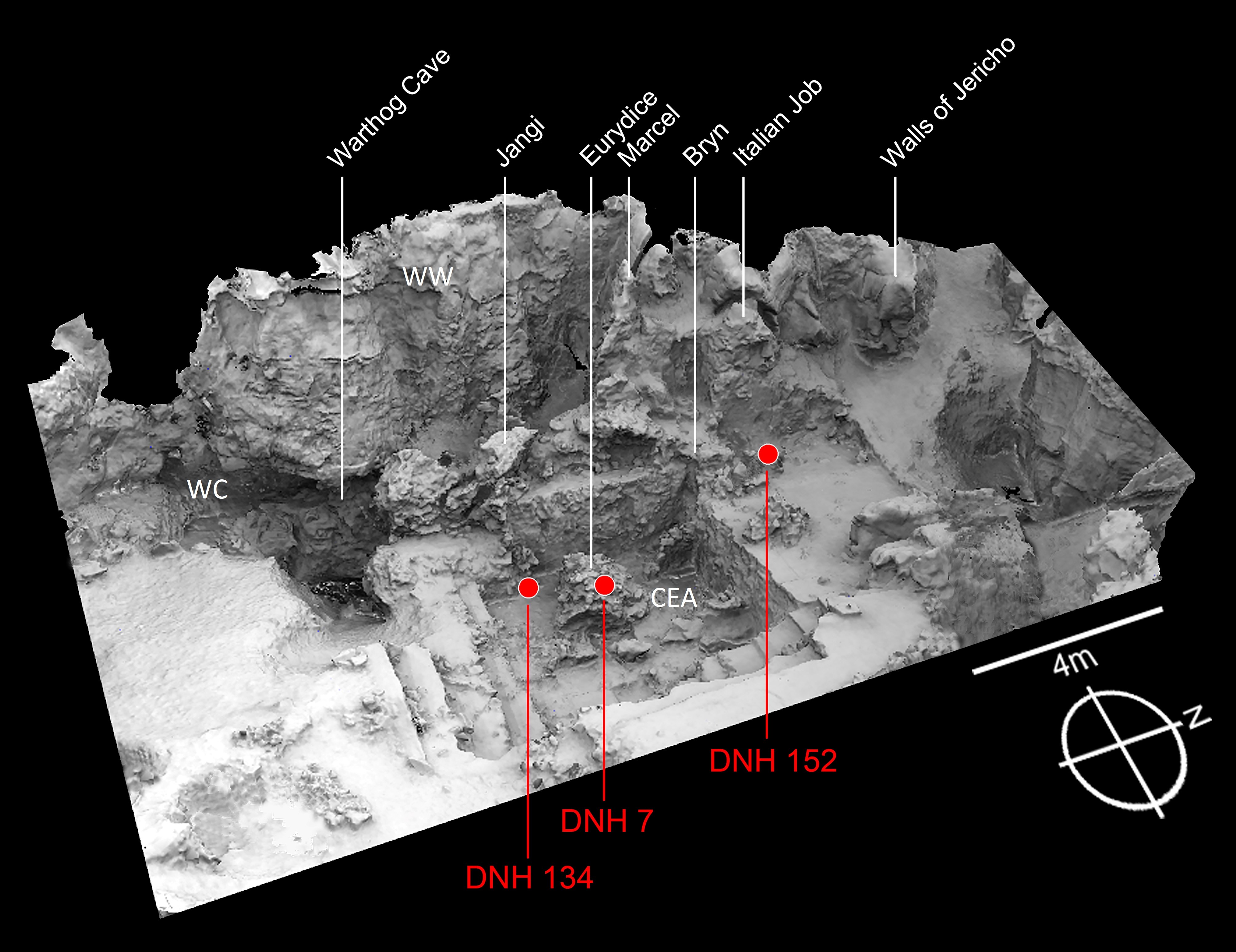
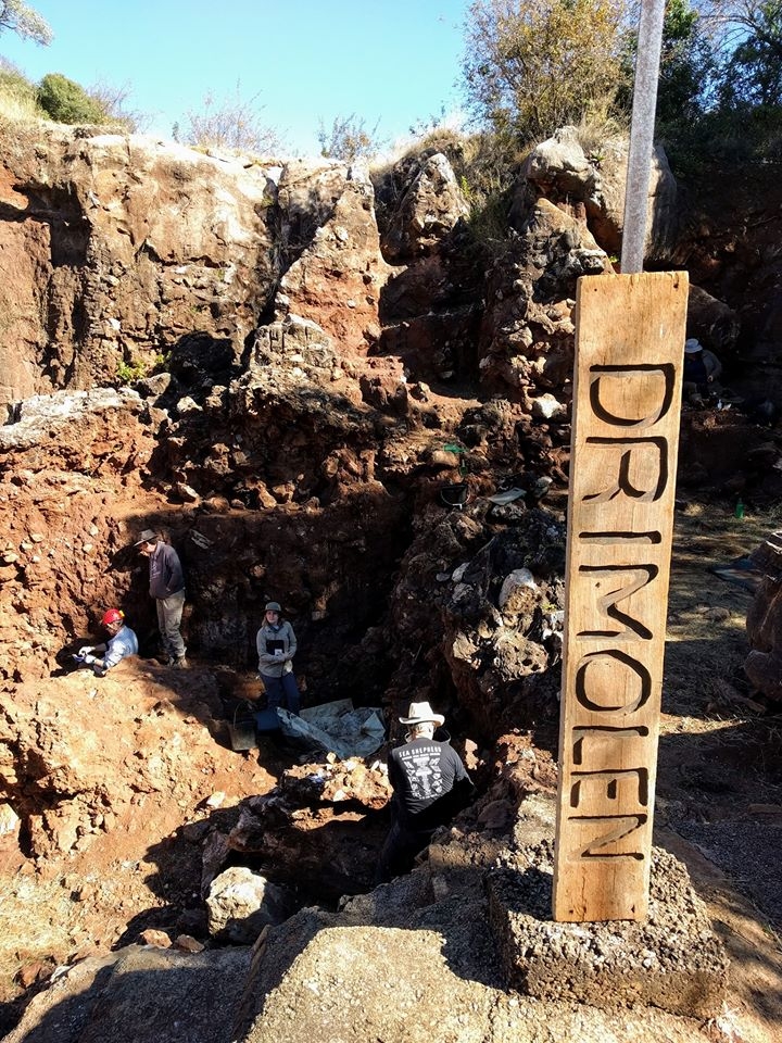


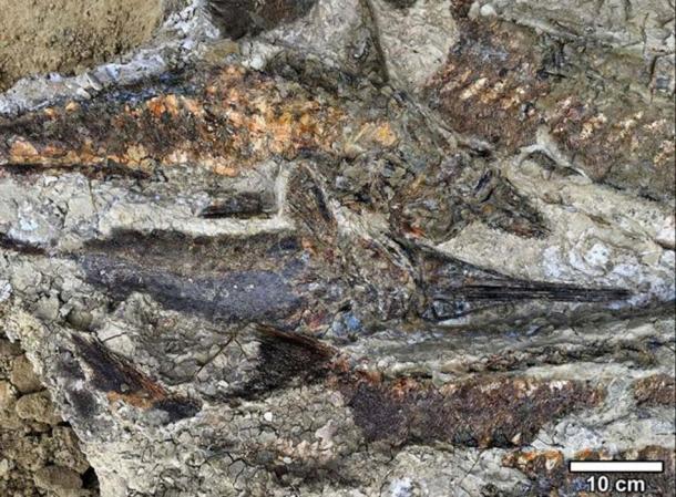
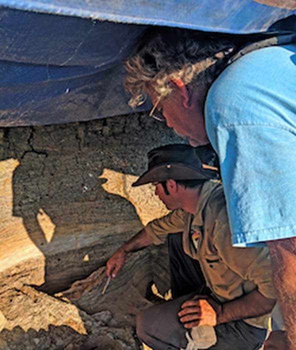

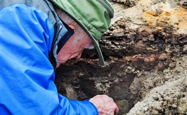

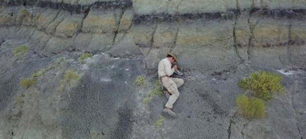


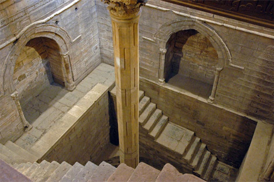
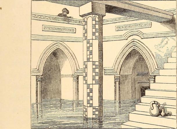

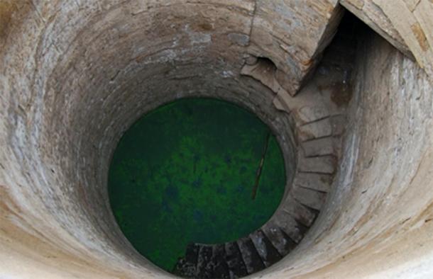
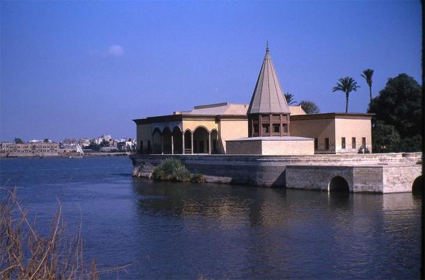
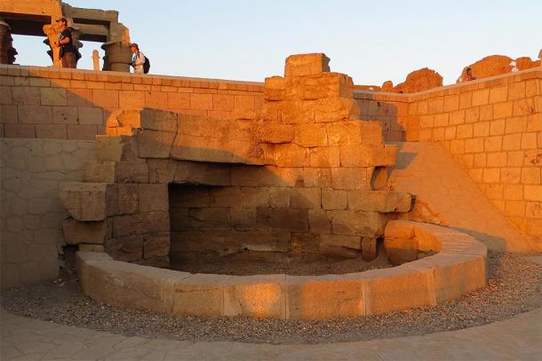
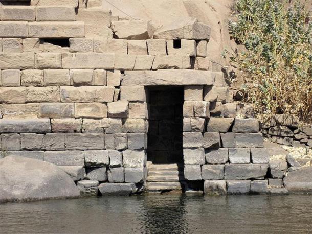


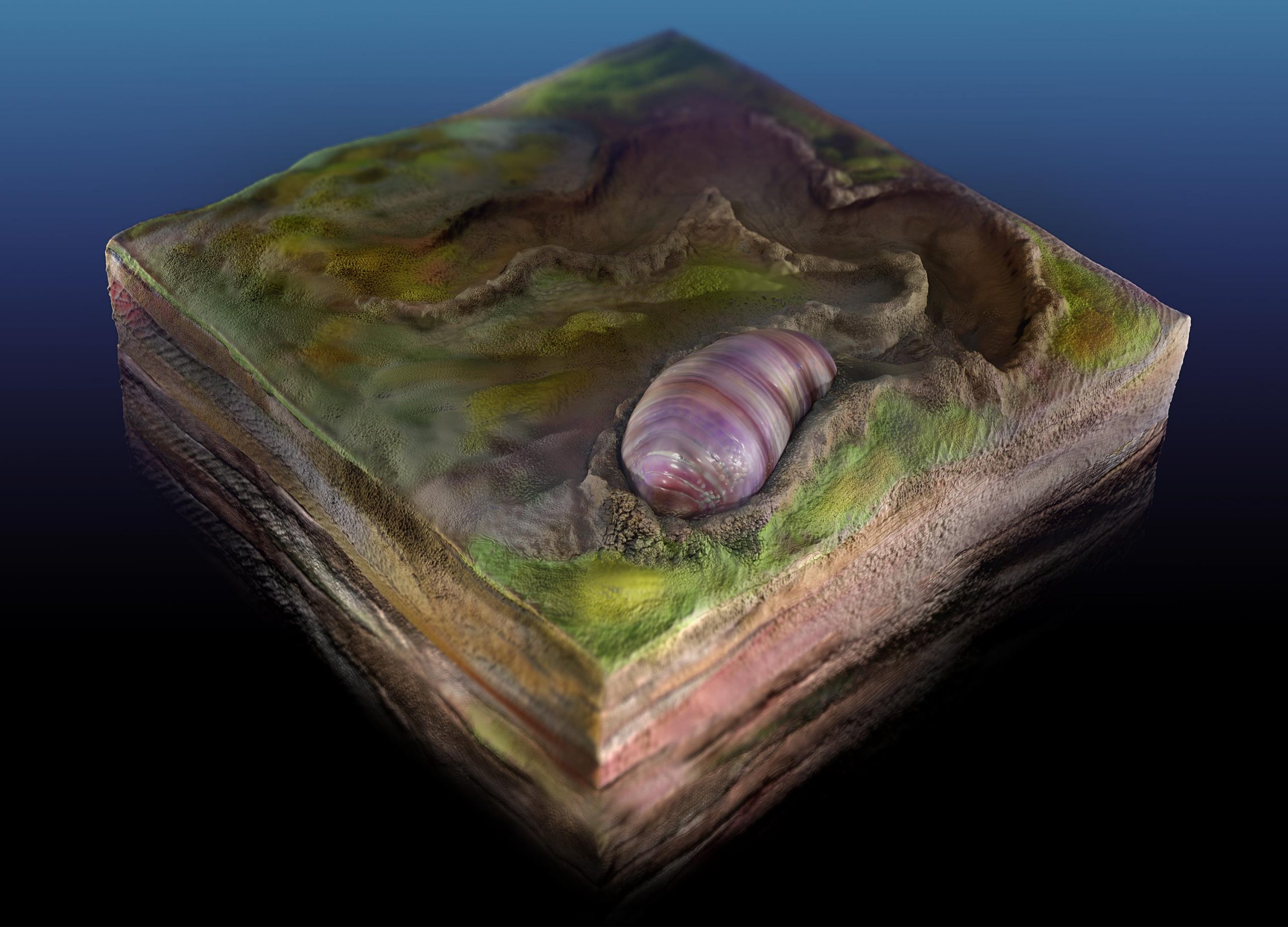

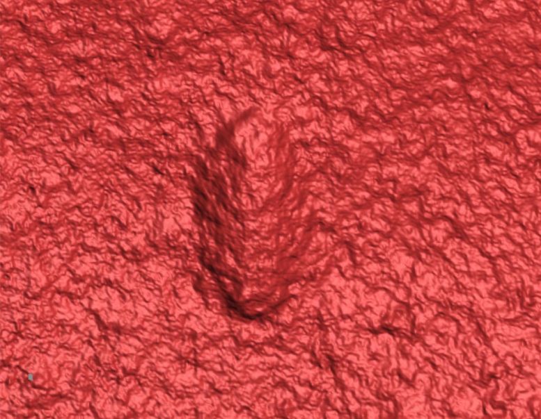


