The purpose of this blog is the creation of an open, international, independent and free forum, where every UFO-researcher can publish the results of his/her research. The languagues, used for this blog, are Dutch, English and French.You can find the articles of a collegue by selecting his category. Each author stays resposable for the continue of his articles. As blogmaster I have the right to refuse an addition or an article, when it attacks other collegues or UFO-groupes.
Druk op onderstaande knop om te reageren in mijn forum
Zoeken in blog
Deze blog is opgedragen aan mijn overleden echtgenote Lucienne.
In 2012 verloor ze haar moedige strijd tegen kanker!
In 2011 startte ik deze blog, omdat ik niet mocht stoppen met mijn UFO-onderzoek.
BEDANKT!!!
Een interessant adres?
UFO'S of UAP'S, ASTRONOMIE, RUIMTEVAART, ARCHEOLOGIE, OUDHEIDKUNDE, SF-SNUFJES EN ANDERE ESOTERISCHE WETENSCHAPPEN - DE ALLERLAATSTE NIEUWTJES
UFO's of UAP'S in België en de rest van de wereld Ontdek de Fascinerende Wereld van UFO's en UAP's: Jouw Bron voor Onthullende Informatie!
Ben jij ook gefascineerd door het onbekende? Wil je meer weten over UFO's en UAP's, niet alleen in België, maar over de hele wereld? Dan ben je op de juiste plek!
België: Het Kloppend Hart van UFO-onderzoek
In België is BUFON (Belgisch UFO-Netwerk) dé autoriteit op het gebied van UFO-onderzoek. Voor betrouwbare en objectieve informatie over deze intrigerende fenomenen, bezoek je zeker onze Facebook-pagina en deze blog. Maar dat is nog niet alles! Ontdek ook het Belgisch UFO-meldpunt en Caelestia, twee organisaties die diepgaand onderzoek verrichten, al zijn ze soms kritisch of sceptisch.
Nederland: Een Schat aan Informatie
Voor onze Nederlandse buren is er de schitterende website www.ufowijzer.nl, beheerd door Paul Harmans. Deze site biedt een schat aan informatie en artikelen die je niet wilt missen!
Internationaal: MUFON - De Wereldwijde Autoriteit
Neem ook een kijkje bij MUFON (Mutual UFO Network Inc.), een gerenommeerde Amerikaanse UFO-vereniging met afdelingen in de VS en wereldwijd. MUFON is toegewijd aan de wetenschappelijke en analytische studie van het UFO-fenomeen, en hun maandelijkse tijdschrift, The MUFON UFO-Journal, is een must-read voor elke UFO-enthousiasteling. Bezoek hun website op www.mufon.com voor meer informatie.
Samenwerking en Toekomstvisie
Sinds 1 februari 2020 is Pieter niet alleen ex-president van BUFON, maar ook de voormalige nationale directeur van MUFON in Vlaanderen en Nederland. Dit creëert een sterke samenwerking met de Franse MUFON Reseau MUFON/EUROP, wat ons in staat stelt om nog meer waardevolle inzichten te delen.
Let op: Nepprofielen en Nieuwe Groeperingen
Pas op voor een nieuwe groepering die zich ook BUFON noemt, maar geen enkele connectie heeft met onze gevestigde organisatie. Hoewel zij de naam geregistreerd hebben, kunnen ze het rijke verleden en de expertise van onze groep niet evenaren. We wensen hen veel succes, maar we blijven de autoriteit in UFO-onderzoek!
Blijf Op De Hoogte!
Wil jij de laatste nieuwtjes over UFO's, ruimtevaart, archeologie, en meer? Volg ons dan en duik samen met ons in de fascinerende wereld van het onbekende! Sluit je aan bij de gemeenschap van nieuwsgierige geesten die net als jij verlangen naar antwoorden en avonturen in de sterren!
Heb je vragen of wil je meer weten? Aarzel dan niet om contact met ons op te nemen! Samen ontrafelen we het mysterie van de lucht en daarbuiten.
09-02-2025
Could This Simple Chemical Test Unlock the Mystery of Life on Mars?
Could This Simple Chemical Test Unlock the Mystery of Life on Mars?
The search for life beyond Earth has long focused on detecting biosignatures—chemical traces of biological activity.
Scientists are pioneering a new approach to detecting extraterrestrial life by leveraging chemotaxis—a natural phenomenon where organisms move toward specific chemicals. This breakthrough could significantly enhance the search for microbial life on Mars and beyond.
A New Strategy for Finding Life on Other Worlds
The search for life beyond Earth has long focused on detecting biosignatures—chemical traces of biological activity. However, a German research team has introduced a potentially game-changing method: rather than simply looking for traces of life, why not trigger living organisms to reveal themselves?
Led by Max Riekeles of the Technical University of Berlin, the team developed a novel approach using L-serine, an amino acid known to stimulate movement in microorganisms. If extraterrestrial microbes exist on Mars, this method could make them more detectable.
“Our astrobiology research group is highly interdisciplinary, comprising biologists, aerospace engineers, medical engineers, chemists, geologists, and physicists,” Riekeles explained. “We often hold collaborative discussions to bring together diverse perspectives and brainstorm innovative solutions.”
Why L-Serine Could Be Key to Detecting Martian Microbes
L-serine is not just another amino acid—it has cosmic significance. Scientists have detected it in meteorites and on the asteroid Ryugu, suggesting that it has existed since before the formation of the Solar System. Since both Earth and Mars were bombarded by carbon-rich asteroids in their early history, it’s reasonable to assume L-serine is present on Mars as well.
“If life developed on Mars with a similar biochemistry to known life on Earth, it seems plausible that L-serine could also be a potent chemoattractant for hypothetical Martian microbes,” Riekes continued. “Additionally, the environmental conditions of early Mars, which were warmer and likely supported liquid water, resemble those of early Earth, making a similar biochemistry of putative Martian microbes plausible.”
To test this hypothesis, the researchers studied extremophiles—microbes that thrive in extreme environments similar to those found on Mars. They selected three species:
Bacillus subtilis spores, capable of surviving extreme heat up to 100°C.
Pseudoalteromonas haloplanktis, found in Antarctica and adapted to temperatures as low as -2.5°C.
Haloferax volcanii, an archaeon that thrives in highly saline conditions, resembling environments that could exist on Mars.
Each of these microorganisms responded to L-serine by actively moving toward it, confirming its effectiveness in stimulating microbial motion.
A Simple, Space-Ready Life Detection Device
The team designed a minimalist, easy-to-use detection system that could be adapted for planetary missions. Their device consists of two chambers—one containing a microbial sample and the other filled with L-serine—separated by a thin membrane. If microbes are present and motile, they will swim toward the amino acid, providing a clear signal of life.
However, refining this device for real-world deployment poses additional challenges. Space missions require ultra-compact, resilient, and automated equipment. The researchers are now working to make their apparatus smaller, sturdier, and capable of functioning autonomously in space.
Beyond Mars: Expanding the Search for Life
While Mars remains the primary target, this technology could be used on other celestial bodies suspected to harbor life. Europa, one of Jupiter’s moons, has a subsurface ocean beneath its icy crust, making it an ideal candidate for this type of microbial detection.
The Berlin-based team is also exploring applications beyond space exploration. Similar technology could be adapted for water quality testing on Earth, offering new ways to detect microbial contamination in drinking water and environmental monitoring.
“We are continuing to develop the device to improve its Technology Readiness Level,” Riekeles said. “Our focus is on making it smaller, more robust, and fully automated to meet the requirements of space exploration. While we are driving the development process internally, we plan to collaborate with third parties, like space agencies, to ensure it becomes flight-ready.”
RELATED VIDEOS
Mars: Life on the Red Planet | BBC Earth Science
NASA's Perseverance Rover Discovers Signs of Past Life on Mars
NASA’s Revolutionary LISTER Mission Could Unlock the Moon’s Secrets
NASA’s Revolutionary LISTER Mission Could Unlock the Moon’s Secrets
LISTER aims to change that. By measuring the Moon’s internal heat flow, scientists can reconstruct its thermal history—shedding light on how the celestial body evolved over billions of years.
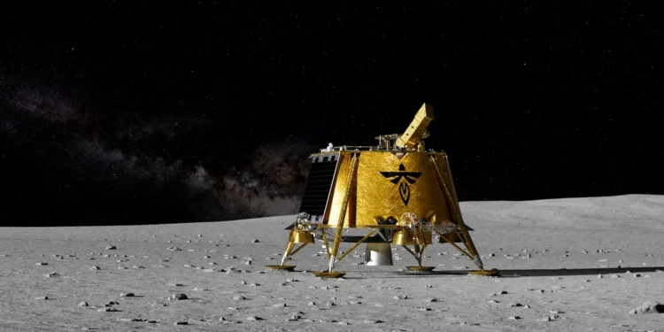
An illustration of the Blue Ghost Lander on the surface of the Moon.
Credit: Firefly Aerospace.
The race to explore the Moon has intensified, with multiple missions pushing the boundaries of human knowledge. Among these is NASA’s groundbreaking LISTER (Lunar Instrumentation for Subsurface Thermal Exploration with Rapidity), which could provide critical insights into the Moon’s origins and pave the way for sustainable lunar habitats.
Carried aboard Firefly Aerospace’s Blue Ghost lunar lander, LISTER launched aboard a SpaceX Falcon 9 rocket on January 15. As Blue Ghost journeys toward the Moon, scientists eagerly anticipate the instrument’s role in unraveling mysteries beneath the lunar surface.
Why LISTER Matters: The Hunt for the Moon’s True Origins
Despite decades of research, the Moon’s formation remains a puzzle. A leading theory suggests that billions of years ago, a Mars-sized object called Theia collided with Earth, ejecting debris that coalesced into the Moon. However, no single hypothesis fully explains the lunar body’s composition and characteristics.
LISTER aims to change that. By measuring the Moon’s internal heat flow, scientists can reconstruct its thermal history—shedding light on how the celestial body evolved over billions of years. Understanding these processes is crucial not only for planetary science but also for future space exploration.
Unlike previous instruments, LISTER features an advanced pneumatic drill designed to reach depths of three meters with minimal energy consumption. As it burrows into the Moon’s regolith, the instrument will take precise measurements of:
Thermal gradient: How temperature changes with depth
Thermal conductivity: How efficiently heat moves through lunar soil
These findings will help determine the Moon’s geological stability—a key factor in planning long-term lunar settlements.
The Lunar South Pole: The Next Frontier for Human Spaceflight
LISTER’s insights could play a vital role in NASA’s Artemis program, which aims to establish a sustained human presence on the Moon. The Artemis III mission will land astronauts at the lunar south pole, a region believed to contain vast ice reserves. This frozen water could serve as a critical resource for future explorers, enabling everything from drinking water to rocket fuel production.
However, recent studies suggest that the lunar surface is not as stable as once believed. Gradual contraction of the Moon is causing surface warping, making some regions prone to landslides. By analyzing subsurface heat flow, LISTER may help identify safer landing sites and inform the construction of future lunar bases.
LISTER’s Impact on Solar System Exploration
But experts explain that LISTER is more than just a lunar tool. Lister is a technological leap for planetary exploration. If successful, its pneumatic drilling system could be deployed on missions to Mars and beyond, helping scientists investigate subsurface conditions on other celestial bodies.
With its advanced instrumentation and potential to reshape our understanding of the Moon, LISTER could become one of the most influential lunar experiments of the decade.
Lunar Trailblazer: The Pioneering Small Satellite to Investigate Water on the Moon - Bethany Ehlmann
The Moon's Secrets: Unveiling Its Strange Interior
The Moon has Two Grand Canyons, Carved in Minutes by an Asteroid Impact
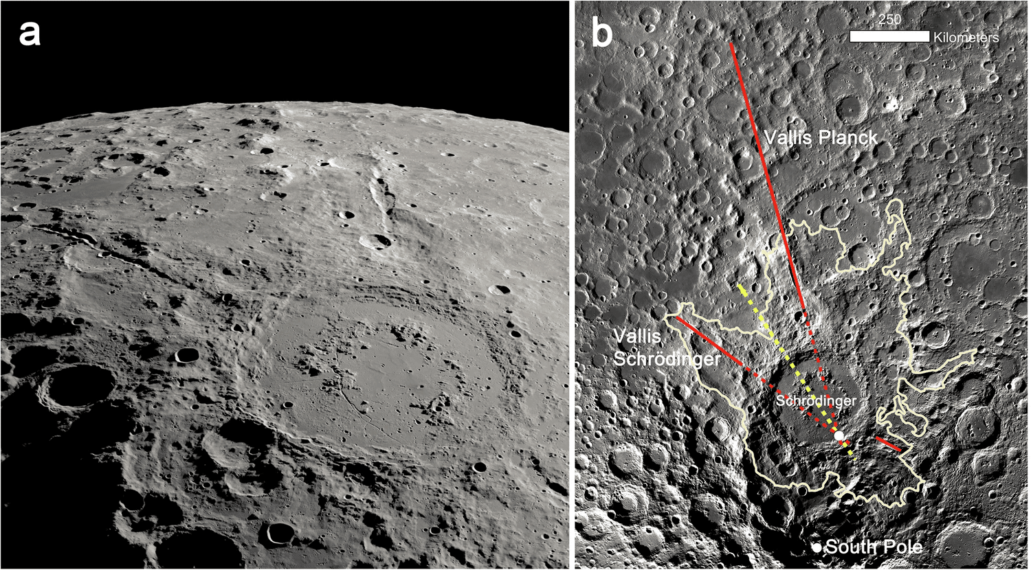
Artistic rendering of astronauts standing on the edge of the Vallis Schrödinger canyon. It extends out from the Schrödinger impact basin. Credit: Lunar and Planetary Institute/Michael Carroll.
The Moon has Two Grand Canyons, Carved in Minutes by an Asteroid Impact
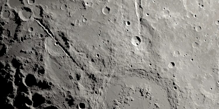
Our Moon continues to surprise us with amazing features. Scientists recently shared new information about two canyons that branch out from a major lunar impact. The site is the Schrödinger basin near the Moon’s South Pole. It formed when an asteroid or possibly even a leftover planetesimal slammed into the surface. It took only minutes to dig out that huge crater and split the landscape to make two huge rifts that extend from the site.
According to David Kring of the Lunar and Planetary Institute in Houston, TX, the impact is of very ancient origin. “Nearly four billion years ago,” he said, “an asteroid or comet flew over the lunar south pole, brushed by the mountain summits of Malapert and Mouton, and hit the lunar surface. The impact ejected high-energy streams of rock that carved two canyons that rival the size of Earth’s Grand Canyon. While the Grand Canyon took millions of years to form, the two grand canyons on the Moon were carved in less than 10 minutes.”
Those two canyons—named Vallis Schrödinger and Vallis Planck—are significant clues to that turbulent time in the Moon’s past. And, they’re impressive. Vallis Schrödinger is just under 300 kilometers long, 20 km wide, and 2.7 kilometers deep. Vallis Planck has two units. One is a deep canyon within the ejecta blanket of debris thrown out by the impact. The rest comprises a row of craters made as falling rocks were thrown out from the impact. They fell back to the Moon to create so-called “secondary craters.” The canyon part is about 280 kilometers deep, 27 km wide, and 3.5 km deep. The depth of both of these canyons surpasses the deep gorges of Earth’s Grand Canyon in Arizona.
Anatomy of an Impact and its Aftermath
The impactor probably slammed into the surface at nearly 55,000 kilometers per hour. The crash is what produced the enormous 320-kilometer-diameter Schrödinger impact basin. In the aftermath, the rocky debris scoured the deep canyons.
Schrödinger formed in the outer margin of the South Pole-Aitken (SPA) basin. At a diameter of about 2,400 km, it’s the largest and oldest impact basin on the Moon. The basin’s rim is about 300 km from the South Pole and within 125 km of the proposed exploration site for the Artemis mission.
The Schrödinger crater has a ~150-km diameter peak ring and the whole area is surrounded by a blanket of impact ejecta that splashed out in an irregular pattern up to 500 km away. The outermost crater ring resembles a circular mountain range and rises 1 to 2.5 km above the basin floor. It was produced by the collapse of a central uplift after the impact. After the impact, basaltic lava flows flooded the area. A large pyroclastic vent erupted more material onto the basin floor. That volcanic activity ended around 3.7 billion years ago.
Impact Anomalies
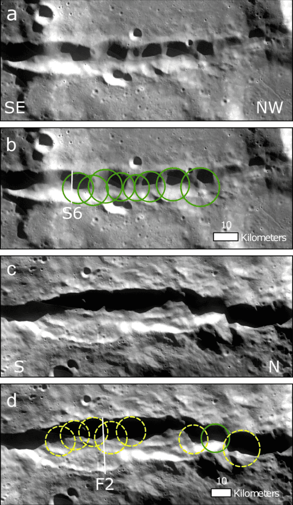
A careful analysis of the impact basin the canyons, and the ejecta surrounding the site by Kring and a team of scientists at the Lunar Planetary Laboratory, gives an idea of impact details. In a paper released about the site, the scientists discuss its features, plus some unusual finds. For example, the canyon rays don’t converge at the basin’s center as you might expect from typical impacts. They seem to come together in a different spot. That implies a point explosion impact.
Schrödinger peak-ring impact basin and two radiating canyons carved by impact ejecta. NASASVSErnest T. Wright. b Azimuthal Equidistant Projection of the Moon LRO LROC WAC Global Morphology Mosaic 100 centered on the Schrödinger basin, with the continuous ejecta blanket outlined and radial secondary crater rays (red). Vallis Schrödinger and Vallis Planck intersect near the southern rim of the basin (white point). The size of the point indicates the uncertainty. The projected bearing of the primary impactor (yellow) runs through the point of intersection and the basin center. A third unnamed feature extends in an uprange direction.
The location of the converging rays suggests that the incoming asteroid’s trajectory was about 33.5 west of north. The evidence also points to a distributed impact. That could mean the impactor came in at a low angle. Or, it’s also possible that secondary ejecta from the impact also came in at low angles. There are many secondary craters in the area which help explain the possibilities. Continued analysis will help explain the huge amounts of energy released in the event. Gareth Collins, one of Kring’s team members, said, “The Schrödinger crater is similar in many regards to the dino-killing Chicxulub crater on Earth. By showing how Schrödinger’s km-deep canyons formed, this work has helped to illuminate how energetic the ejecta from these impacts can be.”
Future Exploration
Of course, these rays and the impact basin will end up as great exploration points for NASA’s upcoming Artemis missions. Right now, the evidence from the ejecta blanket points to the fact that there’s an uneven distribution, particularly in the area where the first missions are planned. That will allow astronauts and robotic probes to reach underlying samples of the Moon’s primordial crust without having to dig through rocks of a younger age.
Since the basin is the second-youngest basin on the Moon, the impact melted rocks will be a great way to test the actual age of the impact. The general understanding is that some 3.8 billion years ago, the Moon (and Earth) experienced a great many of these collisions. This epoch was the Late Heavy Bombardment, thought to have lasted up to 200 million years. The continual impacts during this time scarred the surfaces of the rocky planets and the Moon, as well as asteroids. Lunar rocks created as a result of lava flows at that time will open a window into their ages and mineralogy, especially compared to other, older rock formations. They should also improve our understanding of that period of solar system history. In particular, it can help scientists characterize the impacts on Earth that affected not just the surface, but its life forms.
Space Junk Could Re-Enter the Atmosphere in Busy Flight Areas
In the more than 60 years since the Space Age began, humans have sent more than 6,740 rockets to space. According to the ESA’s Space Debris Office, this has resulted in 56,450 objects in orbit; about 36,860 of these objects are regularly tracked and maintained in a catalog, while 10,200 are still functioning. The rest is a combination of spent rocket stages, defunct satellites, and pieces of debris caused by unused propellant exploding and orbital collisions. This is leading to a cascade effect known as Kessler Syndrome, where the amount of debris in orbit will lead to more collisions and more debris.
What’s worse, the situation is only projected to get worse since more launches are expected with every passing year. Last year, space agencies and commercial space companies conducted a record-breaking 263 launches, with the U.S. (158) and China (68) leading the way. And with future break-ups occurring at historic rates of 10 to 11 per year, the number of debris objects in orbit will continue to increase. According to a new study by a team from the University of British Columbia (UBC), this also means that debris falling to Earth will have a 1 in 4 chance per year of entering busy airspace.
Artist’s impression of the orbital debris problem. Credit: UC3M
Traditionally, the discussion of space junk and the Kessler Syndrome has focused on how debris in orbit will pose a hazard for future satellites, payloads, and current and future space stations. In 2030, NASA and its many partnered space agencies plan to decommission the International Space Station (ISS) after thirty years of continuous service. However, this situation will also mean that more debris will be deorbiting regularly, not all of which will completely burn up in Earth’s atmosphere.
An illustration of a field of orbital debris, or space junk, circling Earth.
While the chance of debris hitting an aircraft is very low (one in 430,000, according to their paper), the UBC team’s research highlights the potential for disruption to commercial air flights and the additional costs it will lead to. The situation of more launches and more hazards is illustrated perfectly by the “rapid unscheduled disassembly” (RUD) of the Starship on January 16th, during its seventh orbital flight test. The explosion, which happened shortly after the prototype reentered Earth’s atmosphere, caused debris to rain down on the residents of the Turks and Caicos. Said Wright in a UBC News release:
“The recent explosion of a SpaceX Starship shortly after launch demonstrated the challenges of having to suddenly close airspace. The authorities set up a ‘keep out’ zone for aircraft, many of which had to turn around or divert their flight path. And this was a situation where we had good information about where the rocket debris was likely to come down, which is not the case for uncontrolled debris re-entering the atmosphere from orbit.”
A similar situation happened in 2022 when the spent stages of a Chinese Long March 5B (CZ-5B) weighing about 20 metric tons (22 U.S. tons) prompted Spanish and French aviation authorities to close parts of their airspace. If spent stages and other payloads have a low enough orbit, they can reenter Earth’s orbit uncontrolled, and large portions may make it to the ground. In addition to the record number of launches last year, there were also 120 uncontrolled rocket debris re-entries while more than 2,300 spent rocket stages are still in orbit.
Debris from the SpaceX Starship launched on January 16th, spotted over the Turks and Caicos Islands. Credit: Marcus Haworth/Reuters
According to the International Air Transport Association, passenger numbers are expected to increase by almost 7% this year. With rocket launches and commercial flights increasing at their current rate, Wright and his colleagues say that action must be taken to mitigate the potential risks. As part of their study, the team selected the busiest day and location for air traffic in 2023, which was in the skies above Denver, Colorado – with one aircraft for every 18 square km (~7 mi2). They then paired this to the probability of spent rock stages reentering Earth’s atmosphere (based on a decade of data) above the flights.
With this as their peak, they calculated the probability of rocket debris reentering the atmosphere over different air traffic density thresholds. Their results showed that for regions experiencing 10% peak air traffic density or higher, there was a 26% chance of deorbited rocket debris entering that airspace. “Notably, the airspace over southern Europe that was closed in 2022 is only five percent of the peak,” said Wright. “Around the world, there is a 75-per-cent chance of a re-entry in such regions each year.”
At present, whenever orbital debris reenters the atmosphere around busy airspace, aviation authorities will respond by diverting flight paths, closing airspace, or taking the risk of allowing flights to continue. “But why should authorities have to make these decisions in the first place? Uncontrolled rocket body re-entries are a design choice, not a necessity,” said Dr. Boley. “The space industry is effectively exporting its risk to airlines and passengers.”
One possibility is to design rocket stages to reenter the atmosphere in a controlled way so they can crash into the ocean far away from busy air traffic lanes. However, this solution requires collective international action. “Countries and companies that launch satellites won’t spend the money to improve their rocket designs unless all of them are required to do so,” said Dr. Byers. “So, we need governments to come together and adopt some new standards here.”
During their stints on the International Space Station (ISS) - lasting for months at a time - astronauts spend their spare time doing many of the same things people do on Earth.
This raises the question: do astronauts masturbate or have sex in zero-gravity?
NASA has not issued any strict guidelines around 'alone time', although commanders have stated that they do not allow sexual intercourse on the ISS.
Now, two scientists have revealed what would happen if an astronaut ejaculated in space.
Sex historian, Dr Esme Louise James, and AI expert, Dr Matt Agnew, turned to the concept of conservation of momentum to understand what would happen if a 'man's rocket blasted off in space'.
According to the pair's calculations, ejaculation would propel the astronaut backwards at a speed of around two metres/hour.
This could throw a spanner in the works for astronauts hoping to get frisky on future missions to Mars.
Dr Adam Watkins, Associate Professor in reproductive and developmental physiology, at the University of Nottingham previously told MailOnline: 'Sex in space is physically possible, but would not be as easy as it is here on Earth.'
Sex historian, Dr Esme Louise James, and AI expert, Dr Matt Agnew , turned to the concept of conservation of momentum to understand what would happen if a 'man's rocket blasted off in space'
Dr James and Dr Agnew posted a video on TikTok, exploring what would happen if a male astronaut ejaculated in space.
'I'm here with Matt Agnew to finally answer the question we're sure has also plagued your mind for many years,' Dr James wrote in the video's caption.
To work it out, the pair used a fundamental concept of physics known as the 'conservation of momentum'.
Dr Agnew explained: 'The conservation of momentum says that the total momentum of two or more bodies in a system will remain the same.
'This means that the mass multiplied by the velocity of the ejaculate will equal the mass multiplied by the velocity of the man.'
The pair estimate that the average volume of ejaculate would be around one teaspoon, while its density would be around one gram per millilitre.
Meanwhile, the average speed of ejaculation is an impressive 45km/hr (27mph), according to the scientists.
'We multiply the mass by velocity, and that gives us the momentum of the ejaculate,' Dr Agnew said.
No human has ever officially had sex in space (that they've admitted to...), and the lack of gravity could make it difficult
Could you have sex in space?
Sex in space is physically possible but not recommended.
There is nothing stopping astronauts from overcoming the challenges of having sex in microgravity.
However, low libido and erectile dysfunction may make things difficult.
The biggest risks are associated with pregnancy. Experts are not sure whether microgravity and radiation will damage a developing foetus.
Studies have suggested that developing in space could lead to birth defects in kids.
To conserve momentum and obey the fundamental laws of physics, the man's velocity multiplied by his mass must also equal this number.
'Let's say the average man weighs 70 kilos. This means the velocity must equal 0.000562 metres/second,' Dr Agnew explained.
In simple terms, this means the ejaculation would cause the astronaut to travel backwards at a speed of about two metres per hour.
'How fast is that? About the speed of an average garden snail,' Dr Agnew joked.
'So, if you ever find yourself in the vacuum of space, and you want to use ejaculate as propellant, you're not gonna be moving very quickly.'
The video has delighted many users, who flocked to the comments over on TikTok.
'These school math problems are getting insane,' one user joked.
Another added: 'Physics has never been put to better use than this,' while one joked: 'Why aren't they teaching this in school?'
No human has ever officially had sex in space (that they've admitted to...), and the lack of gravity could make it difficult.
German astronaut Ulrich Walter once suggested in an interview that humans could look to the animal kingdom for inspiration.
Dolphins will sometimes enlist the help of a third to push the couple together and prevent them from drifting apart while mating.
Mr Walter suggested that open-minded astronauts might also enlist the help of a willing friend to push them together.
Alternatively, Paul Root Wolpe, a former NASA Bioethicist, has described how the humble Velcro strap could be the answer.
Mr Wolpe told DW: 'Everything on the walls of the space station is covered in Velcro, so you could take advantage of that by velcroing one partner to the wall.
'You have to get creative in this space.'
RELATED VIDEOS
Sex in Space - Fan Questions | StarTalk
You Need To Know How Astronauts Poop In Space
Life, Love And Sex In Space | SPACETIME - SCIENCE SHOW
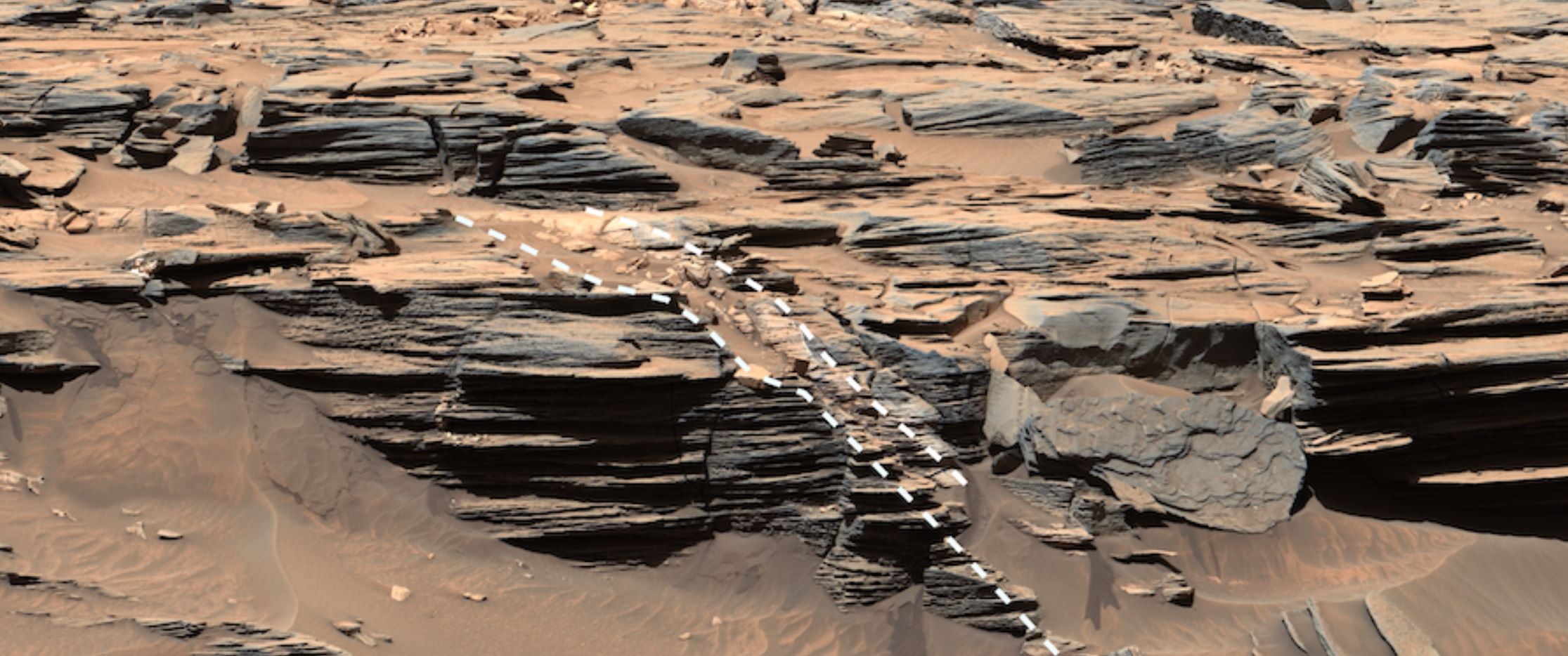
Among several recent findings, the rover has found rocks made of pure sulfur — a first on the Red Planet.
Scientists were stunned on May 30 when a rock that NASA’s Curiosity Mars rover drove over cracked open to reveal something never seen before on the Red Planet: yellow sulfur crystals.
Since October 2023, the rover has been exploring a region of Mars rich with sulfates, a kind of salt that contains sulfur and forms as water evaporates. But where past detections have been of sulfur-based minerals — in other words, a mix of sulfur and other materials — the rock Curiosity recently cracked open is made of elemental, or pure, sulfur. It isn’t clear what relationship, if any, the elemental sulfur has to other sulfur-based minerals in the area.
While people associate sulfur with the odor from rotten eggs (the result of hydrogen sulfide gas), elemental sulfur is odorless. It forms in only a narrow range of conditions that scientists haven’t associated with the history of this location. And Curiosity found a lot of it — an entire field of bright rocks that look similar to the one the rover crushed.
Pan around this 360-degree video to explore Gediz Vallis channel, the location where NASA’s Curiosity Mars rover discovered sulfur crystals and drilled its 41st rock sample. The images that make up this mosaic were captured by the rover’s MastCam in June. Credit: NASA/JPL-Caltech/MSSS
“Finding a field of stones made of pure sulfur is like finding an oasis in the desert,” said Curiosity’s project scientist, Ashwin Vasavada of NASA’s Jet Propulsion Laboratory in Southern California. “It shouldn’t be there, so now we have to explain it. Discovering strange and unexpected things is what makes planetary exploration so exciting.”
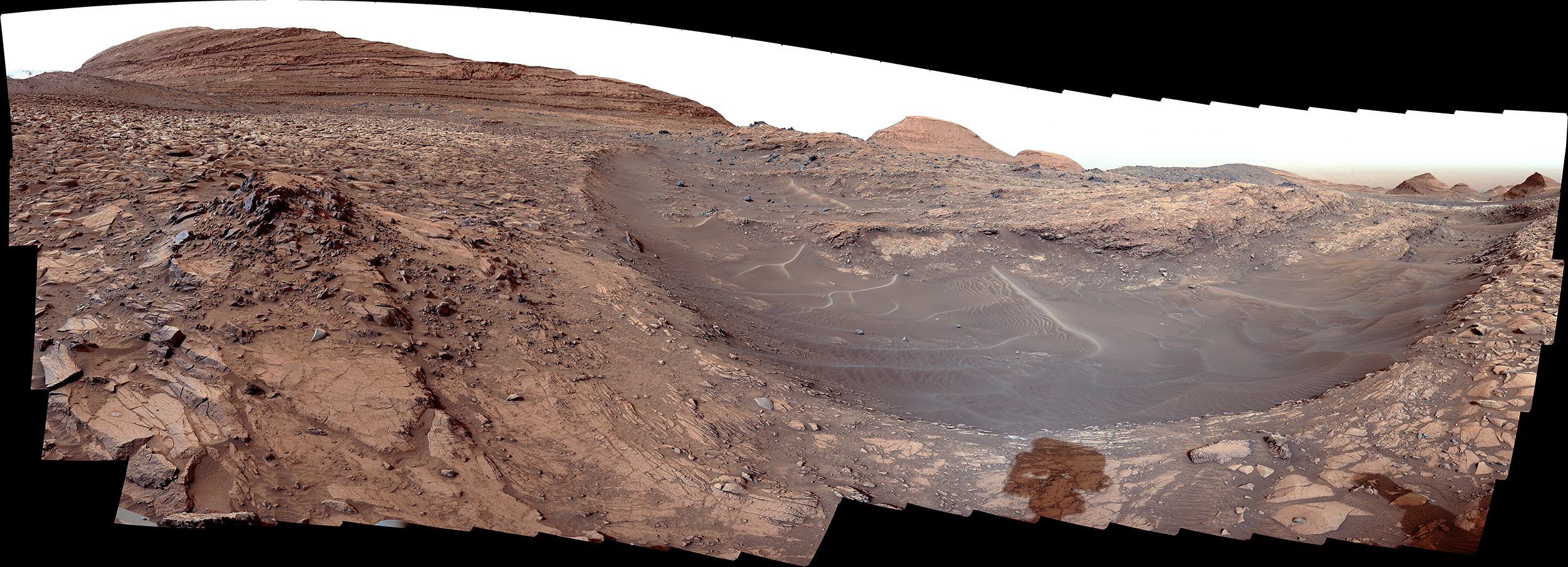
It’s one of several discoveries Curiosity has made while off-roading within Gediz Vallis channel, a groove that winds down part of the 3-mile-tall (5-kilometer-tall) Mount Sharp, the base of which the rover has been ascending since 2014. Each layer of the mountain represents a different period of Martian history. Curiosity’s mission is to study where and when the planet’s ancient terrain could have provided the nutrients needed for microbial life, if any ever formed on Mars.
NASA’s Curiosity Mars rover captured this view of Gediz Vallis channel on March 31. This area was likely formed by large floods of water and debris that piled jumbles of rocks into mounds within the channel.
NASA/JPL-Caltech/MSSS
Floods and Avalanches
Spotted from space years before Curiosity’s launch, Gediz Vallis channel is one of the primary reasons the science team wanted to visit this part of Mars. Scientists think that the channel was carved by flows of liquid water and debris that left a ridge of boulders and sediment extending 2 miles down the mountainside below the channel. The goal has been to develop a better understanding of how this landscape changed billions of years ago, and while recent clues have helped, there’s still much to learn from the dramatic landscape.
Since Curiosity’s arrival at the channel earlier this year, scientists have studied whether ancient floodwaters or landslides built up the large mounds of debris that rise up from the channel’s floor here. The latest clues from Curiosity suggest both played a role: some piles were likely left by violent flows of water and debris, while others appear to be the result of more local landslides.
While exploring Gediz Vallis channel in May, NASA’s Curiosity captured this image of rocks that show a pale color near their edges. These rings, also called halos, resemble markings seen on Earth when groundwater leaks into rocks along fractures, causing chemical reactions that change the color.
NASA/JPL-Caltech/MSSS
Those conclusions are based on rocks found in the debris mounds: Whereas stones carried by water flows become rounded like river rocks, some of the debris mounds are riddled with more angular rocks that may have been deposited by dry avalanches.
Finally, water soaked into all the material that settled here. Chemical reactions caused by the water bleached white “halo” shapes into some of the rocks. Erosion from wind and sand has revealed these halo shapes over time.
“This was not a quiet period on Mars,” said Becky Williams, a scientist with the Planetary Science Institute in Tucson, Arizona, and the deputy principal investigator of Curiosity’s Mast Camera, or Mastcam. “There was an exciting amount of activity here. We’re looking at multiple flows down the channel, including energetic floods and boulder-rich flows.”
A Hole in 41
All this evidence of water continues to tell a more complex story than the team’s early expectations, and they’ve been eager to take a rock sample from the channel in order to learn more. On June 18, they got their chance.
While the sulfur rocks were too small and brittle to be sampled with the drill, a large rock nicknamed “Mammoth Lakes” was spotted nearby. Rover engineers had to search for a part of the rock that would allow safe drilling and find a parking spot on the loose, sloping surface.
After Curiosity bored its 41st hole using the powerful drill at the end of the rover’s 7-foot (2-meter) robotic arm, the six-wheeled scientist trickled the powderized rock into instruments inside its belly for further analysis so that scientists can determine what materials the rock is made of.
Curiosity has since driven away from Mammoth Lakes and is now off to see what other surprises are waiting to be discovered within the channel.
More About the Mission
Curiosity was built by NASA’s Jet Propulsion Laboratory, which is managed by Caltech in Pasadena, California. JPL leads the mission on behalf of NASA’s Science Mission Directorate in Washington.
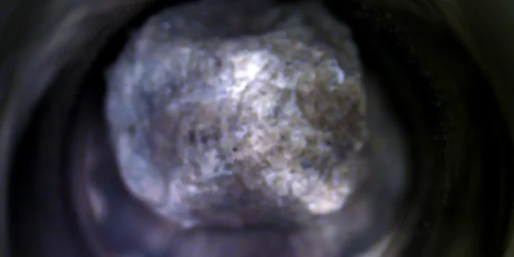
NASA Just Discovered the Oldest Martian Rock With a Texture Unlike Anything Ever Seen
NASA Just Discovered the Oldest Martian Rock With a Texture Unlike Anything Ever Seen
Adding to the excitement, Perseverance also detected serpentine minerals—a group of greenish rocks that likely formed when molten magma encountered water.
This small rock, dubbed "Silver Mountain" after the region where it was found, is officially the oldest sample ever collected by NASA's Perseverance rover.
Image Credit: NASA/JPL-Caltech
NASA’s Perseverance rover has just made an exciting breakthrough in its search for clues about Mars’ geological past, collecting a sample that scientists describe as “unlike anything we’ve seen before.” Named “Silver Mountain,” this newly acquired rock is the oldest sample ever collected on the Red Planet, dating back to the Noachian epoch—a period between 3.7 to 4.1 billion years ago when Mars was likely warmer and had liquid water.
A Mysterious Rock Unlike Any Other
The discovery was made in a scientifically intriguing region called Blue Hill, located within the larger Shallow Bay area of Jezero Crater. The site contains a unique variety of low-calcium pyroxene, a mineral found in many igneous rocks on Earth, particularly in the planet’s upper mantle. Scientists believe this mineral could provide new insights into Mars’ volcanic history and past water interactions.
Adding to the excitement, Perseverance also detected serpentine minerals—a group of greenish rocks that likely formed when molten magma encountered water. The presence of serpentine could hint at a history of hydrothermal activity, which is significant because such environments on Earth are known to support microbial life.
A Critical Find on a Limited Path
What makes this discovery even more significant is that Blue Hill is the only known outcrop of its kind along Perseverance’s current route. This means the opportunity to study its composition is limited. Recognizing its scientific value, mission controllers directed the rover to extract a 2.9-centimeter (1.1-inch) core sample, ensuring that a piece of this ancient Martian history would be preserved for further study.
The Mars Sample Return (MSR) mission aims to bring Perseverance’s collected samples back to Earth for detailed laboratory analysis. However, the mission has faced significant delays due to funding challenges and shifting priorities at NASA. With a new presidential administration on the horizon, the future of MSR is uncertain, raising concerns among planetary scientists eager to examine these invaluable specimens.
Despite these setbacks, Perseverance’s ongoing discoveries continue to deepen our understanding of Mars’ complex history.
RELATED VIDEO
Perseverance Rover Spots an Unusual Rock in Ancient River Channel (Mars Report)
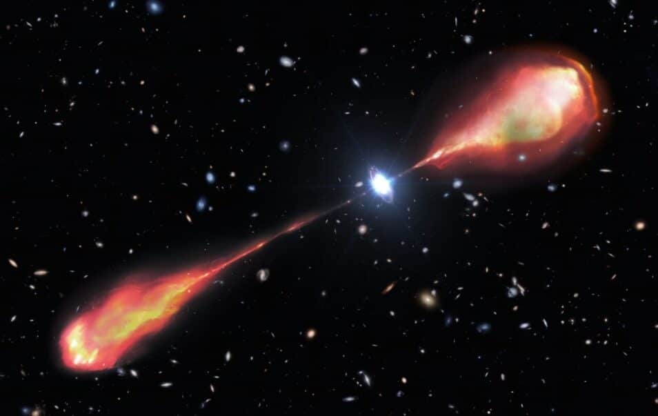
Deze gigantische jet, die zich over minstens 200.000 lichtjaar uitstrekt, ontstond toen het heelal nog geen 10 procent van zijn huidige leeftijd had.
Astronomen hebben met behulp van de Gemini North-telescoop – een van de twee telescopen van het International Gemini Observatory – de grootste radiojet ooit in het vroege heelal opgespoord. Tot nu toe bleven zulke grote radiojets grotendeels onzichtbaar in het verre heelal. Dankzij deze waarnemingen krijgen astronomen waardevolle nieuwe inzichten in wanneer de eerste jets ontstonden en hoe ze de evolutie van sterrenstelsels beïnvloedden.
Radiojets Uit decennia aan astronomische waarnemingen weten wetenschappers dat de meeste sterrenstelsels een superzwaar zwart gat in hun hart hebben. Wanneer gas en stof erin vallen, komt er door de wrijving enorm veel energie vrij, wat resulteert in heldere galactische kernen – quasars – die krachtige jets van energierijke materie de ruimte in schieten. Deze jets zijn met radiotelescopen over enorme afstanden te detecteren. In ons lokale heelal zijn zulke radiojets niet zeldzaam en worden ze in een handvol nabije sterrenstelsels gevonden. Maar in het verre, vroege heelal waren ze tot nu toe wel een zeldzaamheid.
Jacht Onderzoekers besloten echter de uitdaging aan te gaan en de jacht te openen op vroege radiojets. “We zochten naar quasars met krachtige radiojets in het vroege heelal, omdat dit ons inzicht geeft in hoe en wanneer de eerste jets werden gevormd en op welke manier ze de evolutie van sterrenstelsels hebben beïnvloed”, verklaart Anniek Gloudemans, postdoctoraal onderzoeker bij NOIRLab en hoofdauteur van de nieuwe studie.
Grootste ooit En nu komen ze met groot nieuws. In de nieuwe studie, gepubliceerd in The Astrophysical Journal Letters, onthullen ze namelijk de ontdekking van een verre radiojet met twee ‘lobben’, die zich uitstrekt over maar liefst 200.000 lichtjaar – twee keer zo breed als de Melkweg. Dit is de grootste radiojet die ooit zo vroeg in de geschiedenis van het heelal is gevonden.
De grootste radiojet ooit ontdekt in het vroege heelal, vastgelegd met behulp van verschillende telescopen, waaronder de LOFAR-telescoop, de Gemini North-telescoop en de Hobby Eberly Telescope. Dit beeld werd verder aangevuld met optische gegevens van de DECam Legacy Survey. Afbeelding: LOFAR/DECaLS/DESI Legacy Imaging Surveys/LBNL/DOE/CTIO/NOIRLab/NSF/AURA/F. Sweijen (Durham University)
De jet werd voor het eerst opgespoord met de internationale Low Frequency Array (LOFAR), een indrukwekkend netwerk van radiotelescopen verspreid over heel Europa. Vervolgwaarnemingen in het nabij-infrarood met de Gemini Near-Infrared Spectrograph (GNIRS) en in het optische bereik met de Hobby Eberly Telescope gaven een compleet beeld van de radiojet en de quasar die hem aandrijft. Deze ontdekkingen zijn essentieel voor een dieper begrip van het ontstaan en de processen achter de eerste grootschalige jets in ons heelal.
Om de eigenschappen van de quasar – zoals zijn massa en de snelheid waarmee hij materie opslokt – te achterhalen, onderzocht het team een specifieke lichtgolflengte die door quasars wordt uitgezonden: de MgII (magnesium) brede emissielijn. Dit signaal komt normaal gesproken in het ultraviolet voor, maar door de uitdijing van het heelal wordt het licht van de quasar ‘uitgerekt’ naar langere golflengten. Hierdoor bereikt het magnesiumsignaal de aarde in het nabij-infrarood, waar het met GNIRS kan worden gedetecteerd.
J1601+3102 De quasar, die de naam J1601+3102 heeft gekregen, ontstond toen het heelal nog geen 1,2 miljard jaar oud was – slechts 9 procent van zijn huidige leeftijd. Hoewel quasars soms massa’s hebben die miljarden keren groter zijn dan die van onze zon, is deze relatief klein en weegt hij ‘slechts’ 450 miljoen keer de massa van de zon. De dubbelzijdige jets vertonen een asymmetrie in zowel helderheid als lengte, wat suggereert dat een extreem omgevingseffect hen beïnvloedt.
Zwart gat De resultaten verschaffen interessante nieuwe inzichten in de vorming van krachtige radiostraling in het vroege heelal. “Opmerkelijk genoeg heeft de quasar die deze gigantische radiojet aandrijft geen extreem zwaar zwart gat, in vergelijking met andere quasars”, vertelt Gloudemans. “Dit suggereert dat een superzwaar zwart gat of een uitzonderlijk hoge accretiesnelheid niet per se
Ruis De eerdere schaarste aan grote radiojets in het vroege heelal werd vaak verklaard door de ruis van de kosmische microgolfachtergrond – de straling die is overgebleven van de oerknal. Deze achtergrondstraling dempt doorgaans het radiolicht van zulke verre objecten. “Maar omdat dit object zo extreem is, kunnen we het vanaf de aarde waarnemen, ondanks de enorme afstand”, legt Gloudemans uit. “Dit object toont aan wat we kunnen ontdekken door de krachten van verschillende telescopen, die op uiteenlopende golflengten werken, te bundelen.”
Wetenschappers hebben nog talloze vragen over hoe radiogheldere quasars zoals J1601+3102 zich onderscheiden van andere quasars. Het is bijvoorbeeld nog onduidelijk welke omstandigheden nodig zijn om zulke krachtige radiojets te creëren en wanneer de eerste radiojets in het heelal precies zijn ontstaan. Maar dankzij de combinatie van verschillende telescopen zijn astronomen nu in elk geval wel weer een stap dichter bij het begrijpen van deze mysterieuze kosmische fenomenen.
Avalanches, Icy Explosions, and Dunes: NASA Is Tracking New Year on Mars
Avalanches, Icy Explosions, and Dunes: NASA Is Tracking New Year on Mars
Instead of a winter wonderland, the Red Planet’s northern hemisphere goes through an active — even explosive — spring thaw.
It’s a new year on Mars, and while New Year’s means winter in Earth’s northern hemisphere, it’s the start of spring in the same region of the Red Planet. And that means ice is thawing, leading to all sorts of interesting things. JPL research scientist Serina Diniega explains.
Credit: NASA/JPL-Caltech
While New Year’s Eve is around the corner here on Earth, Mars scientists are ahead of the game: The Red Planet completed a trip around the Sun on Nov. 12, 2024, prompting a few researchers to raise a toast.
But the Martian year, which is 687 Earth days, ends in a very different way in the planet’s northern hemisphere than it does in Earth’s northern hemisphere: While winter’s kicking in here, spring is starting there. That means temperatures are rising and ice is thinning, leading to frost avalanches crashing down cliffsides, carbon dioxide gas exploding from the ground, and powerful winds helping reshape the north pole.
“Springtime on Earth has lots of trickling as water ice gradually melts. But on Mars, everything happens with a bang,” said Serina Diniega, who studies planetary surfaces at NASA’s Jet Propulsion Laboratory in Southern California.
Mars’ wispy atmosphere doesn’t allow liquids to pool on the surface, like on Earth. Instead of melting, ice sublimates, turning directly into a gas. The sudden transition in spring means a lot of violent changes as both water ice and carbon dioxide ice — dry ice, which is much more plentiful on Mars than frozen water — weaken and break.
“You get lots of cracks and explosions instead of melting,” Diniega said. “I imagine it gets really noisy.”
Using the cameras and other sensors aboard NASA’s Mars Reconnaissance Orbiter (MRO), which launched in 2005, scientists study all this activity to improve their understanding of the forces shaping the dynamic Martian surface. Here’s some of what they track.
Frost Avalanches
In 2015, MRO’s High-Resolution Imaging Science Experiment (HiRISE) camera captured a 66-foot-wide (20-meter-wide) chunk of carbon dioxide frost in freefall. Chance observations like this are reminders of just how different Mars is from Earth, Diniega said, especially in springtime, when these surface changes are most noticeable.
“We’re lucky we’ve had a spacecraft like MRO observing Mars for as long as it has,” Diniega said. “Watching for almost 20 years has let us catch dramatic moments like these avalanches.”
Martian spring involves lots of cracking ice, which led to this 66-foot-wide (20-meter-wide) chunk of carbon dioxide frost captured in freefall by the HiRISE camera aboard NASA’s Mars Reconnaissance Orbiter in 2015.
Credit: NASA/JPL-Caltech/Univ. of Arizona
Gas Geysers
Diniega has relied on HiRISE to study another quirk of Martian springtime: gas geysers that blast out of the surface, throwing out dark fans of sand and dust. These explosive jets form due to energetic sublimation of carbon dioxide ice. As sunlight shines through the ice, its bottom layers turn to gas, building pressure until it bursts into the air, creating those dark fans of material.
But to see the best examples of the newest fans, researchers will have to wait until December 2025, when spring starts in the southern hemisphere. There, the fans are bigger and more clearly defined.
As light shines through carbon dioxide ice on Mars, it heats up its bottom layers, which, rather than melting into a liquid, turn into gas. The buildup gas eventually results in explosive geysers that toss dark fans of debris on to the surface.
Credit: NASA/JPL-Caltech/University of Arizona
Spiders
Another difference between ice-related action in the two hemispheres: Once all the ice around some northern geysers has sublimated in summer, what’s left behind in the dirt are scour marks that, from space, look like giant spider legs. Researchers recently re-created this process in a JPL lab.
Sometimes, after carbon dioxide geysers have erupted from ice-covered areas on Mars, they leave scour marks on the surface. When the ice is all gone by summer, these long scour marks look like the legs of giant spiders.
Credit: NASA/JPL-Caltech/University of Arizona
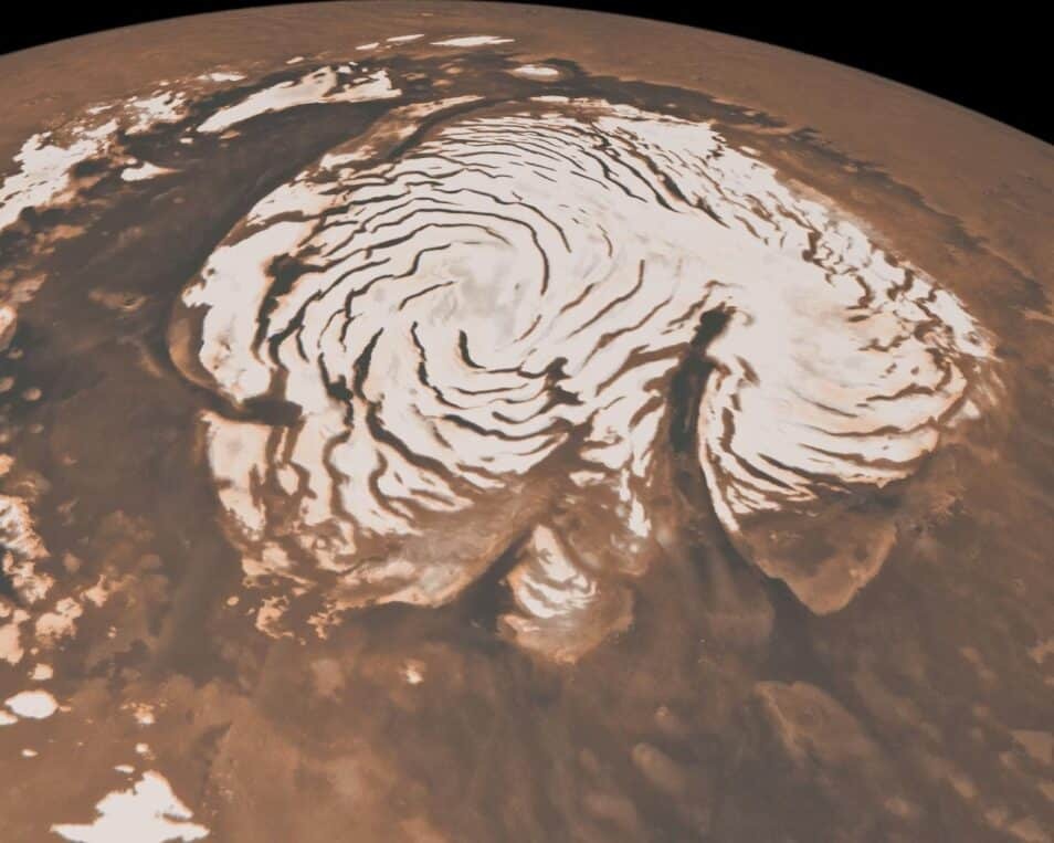
Powerful Winds
For Isaac Smith of Toronto’s York University, one of the most fascinating subjects in springtime is the Texas-size ice cap at Mars’ north pole. Etched into the icy dome are swirling troughs, revealing traces of the red surface below. The effect is like a swirl of milk in a café latte.
“These things are enormous,” Smith said, noting that some are a long as California. “You can find similar troughs in Antarctica but nothing at this scale.”
Fast, warm wind has carved the spiral shapes over eons, and the troughs act as channels for springtime wind gusts that become more powerful as ice at the north pole starts to thaw. Just like the Santa Ana winds in Southern California or the Chinook winds in the Rocky Mountains, these gusts pick up speed and temperature as they ride down the troughs — what’s called an adiabatic process.
As temperatures rise, powerful winds kick up that carve deep troughs into the ice cap of Mars’ north pole. Some of these troughs are as long as California, and give the Martian north pole its trademark swirls. This image was captured by NASA’s now-inactive Mars Global Surveyor.
Credit: NASA/JPL-Caltech/MSSS
Wandering Dunes
The winds that carve the north pole’s troughs also reshape Mars’ sand dunes, causing sand to pile up on one side while removing sand from the other side. Over time, the process causes dunes to migrate, just as it does with dunes on Earth.
This past September, Smith coauthored a paper detailing how carbon dioxide frost settles on top of polar sand dunes during winter, freezing them in place. When the frost all thaws away in the spring, the dunes begin migrating again.
Each northern spring is a little different, with variations leading to ice sublimating faster or slower, controlling the pace of all these phenomena on the surface. And these strange phenomena are just part of the seasonal changes on Mars: the southern hemisphere has its own unique activity.
Surrounded by frost, these Martian dunes in Mars northern hemisphere were captured from above by NASAs Mars Reconnaissance Orbiter using its HiRISE camera on Sept. 8, 2022.
Credit: NASA/JPL-Caltech/University of Arizona
More About MRO
The University of Arizona, in Tucson, operates HiRISE, which was built by Ball Aerospace & Technologies Corp., in Boulder, Colorado. NASA's Jet Propulsion Laboratory, a division of Caltech in Pasadena, California, manages the Mars Reconnaissance Orbiter Project for NASA’s Science Mission Directorate, Washington.
Recente beelden tonen dramatische veranderingen op Mars tijdens de overgang naar lente, met lawines, gasgeisers en ‘Mars-spinnen’ aan het noordelijke oppervlak.
In dit artikel belichten we aan de hand van enkele recente foto’s van Mars’ oppervlak de zich nu voltrekkende overgang naar lente op Mars’ noordelijke halfrond. Dankzij de langdurige observaties van de Mars Reconnaissance Orbiter (MRO) komen dramatische veranderingen in het landschap aan het licht. We bekijken verschillende fenomenen, waaronder afbrokkelende stukken droogijs, explosieve gasgeisers en de vorming van spin-achtige structuren aan het oppervlak, die samen een dynamisch beeld geven van de Marslente.
Martiaanse duinen. Deze hoge resolutie opname toont migrerende duinen in de noordelijke hemisfeer van Mars, omgeven door vorst (rijp van droogijs). Deze afbeelding is gemaakt met HiRISE aan boord van MRO en benadrukt de dynamiek achter duinvorming onder invloed van lokale, seizoensgebonden windsystemen. Foto: NASA/JPL-Caltech/University of Arizona
Lawines in Mars’ lente De overgang naar lente op Mars brengt aanzienlijke structurele veranderingen met zich mee. In 2015 legde de HiRISE-camera een 20-meter groot brok droogijs in vrije val vast. Deze afbrokkelende ijsmassa’s illustreren hoe door invloed van toenemende temperaturen abrupte gevolgen zoals we die ook kennen op aarde, heftige gevolgen teweegbrengen. JPL-onderzoeker Serina Diniega merkt op: “we zijn blij dat we bijna 20 jaar lang een waarnemingsplatform als MRO hebben, waarmee we deze dramatische gebeurtenissen kunnen zien voltrekken, in plaats van alleen de gevolgen van smelt.”
Droogijs-lawines. De vrije val een 20-meter groot brok bevroren koolstofdioxide, vastgelegd door HiRISE (Mars Reconaissance Orbiter) in 2015, illustreert de explosieve aard van Mars’ lentetransitie. Foto: NASA/JPL-Caltech/Univ. of Arizona
Gasgeisers, explosieve uitbarstingen en ‘Mars-spinnen’ Opwarming van de grond door toedoen van de groter wordende zonnekracht op het noorden zorgt ervoor dat onder het oppervlak gelegen reservoirs van droogijs sublimeren naar gasvormig koolstofdioxide, waardoor er actief spuwende geisers ontstaan. MRO heeft dit bijzondere proces weten vast te leggen:
Gasgeisers. Dit beeld toont gasgeisers die, als gevolg van sublimatie van ondergronds gelegen kooldioxide-ijs, donkere fonteinen van materiaal de atmosfeer in blazen en over het Martiaanse oppervlak verspreiden. Foto: NASA/JPL-Caltech/University of Arizona
Afhankelijk van de kenmerken van de grond kan er veel druk opbouwen voordat de geiser losbarst en explosief wordt. Het verschijnsel van actieve geisers en explosies van onder het oppervlak komt elk Martiaans jaar weer ten einde in de zomer en laat dan donkere spin-achtige afzettingen van zand en stof, verspreid over het oppervlak, achter; ‘Mars-spinnen’:
Mars-spinnen. Na uitrazen van de gasgeisers ontstaan lange, spinachtige deposities op het oppervlak van Mars, een kenmerkend effect van droogijs sublimatie van onder het oppervlak. Foto: NASA/JPL-Caltech/University of ArizonaClose-up van Mars-spinnen. Deze close-up toont de gedetailleerde structuur van Mars-spinnen, gevormd door langdurige sublimatie van kooldioxideijs. Foto: NASA/JPL-Caltech/Univ. of Arizona
Winderige troggen bij de noordpool De opwarming van Mars’ noordpool leidt tot lokaal krachtige winden die diepe troggen klieft in de ijsbedekking van Mars’ noordpool. Deze troggen kunnen een lengte bereiken die vergelijkbaar is met de doorsnede van pool zelf; zo’n 1.000 km.
Winderige troggen. Krachtige windstromen snijden diepe troggen in de ijsbedekking van Mars’ noordpool, welke een totale afmeting heeft van ongeveer 1.000 km. doorsnede telt in de Martiaanse winter. Rechtsonderin de getoonde ijsmassa doorklieft de Chasma Boreale canyon. Deze heeft een lengte van ongeveer 450 km. en is zo’n 2 kilometer diep. Foto: NASA/JPL-Caltech/MSSS
De beelden van Mars’ oppervlak onthullen de dynamische processen die optreden tijdens de overgang naar lente. IJslawines, explosieve gasgeisers en de ontwikkeling van Mars-spinnen tonen hoe de rode planeet onder invloed van veranderende temperaturen en sublimatie in een korte tijd drastisch verandert. Deze observaties, ondersteund door bijna 20 jaar aan hoge resolutie opnamen, bieden een unieke kans voor wetenschappers om de evoluerende krachten op Mars te bestuderen.
New Year, New Mars: Red Planet Gets Active as Spring Begins
(Mars Report)
De afgelopen decennia zijn er prachtige foto’s gemaakt van interstellaire nevels, sterrenstelsels, planeten, andere hemellichamen en in de ruimtevaart. Ieder weekend halen we een indrukwekkende ruimtefoto uit het archief. Genieten van alle foto’s? Bekijk ze op deze pagina. Heb je zelf bijzondere (astro)foto’s die je wil delen met ons? Stuur ze in via ons mailadres o.v.v. ‘Ruimtefoto’!
The James Webb Space Telescope has captured a belching protostar in its infancy. By studying the dust grains whirling around it, astronomers hope to better understand how solar systems like our own take shape.
(Image credit: ESA/Webb, NASA & CSA, Tazaki et al.)
The James Webb Space Telescope (JWST) has captured a stunning image of a young star firing energy into space, illuminating a protoplanetary disk from which a new solar system may form.
The young star, called HH 30, is a Herbig-Haro object — a bright knot of gas formed when the gas streaming from young protostars collides with nearby matter, producing shockwaves.
HH 30 is located 450 light-years away in the dark cloud LDN 1551 in the Taurus Molecular Cloud. Astronomers are studying the gassy knot to learn more about how dust grains combine with massive jets to form planets. The researchers published their findings Feb. 3 in The Astrophysical Journal.
"These grains are only one millionth of a metre across — about the size of a single bacterium," the researchers wrote in a blog post accompanying the image. "While the large dust grains are concentrated in the densest parts of the disc, the small grains are much more widespread."
Where star systems are born
Stars take tens of millions of years to form, growing from dense, billowing clouds of turbulent dust and gas to gently glowing protostars, before materializing into gigantic orbs of fusion-powered plasma like our sun.
Scientists think that planets form around young stars when dust and gas particles collide and stick together, snowballing over millions of years until they reach their final forms.
To study HH 30's edge-on disk (meaning JWST sees only the disk’s side from its vantage point near Earth), the researchers combined infrared data captured by JWST with longer-wavelength observations made by the Atacama Large Millimeter/submillimeter Array (ALMA) telescope and the Hubble Space Telescope. These data enabled the researchers to capture dust particles from millimeter down to micrometer scales.
The result is a breathtakingly detailed view of the dust's movement across the disk, showing it migrating within the disk and settling in a dense layer, where it is clumping to form the beginnings of planets. Nested alongside this are several layers of gas. One of these layers originates from the jet spat out by the star, while others are from a broader cone-shaped outflow enveloped by a nebula reflecting the star's light.
"Together, these data reveal HH 30 to be a dynamic place, where tiny dust grains and massive jets alike play a role in the formation of new planets," the researchers wrote.
Uranus’ Moon Ariel has Deep Gashes, Could Reveal its Interior
We’ve only gotten one close-up view of Uranus and its moons, and it happened decades ago. In 1986, Voyager 2 performed a flyby of Uranus from about 81,500 km (50,600 mi) of the planet’s cloud tops. It was 130,000 km (80,000 mi) away from Uranus’ moon, Ariel, when it captured the leading image. It showed some unusual features that scientists are still puzzling over.
What do they reveal about the moon’s interior?
Ariel has the usual crater-pitted surface that most Solar System objects display. But its surface also has complex features like ridges, canyons, and steep banks and slopes called scarps. Research published last year suggested that these surface features and chemical deposits are caused by chemical processes inside the moon. Ariel could even have an internal ocean, according to the research.
New research published in The Planetary Science Journal digs deeper into the issue to try and understand what processes could create Ariel’s surface features. Its title is “Ariel’s Medial Grooves: Spreading Centers on a Candidate Ocean World.” The lead author is Chloe Beddingfield from Johns Hopkins University Applied Physics Laboratory (JHUAPL).
“Ariel is a candidate ocean world, and recent observations from the James Webb Space Telescope (JWST) confirmed that its surface is mantled by a large amount of CO2 ice mixed with lower amounts of CO ice,” Beddingfield and her co-researchers write in their paper. These materials should be unstable on Ariel, though, and should sublimate away into space. “Consequently, the observed constituents on Ariel are likely replenished, possibly from endogenic sources,” the authors write.
The research is centred on Ariel’s chasma-medial groove systems and how they formed. These are trenches that cut straight through the moon’s huge canyons. While previous research has suggested that the trenches are tectonic fractures, this research arrives at a different hypothesis. “We present evidence that Ariel’s massive chasma-medial groove systems formed via spreading, where internally sourced material ascended and formed new crust,” the paper states.
This Voyager 2 image of Ariel shows the names of some of the moon’s surface features. Image Credit: By Ariel_(moon).jpg: NASA/Jet Propulsion Labderivative work: Ruslik (talk) – Ariel_(moon).jpg, Public Domain, https://commons.wikimedia.org/w/index.php?curid=12867133
This is similar to ocean-floor spreading on Earth, which is where new crust forms. If true, it can account for Ariel’s surface deposits of carbon dioxide ice and other carbon-bearing molecules.
“If we’re right, these medial grooves are probably the best candidates for sourcing those carbon oxide deposits and uncovering more details about the moon’s interior,” Beddingfield said in a press release. “No other surface features show evidence of facilitating the movement of materials from inside Ariel, making this finding particularly exciting.”
Ariel’s surface is dominated by three main terrain types: plains, ridged terrain, and cratered terrain. The cratered terrain is the oldest and most extensive type of terrain. The ridged terrain is the second main terrain type and is made of bands of ridges and troughs that can extend for hundreds of kilometres. The plains are the third type and are the youngest of the terrains. They’re on canyon floors and in depressions in the middle of the cratered terrain.
As far as scientists can tell, the grooves that intersect the canyons are the youngest surface features on Ariel. Previous research suggested that they result from the interplay between volcanic and tectonic processes. However, this research says otherwise: spreading could be responsible.
This image (Figure 1) from the research puts Ariel’s complex surface on full display. The locations of the three known medial grooves are shown in red. Image Credit: Beddingfield et al. 2025.
In the 1960s, scientists validated the idea of seafloor spreading on Earth, which led to the acceptance of plate tectonics. One of the main pieces of evidence for plate tectonics is the way the edges of continents like Africa and South America fit together if you “remove” the Atlantic Ocean and the intervening seafloor.
The same thing happened when Beddingfield and her colleagues “removed” the chasm floors on Ariel.
The researchers showed that when they removed the floors of the chasms, the margins lined up. This is strong evidence of spreading. “The margins of Brownie, Kewpie, Korrigan, Pixie, and Sylph Chasmata closely align when the Intermediate Age Smooth Materials (orange unit in Figure 1), which make up the chasma floors, are removed and the Cratered Plains (green unit in Figure 1) are reconstructed,” they write.
This figure from the study shows possible configurations of Ariel’s Cratered Plains before (left) and after (right) spreading occurred. Note how neatly the chasma walls line up. “Our reconstruction focuses on removing the young chasma floors, examining the offset of the Kra Chasma segments, and aligning the similarly shaped chasma walls,” the authors write. Image Credit: Beddingfield et al. 2025.
According to the research, spreading centers develop above convention cells underneath Ariel’s crust, and heat forces material upward to the crust. The material cools at the surface, forming new crust. The entire process is driven by tidal forces as Ariel orbits the much larger Uranus. This heats the moon’s interior, creating the convection. Some of the moon’s interior cycles between heating as the moon follows its orbit. It’s possible that internal material continuously melts and then refreezes.
“It’s a fascinating situation — how this cycle affects these moons, their evolution and their characteristics,” Beddingfield said.
Like other Solar System moons that experience tidal heating, Ariel may have an ocean under its surface. In a 2024 study, researchers proposed that another of Uranus’ moons, Miranda, could have a subsurface ocean maintained by tidal heating.
However, Beddingfield is skeptical about drawing a connection between Ariel’s grooves and a potential ocean.
“The size of Ariel’s possible ocean and its depth beneath the surface can only be estimated, but it may be too isolated to interact with spreading centers,” she said. “There’s just a lot we don’t know. And while carbon oxide ices are present on Ariel’s surface, it’s still unclear whether they’re associated with the grooves because Voyager 2 didn’t have instruments that could map the distribution of ices.”
The connection between the grooves and the materials deposited on Ariel’s surface is stronger though. “These new results suggest a possible mechanism for emplacing fresh material and short-lived compounds, including carbon monoxide and perhaps ammonia-bearing species on the surface,” said Tom Nordheim, a co-author of this research and the 2024 paper.
“Our results indicate that medial grooves in large chasmata on Ariel are spreading centers, resulting from the exposure of subsurface material, creating new crust,” the authors summarize in their conclusion. “Thus, these features are likely geologic conduits to Ariel’s interior and could be the primary source of CO2, CO, and other volatiles detected on its surface.”
Richard Cartwright from the Johns Hopkins Applied Physics Laboratory led the 2024 study that used the JWST to identify CO ice and CO2 deposits on Ariel. To find more answers about this intriguing moon, Cartwright says we need a dedicated mission to Uranus and its moons. “We need an orbiter that can make close passes of Ariel, map its medial grooves in detail, and analyze their spectral signatures for components like carbon dioxide and carbon monoxide,” he said. “If carbon-bearing molecules are concentrated along these grooves, then it would strongly support the idea that they’re windows into Ariel’s interior.”
The authors agree that only a dedicated mission can provide answers. “The medial grooves are some of the youngest geologic features observed on Ariel, and close flybys of these features by a future Uranus orbiter are imperative to gain insight into recent geologic events and the geologic and geochemical properties of this candidate ocean world,” they write.
There’ve been many proposed missions to Uranus. NASA, the ESA, JAXA, and the CNSA (China National Space Administration) have all had proposals. NASA’s Uranus Orbiter and Probe mission would study Uranus and its moons from orbit by conducting multiple flybys of each major moon. The probe would enter Uranus’ atmosphere. However, even if selected, a plutonium shortage means the mission wouldn’t launch until the mid or late 2030s.
A graphic explaining some of the features of NASA’s proposed Uranus Orbiter and Probe mission. Image Credit: NASA.
So far, only China has firm plans to send a spacecraft to the ice giant. It will be part of their Tianwen-4 mission to Jupiter and would perform a single flyby of Uranus. The next launch windows for a mission to Uranus are between 2030 and 2034, but China’s mission isn’t scheduled until 2045.
A Recent Impact on Mars Shook the Planet to Its Mantle
A Recent Impact on Mars Shook the Planet to Its Mantle
New research suggests an impact recently rattled Mars deeper than thought.
HiRISE images a recent impact crater in the Cerberus Fossae region, seen on March 4, 2021. Credit: NASA/MRO/HiRISE
Something really rang the Red Planet’s bell. Research involving two NASA missions—the Mars Reconnaissance Orbiter, and the late InSight lander—has shed light on meteorite impacts and the seismic signals they produce. In a crucial finding, these signals may penetrate deeper inside Mars than previously thought. This could change how we view the interior of Mars itself.
The interior of Mars, and InSight’s detection of impacts versus geologic activity. Credit: NASA/JPL-Caltech.
The study comes from two papers published this week in the journal ofGeophysical Research Letters. The primary data comes from NASA’s InSight mission, the first dedicated geodesy mission to Mars. Insight landed in the Elysium Planitia region of Mars on November 26th, 2018, and carried the first ever dedicated seismometer to the Red Planet. During its four years of operation, Insight detected over 1,300 ‘marsquakes,’ until the mission’s end in 2022. Most were due to geologic activity, while a few were due to distant meteorite impacts. Occasionally, InSight would even see ‘land tides’ due to the passage of the moonPhobos overhead.
InSight uses its robotic arm to place a wind shield over the SEIS seismometer. µCredit: NASA/JPL-Caltech.
A Distant Mars Impact
As on Earth, the detection of seismic waves gives us the opportunity to probe the interior of Mars, providing clues as to the density, depth and thickness of the crust, mantle and core. To be sure, impacts have been correlated to seismic waves captured by InSight in the past. A fresh crater seen by NASA’s Mars Reconnaissance Orbiter (MRO) in 2022 was correlated to an impact in the Amazonis Planitia region. But this was the first time an impact in the quake-prone Cerberus Fossae area was linked to InSight detections. The find is especially intriguing, as the area is quarter of a world away from the InSight landing site, at 1,640 kilometers (1,019 miles) distant.
A wider context view of the Cerberus Fossae region on Mars, courtesy of Mars Odyssey. NASA/JPL-Caltech.
The discovery of the 21.5-meter (71 foot) crater about the length of a semi-truck immediately presented scientists with a mystery. The smoking gun impact crater was more distant than thought. Typically, the Martian crust was thought to have a dampening effect on distant impacts. This means that the impact-generated waves took a more direct route via a ‘seismic highway,’ through the deeper mantle of the planet itself.
This discovery has key implications for what we generally think about the interior of Mars. This may also imply that our understanding and model for the planet’s interior may be due for an overhaul.
“Composition of the crust and how seismic waves from impacts travel through them is one factor,” Andrew Good (NASA-JPL) told Universe Today. “No current plans for follow-on seismometers on Mars, but there is a seismometer planned for the Moon in the near future,” says Good, in reference to the Farside Seismic Suite planned for 2026.
A New View of the Interior of Mars?
InSight team member Costantinos Charalambous of Imperial College London explains the finding in more detail, in an email to Universe Today:
The detection of this impact changes our understanding of Mars’ interior, particularly its crust and upper mantle, both immediately and in the longer term. However, in the latter case, it will take further work to know quite how!
The immediate shift in our understanding is that many more of the seismic events we detected at InSight have penetrated much deeper into the planet than we thought. Previously, we had thought that the crust would trap most of the high-frequency seismic energy, guiding it around the planet from the point of impact to InSight’s seismometer. We thought any high-frequency energy that penetrated more deeply into the mantle was quickly lost. But it now appears the Martian mantle is much better at propagating this seismic energy than we thought, allowing it to travel more quickly and farther. This tells us that the mantle has a different elemental composition that previously assumed, likely with a lower iron oxide content than earlier models predicted.
Additionally, because this impact was detected in Cerberus Fossae – a region where many recorded marsquakes likely originate – it provides a unique opportunity to distinguish seismic signatures generated by seismic activity driven by deeper, internal (tectonic) forces versus shallower, external (impact) sources.
Therefore, in the longer term, we will be re-examining the data from seismic events that we had previously assumed didn’t penetrate deeper into Mars. This work is ongoing, but these findings suggest new features of Mars’ upper mantle that we are seeking to confirm. Watch this space!
MRO’s Hunt For Impacts
Just how researchers imaged the tiny crater is the amazing second part of the story. NASA’s venerable MRO generates tens of thousands of images of the surface of Mars. These come mainly via the spacecraft’s onboard Context Camera. For years, researchers have used a machine learning algorithm to sift through the images. This looks for fresh impact sites that do not appear in previous frames. These areas are in turn flagged for closer scrutiny with the mission’s 0.5-meter High-Resolution Imaging Science Experiment (HiRISE) camera. The AI program was developed by NASA’s Jet Propulsion Laboratory.
A crater cluster on Mars, one of the first spotted courtesy the MRO AI search program. Credit: NASA/JPL-Caltech/MSSS.
To date, the team has found 123 new craters within 3,000 kilometers (1,864 miles) of the InSight landing site. 49 of these (including the Cerberus Fossae impact) are potential matches with InSight seismology data.
“Done manually, this would be years of work,” says InSight team member Valentin Bickel (University of Bern, Switzerland) in a recent press release. “Using this tool, we went from tens of thousands of images to just a handful in a matter of days.”
InSight’s Legacy
InSight provided a wealth of seismology and geological information about Mars. The Seismic Experiment for Interior Structure (SEIS) instrument worked as planned. The Heat Flow and Physical Properties Package (HP^3) failed, however, to reach its target depth for returning useful science about the planet’s interior. Unfortunately, no dedicated follow on geology mission is set to head to Mars. This sort of exciting science will probably have to wait until the hoped for crewed missions of the 2030s.
InSight was a collaborative effort between NASA, the German Space Agency (DLR) and the French Space Agency (CNES). Other international partners also participated in the ground-breaking mission.
Still, it’s great to see missions like InSight still generating scientific results, long after they’ve fallen silent.
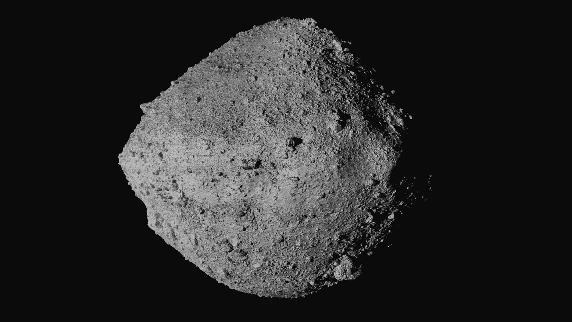
Researchers found that, in addition to a huge blast triggering earthquakes and tsunamis, Bennu's impact would kick up enough dust to trigger a two-year-long 'impact winter'.
Using a supercomputer and cutting-edge climate simulations, researchers from Pusan National University in South Korea predicted what would happen as Bennu injected millions of tonnes of dust into the atmosphere.
As dust blocks out light from the sun, the world would become cold and dry with temperatures falling 4˚C (7.2˚F) and global rainfall reducing by 15 per cent.
In some areas, including North America, precipitation would plummet between 30 and 60 per cent, making it nearly impossible to grow crops.
Lead author Dr Lan Dai, says: 'This would likely cause massive disruptions in global food security.'
Scientists have calculated what would happen if the asteroid Bennu hit the Earth. Their simulations show that the world would become colder, darker, and drier in a years-long 'impact winter' (stock image)
The 500-metre wide asteroid Bennu (pictured) has a one in 2,700 chance of hitting the planet in 2182 - similar odds to flipping a coin 11 times and getting the same outcome each time.
Asteroids the size of Bennu are believed to hit Earth every 100,000-200,000 years, so it is likely that our early ancestors have already survived one of these impacts.
But what both Chicxulub and Bennu's impact would have in common is the massive disruption of global climate patterns.
Just like the theorised 'nuclear winter' that would follow a thermonuclear war, the explosion of an asteroid impact would eject a vast column of dust into the atmosphere.
If Bennu hit Earth, Dr Dai and his co-authors estimate that 100 to 400 million tonnes of dust would linger above Earth for around two years.
Those dust particles would act like a vast planet-wide umbrella, shading Earth from the sun's radiation and reflecting heat energy back out into space.
At its peak, the amount of shortwave radiation reaching Earth would fall by 28 per cent in the worst-case scenario.
Likewise, global temperature averages would fall by 1.6°C (2.9°F), 2.7°C (4.9°F), 3.4°C (3.1°F), and 4.0°C (7.2˚F) for dust injections of 100, 200, 300, and 400 million tonnes of dust respectively.
If Bennu (illustrated) hit Earth it would first cause an explosion big enough to trigger earthquakes and tsunamis. However, the more lasting impact would come from the 100-400 million tonnes of dust that would be ejected into the atmosphere
The simulations show that the dust would banket Earth, blocking out the sun and leading to massive reductions in light (purple graph), surface temperature (pink graph), and precipitation (green graph)
What would happen in Bennu hit Earth?
Initial impact
Bennu would release the energy equivalent of 1,450 megatons of TNT, triggering earthquakes and tsunamis around the world.
Climate changes
As Bennu injects 100-400 million tonnes of dust into the atmosphere, it would cool the planet.
Average temperatures would fall 4˚C (7.2˚F).
Average rainfall would decrease 15 per cent with some areas receiving 60 per cent less rain.
Food crisis
These changes would make many regions unable to grow crops.
Photosynthesis would fall up to 30 per cent.
Crop yields in East Asia could fall by as much as 50 per cent.
Eurasia and North America would experience the most severe and rapid cooling as the dust concentrates in the northern hemisphere during the winter.
The simulation shows that global cooling will persist for up to four years after the impact, with a slow recovery starting after 24 months.
In the worst-case scenario, the rapid 'impact winter' would be equivalent to the disastrous global cooling caused by the Toba eruption which occurred around 74,000 years ago.
Additionally, the researchers predict that the disruption to patterns of evaporation over the oceans will lead to 'massive drying' in many parts of the world.
Six months after the impact, global mean precipitation will be 0.46mm per day less, a reduction of around 15 per cent.
However, this will be accompanied by large increases in precipitation in some areas of the subtropics and severe droughts in others.
To make matters worse, the Bennu dust cloud would also cause rapid erosion of the ozone layer as radiation and heat become trapped in the upper atmosphere.
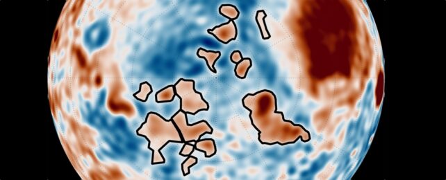
These maps show the predicted reductions in temperature (top) and precipitation (bottom) for the first two years after an impact. These show that the temperatures would fall by 4˚C (7.2˚F) and global rainfall would reduce by 15 per cent
These conditions would trigger huge reductions in the productivity in land (top) and marine (bottom) ecosystems. That would lower crop yields and destabilise global agriculture. On these maps darker regions show areas of greater reduction.
The researchers predict that the global ozone column could be depleted by 32 per cent.
Although it would be offset by the blanketing dust, this could lead to dangerous increases in levels of UV radiation which causes sunburns, blindness, and cancer.
In their paper, published in Science Advances, the researchers say these changes would 'severely reduce the habitat suitability for humans'.
Dr Dai says: 'The abrupt "impact winter" would provide unfavourable climate conditions for plants to grow, leading to an initial 20–30 per cent reduction of photosynthesis in terrestrial and marine ecosystems.'
During the first summer after the impact, the rate at which ecosystems grow and store biomass, known as net primary productivity, would fall by 36 per cent on land and 25 per cent in the oceans.
Meanwhile, crop yields in East Asia could fall by as much as 50 per cent, potentially triggering widespread starvation.
However, some of Earth's ecosystems could actually stand to benefit from such a disaster.
Although they initially take a hit, the simulation shows that marine ecosystems would not only survive but thrive in the years after the impact.
If Bennu contains a large amount of iron, it could actually help marine ecosystems flourish by effectively fertilising the oceans. Pictured: A sample of Bennu prepared for testing
As the iron enters the ocean it would lead to an algae bloom, like this one seen over a tropical reef, which would support support the marine ecosystem. The researchers say this could help humanity feed itself during the years of impact winter
After just six months, plankton in the ocean would have already recovered and would continue to increase to levels not even seen under normal climate conditions.
This unexpected bloom would be caused by a high proportion of iron in the asteroid's dust.
Iron is a key nutrient for plankton's growth but many areas such as the Southern Ocean and the eastern tropical Pacific are naturally iron-poor.
As the dust from the asteroid settles it would trigger a bloom of photosynthesising diatoms which in turn would attract zooplankton, small predators which feed on the diatoms.
'The simulated excessive phytoplankton and zooplankton blooms might be a blessing for the biosphere and may help alleviate emerging food insecurity related to the longer-lasting reduction in terrestrial productivity,' says Dai.
Around 66 million years ago non-avian dinosaurs were wiped out and more than half the world's species were obliterated.
This mass extinction paved the way for the rise of mammals and the appearance of humans.
The Chicxulub asteroid is often cited as a potential cause of the Cretaceous-Paleogene extinction event.
The asteroid slammed into a shallow sea in what is now the Gulf of Mexico.
The collision released a huge dust and soot cloud that triggered global climate change, wiping out 75 per cent of all animal and plant species.
Researchers claim that the soot necessary for such a global catastrophe could only have come from a direct impact on rocks in shallow water around Mexico, which are especially rich in hydrocarbons.
Within 10 hours of the impact, a massive tsunami waved ripped through the Gulf coast, experts believe.
Around 66 million years ago non-avian dinosaurs were wiped out and more than half the world's species were obliterated. The Chicxulub asteroid is often cited as a potential cause of the Cretaceous-Paleogene extinction event (stock image)
This caused earthquakes and landslides in areas as far as Argentina.
While investigating the event researchers found small particles of rock and other debris that was shot into the air when the asteroid crashed.
Called spherules, these small particles covered the planet with a thick layer of soot.
Experts explain that losing the light from the sun caused a complete collapse in the aquatic system.
This is because the phytoplankton base of almost all aquatic food chains would have been eliminated.
It's believed that the more than 180 million years of evolution that brought the world to the Cretaceous point was destroyed in less than the lifetime of a Tyrannosaurus rex, which is about 20 to 30 years.
NASA is bringing forward a new rescue mission for stranded astronauts after mounting political pressure.
Insiders say the space agency will bring Sunita Williams and Butch Wilmore home around March 19 — about two weeks earlier than the original early April return.
By that date, they will have spent 286 days in space.
Williams and Willmore have been stuck on the International Space Station (ISS) since June 2024, bringing them close to eight months on the orbiting laboratory when they were originally scheduled for an eight-day stay.
The new plan should allow the spacecraft that will bring Williams and Wilmore home to depart from the ISS earlier than previously scheduled.
The move comes less than one week since President Donald Trump told Elon Musk to 'go get' the pair after they were 'virtually abandoned by the Biden administration.'
Thus, Musk and Trump may see this scheduling change as a political win.
But NASA sources told Ars Technica that this contingency plan was set into motion before Trump took office and was just recently greenlit.
NASA is expected to announce a new return date for astronauts Sunita Williams and Butch Wilmore, who have been stuck on the ISS for more than eight months
The Space X Crew-10 mission was initially scheduled to launch in February, but a technical issue with the new Dragon capsule SpaceX intended to use prompted NASA to push the launch back to March.
This decision also delayed Williams and Wilmore's flight back to Earth from the International Space Station (ISS), with NASA giving an estimated return date of early April.
That's because the stranded astronauts are planning to hitch a ride home on the SpaceX Crew-9 return flight. The Crew-9 astronauts and their spacecraft have been at the ISS with Williams and Wilmore since September 29.
But they cannot depart from the space station until the Crew-10 astronauts arrive to replace them.
That is because NASA protocol necessitates a 'handover period,' or a window of time where the previous ISS crew overlaps with the incoming crew to share information with them and ensure a smooth transition between the two teams.
Therefore, getting the Crew-10 mission off the ground sooner would also allow Williams and Wilmore to come home earlier.
The Dragon capsule SpaceX was originally planning to use for this mission — called C213 — is still under development, and the Crew-10 mission was supposed to be its maiden voyage.
But SpaceX and NASA are currently working to resolve a technical issue with C213 Dragon, which may be related to batteries on the spacecraft, Ars Technica reported.
As a result, NASA decided that C213 would not be ready to launch until late April.
At first, NASA opted to push back the Crew-9 return date in order to accommodate the Crew-10 mission delay.
But at this point, if NASA waited for C213 to be ready to launch the Crew-10 mission, the astronauts currently on board the ISS 'would start to approach "redlines" on food, water and other supplies,' Ars Technica reported.
So, in the interest of returning NASA's stranded astronauts to Earth 'as soon as possible' (as SpaceX CEO Elon Musk recently promised to do) NASA and SpaceX have reportedly decided to replace C213 with the C210 vehicle, which was used for the Crew-7 mission that returned to Earth in March 2024.
Known as 'Endurance,' this spacecraft will now be used to launch the Crew-10 mission no earlier than March 12, sources told Ars Technica.
If Crew-10 launches on time, Williams, Wilmore and the Crew-9 astronauts could return to Earth on March 19.
By that date, Williams and Wilmore will have spent 286 days in space, which is far longer than their mission was originally intended to be.
One June 5, these two NASA astronauts flew to the ISS for what was supposed to be an eight-day aboard the floating laboratory.
But their spacecraft, Boeing's Starliner, was mired by technical issues before, during and after the launch, prompting NASA to delay the astronauts' return while the agency worked with Boeing to resolve the issues.
Ultimately, Starliner was deemed unfit to carry Williams and Wilmore home, and thus the spacecraft returned to Earth uncrewed in September.
Since then, the two astronauts have been waiting to come home aboard the Crew-9 spacecraft, which arrived at the ISS later that same month.
On January 28, Elon Musk made a post on his social media platform, X, stating: 'The [President of the United States] has asked [SpaceX] to bring home the 2 astronauts stranded on the as soon as possible. We will do so. Terrible that the Biden administration left them there so long.'
President Donald Trump confirmed the plan in a post on his own social media site, Truth Social: 'I have just asked Elon Musk and [SpaceX] to “go get” the 2 brave astronauts who have been virtually abandoned in space by the Biden Administration.
'They have been waiting for many months on [the ISS]. Elon will soon be on his way. Hopefully, all will be safe. Good luck Elon!!!'
The statements spurred confusion as they seemed to convey that Musk himself would be flying to the ISS (which is not the case) and undermined the fact that SpaceX had already been tasked with bringing Williams and Wilmore home.
With NASA now moving to bring the Starliner crew home two weeks earlier just days after these statements were made, it may appear as though the schedule change was politically motivated.
But Ars Technica reported that the scheduling change was made spurred by 'pragmatism,' not politics.
Prior to the Crew-10 spacecraft swap, Endurance was not scheduled to fly again until later this spring, when it would launch the private Axiom-4 mission to the space station.
As a result, Axiom-4's will be delayed, sources said.
NASA's stranded astronauts face more time in space as rescue mission is delayed yet again | ITV News
Astronomers Find the Largest Structure in the Universe and Name it “Quipu”
This image shows five newly-discovered superstructures. Quipu (red) is the largest structure ever found in the Universe. The others are Shapley (blue), Serpens-Corona Borealis (green), Hercules (purple) and Sculptor-Pegasus (beige). Image Credit: Bohringer et al. 2025.
Astronomers Find the Largest Structure in the Universe and Name it “Quipu”
Is it possible to understand the Universe without understanding the largest structures that reside in it? In principle, not likely. In practical terms? Definitely not. Extremely large objects can distort our understanding of the cosmos.
Astronomers have found the largest structure in the Universe so far, named Quipu after an Incan measuring system. It contains a shocking 200 quadrillion solar masses.
Astronomy is an endeavour where extremely large numbers are a part of daily discourse. But even in astronomy, 200 quadrillion is a number so large it’s rarely encountered. And if Quipu’s extremely large mass doesn’t garner attention, its size surely does. The object, called a superstructure, is more than 400 megaparsecs long. That’s more than 1.3 billion light-years.
A structure that large simply has to affect its surroundings, and understanding those effects is critical to understanding the cosmos. According to new research, studying Quipu and its brethren can help us understand how galaxies evolve, help us improve our cosmological models, and improve the accuracy of our cosmological measurements.
“For a precise determination of cosmological parameters, we need to understand the effects of the local large-scale structure of the Universe on the measurements,” the authors write. “They include modifications of the cosmic microwave background, distortions of sky images by large-scale gravitational lensing, and the influence of large-scale streaming motions on measurements of the Hubble constant.”
Superstructures are extremely large structures that contain groups of galaxy clusters and superclusters. They’re so massive they challenge our understanding of how our Universe evolved. Some of them are so massive they break our models of cosmological evolution.
Quipu is the largest structure we’ve ever found in the Universe. It and the other four superstructures the researchers found contain 45% of the galaxy clusters, 30% of the galaxies, 25% of the matter, and occupy a volume fraction of 13%.
The image below helps explain why they named it Quipu. Quipu are recording devices made of knotted cords, where the knots contain information based on colour, order, and number. “This view gives the best impression of the superstructure as a long filament with small side filaments, which initiated the naming of Quipu,” the authors explain in their paper.
This figure from the new research is a wedge diagram in declination and distance of the Quipu superstructure. The distance is in units of Megaparsecs. The red dots show the superstructure members and the black lines show the friends-to-friends linking. The grey dots show the non-member clusters. The two dashed lines give the distances for redshifts of 0.03 and 0.06.
In their work, Bohringer and his co-researchers found Quipu and four other superstructures within a distance range of 130 to 250 Mpc. They used X-ray galaxy clusters to identify and analyze the superstructures in their Cosmic Large-Scale Structure in X-rays (CLASSIX) Cluster Survey. X-ray galaxy clusters can contain thousands of galaxies and lots of very hot intracluster gas that emits X-rays. These emissions are the key to mapping the mass of the superstructures. X-rays trace the densest regions of matter concentration and the underlying cosmic web. The emissions are like signposts for identifying superstructures.
This figure from the research shows galaxy distribution in density gradients. The density ratio to the average density is shown by six contour levels: 0 – 0.23 (black), 0.23 – 0.62 (dark blue), 0.62 – 1.13 (light blue), 1.13 – 1.9 (grey), 1.9 – 3.7 (olive), and > 3.7 (white). The clusters of the five superstructures are overplotted with filled black circles.Image Credit: Bohringer et al. 2025.
The authors point out that “the difference in the galaxy density around field clusters and members of superstructures is remarkable.” This could be because field clusters are populated with less massive clusters than those in the superstructure rather than because the field clusters have lower galaxy density.
Regardless of the reasons, the mass of these superstructures wields enormous influence on our attempt to observe, measure, and understand the cosmos. “These large structures leave their imprint on cosmological observations,” the authors write.
The superstructures leave an imprint on the Cosmic Microwave Background (CMB), which is relic radiation from the Big Bang and key evidence supporting it. The CMB’s properties match our theoretical predictions with near-surgical precision. The superstructures’ gravity alters the CMB as it passes through them according to the Integrated Sachs-Wolfe (ISW) effect, producing fluctuations in the CMB. These fluctuations are foreground artifacts that are difficult to filter out, introducing interference into our understanding of the CMB and, hence, the Big Bang.
The full-sky image of the temperature fluctuations (shown as colour differences) in the cosmic microwave background is made from nine years of WMAP observations. These are the seeds of galaxies from a time when the universe was under 400,000 years old. Credit: NASA/WMAP
The superstructures can also impact measurements of the Hubble constant, a fundamental value in cosmology that describes how fast the Universe is expanding. While galaxies are moving further apart due to expansion, they also have local velocities, called peculiar velocities or streaming motions. These need to be separated from expansion to understand expansion clearly. The great mass of these superstructures influences these streaming motions and distorts our measurements of the Hubble constant.
The research also notes that these massive structures can alter and distort our sky images through large-scale gravitational lensing. This can introduce errors in our measurements.
On the other hand, simulations of the Lambda CDM produce superstructures like Quipu and the four others. Lambda CDM is our standard model of Big Bang cosmology and accounts for much of what we see in the Universe, like its large-scale structure. “We find superstructures with similar properties in simulations based on Lambda-CDM cosmology models,” the authors write.
It’s clear that these superstructures are critical to understanding the Universe. They hold a significant portion of its matter and affect their surroundings in fundamental ways. More research is needed to understand them and their influence.
“Interesting follow-up research on our findings includes, for example, studies of the influence of these environments on the galaxy population and evolution,” the authors write in their conclusion.
According to the study, these superstructures won’t persist forever. “In the future cosmic evolution, these superstructures are bound to break up into several collapsing units. They are thus transient configurations,” Bohringer and his co-researchers explain.
“But at present, they are special physical entities with characteristic properties and special cosmic environments deserving special attention.”
RELATED VIDEOS
Astronomers Have Discovered the Biggest Structure in the Universe
The Largest Structure in the Universe Has Blown Science Away.
NASA researchers have identified geological structures on Mars that are unlike anything found on Earth. From spider-like formations shaped by underground CO₂ eruptions to towering geysers blasting dark dust over the planet’s poles, these findings continue to puzzle scientists. The discovery provides new insights into the planet’s geological activity and raises intriguing questions about Mars’ dynamic environment.
Dense gravitational structures in the northern hemisphere.
High-resolution images from NASA’s Mars Reconnaissance Orbiter have captured an extraordinary sight: vast, web-like formations stretching across the Martian southern polar region. These patterns, known as araneiform terrain, are formed through a process unlike anything seen on Earth. Trapped carbon dioxide gas builds up beneath a thick layer of seasonal ice and erupts in sudden outbursts, carving intricate channel-like structures into the surface.
On Earth, landscapes are shaped primarily by water, wind, and tectonic activity. However, Mars’ extreme conditions allow for an entirely different process. During the Martian winter, CO₂ accumulates under the ice cap. When spring arrives and sunlight warms the ground beneath, the trapped gas sublimates—turning directly from solid to gas—until pressure forces an eruption, leaving behind these strange formations.
This colorized image of the surface of Mars was taken by the Mars Reconnaissance Orbiter. The line of three volcanoes is the Tharsis Montes, with Olympus Mons to the northwest. Valles Marineris is to the east.
(NASA/JPL-Caltech/Arizona State University)
CO₂ Geysers and the Changing Martian Surface
In addition to the spider-like formations, scientists have observed massive dark patches appearing across Mars’ surface. These marks result from CO₂ geysers—violent gas eruptions that propel dust and sediment into the thin Martian atmosphere. First described in 2006, these “Keiffer geysers” are believed to be seasonal, forming when trapped gas suddenly breaks through the ice cap.
As sunlight penetrates the frozen CO₂ layer, it heats the ground below, creating an increasing buildup of pressure. When this pressure exceeds the ice’s ability to contain it, gas and dust erupt in powerful jets, leaving behind vast dark stains. These seasonal changes challenge previous notions that Mars’ polar caps are static, revealing an active and evolving environment.
The Daedalus crater on the far side of the moon as seen from the Apollo 11 spacecraft NASA
Implications for Future Mars Exploration
Studying these processes is crucial for future Mars missions. By analyzing how CO₂ accumulates and escapes, scientists hope to gain a better understanding of Mars’ atmospheric behavior and subsurface composition. Some researchers speculate that similar gas-trapping mechanisms may have once involved water, offering potential clues about Mars’ past habitability.
This research is also relevant for human exploration. If subsurface gas reservoirs exist, they could impact future settlements, resource extraction, or even strategies for sustaining human life on Mars. These findings not only provide a deeper understanding of Martian geology but could also influence the design of future missions and habitats.
What Else Might Be Hidden Beneath Mars’ Surface?
The discovery of these seasonal Martian eruptions suggests that the planet is far more geologically active than previously assumed. Could these same processes have played a role in Mars’ past climate shifts? Might similar gas-driven eruptions occur elsewhere in the solar system?
These discoveries highlight that Mars is a far more dynamic world than once believed, with seasonal processes actively reshaping its surface. Understanding these unique geological mechanisms could provide valuable insights into Mars’ past climate and the possibility of subsurface resources. Future missions may uncover even more hidden processes, potentially bringing us closer to answering whether Mars once harbored life.Could similar gas-driven eruptions exist on other planets or moons in our solar system? What implications do these findings have for future human exploration of Mars? Share your thoughts in the comments!
Scientists: Moon’s Grand Canyons Formed In 10 Minutes
Scientists: Moon’s Grand Canyons Formed In 10 Minutes
The famous Vallis Schrödinger and Vallis Planck formed in a matter of minutes after an impact of monumental proportions created the Schrödinger crater.
Moon's grand canyons next to the Schrodinger impact crater.
Credit: NASA/SVS/Ernie T. Wright
Using photogeological mapping, planetologists have studied the structure and constructed a scenario for the formation of Vallis Schrödinger and Vallis Planck, which are large lunar valleys located in the southern polar region. They appeared during the formation of the Schrödinger impact crater, apparently as a result of extremely powerful asymmetric emissions with energies of about 10 20 -10 21 joules in approximately 10 minutes.
The authors of the study note that the distribution and structure of the Schrödinger crater emissions are of interest in terms of collecting soil samples for the missions planned within the framework of the Artemis program.
A violent impact reshaped the surface of the Moon
The Schrödinger crater is located on the far side of the Moon, on the edge of the vast South Pole-Aitken impact basin, approximately 300 kilometres from the pole. It is 320 kilometres in diameter, about 4.5 kilometres deep, and is estimated to be 3.81 billion years old. The crater is surrounded by an asymmetrical ejecta layer extending for 500 kilometres, although ejected material not detected by orbital imaging may be present at a greater distance.
The ejecta resulted in multiple secondary impact events, some of which formed long depressions called valleys radiating from the crater. The longest of these are the Vallis Schrödinger and Vallis Planck. They are 270 and 280 kilometres long, about 20 and 27 kilometres wide, and about 2.7 and 3.5 kilometres deep, respectively.
Spectral studies have revealed heterogeneity of the material in the Schrödinger crater and surrounding areas. This material not only contains traces of later volcanic activity but also carries information about the most ancient events in the geological history of the Moon. The fact is that during the formation of the crater (presumably as a result of the fall of a body with a diameter of about 25 kilometres at a speed of 15 kilometres per second), rocks of the lunar crust were exposed from a depth of up to 30 kilometres. In addition, ancient ejecta from the South Pole-Aitken impact basin, which includes mantle material, were scattered across the surface.
Impact structure view and map showing the motion of the impactor (yellow line) and the axes of Vallis Planck and Vallis Schrödinger (red lines). Credit: David A. Kring et al. / Nature Communications, 2025
To clarify the distribution of the Schrödinger crater’s ejecta and the model of its formation, American and British planetologists used photogeological and topographic mapping of its secondary structures, the Schrödinger and Planck valleys, based on data from the Lunar Reconnaissance Orbiter. The diameters, depths, and distances to the centre of the Schrödinger crater and to the intersection point of the rays that continue the valleys were measured for all secondary craters that form the valleys. Based on the results obtained, the scientists calculated the speeds and directions of material ejecta from the Schrödinger crater.
It took approximately 10 minutes for the Moon’s Grand Canyons to form
For the ejecta that formed Vallis Schrödinger, the ejecta velocity ranged from 0.95 to 1.05 kilometres per second, and the angle at which the material was ejected ranged from 45 to 20 degrees (given the circular shape of the secondary craters, the ejection angle was probably closer to the upper limit of this range). The flight time of the debris ranged from 4.9 to 15.0 minutes.
The maximum velocity of the ejecta that formed Vallis Planck was higher (1.23–1.28 kilometres per second), and the material travelled a greater distance in a time of 5.2 to 15.4 minutes. The duration of the secondary bombardments in both cases did not exceed five minutes.
Images A and B show the deepest sections of Vallis Schrödinger. Images C and D show the deepest sections of Vallis Planck. Credit: David A. Kring et al. / Nature Communications, 2025
At such ejection velocities, theoretical estimates of the average size of the ejected fragments range from 0.02 to 0.05 times the diameter of the primary impactor, in this case from 0.5 to 1.25 kilometres. This is consistent with the diameters of the secondary craters in Vallis Planck, as most of them are less than two kilometres. On the other hand, the estimated sizes of the debris that resulted in the formation of Vallis Schrödinger are significantly larger than theoretical: 2.3–5.2 kilometres.
Apparently, this valley, located closer to the point of the asteroid impact, was formed as a result of a nearly simultaneous impact of an entire cluster of ejected fragments, rather than a series of individual falls. The debris was tightly grouped since the secondary craters overlap each other greatly. In contrast, in the remote part of Vallis Planck, the secondary craters were formed as a result of the falls of individual fragments, rather than a continuous stream of ejecta.
Calculations have shown that for the formation of Vallis Schrödinger, the kinetic energy of the ejected material must have been 3.39×10 20 joules, and for Vallis Planck – about 1.21×10 21 joules. The axes of the valleys, indicating the direction of the emissions, converge not in the centre of the Schrödinger crater, but at its edge, where the primary impact occurred.
The direction of the asteroid’s flight was also established along the line connecting the centre with this point: south-southeast-north-northwest. Its fall at a small (less than 45 degrees) angle caused not a point explosion, but the appearance of a distributed impact zone and an asymmetric pattern of the distribution of emissions.
Clarification of this pattern will help to detail the stratigraphy of impactites in the region and more effectively plan the collection of soil samples during future missions, in particular, within the framework of the Artemis program.
The moon has a secret underground CAVE: Scientists discover an empty lava tube beneath the lunar surface - and say it could be the perfect base for future settlers
The moon has a secret underground CAVE: Scientists discover an empty lava tube beneath the lunar surface - and say it could be the perfect base for future settlers
A pit on the moon has a 'subsurface cave conduit, tens of metres long'
READ MORE: Hole spotted on Marscould be a gateway to ancient alien life
But on the lunar surface, astronauts will be exposed to potentially deadly cosmic rays and extreme temperatures.
Now, scientists may have found a suitable hiding place from these unforgiving conditions.
The experts in Italy say they have identified the first cave on the moon, which extends from inside a pit located in the Sea of Tranquility.
It could be a promising site for a lunar base, as it offers shelter from 'the harsh surface environment' and could support long-term human exploration of the moon.
The cave extends from inside Mare Tranquillitatis Pit (pictured) which is located at the moon's famous Sea of Tranquillity - close to where humans landed in 1969
The pit leads to a 'lava tube' - a natural conduit formerly occupied by flowing molten lava - which could provide shelter for astronauts
'These caves have been theorized for over 50 years, but it is the first time ever that we have demonstrated their existence,' said study author Lorenzo Bruzzone, professor at the University of Trento in Italy.
Since pits were first discovered on the moon by JAXA's SELENE spacecraft in 2009, scientists have wondered if they led to caves that could be explored or used as shelters.
There are more than 200 pits moon, around 16 of which are thought to be collapsed 'lava tubes' – natural conduits formerly occupied by flowing molten lava.
If the ceiling of a solidified lava tube collapses, it opens a pit – but whether these pits provide access to caves has long been uncertain.
The team focused on a roughly cylindrical pit in a part of the moon's northern hemisphere, known as the Sea of Tranquility, or Mare Tranquillitatis.
Tranquility Base, the location of the first manned landing on the moon in July 1969, is located in the south-western corner of the Sea of Tranquility.
Researchers focused on a roughly cylindrical 100-meter-deep depression, about the length and width of a football field, in an area of the moon, known as the Sea of Tranquillity or Mare Tranquillitatis (marked here with a red circle)
Researchers processed images from the Diviner Lunar Radiometer Experiment - a thermal camera on NASA's robotic Lunar Reconnaissance Orbiter (depicted here in space)
Mare Tranquillitatis Pit is the deepest known pit on the moon – an estimated depth of 328 feet (100 meters) and up to 377 feet (115 meters) across – about the length of a football pitch.
NASA's Lunar Reconnaissance Orbiter, which launched in 2009, captured radar data from the pit during a flyover more than a decade ago.
But the team have now reanalysed the radar data with new 'complex signal processing techniques'.
According to the findings, a portion of the radar reflections originating from the put can be identified as a 'subsurface cave conduit, tens of metres long'.
'Thanks to the analysis of the data we were able to create a model of a portion of the conduit,' said Leonardo Carrer, researcher at University of Trento.
'[We] have discovered radar reflections from the area of the pit that are best explained by an underground cave conduit.
'This discovery provides the first direct evidence of an accessible lava tube under the surface of the moon.'
Pictured, the researchers' illustration of the shape of the cave descending from Mare Tranquillitatis Pit
NASA's Lunar Reconnaissance Orbiter, which launched in 2009, captured radar data from the pit during a flyover more than a decade ago. But the team have now reanalysed the radar data with new 'complex signal processing techniques'
This new research has implications for the development of missions to the moon, where the environment is hostile to human life.
The moon is know for temperatures that are too extreme to sustain life – up to a scorching 260°F during the day and down to an icy -280°F at night.
But temperatures in a shady cave such as this are thought to be a 'comfortable' 63°F (17°C) – suggesting they could be the perfect locations for lunar base camps.
They could also provide shelter from cosmic rays and the thousands of meteorites that are thought to hit the moon every year.
It also opens up the possibility of other lunar pits leading to cave, which would give spacefarers more options when planning to establish settlements.
NASA hopes to develop a sustainable lunar exploration program starting from 2028. This artist's illustration shows what NASA's Artemis base camp could look like
Tranquility Base, the location of the first manned landing on the moon in July 1969, is located in the south-western corner of the Sea of Tranquility. Pictured is Buzz Aldrin during the Apollo 11 moon landing on July 20, 1969
Rather than going to the Sea of Tranquility, NASA's upcoming Artemis III mission plans to land a crew at the moon's south polar region in a SpaceX craft.
Eventually as part of its Artemis programme, NASA plans to have set up a base camp in the lunar south region by the end of this decade.
Building a lunar base in a pit or cave is not currently part of the official plan, but the study authors suggest it will be worth considering in the future.
'A complete survey of all known lunar pits would allow us to identify the most promising accesses for subsurface lunar exploration and provide information on the potential for installing human lunar base in environments protected from cosmic radiation and with stable temperatures,' they conclude.
Their new study has been published today in the journal Nature Astronomy.
Why the moon needs its own timezone: Experts call for 'Coordinated Lunar Time'
From Greenwich Mean to Eastern Standard, there's more than 30 timezones in use today.
But one more may soon be added – and it would be literally out of this world.
A visit to the Grand Canyon is a true bucket list item for anyone on a US road trip.
But Arizona isn't the only place where an ambitious explorer can find a Grand Canyon.
NASA’s Lunar Reconnaissance Orbiter has snapped pictures of two gigantic basins on the lunar surface.
Named Vallis Schrödinger and Vallis Planck, these measure 168 miles (270 km) long and 1.7 miles (2.7 km) deep, and 174 miles (280 km) long and 2.2 miles (3.5 km) deep, respectively.
That makes them just as long as the Grand Canyon and more than three times as deep at their lowest points.
While Earth's canyon was formed by the Colorado River over six to seven million years, the researchers say these were carved out in just 10 minutes.
The moon's canyons stretch out from the Schrödinger impact basin, a 200-mile-wide (320 km) crater located near the moon's south pole, which was formed when a meteor slammed into the lunar surface.
The researchers think that these lunar valleys were cut into the rock by a stream of rocks thrown out from that violent impact 3.81 billion years ago.
NASA’s Lunar Reconnaissance Orbiter has snapped stunning pictures of the moon's answer to the Grand Canyon (pictured), two enormous valleys carved into the lunar surface
The canyons, named Vallis Schrödinger and Vallis Planck, are just as long as the Grand Canyon (pictured) and over three times as deep at their lowest points
The Schrödinger impact basin is located on the outer margins of the moon's 1,500-mile-wide (2,400 km) South Pole–Aitken basin.
Scientists believe it was formed when a large meteor tore into the lunar surface, creating an extremely violent explosion and tossing debris up to 310 miles (500km) from the crater rim.
This led to debris falling in long, straight lines called ejecta rays which created deep channels of overlapping craters like Vallis Schrödinger and Vallis Planck.
'Such rays are commonly observed on the Moon. For example, backyard astronomy enthusiasts will be familiar with the rays around Tycho and Copernicus craters on the near side of the Moon,' says Dr Kring.
Now, using photographs from NASA's probe, researchers have created a three-dimensional map of these valleys to model the direction and speed of the debris flow.
In their paper, published in Nature Communications, the researchers calculate that the debris must have been travelling at speeds between 2,125 and 2,863 miles per hour (3,420-4,608 kmph).
In turn, this velocity suggests that the fragments which formed the canyon would be between two and five per cent the size of the original meteor.
The Schrödinger impact basin (right and down from centre) is extremely close to the South Pole. On this map you can also see the two Lunar Grand Canyons stretching away from the crater to the right and downwards
Vallis Schrödinger and Vallis Planck measure 168 miles (270 km) and 174 miles (280 km) long respectively. On average Vallis Plank is almost a kilometre deeper than the Grand Canyon, as shown in this diagram
That means each fragment could have been up to 1,250 metres wide - more than 60 times larger than the Chelyabinsk meteor which exploded over Russia in 2013.
Dr Kring says: 'The energy to produce the two grand canyons of the moon was equal to 130 times the energy of the world’s total inventory of nuclear weapons.
'The research shows that lunar canyons the size of Earth’s Grand Canyon can form in minutes rather than millions of years. Impact-generated streams of rock on the Moon are far more capable of carving canyons than is water on Earth.'
By tracing the ejecta rays back to the point where they meet, the researchers have also been able to identify the meteor's probable impact location.
Interestingly, this point is not at the centre of the Schrödinger crater as you might expect, but rather further to the South at 78.2° South and 143.7° East.
This detail implies that the meteor probably hit the lunar surface at a fairly low angle, spraying debris away from the moon's South Pole.
Researchers say these canyons were carved into the moon by streams of rock ejected by a meteor impact which formed the Schrödinger crater (pictured)
As the debris from the impact fell down to the moon, it produced long lines of overlapping craters (highlighted green) which formed the canyons in just ten seconds
The researchers estimated that the canyons (pictured) were formed using 130 times the energy of the world’s total inventory of nuclear weapons
By tracing the canyons back to where they overlap, the researchers predict the original meteor's likely impact point. This suggests that most of the debris would have been thrown away from the South Pole, this is good news for NASA which plans to land its Artemis Missions to the south of the Schrödinger basin
However, this study suggests that this isn't likely to be too much of a problem.
Dr Kring says: 'The research suggests most of the debris ejected from the Schrödinger basin landed outside the Artemis exploration zone.
'Artemis astronauts will find it easier to collect rocks older than the Schrödinger impact.
'The Schrödinger impact formed near the end of a period of early Solar System bombardment. Geologic samples collected by missions to the lunar south polar region should help decipher the magnitude and duration of that bombardment of asteroids and comets.'
Beste bezoeker, Heb je zelf al ooit een vreemde waarneming gedaan, laat dit dan even weten via email aan Frederick Delaere opwww.ufomeldpunt.be. Deze onderzoekers behandelen jouw melding in volledige anonimiteit en met alle respect voor jouw privacy. Ze zijn kritisch, objectief maar open minded aangelegd en zullen jou steeds een verklaring geven voor jouw waarneming! DUS AARZEL NIET, ALS JE EEN ANTWOORD OP JOUW VRAGEN WENST, CONTACTEER FREDERICK. BIJ VOORBAAT DANK...
Druk op onderstaande knop om je bestand , jouw artikel naar mij te verzenden. INDIEN HET DE MOEITE WAARD IS, PLAATS IK HET OP DE BLOG ONDER DIVERSEN MET JOUW NAAM...
Druk op onderstaande knop om een berichtje achter te laten in mijn gastenboek
Alvast bedankt voor al jouw bezoekjes en jouw reacties. Nog een prettige dag verder!!!
Over mijzelf
Ik ben Pieter, en gebruik soms ook wel de schuilnaam Peter2011.
Ik ben een man en woon in Linter (België) en mijn beroep is Ik ben op rust..
Ik ben geboren op 18/10/1950 en ben nu dus 74 jaar jong.
Mijn hobby's zijn: Ufologie en andere esoterische onderwerpen.
Op deze blog vind je onder artikels, werk van mezelf. Mijn dank gaat ook naar André, Ingrid, Oliver, Paul, Vincent, Georges Filer en MUFON voor de bijdragen voor de verschillende categorieën...
Veel leesplezier en geef je mening over deze blog.