The purpose of this blog is the creation of an open, international, independent and free forum, where every UFO-researcher can publish the results of his/her research. The languagues, used for this blog, are Dutch, English and French.You can find the articles of a collegue by selecting his category. Each author stays resposable for the continue of his articles. As blogmaster I have the right to refuse an addition or an article, when it attacks other collegues or UFO-groupes.
Druk op onderstaande knop om te reageren in mijn forum
Zoeken in blog
Deze blog is opgedragen aan mijn overleden echtgenote Lucienne.
In 2012 verloor ze haar moedige strijd tegen kanker!
In 2011 startte ik deze blog, omdat ik niet mocht stoppen met mijn UFO-onderzoek.
BEDANKT!!!
Een interessant adres?
UFO'S of UAP'S, ASTRONOMIE, RUIMTEVAART, ARCHEOLOGIE, OUDHEIDKUNDE, SF-SNUFJES EN ANDERE ESOTERISCHE WETENSCHAPPEN - DE ALLERLAATSTE NIEUWTJES
UFO's of UAP'S in België en de rest van de wereld Ontdek de Fascinerende Wereld van UFO's en UAP's: Jouw Bron voor Onthullende Informatie!
Ben jij ook gefascineerd door het onbekende? Wil je meer weten over UFO's en UAP's, niet alleen in België, maar over de hele wereld? Dan ben je op de juiste plek!
België: Het Kloppend Hart van UFO-onderzoek
In België is BUFON (Belgisch UFO-Netwerk) dé autoriteit op het gebied van UFO-onderzoek. Voor betrouwbare en objectieve informatie over deze intrigerende fenomenen, bezoek je zeker onze Facebook-pagina en deze blog. Maar dat is nog niet alles! Ontdek ook het Belgisch UFO-meldpunt en Caelestia, twee organisaties die diepgaand onderzoek verrichten, al zijn ze soms kritisch of sceptisch.
Nederland: Een Schat aan Informatie
Voor onze Nederlandse buren is er de schitterende website www.ufowijzer.nl, beheerd door Paul Harmans. Deze site biedt een schat aan informatie en artikelen die je niet wilt missen!
Internationaal: MUFON - De Wereldwijde Autoriteit
Neem ook een kijkje bij MUFON (Mutual UFO Network Inc.), een gerenommeerde Amerikaanse UFO-vereniging met afdelingen in de VS en wereldwijd. MUFON is toegewijd aan de wetenschappelijke en analytische studie van het UFO-fenomeen, en hun maandelijkse tijdschrift, The MUFON UFO-Journal, is een must-read voor elke UFO-enthousiasteling. Bezoek hun website op www.mufon.com voor meer informatie.
Samenwerking en Toekomstvisie
Sinds 1 februari 2020 is Pieter niet alleen ex-president van BUFON, maar ook de voormalige nationale directeur van MUFON in Vlaanderen en Nederland. Dit creëert een sterke samenwerking met de Franse MUFON Reseau MUFON/EUROP, wat ons in staat stelt om nog meer waardevolle inzichten te delen.
Let op: Nepprofielen en Nieuwe Groeperingen
Pas op voor een nieuwe groepering die zich ook BUFON noemt, maar geen enkele connectie heeft met onze gevestigde organisatie. Hoewel zij de naam geregistreerd hebben, kunnen ze het rijke verleden en de expertise van onze groep niet evenaren. We wensen hen veel succes, maar we blijven de autoriteit in UFO-onderzoek!
Blijf Op De Hoogte!
Wil jij de laatste nieuwtjes over UFO's, ruimtevaart, archeologie, en meer? Volg ons dan en duik samen met ons in de fascinerende wereld van het onbekende! Sluit je aan bij de gemeenschap van nieuwsgierige geesten die net als jij verlangen naar antwoorden en avonturen in de sterren!
Heb je vragen of wil je meer weten? Aarzel dan niet om contact met ons op te nemen! Samen ontrafelen we het mysterie van de lucht en daarbuiten.
26-01-2018
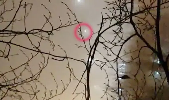
Five UFOs Moving In Formation Above Basingstoke
Five UFOs Moving In Formation Above Basingstoke
Claims of UFOs surrounded Basingstoke after five mystery lights were recorded on video appearing to fly in formation above the town.
The unnamed man said that he and a colleague noticed the lights in the sky while at work.
In a witness report to MUFON, he said he went outside with a workmate to get something out of the van, and saw one light slowly moving around the back of a building.
Then another one became visible to them from behind the building at a constant distance. Seconds later, another three came to view as if they were already there but were not lit up.
The witness said that after around a minute, they started to swing around slowly and turned around 220 degrees.
After another around a minute, two lights got further away. One stopped, and one appeared to carry on barely being a visible light source.
At this point, he said, they seemed to swing around again in formation.
To get a better view, they decided to run back inside the building and get into the roof.
Unfortunately, they could not see anything because of the fog. They decided to run back down, but those mysterious objects were nowhere to be found.
He said they did not hear noise and see flashing lights, ruling out helicopters and civilian aircraft.
He also ruled out searchlights shining up from the ground as they could clearly see the surface area of the lights getting wider as it shone down, which could entail that the light source was in the sky.
The sighting reportedly lasted around 30 minutes, and the witness had managed to take roughly four minutes of video.
WETENSCHAP & PLANEETWetenschappers hebben de tijd op de symbolische ‘Doemdagklok’ met 30 seconden vooruit gezet, naar 23:58 uur. Daarmee zijn we volgens hen amper nog twee symbolische minuten verwijderd van “het einde van de wereld”.
De klok, die in gebruik is sinds 1947, is een metafoor die aangeeft hoe dicht we staan bij de vernietiging van de aarde. Een groep wetenschappers en nucleaire experts die zich gezamenlijk het ‘Bulletin of the Atomic Scientists’ noemen, komen op regelmatige basis samen om de tijd op de Doemdagklok te bespreken.
“Met grote bezorgdheid passen we de Doemdagklok vanaf vandaag aan,” zegt Rachel Bronson, voorzitter en CEO van het Bulletin: “Het is nu twee minuten voor middernacht”.
EPALawrence Krauss en Robert Rosner maken deel uit van het Bulletin of the Atomic Scientists.
De Doemdagklok staat even dicht bij middernacht als in 1953, toen de vrees om de Koude Oorlog mogelijk op haar hoogtepunt was.
Lawrence Krauss en Robert Rosner
Nucleaire en klimaatbedreigingen
De organisatie doet de nieuwe aanpassing omdat “president Trump en andere wereldleiders er niet in slagen om de op de loer liggende bedreigingen van een nucleaire oorlog en de klimaatverandering aan te pakken,” luidt het.
“De wereld is nu niet alleen gevaarlijker dan een jaar geleden: het is van Wereldoorlog II geleden dat de situatie nog zo dreigend was,” schrijven Lawrence M. Krauss en Robert Rosner, twee medewerkers van het Bulletin in The Washington Post. “De Doemdagklok staat in feite even dicht bij middernacht als in 1953, toen de vrees om de Koude Oorlog mogelijk op haar hoogtepunt was.”
De oplopende spanningen tussen de VS en Noord-Korea dragen volgens de wetenschappers bij tot de aanpassing van de Doemdagklok. “Zeggen dat de nucleaire toestand van de wereld schrijnend is, is een onderschatting van het gevaar en de hoogdringendheid,” zeggen Kraus en Rosner.
EPA
Nog slechter dan een jaar geleden
Vorig jaar stelden de wetenschappers de klok nog met een halve minuut bij, van 23:57 naar 23:57:30. “De waarschijnlijkheid van een globale catastrofe is erg hoog en de acties die nodig zijn om de risico’s op een ramp te verkleinen moeten erg dringend genomen worden,” stelde het Bulletin toen.
De eerste keer dat de Doemdagklok werd bijgesteld na haar ingebruikname in 1947, was twee jaar later, nadat de Sovjet-Unie met succes haar eerste atoombom testte. Toen schoof de wijzer van de klok van 23:53 uur naar 23:57 uur.
Het gebeurde nog maar één keer dat het alarmpeil even hoog stond als vandaag: in 1953 gaf de klok aan dat het twee voor twaalf was nadat zowel de VS als de Sovjet-Unie succesvolle proeven met kernbommen hielden binnen een tijdsspanne van amper zes maanden.
In 1991 leek de wereld er het best voor te staan, toen stond de wijzer op 17 minuten voor middernacht.
Nooit eerder heeft het Bulletin beslist om de klok vooruit te zetten voornamelijk omwille van de stellingen van slechts één persoon. Maar wanneer die persoon de nieuwe president is van de Verenigde Staten, dan doen zijn woorden ertoe.
Bulletin of the Atomic Scientists
Verkiezing van Trump
“Telkens wanneer de klok wordt aangepast, beantwoorden we twee vragen,” zei Rachel Bronson vorig jaar in een interview: “Is de wereld veiliger? Of loopt ze een groter risico dan een jaar geleden? En is het veiliger of een groter risico dan ooit eerder in de geschiedenis van de klok?”
Met de aanpassing vragen de wetenschappers aandacht voor wereldwijde crises die volgens hen het bestaan van de mensheid in gevaar brengen. Daarbij richten de wetenschappers de aandacht op de beschikbaarheid van kernwapens en de bereidheid van de wereld om ze te gebruiken. De laatste jaren brengen ze ook de dreigende klimaatverandering mee in rekening.
De organisatie haalde vorig jaar ook de verkiezing van Donald Trump aan als een belangrijke factor, “omdat hij beloofd heeft de vooruiting op beide fronten (kernwapens en klimaatverandering, red.) te verhinderen,” schreven twee leden van het Bulletin vorig jaar. “Nooit eerder heeft het Bulletin beslist om de klok vooruit te zetten voornamelijk omwille van de stellingen van slechts één persoon. Maar wanneer die persoon de nieuwe president is van de Verenigde Staten, dan doen zijn woorden ertoe.”
Het is nu de tijd voor wereldburgers om dringende maatregelen te eisen. Het is tijd om de Doemdagklok terug te draaien.
Bulletin of the Atomic Scientists
Symbolisch
Het Bulletin beklemtoont dat de klok symbolisch is en enkel dient als “dringende waarschuwing voor globaal gevaar”.
“We hopen dat de bijstelling van deze klok geïnterpreteerd zal worden zoals ze bedoeld is: als een dringende waarschuwing voor globaal gevaar. De tijd voor wereldleiders om het op de loer liggende nucleaire gevaar en de voortdurende opmars van de klimaatverandering aan te pakken, is al lang voorbij. Het is nu de tijd voor wereldburgers om dringende maatregelen te eisen. Het is tijd om de Doemdagklok terug te draaien,” stellen ze.
Rocket LabDe discobol die de sterrenhemel sinds vorige week helderder maakt
WETENSCHAP & PLANEETWie vorige nacht even tijd nam om naar de sterrenhemel te kijken, zal opgemerkt hebben dat er een nieuwe, heldere ster waar te nemen is. De ster werd vorige zaterdag de ruimte ingestuurd door het particuliere ruimtevaartbedrijf Rocket Lab en is momenteel het helderste object aan de hemel. De lancering van de ster lokt kritiek uit bij astronomen van over de hele wereld en blijft niet zonder gevolgen.
Het nieuwe ruimtevaartbedrijf Rocket Lab breidde onze sterrenhemel vorige vrijdag een beetje uit. De start-up lanceerde toen in alle stilte een raket in een baan rond de aarde. Dat deed het vanop een schapenboerderij op het schiereiland Mahia in Nieuw-Zeeland.
De lancering zorgde voor veel gejubel en trots in Nieuw-Zeeland. Peter Black, oprichter en CEO van het opkomende Rocket Lab, sprak van een bijna ongeëvenaarde stap in de commerciële verkenning van de ruimte.
Discobal
Wat er zo spectaculair is aan de raket, is dat ze naast de klassieke conventionele raketten ook de ‘Humanity Star’ draagt. Die nagemaakte ster bestaat uit een drie meter brede bol en is gemaakt van koolstofvezel. Verder is ze uitgerust met 65 sterk reflecterende panelen en draagt ze daardoor de bijnaam ‘discobal’.
Volgens het bedrijf zal de bol de stralen van de zon naar de aarde weerspiegelen en een knipperlicht creëren dat overal ter wereld zichtbaar is. Er wordt zelfs verwacht dat hijvoor negen maanden lang het helderste object aan de sterrenhemel zal zijn en pas zijn helderheid zal verliezen wanneer hij opnieuw de aardse atmosfeer bereikt.
Volgens Rocket Lab moet de ster een herinnering zijn aan onze kwetsbare plek in het universum. Black voegt daar aan toe dat de bol harmonie en een gedeelde ervaring voor iedereen op de wereld zal creëren.
Lichtvervuiling
Toch blijkt de functie van de spectaculaire uitvinding niet geheel rozengeur en maneschijn. Omdat het hun onderzoek belemmert, vormt lichtvervuiling nu al een enorm probleem voor astronomen. De introductie van een glinsterende discobal in de ruimte wordt dan ook niet overal toegejuicht.
Over de hele wereld uiten astronomen zich op zowel gefundeerde als minder diplomatieke manieren over de Humanity Star. Zo vertelde professor Richard Easter aan The Guardian dat Rocket Lab onbedoeld zijn beroep bijzonder zwaar getroffen heeft en ook zijn collega’s winden er op Twitter geen doekjes om.
Wat er nu gaat gebeuren met de lichtgevende discobal in de ruimte en of hij al dan niet verwijderd zal worden, is nog niet duidelijk. Voor wie de bol nog zou willen waarnemen kan op een online map steeds contoleren waar de bol zich precies bevindt en in welke richting moet worden gekeken om hem goed waar te nemen.
0
1
2
3
4
5
- Gemiddelde waardering: 0/5 - (0 Stemmen) Categorie:HLN.be - Het Laatste Nieuws ( NL)
Flying Saucer becomes visible in the sky over Jamaica
Flying Saucer becomes visible in the sky over Jamaica
A strange phenomenon appeared in the sky over St. Ann, Jamaica on January 25, 2018.
Stoney Vill, who has filmed the phenomenon, wonders what the strange ring of lights in the clouds could be.
The video shows sun rays shining from behind a cloud formation, but light from the sun seems to be bending around a disk at the top of the cloud
When zoomed in on the disk, it clearly shows the solid contours of a UFO, a cloaked flying saucer that became temporarily visible. (See video 0.06sec).
When astronomers noticed a strange light pattern coming from a distant star, many speculated this was evidence of an advanced alien civilization.
The discovery of not only life, but intelligent life outside of Earth would have far reaching implications for not only science, but society as a whole.
LSU Department of Physics & Astronomy assistant professor Tabetha Boyajian recently disproved a theory that the dimming of Tabby’s Star—named after Boyajian—was caused by an alien megastructure.
When scientists analyzed the light patterns coming from the star, known as KIC 8462852, many were hopeful that the sporadic dimming and brightening of the star was the sign of an advanced alien civilization. Much to the dismay of many scientists and astronomers, this was not the case.
Boyajian created a Kickstarter campaign in May 2016 to fund a private telescope array to continue observing the star after the Kepler Space Telescope stopped doing so. Boyajian said the Kickstarter aimed to secure time with the Las Cumbres Observatory in Goleta, California.
To Boyajian’s surprise, the Kickstarter raised more than $100,000 from over 1,700 backers. It was particularly surprising because there was no precedent for this type of Kickstarter campaign.
“I attribute it to luck,” Boyajian said. “This is kind of the first one of its kind to do something like that. This was a way for people who had a couple extra bucks to contribute to science, which we thought was really cool.”
Using the money from Kickstarter, Boyajian and her team were able to observe the star from March 2016 through December 2017. During this time, the star’s light dimmed four times. Backers of the Kickstarter campaign named these events — Elsie, Celeste, Brae and Angkor.
The names for Skara Brae and Angkor come from two lost cities. Boyajian said these names are fitting, as the star is more than 1,000 light years away. Therefore, the events witnessed happened more than 1,000 years ago.
However, while observing the star, Boyajian and her team realized the dimming could not have been caused by the alien megastructure once theorized.
“If you have a planet crossing in front of a star, it will block out a little bit of its light, and it will do that periodically,” Boyajian said. “The biggest planet out there is a Jupiter-sized planet. If Jupiter crosses in front of a star, it will make at most a 1 percent drop in the star’s light.”
These two concepts proved that a planet was not causing the dimming.
“What we see for this star is not regularly occurring drops in brightness,” Boyajian said. “We see very large drops, up to 22 percent. The object, whatever it was, was very, very massive.
The megastructure theory fell apart when Boyajian and her team noticed that blue light was being dimmed a lot more than red light during the dimming instances. Boyajian said an opaque object, such as a planet or alien megastructure, blocks all wavelengths of light equally. Dust, however, is better at blocking blue light than it is at red light.
‘WE’RE NOT READY TO MEET ALIENS’: HUMANS ARE TOO STUPID AND RELIGIOUS TO COPE WITH EXTRA-TERRESTRIAL LIFE, CLAIMS EXPERT
‘WE’RE NOT READY TO MEET ALIENS’: HUMANS ARE TOO STUPID AND RELIGIOUS TO COPE WITH EXTRA-TERRESTRIAL LIFE, CLAIMS EXPERT
A professor from Spain says we’re not ready to meet extraterrestrial life
Gabriel De la Torre surveyed 116 students from the US, Italy and Spain
He found that many had a lack of knowledge in a number of areas
They also had religious beliefs that would make finding ET a ‘big shock’
We also focus too much on daily problems than bigger things like Earth
He concludes we need to improve our ‘global consciousness’
Finding extraterrestrial signals has been dreamed about for decades.
But a researcher from the University of Cádiz in Spain says we shouldn’t be looking – because we’re not ready to meet aliens.
Gabriel De la Torre revealed to MailOnline how his survey of students showed the general level of ignorance and influence of religion would leave us shocked if we made first contact.
A study by Professor Gabriel De la Torre from the University of Cádiz in Spain claims that we’re not ready to make first contact. He claims we’re not prepared mentally or ethically to meet beings unlike ourselves and we should try to improve our ‘global consciousness’
Since 1984 the Search for Extraterrestrial Intelligence (Seti) Institute has been looking for signs of intelligent life elsewhere in the universe.
To date nothing has been found, although the search continues unabated.
Members of the project are now going further by sending out messages from Earth (Active Seti) to try and contact other lifeforms.
But De la Torre, a professor in the Department of Psychology at the University of Cádiz and participant in previous projects such as Esa’s Mars 500 (a simulated mission to Mars on Earth), has carried out a study that he claims indicates we are not ready to make contact.
In the study he sent a questionnaire to 116 students in Spain, the US and Italy.
De la Torre tells MailOnline he used students because they ‘will be the future politicians, scientists, the people in charge, so I wanted to know what their knowledge was.’
THE RESULTS AT A GLANCE
Of the 116 students…
72.8% believe that demons and angels exist.
33.7% don’t think humans are the origin of global warming.
82.1% think it is important to have a space agency.
71.4% think the military should have the main role in the event of contact with an alien civilisation.
80% believe if we find aliens more advanced than us they will try to conquer us.
78% believe there is a chance we’ve been visited by aliens in the past.
The Search for Extraterrestrial Intelligence (Seti) Institute was established in 1984. Since then it has used a number of observatories around the world, like the Allen Telescope Array (pictured), to try and find alien signals from another world, but so far nothing has been found.
The questions were split into five sections: religious beliefs, the environment, space-related knowledge, their daily activities and their opinions on life issues.
‘In all those areas I defined a different type of question based on other studies that I think related to Seti research,’ De la Torre says.
These included questions such as how likely they thought life was to exist on other planets, what year man first walked on the moon and what the largest planet in the solar system is.
The results were somewhat disconcerting for De la Torre. For example only 82 per cent of the students knew the first moon landing was in 1969.
‘The conclusions were that scientific knowledge, especially the knowledge related to space among college students, is not good,’ he continues.
‘So I think space agencies should increase education efforts.’
Another conclusion by De la Torre was that religious beliefs seem to be very strong in general.
While not necessarily a problem, he says this may influence the opinions of people facing major events in future such as making first contact.
On 16 November 1974 the Arecibo radio telescope in Puerto Rico (pictured) was used to send out a signal called the Arecibo message, a ‘calling card’ from Earth to potential alien races. However De la Torre says we shouldn’t perform ‘Active Seti’ like this as we aren’t ready to make contact
But ultimately it is our lack of appreciation for our own planet and our place in the universe that would be our downfall, he says.
‘We’re not ready to talk to extraterrestrials because global consciousness is not developed enough in the population,’ he concludes.
‘People have daily life problems and the government doesn’t pay attention to global issues like the planet and the environment.
‘That makes us a species too focused on daily life problems, we don’t have an awareness of our surroundings.
‘It’s like when a meteor falls in some place on the planet, it’s big news. But that’s a regular real possibility.
‘If we have a more global consciousness about our situation on the planet, how fragile the planet is, maybe that’s a step in the evolution of our consciousness as a species.
‘There could be other intelligent life out there and it could be really different from us physically, mentally, socially and even morally.
‘They could maybe not even be biological, they could be robots.
‘Right now I don’t think as a species we are ready.
‘Of course some people are ready, but as a species I think it would be a big shock.’
0
1
2
3
4
5
- Gemiddelde waardering: 0/5 - (0 Stemmen) Categorie:ALIEN LIFE, UFO- CRASHES, ABDUCTIONS, MEN IN BLACK, ed ( FR. , NL; E )
NASA's Bold Plan to Save Earth From Killer Asteroids - Alien UFO Sightings
NASA's Bold Plan to Save Earth From Killer Asteroids - Alien UFO Sightings
Just beyond Earth’s home in the solar system, about 94 million miles from the Sun, a coal-black asteroid slowly rotates as it orbits our star. It’s about 1,650 feet across, with a slight bulge around the middle, like a spinning top. Its low density means it’s not solid, but instead it’s likely a crumbly pile of carbon-rich rocks held together by gravity.
The asteroid is called Bennu, and every six years, its egg-shaped orbital path brings it just 185,000 miles from Earth — roughly 53,000 miles closer than our moon. In about 200 years, there’s a 1-in-2,700 chance it could sail close enough for Earth’s gravity to reel it in. That would be very bad.
The impact would excavate a crater nearly three miles wide and 1,500 feet deep. Locations three miles away would be buried under 50 feet of rock raining down. It would trigger a 6.7-magnitude earthquake. But the real damage would come from the air burst, caused by the meteor hurtling through the atmosphere, which could collapse buildings and tear down trees up to 30 miles away.
Luckily for us, asteroids the size of Bennu, and giant asteroids like the one that helped kill the dinosaurs 65 million years ago, don’t cross Earth’s path often. But smaller ones doallthetime. They enter our atmosphere as meteors, where many blow up in mid-air; some make their way to the ground or sea. The good news is that we’re getting better at finding them — but we’re still unprepared if one does make its way to Earth.
A United Launch Alliance Atlas V rocket carrying the OSIRIS-REx spacecraft lifts off from the Cape Canaveral Air Force Station on Sept. 8 in Florida. Osiris-Rex will travel to asteroid Bennu, collect ground samples, then haul them back to Earth.
John Raoux / AP
Partly to help with this, a NASA spacecraft called OSIRIS-REx is on its way to Bennu, where it will collect several pounds of asteroid samples and return them to Earth. By baking those samples and melting them down, scientists will learn what the asteroid is like, how the solar system’s rocky worlds were made, and how to protect Earth from these errant rocks — whether by pushing them away, breaking them up, or using the sun’s warmth to nudge them a different direction.
In that way, Bennu may become the asteroid that saves us all.
NASA is on an asteroid binge these days. Earlier in January, the space agency announced it is planning two more missions to these solar system crumbs over the next few years. The Lucy spacecraft will fly to Jupiter and study its Trojan asteroids, which trail behind the giant planet. The Psyche mission will travel to an iron asteroid thought to be a leftover planetary core, whose mantle and crust were lost to time and fiery collisions.
These explorations will provide planetary scientists with a wealth of new information, says Bill Bottke, who studies asteroids at the Southwest Research Institute in San Antonio.
“Locked in asteroids are stories that are telling us what was going on when the planets formed, when the solar nebula was still around,” he says. What processes does it take to form a planet?”
Fortunately, asteroid studies also tell us what it takes to wreck a planet.
This artist’s rendering shows the OSIRIS-REx spacecraft collecting a sample from the asteroid Bennu using a mechanical arm to touch the asteroid’s surface.
NASA/Goddard Space Flight Center Via AP
As Bennu whirls around its axis, its inky surface absorbs sunlight like asphalt on a hot day. As it rotates into the dark, that warmth radiates into space and it cools down again. This temperature change gives the asteroid a tiny nudge, called the Yarkovsky effect, which over time will change its orbit.
One of OSIRIS-REx’s main goals is to measure this phenomenon, says Daniel Scheeres, an astronomer at the University of Colorado who works on the project.
“After the mission, we should be able to update all these impact probabilities, and hopefully it will go down,” he says. “Just by testing the theory and validating it with more precise measurements, that can help all of our other predictions of the Yarkovsky effect for all other asteroids.”
Right now we know of about 723,367 asteroids in the solar system, and astronomers from universities and observatories around the world discover new ones almost every day. Based on statistical analysis and detailed searches, scientists think they’ve found more than 90 percent of asteroids about half a mile wide or larger, each of which would cause global extinctions if they impacted earth.
Dedicated searches have also found about 25 percent of the asteroids that measure at least 460 feet across, or roughly the size of a football stadium. But more than a million small asteroids — like one the size of a city bus that exploded over Chelyabinsk, Russia, three years ago — are thought to be out there.
A local resident shows a fragment thought to be part of a meteorite collected in a snow-covered field in Russia’s Ural mountains in 2013. A meteor that exploded over Russia’s Ural mountains and sent fireballs blazing to earth set off a rush to find fragments of the space rock which hunters hope could fetch thousands of dollars a piece.
Andrei Romanov / Reuters
Last year, NASA consolidated its asteroid-hunting efforts under a new program called the Planetary Defense Coordination Office, which finds and tracks new objects and will issue warnings about possible impacts. Its budget for the current fiscal year includes $50 million for near-Earth asteroid observations and planetary defense, which is a tenfold increase since the beginning of the Obama administration.
But NASA isn’t the only one hunting asteroids. The Japanese Aerospace Exploration Agency has already brought back bits of one asteroid, and has another mission en route to a second. The privately funded B612 Foundation, named for the asteroid in the French children’s story “The Little Prince,” is still looking for a cash infusion of $450 million to send its telescope into space to look for near-Earth asteroids.
But all this work to find asteroids and to visit them won’t mean much if we can’t do anything about it. There are a few ways to save Earth from an asteroid. We could push it out of the way, essentially using celestial mechanics to ensure it won’t get pulled in by Earth’s gravity, or we could try to destroy the asteroid before it has a chance to destroy us.
The decision depends on how much time we have and what the asteroid is like, says Jason P. Dworkin, OSIRIS-REx project scientist at NASA’s Goddard Space Flight Center in Greenbelt, Md. Some asteroids might be easy to crumble into pieces; some could break apart into smaller stones that hit Earth in multiple places. Others might require a really big shove.
“If it was up to me, I would send a rocket with some titanium dioxide on it and paint it white, and have that Yarkovksy effect accelerate, and move it away from the Earth,” Dworkin says. Titanium dioxide is a common ingredient in sunscreen, and it looks chalky white. A spacecraft could fly to a dangerous asteroid, enter orbit around it, and spray-paint it.
“If you have something like 50 years, that could deflect it enough, and it might be a whole lot simpler than sending up nuclear weapons,” Dworkin says.
Radar images of the near-Earth asteroid Didymos and its moonlet from 2003. Didymos will be the target of AIDA’s test of a kinetic impact on a small asteroid.
NASA
If that doesn’t work, a nudge might do the trick. NASA and ESA plan to study this with a mission called the Asteroid Impact and Deflection Assessment (AIDA), which will slam a satellite into an asteroid in 2020.
If we don’t have 50 years or a fast enough battering ram, we might need to break up an asteroid instead. Catherine Plesko of Los Alamos National Laboratory uses supercomputers to study how to break up asteroids using nuclear explosions and “kinetic impactors,” essentially giant space cannonballs.
“Cannonball technology is actually very good technology, because you’re intercepting the object at very high speed, so it ends up being more effective than conventional high explosives,” Plesko said at a meeting of the American Geophysical Union in December. “If you really need a lot of energy, though, a nuclear burst is the way to get the largest amount of energy out to the object in the smallest possible container.”
Her simulations include equations that describe how fluids flow; the boiling and melting points of rocks depending on their densities; how light and energy propagates; and other physics. Then she can slip in a model for a given asteroid, and see how it responds to a cannonball.
If Earth decides to nuke it instead, the blast wouldn’t have to blow up the asteroid from within. The plan would entail launching a rocket with the bomb as its payload (a risky prospect, should it blow up on the launchpad) and aiming right for the asteroid. Exploding the bomb at the asteroid’s surface could disrupt its interior enough to break it apart, shifting its course and limiting the threat to Earth.
“For nuclear deflection, it really is the best idea to do an intensive load of these calculations before we even need to contemplate doing anything real,” Plesko says.
If we do need to do something real, it won’t happen overnight. It takes at least five years to design, build and launch a spacecraft that can deflect or destroy an asteroid or comet, according to astronomer Joseph Nuth of Goddard. He says humans would be wise to build a spacecraft now, and ideally two: an observer that could be quickly dispatched to learn more about the asteroid, and an interceptor that could deflect it.
“If we build it now on a normal schedule, and put that interceptor into storage, we can launch it in less than a year,” he explained at the AGU meeting. “This could mitigate the possibility of a sneaky asteroid coming in from a place that’s hard to observe, like toward the sun.” (The Chelyabinsk meteor was one such asteroid.)
No space agency has a deflector mission yet, but scientists know a lot more today than they did even 15 years ago, Bottke says.
“There was a time where we didn’t have a program to look for objects, and it was done privately. You had guys like [astronomer Eugene] Shoemaker driving out every month to Palomar Observatory to look for them,” Bottke says. “Now we have $50 million annually to look for them. Now we’re getting serious science missions to look at these.”
Bottke and others say the increased awareness of asteroid threats has also been a boon for science, and for the people who study asteroids not only as harbingers of doom, but as messengers from Earth’s creation.
“The probability that any large asteroid is going to hit is in the near future is pretty low,” Bottke says. “So I tend to focus on the more uplifting parts of asteroids.”
Scientists have found a new way to hunt for alien life on distant exoplanets. Clashing gas signatures could mark a planet as habitable from millions of miles away.
Chemicals such as oxygen are hard to produce without some kind of life. If a planet has oxygen in its atmosphere, it may very well harbor microbes. On Earth, however, oxygen has only been produced in large amounts for about an eighth of its history.
By looking for other gas combinations that should only be possible in the presence of life, scientists might have a better shot at finding aliens.
The James Webb Telescope will investigate the atmospheres of distant planets.
JOSHUA KRISSANSEN-TOTTON/NASA/WIKIMEDIA COMMONS
“This idea of looking for atmospheric oxygen as a biosignature has been around for a long time. And it's a good strategy—it's very hard to make much oxygen without life," said study author Joshua Krissansen-Totton, a University of Washington doctoral student, in a statement. "But we don't want to put all our eggs in one basket. Even if life is common in the cosmos, we have no idea if it will be life that makes oxygen. The biochemistry of oxygen production is very complex and could be quite rare."
History of Earth
The team took a longer look the history of Earth to identify other gaseous emissions that might better indicate life in a study published yesterday in Science Advances. By homing in on times of “chemical disequilibrium”—combinations of gases that shouldn’t exist without life— on our own planet, the team identified a mix of gases that might signal biological activity elsewhere.
The work led the team to believe that methane, carbon dioxide and a lack of carbon monoxide could be the biosignature to look out for.
The team looked back through the history of Earth to identify the best chemical cocktail. The Archean Earth, pictured here, describes a more than billion-year period in the early history of the planet.
FRANCIS REDDY/NASA’S GODDARD SPACE FLIGHT CENTER
Methane can be produced by asteroid impacts, emissions from the inside a planet itself and reactions of rocks and water. However, the team think it is unlikely an Earth-like planet could produce large amounts of methane without life as well.
Processes such as volcanic eruptions spew out carbon monoxide as well as carbon dioxide and methane. Microbes love to munch on carbon monoxide, so—if they exist on a planet—there shouldn’t be much of the gas left at all. Krissansen-Totton explained: "If carbon monoxide were abundant, that would be a clue that perhaps you're looking at a planet that doesn't have biology."
Identifying these biosignatures could be key to the search for alien life. Soon, technology like NASA’s James Webb Space Telescope will scour the atmospheres of distant planets for these kinds of chemical cocktails. Co-author David Catling, a professor at the University of Washington, said: "What's exciting is that our suggestion is doable, and may lead to the historic discovery of an extraterrestrial biosphere in the not-too-distant future."
We all know Mordor, the volcano-peppered wasteland where Sauron dwells in the Lord of the Rings trilogy, is a fantasy land, right? … Right? Don’t be so sure. As fortune would have it, geologists have discovered a landscape that bears an uncanny resemblance to Mordor — under the ocean.
Using advanced imaging techniques, geologists at the University of Aberdeen in the UK and the University of Adelaide and the Australian Resources Research Centre, both in Australia, in Australia captured the very first 3D images of 26 different volcanic sites in the Bight Basin Igneous Complex off the southern coast of Australia. What they found, buried deep below the seafloor sediment, was an array of craggy, sharp, jagged volcanos ranging from about 200 to 2,050 feet in height — about half the height of Mordor’s Mount Doom, according to The Atlas of Middle-Earth. This wicked-looking landscape includes 26 lava flows as wide as nine miles and as long as 21 miles.
“By using data acquired as part of oil exploration efforts, we have been able to map these ancient lava flows in unprecedented detail, revealing a spectacular volcanic landscape that brings to mind illustrations from Lord of the Rings,” said University of Aberdeen geology lecturer Nick Schofield, Ph.D., one of the study’s co-authors, in a statement earlier in January.
This 3D map of the volcanos buried under the seafloor off the southern coast of Australia look like they could have come right out of the pages of 'The Lord of the Rings.'
The team published their findings in a paper in the American Geophysical Union journal Geochemistry, Geophysics, Geosystems on November 10, 2017. The study’s authors couldn’t simply glimpse these volcanoes since they were covered in many feet of seafloor sediment. Or, to put it another way:
Perhaps one can swim.
Advanced imaging was required. In the paper, the researchers describe how this 35 million-year-old landscape may have formed, especially as a result of magmatic intrusions controlling the flow of this undersea magma. The team’s research gives us an unprecedented look at submarine volcanoes, which, despite being incredibly abundant, are very hard to observe. By using seismic reflection to render 3D images of these volcanic regions, the researchers have introduced a powerful new tool to further the study of underwater volcanic activity.
“By using this technique, we have a unique insight into a landscape that has remained hidden for millions of years, highlighting the growing importance of seismic data in studying submarine volcanism,” said Schofield.
Abstract:
Submarine lava flows are the most common surficial igneous rock on the Earth. However, they are inherently more difficult to study than their subaerial counterparts due to their inaccessibility. In this study, we use newly acquired 3-D (three-dimensional) seismic reflection data to document the distribution and morphology of 26 ancient, buried lava flows within the middle Eocene-aged Bight Basin Igneous Complex, offshore southern Australia. Many of these lava flows are associated with volcanoes that vary from 60 to 625 m in height and 0.3 to 10 km in diameter. Well data and seismic-stratigraphic relationships suggest that the lava flows and volcanoes were emplaced offshore in water depths of <300 m="" the="" lava="" flows="" range="" from="" 0="" 5="" to="" 34="" km="" in="" length="" and="" 1="" 15="" width="" are="" typified="" by="" tabular="" dendritic="" forms="" this="" morphological="" variation="" may="" result="" differing="" effusion="" rates="" or="" volumes="" of="" erupted="" we="" demonstrate="" that:="" contain="" complex="" distribution="" systems="" kipukas="" features="" never-before="" observed="" seismic="" data="" 2="" morphology="" was="" strongly="" controlled="" emplacement="" magmatic="" intrusion-induced="" forced="" folds="" suggests="" that="" intrusions="" play="" an="" important="" role="" controlling="" elsewhere="" our="" study="" highlights="" usefulness="" studying="" manifestation="" submarine="" volcanism="" provides="" quantitative="" on="" extent="" ancient="" volcanic="" province="" along="" southern="" australian="" margin="" span="">
In some ways, the Voynich Manuscript is one of the most mysterious texts known to historians. The text is filled with fantastic, surreal imagery depicting plants, astronomical drawings, strange creatures, and a variety of dreamlike scenes. The origin of the text is unknown, but radiocarbon dating of the vellum it was written on puts its date of creation somewhere in the early 15th century. The book has changed hands numerous times throughout the centuries, passing from alchemists to rare booksellers and even to the King of Hungary. Today the Voynich manuscript resides in Yale University’s Beinecke Rare Book and Manuscript Library. The 240-page manuscript is written in an unknown language and script and has so far proven undecipherable even by the world’s most skilled cryptographers.
The manuscript is also full of these strange scenes of “nymphs.”
Every year or two, however, someone claims to have deciphered at least part of the manuscript, with most of the clues suggesting it was some type of pharmacopoeia or botany manual. Of course, one could surmise as much just by looking at the pictures. Just this week, however, a pair of Canadian artificial intelligence researchers claims to have developed an AI algorithm capable of deciphering the entire manuscript. Has the mystery of the Voynich manuscript finally been solved?
Curiously, many of the plants depicted in the manuscript resemble no known plants or flowers. Known on Earth, anyway.
Well, not exactly. But we might be getting close. The University of Alberta’s Greg Kondrak and Bradley Hauer claim to have developed an AI algorithm capable of deducing the language a text was written in with 97% accuracy. According to their algorithm, the Voynich manuscript was likely written in Hebrew and then encrypted using a substitution cipher in which letters are shifted, and the vowels have been removed from words. Kondrak and Hauer’s algorithm found that the first sentence of the text translates as “She made recommendations to the priest, man of the house and me and people.” In its analysis of the first 72 words of the manuscript, the algorithm has identified “farmer,” “light,” “air” and “fire” as the four most common words, with “covfefe” coming in a close fifth.
I knows gobbledygook when I sees it.
While this development is being hailed as a breakthrough in the quest to decipher the Voynich manuscript, the researchers themselves note that their work is far from complete and that hours and hours of human research are still needed to interpret the syntax and meaning behind the words. Will we ever really decipher the Voynich manuscript? What if it was written in gibberish and filled with curious images as a hoax or practical joke? Personally, I find that to be the most likely of all scenarios. And how hilarious would that be, writing a book of nonsense that gets pored over by learned men for centuries? If that’s the case, the author was a comic genius.
It allegedly happened over 60 years ago and at least one government official was a witness to extraterrestrials and their spaceship, which was visited and photographed by two other people. No, this isn’t about the event you’re thinking of … and not that other one you’re thinking of either. According to a new book about UFOs set to be published next month, this occurred in Italy in October 1957 and, while known in that country, has photos that have never been revealed outside of Italy until now. Do you want to believe?
“These rare and extraordinary photographs, as well as two photographs of the alleged extraterrestrial pilot… have been published here for the first time.”
The book is called “UFO Contacts In Italy: Volume One : 1907 – 1978” and it’s described as “a limited selection of some of the most impressive and interesting events from over 12,000 UFO Italian cases CUN has in its files and occurred in Italy during the 20th century.” CUN is Centro Uufologico Nazionale, the National UFO Center of Italy. A nonprofit founded in 1966 to collect information on UFO and alien encounters. The book devotes chapters to specific incidents (“1936: Italian Air Force idroplane formation intercepts a UFO over the Thyrrenian Sea”; “1951: A CE3 with six UFO entities near Ferrara”), time periods (The early Sixties: 1961-1964”; 1957-1958 Strange Sightings) and similar groups (“WWII UFOs”). In addition to detailed reports, the book includes a number of cases that have photographic evidence.
The author of “UFO Contacts In Italy: Volume One : 1907 – 1978” is Dr. Robert Pinotti, the founder of the National UFO Center (CUN) who is considered to be a leading expert in European UFO sightings. In that capacity, he has acted as a UFO consultant for the Italian government and claims to have seen secret documents on encounters from the Italian Department of Defense.
Yeah, yeah, yeah. What about the photos of aliens and the inside of their ship?
Pinotti claims the photographs (seen here) were taken in October 1957 in Francavillia, where humanoid aliens began making periodic visits and interacting with the local residents starting in 1956. The pictures were allegedly taken by two men who boarded the 24-meter (79-ft) spacecraft at the invitation of one of the humanlike ETs, who wore sunglasses as he (it appears to be a he) showed them around the 10-meter (31-ft) cabin and allowed a picture of him wearing sunglasses to protect his eyes. Pinotti claims the photos first appeared in 1958 in a book called “Sono Extraterrestri” by Alberto Perego and have never been seen outside of Italy.
Some ufology experts will recognize this story as the so-called “Friendship case,” a decades-long series of alien encounters in and around Pescara, Italy, from 1956 through the 1970s that was covered in a 2009 documentary, “The Friendship Case,” which contained photographs (although apparently not the ones in the book) and interviews with some of the alleged hundreds of witnesses, many of whom were said to belong to Italian high society and some in government positions.
It appears that Dr. Pinotti is promoting the release of “UFO Contacts In Italy: Volume One : 1907 – 1978” to various media outlets and they have picked up on this particular story and its grainy photo of an alleged alien. However, the rest of the book looks like it will be pretty interesting and promises at least a second volume with additional sightings from 1978 to the present.
It may not be time to believe just yet, but it’s definitely time to read.
UBR- UFO Report 89: Photos of ET and Interior of Craft
0
1
2
3
4
5
- Gemiddelde waardering: 0/5 - (0 Stemmen) Categorie:ALIEN LIFE, UFO- CRASHES, ABDUCTIONS, MEN IN BLACK, ed ( FR. , NL; E )
Talk Radio with James Gilliland NEW
Talk Radio with James Gilliland NEW
20th January 2018 – James has been at the forefront of the UFO Community and Conscious Contact for over three decades. Owner of the ECETI Ranch on Mt Adams – where UFOs are spotted on an ongoing basis – James continues to raise the Disclosure conversation to the Highest Vibration. James tells it like it is – uncontrolled, uncensored.
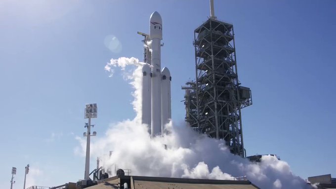
Image copyrightSPACEXImage captionA big exhaust plume rises over the Kennedy launch pad
America's SpaceX company has conducted a key test ahead of the maiden flight of its new rocket - the Falcon Heavy.
In what is known as a static firing, all 27 engines on the launcher's first stage were ignited together to check they are flight-ready.
The procedure, conducted in Florida, lasted only seconds and the rocket was clamped to keep it on the ground.
The Falcon Heavy will be the most powerful launcher in the world when it eventually lifts off.
Depending on the analysis of Wednesday's test, that could occur within the next fortnight.
Company CEO and chief designer, Elon Musk, tweeted: "Falcon Heavy hold-down firing this morning was good. Generated quite a thunderhead of steam. Launching in a week or so."
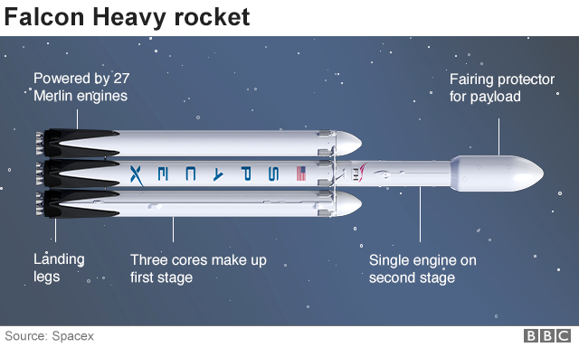
The Falcon Heavy is essentially three of SpaceX's workhorse Falcon 9 vehicles strapped together.
But the triple-booster configuration has demanded a number of specific alterations, including a strengthening of the central core booster.
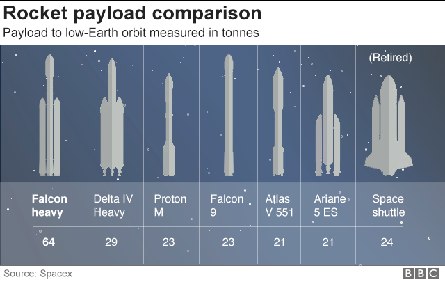
The 27 Merlin engines at the base of the rocket should be capable of generating almost 23,000 kilonewtons of thrust - slightly more than double that of the world's current most powerful rocket, the Delta IV Heavy, which is operated by US competitor United Launch Alliance.
Landing a booster after launch negates some payload performance
The 70m-tall Falcon Heavy is designed to put up to a maximum of 64 tonnes in low-Earth orbit, although in reality it will be rare that the vehicle lofts this much mass.
SpaceX intends to land the rocket's boosters back on Earth after launch - as is the company's usual practice today with the Falcon 9 - and that necessarily negates some performance.
But the new capability would mean the firm in future has no difficult launching the biggest military and commercial telecommunications satellites - and is still able to recover all three first-stage boosters.
The introduction of the rocket should also open up some fascinating possibilities to send much bigger payloads beyond Earth orbit than is currently possible. This could include sending astronaut capsules to the Moon, or bigger robots to Mars.
Because the maiden flight of any rocket carries a higher degree of risk, the Falcon Heavy will not take up a meaningful payload when it finally launches.
Instead, Mr Musk has decided to put his old sportscar on the top of the Falcon Heavy. His idea is to send this red roadster towards the orbit Mars takes around the Sun.
Image copyrightSPACEXImage captionElon Musk's roadster is ready to head in the direction of Mars
Several strange phenomena have led some to believe that the eternal companion of the Earth; the Moon is, in fact, some sort of a huge spaceship. Crazy theory? Well, here’s why.
A curious video taken from a backyard telescope, which showed an alleged UFO fleet over the moon, caused a stir worldwide. This makes us wonder about what could possibly hide in that celestial body. Is it possible that there are civilizations living there if so what is their purpose? and what is its real origin of the moon?
Those who believe in the Alien Moon theory state that the moon had to be created by a highly developed civilization, much more than ours. Under this unusual logic, our artificial satellite would have to be hollow inside so that, within it, the aliens could place fuel for machinery, materials and accessories that would be used to repair working instruments, navigational instruments, observation equipment and all kinds of machinery, but most importantly, it could actually be used as a gigantic underground base or even as a giant spaceship.
If to all of the above we add the fact that there are some astronauts, those who went on NASA’s missions such as the “Apollo”,the now retired astronauts, have publicly said they have had contact with UFO’s and aliens, and that are even extraterrestrial beings living there having that said, for some, this does not sound so crazy after all.
Google Moon Photographs used in the Sea of Muscovy ( were several mysteries have been spotted) come from the Japanese probe Kaguya, also known as SELENE (selenological and Engineering Explorer), which for nearly two years was analyzing various aspects of our satellite, the distribution of elements on its surface, the magnetic and gravitational field, etc. The interest in this particular area is very big, ugolofists claim that this specifica area is very attractive when looking for anomalies thus it is a very interesting part of the moon that holds the answer for several questions that have been postulated throughout the years.
Recently triangular objects have been spotted on the surface of the moon, leading ufologists to speculate about the purpose of the odd objects but sceptics argue that the mysterious objects are actually simple pixels that do not appear in the original image. In addition, they argue that if you look closely you can see a set of other points “scattered” by other areas of the Moon.
The answer to this is that Google stores multiple image frames in various resolutions, using filters that create noise along the boundaries between light and dark regions, creating curios spots that some might interpret as out-of-place-objects. But the pixel theory does not explain geometrical patterns in these objects, if you take in count the pixelation theory, then you would expect the pixels to create random dots not connected, but the objects that have been identified on the moon follow specific geometrical patterns; like triangles and rectangles. Here are some interesting images that can debunk the pixel theory about the lunar bases/objects.
Science might one day provide conclusive evidence of alien beings on the moon, bases, vehicles etc. But the truth is all of us can only wonder and propose theories at this point. Skeptics that debunk the alien moon base theories do not have the slight idea what is going on up there, or why human beings have not traveled to the moon even though it is a point of interest for us not only because of its proximity but also because of the exploitable natural resources present on the moon.
The truth is that the mystery of UFO’s continues, reports of anomalies appear again and again and will probably continue to do so. We can only form our own opinion about these mysterious objects and their origin and purpose.
0
1
2
3
4
5
- Gemiddelde waardering: 0/5 - (0 Stemmen) Categorie:ALIEN LIFE, UFO- CRASHES, ABDUCTIONS, MEN IN BLACK, ed ( FR. , NL; E )
Scientists Explain What Would Happen If The Earth Was Really Flat
Scientists Explain What Would Happen If The Earth Was Really Flat
What Would Happen If The Earth Was Really Flat?
Despite the fact there is ample evidence by which we know our planet is in fact round, there are many people who argue against these facts.
The Flat Earth Society, for example, contends that our planet is, in fact, flat and that the images and videos made available through NASA, ESA, Roscosmos and other space agencies are the results of Computer Generated Images (CGI).
In fact, more than 2,300 years ago, ancient Greek philosophers and Geographers managed to calculate the circumference of our planet and conclude the Earth was round. Eratosthenes of Cyrene, a Greek mathematician, geographer, poet, astronomer, and music theorist, and the chief librarian at the Library of Alexandria calculated the circumference of the Earth.
Eratosthenes was visiting Syene (now Aswan), he observed a phenomenon that caught his attention: at midday, on the summer solstice, no vertical shadows were being cast down. This happened because the Sun was directly overhead.
Upon returning to his city, Alexandria, the mathematician tried to prove if the same thing happened there. He stuck a stick in the ground to see if, at noon, it generated shadows or not.
And of course, there was a shadow, of 7 degrees to be precise. The conclusion that Eratosthenes drew from this phenomenon was the right one: The Earth must be spherical.
Despite the fact there is evidence which proves our planet is round, many people claim it’s not, and that we live on a Flat Earth.
Image Credit: Shutterstock.
That’s great but… what would happen if the Earth was in fact FLAT?
The belief in a flat Earth refuses to disappear from the curious mind of ‘flat-earthers.’
However, and despite the beliefs of the Flat Earth Society, a revealing blog from the Lamont-Doherty Earth Observatory at Columbia University explains what would happen if our planet was flat.
First, a ‘flat Earth’ as the one that the Flat Earth Society defends may not have gravity. It is not clear how gravity would work or be created in such a world, says Lamont Doherty geophysicist James Davis.
This is a huge problem since gravity explains a wide range of terrestrial and cosmic observations.
The same measurable force that causes an apple to fall from a tree also causes the moon to orbit the Earth and all the planets orbit around the sun.
People who believe in a flat Earth assume that gravity acts directly, but there is no evidence to suggest that it works that way.
What we know about gravity indicates that it would pull toward the center of the disk that forms the so-called flat Earth.
That means that it would only pull down at a point in the center of the disk.
As it moved further and further away from the center, gravity would pull more and more horizontally.
This would have some strange impacts, such as sucking up all the water towards the center of the world and causing the trees and plants to grow diagonally, as they develop in the opposite direction to the pull of gravity.
The Sun
Then we have our mighty and beautiful Sun.
In the scientifically supported model of the solar system, the Earth revolves around the sun because the latter is much more massive and has more gravity.
However, the Earth does not move towards to the Sun because it travels in an orbit.
In other words, the sun’s gravity is not acting alone.
The planet is also traveling in a direction perpendicular to the gravitational pull of the star; if it were possible to deactivate that gravity, the Earth would shoot in a straight line and speed out of the solar system.
Gravitation on Flat planet Earth.
Image Credit: Shutterstock
In contrast, the linear pulse and the sun’s gravity combined, result in a circular orbit around the sun.
The Flat Earth theory places our planet at the center of the universe but does not suggest that the Sun orbits the Earth.
On the contrary, the sun rotates on the upper side of the world like a carousel, emitting light and heat downwards like a desk lamp.
Without the linear and perpendicular impulse that helps generate an orbit, it is not clear what force would prevent the Sun and the Moon from hovering above the Earth, says Davis, instead of impacting it.
Satellites: A no go for a Flat Earth
Furthermore, if our planet was, in fact, flat, artificial satellites would probably not be possible.
How would you orbit a plane?
“There is a series of satellite missions that society depends on that simply would not work,” says Davis.
For this reason, he says: “I can not think how GPS would work on a flat Earth.”
If the Sun and Moon simply revolve around one side of a flat Earth, there is likely to be a procession of days and nights.
But it would not explain the seasons, the eclipses and many other phenomena.
A Flat Earth surrounded by a Massive wall made of Ice, according to the Flat Earth Society.
The Sun should also, presumably, be smaller than Earth as to not burn up or crash into our planet or the Moon.
We know that the Sun is more than 100 times the diameter of the Earth.
Deep beneath our planet, the solid core of the Earth generates the magnetic field of the planet.
But on a flat planet, that would have to be replaced by something else.
Maybe a sheet of liquid metal.
That, however, would not rotate in a way that would create a magnetic field.
Without a magnetic field, charged particles from the sun would fry the planet.
This means we would not have an atmosphere, as it occurred on Mars after our neighboring planet lost its magnetic field, causing the air and oceans to escape into space.
Contrary to popular belief, and what is written all over the internet, it is a mistake to think that many societies and educated people believed in the theory of the flat Earth.
“With few extraordinary exceptions, no one educated in the history of Western civilization since the third century of our era believed that the Earth was flat,” noted historian Jeffrey Burton Russell in 1997.
“A round Earth appears at least since the VI century before Christ with Pythagoras, who was followed by Aristotle, Euclid, and Aristarchus, among others, observing that the earth was a sphere,” explained Davis.
Study Finds TRAPPIST-1 Star System Contains Two Potentially Habitable Planets
Study Finds TRAPPIST-1 Star System Contains Two Potentially Habitable Planets
An extraordinary discovery has been made by scientists in the Trappist-1 solar system. Astronomers say that two of the planets orbiting the TRAPPIST-1 star may have ideal conditions for life as we know it to flourish on their surface.
Astronomers have identified that two exoplanets in the TRAPPIST-1 system are more likely to be habitable, according to the eccentricity of their orbits and the consequent tidal heating.
The TRAPPIST-1 system has been of great interest to planetary observers and scientists because it seems to contain seven planets that are approximately the size of Earth.
Amy Barr, a researcher from the Planetary Science Institute, and co-authors Vera Dobos and Laszlo L. Kiss have examined the implications of internal structures and tidal warming on these planets, in a study published in Astronomy & Astrophysics.
The TRAPPIST-1 system.
“Because the TRAPPIST-1 star is very old and dark, the surfaces of the planets have relatively cold temperatures according to planetary standards, ranging from 400 degrees Kelvin, which is colder than Venus, to 167 degrees Kelvin, which is colder than the poles of the Earth,” Barr said in a statement.
“The planets also orbit very close to the star, with orbital periods of a few days, since most of their orbits are eccentric, not entirely circular, these planets could experience tidal heating as well as the moons of Jupiter and Saturn.”
“Assuming that the planets are composed of water ice, rock and iron, we can determine how much of each element could be present, and how thick the different layers could be, because the masses and radii of the planets are not very well restricted, it shows the entire range of possible interior structures and interior compositions,” said Barr.
This graphic compares the distance of planets from the host star in the TRAPPIST-1 system and the solar system.
The team’s results have shown that improved estimates of the masses of each planet can help determine if each of the planets has a significant amount of water.
The planets studied are named by letter, planets b to h, in order of distance from the star.
The analyzes carried out by co-author Vera Dobos show that planets D and E are the most susceptible to being habitable due to their moderate surface temperature, moderate amounts of tidal heating and because their heat fluxes are low enough to avoid entering a state of greenhouse runaway.
A plot of diameter versus the amount of sunlight hitting the planets in the TRAPPIST-1 system, scaled by the size of the Earth and the amount of sunlight hitting the Earth. F. Marchis, H. Marchis
An ocean of global water probably covers the TRAPPIST D.
The team calculated the balance between tidal warming and convective heat transport in the mantles of each planet.
The results show that planets b and c probably have partially melted rock layers.
The document also shows that planet C probably has a solid rock surface, and could have eruptions of silicate magmas on its surface driven by tidal warming, similar to Jupiter’s moon Io.
The figure appears to be wearing shades. Picture: FLYING DISK PRESS
It was a fine October 1957 night in Francavilla on Italy's Adriatic coast - but something extraordinary of the otherworldly kind was about to happen.
At least according to an aerospace expert and sociologist who claims an alien wearing dark shades to cover his eyes when it landed its UFO and let two villagers on board.
Dr Roberto Pinotti, 73, said the human-like beings actually visited often and even posed for pictures. They just wanted to be “friends,” he said.
And in a series of chilling but grainy pictures published in his new book, UFO Contacts In Italy, the author claims to reveal photos of the interior of an alien spacecraft and an extra-terrestrial being.
Picture: A control panel inside the space craft
(FLYING DISK PRESS)
Picture: The alien let two people inside the UFO and even let them take photos, it is claimed
(FLYING DISK PRESS)
The UFO was 24 metres in diameter and the control cabin was 10 meters, claims Dr Pinotti, who is also the founder of Italy’s National UFO Centre.
He said in a statement:
These rare and extraordinary photographs, as well as two photographs of the alleged extraterrestrial pilot… have been published here for the first time.
He added that you can see inside the “cockpit with seating,control panel and other objects.”
Picture: Author Robert Pinotti
(FLYING DISK PRESS)
Speaking to indy100, former director of investigations for the British UFO Association Philip Mantle said that we should keep an open mind but also remain sceptical about UFO claims like this. He said:
It is the easiest thing to do to shout 'fake' or 'hoax' without ever doing any investigation in the first place.
As I have not personally investigated these photos I therefore remain open mind although somewhat sceptical.
I believe the best way to get to the bottom of these photos is to get them into the public domain which is exactly what we have done.
Once you do that then others may come forward with more information that can either support the authenticity of such photos or offer evidence that shows them to be fake.
Mr Mantle added that these photos are very unique as whether fake or real, they show the interior of a UFO. There are many photos that claim to show extraterrestrial spacecraft but not many from the inside.
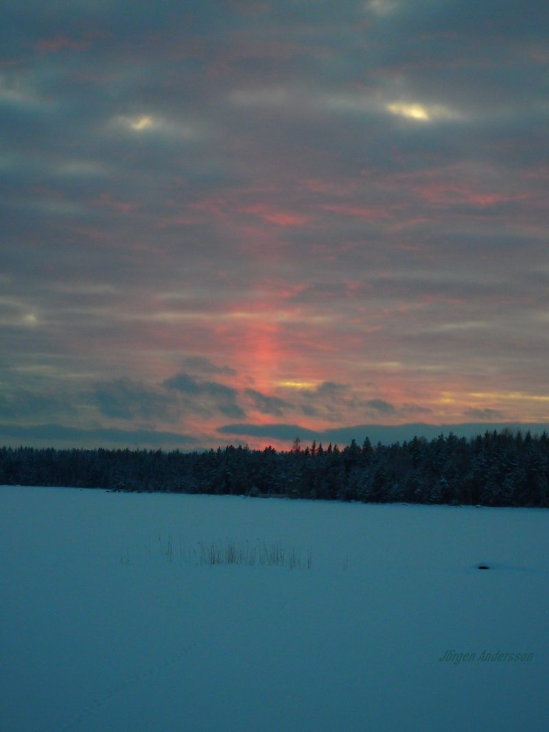
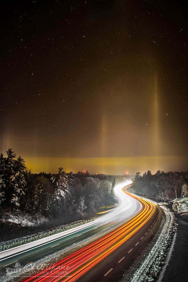
Sun pillars, or light pillars, are shafts of light extending from the sun or other bright light source. They’re caused by ice crystals drifting in Earth’s air.
Canada geese look like ghosts as they fly though a sun pillar – January 28, 2017 – in Quakertown, Pennsylvania.
EarthSky Facebook friends occasionally post beautiful photos of sun pillars, or light pillars. For example, there was a beautiful one seen from the U.S. West Coast on March 20, 2016 … a beautiful prelude to the first full night of spring. Sun pillars are vertical shafts of light that extend upward (or downward) from a bright light source, such as the sun or other bright light low on the horizon. They can be five to 10 degrees tall and sometimes even higher. They might lengthen or brighten as you gaze at them.
They’re beautiful and wondrous. They’re also the source of some UFO reports!
Joe C. Tabb and Dawn Tabb caught this amazing sun pillar at sunset on May 10, 2016. A storm had recently passed.
The U.S. West Coast got an amazing sun pillar on the first evening of spring, 2016. Photo by Lyle Evans in Highland, California.
Another shot of the beautiful sun pillar seen on March 20, 2016, from the U.S. West Coast. This one is from Chris Levitan Photography. Thanks, Chris!
Sun pillars or light pillars are formed by reflection from hexagonal plate-like ice crystals in Earth’s air. These crystals drift through the atmosphere with a horizontal orientation, gently rocking from side to side as they fall. Diagram via University of Illinois.
Sun pillars or light pillars form when sunlight (or another bright light source) reflects off the surfaces of millions of falling ice crystals associated with thin, high-level clouds, for example, cirrostratus clouds. The ice crystals have roughly horizontal faces. They are falling through Earth’s atmosphere, rocking slightly from side to side.
When is the best time to see a sun pillar or light pillar?
µYou’ll most often see sun pillars when the sun is low in the western sky before sunset, or low in the east just after the breaking of dawn. You might even see a sun pillar when the sun is below the horizon. Light pillars can be seen at any time of night.
View larger. | Wesley Liikane in Severn Bridge, Ontario captured these light pillars on December 23, 2013. See more photos by Wesley at Cowboy with a Camera on Facebook.
They’re called sun pillars when the sun helps make them. But this the moon or even streetlights can create this light phenomenon, too, in which case the name light pillar is more appropriate.
These pillars of light often prompt people to report sightings of UFOs. They can sometimes look strange! There are said to be a lot of UFO reports caused by light pillars over Niagara Falls, where the mist from the rush of descending water interacts with the city’s many upward facing spotlights. Light pillars do appear frequently over Niagara Falls, especially during the winter.
As always, the great website Atmospheric Optics is a wonderful place to go and learn more about sun pillars.
Photo credit: EarthSky Facebook friend Kim Smith, taken February 2013. She says “My first ever sun pillar! We don’t often see them here in Walker Creek, Arkansas. I am glad I was out to photograph the sunset today when this occurred.” Thanks Kim!
Bottom line: Sun pillars, or light pillars, are vertical shafts of light that can sometimes be seen extending upwards or downwards from the sun or other bright light source. They’re caused by light reflection from hexagonal ice crystals drifting in Earth’s atmosphere.
DOUBLE TROUBLE Cloned macaque sisters Zhong Zhong and Hua Hua, the first primates successfully cloned via somatic cell nuclear transfer, are just 8 and 7 weeks old, respectively.
QIANG SUN, MU-MING POO/CHINESE ACADEMY OF SCIENCES
Meet Zhong Zhong and Hua Hua, the first primates cloned by reprogramming adult cells.
Two decades after Dolly the Sheep was successfully cloned(SN: 3/1/97, p. 132), Chinese researchers have used the same technique — somatic cell nuclear transfer — to clone two healthy baby macaque monkeys. The results, reported January 24 in Cell, could lead to more efficient cloning and a better way to study genetic diseases in primates.
“This could be it — the next step in cloning,” says Jose Cibelli, a geneticist at Michigan State University in East Lansing not involved with the study.
Over 20 species of mammals have been cloned via somatic cell nuclear transfer — including cats, dogs, rats and even a camel (SN: 3/23/02, p. 189). This cloning technology has improved since Dolly’s birth in 1996. Back then, she was the only sheep born from 277 attempts. By 2014, the cloning technique had an 80 percent success rate in pigs. Despite these gradual advances (SN: 3/8/14, p. 7), cloning of nonhuman primates has long eluded researchers.
A rhesus monkey “clone” was created through embryo splitting, a technique that divides a single embryo into genetically identical embryos, in 1999. But this type of cloning has little in common with somatic cell nuclear transfer.
In somatic cell nuclear transfer, a nucleus from a mature body cell is transplanted into an egg cell without a nucleus. The egg cell must then reprogram the nucleus’s DNA, basically stripping the body cell of its identity and returning it to an embryonic state. With no set identity, it can become any kind of cell in the body.
TWICE THE FUN Zhong Zhong and Hua Hua, the first primates successfully cloned via somatic cell nuclear transfer, are healthy, playful and, so far, completely normal for baby macaques. The sisters will spend the next few months in an incubator together.
Previous failures in reprogramming primate cells probably happened because the egg ran into roadblocks — portions of the body cell’s DNA known as reprogramming-resistant regions, say study coauthor Mu-ming Poo, director of the Institute of Neuroscience at the Chinese Academy of Sciences in Shanghai, and his colleagues. In these regions, DNA is so tightly wrapped around proteins called histones that the egg can’t reprogram those bits. So the researchers added two molecules aimed at loosening the DNA’s packaging.
The team tried this method with two types of body cells: ovarian cells from an adult and connective tissue cells from a fetus. Although 22 out of 42 monkeys became pregnant with embryos cloned from ovarian cells, only two babies were born and neither survived long past birth. Efforts with embryos made with the fetal cells resulted in six pregnancies among 21 surrogate monkey moms and two healthy babies.
“After 20 years of trying from the most talented groups, and nothing working, finally this works,” Cibelli says. “This research is going to help cloning of all species.”
Cloned primates could help researchers better understand diseases in humans. Macaques are close genetic relatives to humans, making the monkeys better analogs than other lab animals. And clones make it easier to weed out the complications of different genetics when studying diseases or testing drugs.
The sisters are just a few weeks old, but they hold a lifetime of promise for researchers. Poo says the scientists will watch for any abnormalities as Zhong Zhong and Hua Hua grow and play.
“The monkeys are in good health and very active,” he says. “There are no signs they are unhealthy.”
Beste bezoeker, Heb je zelf al ooit een vreemde waarneming gedaan, laat dit dan even weten via email aan Frederick Delaere opwww.ufomeldpunt.be. Deze onderzoekers behandelen jouw melding in volledige anonimiteit en met alle respect voor jouw privacy. Ze zijn kritisch, objectief maar open minded aangelegd en zullen jou steeds een verklaring geven voor jouw waarneming! DUS AARZEL NIET, ALS JE EEN ANTWOORD OP JOUW VRAGEN WENST, CONTACTEER FREDERICK. BIJ VOORBAAT DANK...
Druk op onderstaande knop om je bestand , jouw artikel naar mij te verzenden. INDIEN HET DE MOEITE WAARD IS, PLAATS IK HET OP DE BLOG ONDER DIVERSEN MET JOUW NAAM...
Druk op onderstaande knop om een berichtje achter te laten in mijn gastenboek
Alvast bedankt voor al jouw bezoekjes en jouw reacties. Nog een prettige dag verder!!!
Over mijzelf
Ik ben Pieter, en gebruik soms ook wel de schuilnaam Peter2011.
Ik ben een man en woon in Linter (België) en mijn beroep is Ik ben op rust..
Ik ben geboren op 18/10/1950 en ben nu dus 75 jaar jong.
Mijn hobby's zijn: Ufologie en andere esoterische onderwerpen.
Op deze blog vind je onder artikels, werk van mezelf. Mijn dank gaat ook naar André, Ingrid, Oliver, Paul, Vincent, Georges Filer en MUFON voor de bijdragen voor de verschillende categorieën...
Veel leesplezier en geef je mening over deze blog.